Unmanned landing sites from LRO, Surveyors, Lunas, Lunakhods and impact craters from hardware impacts |

Unmanned landing sites from LRO, Surveyors, Lunas, Lunakhods and impact craters from hardware impacts |
 Sep 7 2009, 07:51 PM Sep 7 2009, 07:51 PM
Post
#201
|
|
 Senior Member  Group: Members Posts: 3419 Joined: 9-February 04 From: Minneapolis, MN, USA Member No.: 15 |
I figured it was time to begin a thread like this, especially since some of us may still be looking for the Surveyor III retro motor casing (assuming the bright dot to the north of the landing site isn't it).
We ought to be seeing some of the other Surveyors fairly soon, I would think. We know most of their locations pretty accurately. Again, I think there is a lot to be gained, both from scientific and engineering standpoints, from detailed imaging of the Surveyor VII landing site, just to mention one. And I really want to see how visible the Lunakhod tracks are as opposed to the MET and LRV tracks. So... until we begin to see images of other unmanned hardware (or the craters caused by same), we could always discuss comparisons of Surveyor III surface imagery to the new LROC images of its landing site here. I'm especially taken by how you can resolve many of the blocks in Block Crater in the LROC image, which gives you a good feel for the explosive nature of the ejecta and roughly where in the ejecta plume a given block might have come from. Might be interesting/useful to apply this information to the samples taken at that location.  -the other Doug -------------------- The trouble ain't that there is too many fools, but that the lightning ain't distributed right. -Mark Twain
|
 |
 
|
 |
|
Sep 12 2022, 11:53 PM
Post
#202
|
||
|
Solar System Cartographer Group: Members Posts: 10162 Joined: 5-April 05 From: Canada Member No.: 227 |
OK, I have been pondering this. Ponder, ponder - there, I just did it again.
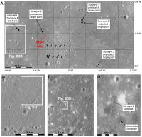
Here is my guess for Surveyor 4:
This shows the Surveyor 4 target as it evolved from before launch to after launch (when they had a better idea of the trajectory and could shrink the landing ellipse) and where tracking suggested it actually went. The failure came at or just before the end of the retro burn, which did most of the job of bringing it to the surface, so it should be fairly close to the tracking location. The site I zero in on shows two little dark spots. When you start looking at the high sun LROC NAC images there are a surprising number of little dark spots and it is not at all easy to decide which to pick. My rationale is that the retro burn was probably completed and the failure occurred when the small vernier thrusters took over from the retro system. Therefore I assume the retro engine fell to the ground as expected rather than exploding into fragments. So I was looking for a place where there were two dark spots, one for the lander and one for the retro rocket system. The one I found has two spots about 200 m apart, which is roughly what we see for the two where we know we have it right from before/after images (Surveyor 3, Surveyor 6). But other searches might find different candidates. Shan's point is close to the target but quite a long way from the tracking location. So I still prefer mine for the time being. But I will change my mind if someone finds a better candidate. Phil -------------------- ... because the Solar System ain't gonna map itself.
Also to be found posting similar content on https://mastodon.social/@PhilStooke Maps for download (free PD: https://upload.wikimedia.org/wikipedia/comm...Cartography.pdf NOTE: everything created by me which I post on UMSF is considered to be in the public domain (NOT CC, public domain) |
|
|
|
|
|
 dvandorn Unmanned landing sites from LRO Sep 7 2009, 07:51 PM
 Shan Phil,
Whether this could be Surveyor4's retro... Aug 20 2022, 09:10 AM Phil Stooke Hi Shan. Give me a few days to consider this. It... Aug 21 2022, 07:13 AM
Shan Phil,
Whether this could be Surveyor4's retro... Aug 20 2022, 09:10 AM Phil Stooke Hi Shan. Give me a few days to consider this. It... Aug 21 2022, 07:13 AM |

|
Lo-Fi Version | Time is now: 16th May 2024 - 04:15 PM |
|
RULES AND GUIDELINES Please read the Forum Rules and Guidelines before posting. IMAGE COPYRIGHT |
OPINIONS AND MODERATION Opinions expressed on UnmannedSpaceflight.com are those of the individual posters and do not necessarily reflect the opinions of UnmannedSpaceflight.com or The Planetary Society. The all-volunteer UnmannedSpaceflight.com moderation team is wholly independent of The Planetary Society. The Planetary Society has no influence over decisions made by the UnmannedSpaceflight.com moderators. |
SUPPORT THE FORUM Unmannedspaceflight.com is funded by the Planetary Society. Please consider supporting our work and many other projects by donating to the Society or becoming a member. |
|