Printable Version of Topic
Click here to view this topic in its original format
Unmanned Spaceflight.com _ Spirit _ Home, Sweet Home
Posted by: Shaka Feb 5 2006, 06:46 PM
Hope no one minds, but I felt we have to have a new topic, right from the start, as a compendium of all the Factual Observations on this incredible structure...this Mother Ship from another world...this...(who said Burgess Shale? I laughed at that at the time.  ) Who will start us off with a detailed description of what we see before us TODAY February 5, 2006 - Super Sunday.
(I'll be running from game to Exploratorium all afternoon! 
Posted by: Shaka Feb 5 2006, 09:44 PM
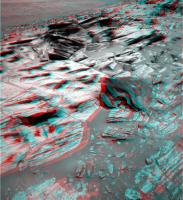
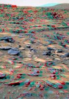
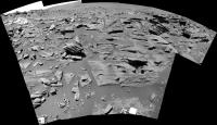
O.K. We're there, and we might as well start at the bottom and work up.
I've cropped an area of slabs at the base of the section and assigned working names so we can easily refer to them. So,
can some of the field geologists give the non-geos among us a description of the types they see and list things they could be?

|
For example, to my untutored eye, the rocks El over to Ward represent a group of similar layers. Are they different in some significant way from the slabs Darby and Bernard just above? Is the upper layer likely to be of different origin or makeup? Obviously we don't have spectrometry now, so this is a visual-only exercise. Have we seen anything even remotely related to HP in Gusev so far?
C'mon, rockhounds! We're all ears!

P.S. Steelers by 3
Posted by: Burmese Feb 6 2006, 07:02 PM
Ok, the 'Going to Home Plate' thread is getting a bit long for me, so I thought I start a new topic now that we are 'there'.
I'm thinking that the MER team may already be contemplating ways to either ride out winter at HP/PM or how to at least extend their stay further into winter (perhaps 'Island hopping' thru north-facing slopes between HP and McCool Hill when they do leave). If they decide to stay, they might do the top of HP early on, then more of the north-facing perimeter deeper in the winter, then hop around to the north side of PM?
Posted by: Mongo Feb 6 2006, 07:12 PM
We already have a new thread about the arrival at Home Plate:
http://www.unmannedspaceflight.com/index.php?showtopic=2189
Bill
Posted by: Burmese Feb 6 2006, 07:14 PM
Oops, sorry, didn't spot that one!
Posted by: mhoward Feb 6 2006, 07:15 PM
Check out the http://flickr.com/photo_zoom.gne?id=96390608&size=o, as it were, from our position next to Home Plate. Yes, I know, I shouldn't say "out to sea" because the Martian Tricorder crowd will take me seriously, but I just can't help myself, the view is so evocative of a bay or something  The view is due West by the way, 90 degrees wide.
Edit: Oops, I guess we should go with the other thread, although I like the title of this one better.
Posted by: Burmese Feb 6 2006, 07:25 PM
And the atmosphere is clearing a bit, I think!
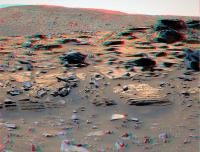
Posted by: gpurcell Feb 6 2006, 07:44 PM
The granular lower level intrigues me. Could be an ashfall layer, or we could be seeing grain size differences based on water velocity.
To go way, way out on a limb, there seems to be some periodicity within the coarse layer. Perhaps a series of flooding events? Above it is the finer-grained material...perhaps lacrustine sediments overlaying the initial coarse material following the water filling the basin?
Posted by: Shaka Feb 6 2006, 08:34 PM
To go way, way out on a limb, there seems to be some periodicity within the coarse layer. Perhaps a series of flooding events? Above it is the finer-grained material...perhaps lacrustine sediments overlaying the initial coarse material following the water filling the basin?

Thanx. I assume the entire Steelers backfield (sorry about the mixing of sports - Is this, by the way, the outcrop dubbed Gibson ?), is float that has fallen from above, so the El - Ward line is the base of this section. From this distance (When is Explo./JPL going to release today's photos??) the granular layer seems to have shadowed interstices (sorry I don't speak good Geo ). Would that favor a 'scoriaceous' kind of ashfall over a lacustrine gravel bed?
Can we put any time constraints on this section? Is it less than a million years of accumulation, or given the nature of Mars could it be almost any duration?
(Insert emoticon for sitting-at-your-feet-with-rapt-attention)
Posted by: Bill Harris Feb 6 2006, 09:15 PM
Just off the top of my head: the reason Spirit needs to be on a north-facing slope in Winter is that the Sun moves into the northern sky and the solar panels need to be tilted northward to keep them aligned with the Sun. FWIW, at 14 degrees south latitude the Sun will be no higher than 53* above the northern horizon.
But since the Sun moves NorthEast to due North to NorthWest, it the panels need to be oriented NE in the morning, N at noon and NW in the afternoon, so it seems that it could add a northwest-biased tilt in the afternoon for optimum solar output. That NW slope would be easily obtainable on the NW slope of McCool Hill, which could expand the envelope of possible paths.
It will be interesting to see how the mission planners do this Winter.
--Bill
Posted by: vikingmars Feb 6 2006, 09:21 PM
I hope we will have some time also to climb on top of Home Plate.
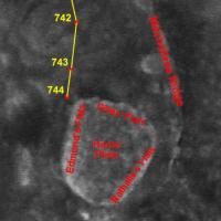
Here are the names I gave to its 3 major albedo structures seen from orbit : a tribute much deserved to the 3 Home Plate discoverers : Dr. Nathalie Cabrol and Dr. Edmond Grin, not forgetting Gilles Dawidowicz, their intern student, who pintpointed Home Plate's interest from the very beginning ! Links :
http://www.unmannedspaceflight.com/index.php?showtopic=2116&view=findpost&p=38492
http://www.unmannedspaceflight.com/index.php?showtopic=2116&view=findpost&p=38541
|
Posted by: Nirgal Feb 6 2006, 10:46 PM
hand-colorized Sol 744 "Home Plate" panorama and Sol 743 navcam "El-Dorado Looking Back" Navcam-Panorama:
http://mitglied.lycos.de/user73289/misc/spirit_p744_col_d.jpg
http://mitglied.lycos.de/user73289/misc/spirit_n743_col_b.jpg
(as always, those colors only reflect my subjective vision of the otherwise b/w landscape and may be way off the "true" spectrum ... 
Posted by: mars loon Feb 6 2006, 11:04 PM
Bernhard,
these are fantastic and puts it all in perspective that HP has suffered an extremely violent event(s). And the layering on the right will I hope be an early target before climbing up as well as the richly layered areas and tire like tracks towards the left.
this is a dream come true for all. Not surprisingly, SS sure was fast this time with an update
ken
Posted by: mars loon Feb 6 2006, 11:16 PM
I hope we will have some time also to climb on top of Home Plate.Here are the names I gave to its 3 major albedo structures seen from orbit : a tribute much deserved to the 3 Home Plate discoverers : Dr. Nathalie Cabrol and Dr. Edmond Grin, not forgetting Gilles Dawidowicz, their intern student, who pintpointed Home Plate's interest from the very beginning ! Links :
Olivier
yeah I cant imagine the MER team not climbing on top unless there is no safe path
and thanks for the backgroud on HP discoverers. I had missed that earlier and just checked out those illuminating presentations
ken
Posted by: Steve Feb 6 2006, 11:17 PM
these are fantastic and puts it all in perspective that HP has suffered an extremely violent event(s)....
ken
Ken,
The shards of shattered rock need not indicate extremely violent event(s). They look just like the kind of fragments one finds at the foot of mesas in Northern Arizona. The (admittedly uniformitarian) consensus is that those are the result of slow processes in which pieces of rock broke off, fell, shattered, and tumbled down the slope.
I suspect similar processes took place at Home Plate.
Steve
Posted by: RNeuhaus Feb 7 2006, 01:40 AM
I look forward in hearing from JPL's activity plan around HP. Will Spirit circle around it before climbing into HP. I think that the most important step at HP is to circle around it due two strong reasons:
1) A scientific method that starts from outside into inside. This method help to understand better the nature of HP first by visting the outside that might influence it.
2) Now it is spring, there is more light now than tomorrow, so Spirit must take the advantage of it in the early to spend more solar energy to circle around HP before climbing into HP.
3) You name it if you have a good guess about the next Spirit move !!!
Rodolfo
Posted by: Sunspot Feb 7 2006, 01:52 AM
They need to put the MI on the rock in the top left of this image
http://marsrovers.jpl.nasa.gov/gallery/all/2/p/744/2P192419384EFFAO00P2363R1M1.HTML
Posted by: Bill Harris Feb 7 2006, 01:55 AM
The fragments look like the rock was formed by cyclic deposition events, and have a shattered appearance because of extreme diurnal thermal cycling. I'm interested in seeing the "basement' unit below this layered unit. I imagine that an impact ought to show shattercones (or other signs).
This looks like a weathered outcrop.
--Bill
Posted by: RNeuhaus Feb 7 2006, 01:58 AM
http://marsrovers.jpl.nasa.gov/gallery/all/2/p/744/2P192419384EFFAO00P2363R1M1.HTML
Do MI on the laminated fallen rock? It looks it was detached from the rim of HP and later it was eroded by the aeolian process, does it not?
Rodolfo
Posted by: Sunspot Feb 7 2006, 02:05 AM
Yep...thats the one. Also Spirit would be in a great spot for some closeup pancams of the rest of the layered outcrop.
Posted by: Shaka Feb 7 2006, 02:56 AM
Abso-freakin'-lutely! So where are today's photos at Exploratorium? Don't they know we're dyin' out here waiting for some close-ups? I've been at this keyboard so long I see 164 keys! What's going on? We're hooked now; they can't cut us off cold turkey!
 (I don't know what this emoticon means, but it's indicative of my mental state.)
Posted by: ddeerrff Feb 7 2006, 02:59 AM
http://marsrovers.jpl.nasa.gov/gallery/all/2/p/744/2P192419384EFFAO00P2363R1M1.HTML
You mean the piece of broken pottery?
Posted by: ilbasso Feb 7 2006, 03:00 AM
That "laminated fallen rock" almost looks like a shard of pottery in an archaeological dig.
Posted by: Shaka Feb 7 2006, 03:22 AM
This looks like a weathered outcrop.
--Bill
Yes, definitely. I don't see it on this side. I think we must get a look at the west side.
Posted by: Shaka Feb 7 2006, 03:25 AM
No, he means the old porcelein commode.
...gasp....getting delirious...must rest soon...rest...yeeeesss
Posted by: Richard Trigaux Feb 7 2006, 08:29 AM
Hi all,
there was recently another thread http://www.unmannedspaceflight.com/index.php?showtopic=2116&st=105&p=40489& with a friendly competition about trying to understand Homeplate before we actually see and analyse it.
It seems that I was a bit close to what we see: (predicting a three-layered system)
Sometimes between the formation of Gussev and the final filling by mudflow, there was a lake (temporary, or permanent). The surface of this lake was about the level of Homeplate, or a little above, so that Husband hills were not covered. Its open surface lasted only some days, and after the surface frozen, and eventually all the water froze to the core in some months or years.
This water was charged with a variety of salts, and these salts were deposited, but very unevenly, from the presence of ice, after one or several of the following processes:
-waves projected water on mounds, where it evaporated very quickly, lefting the salts on priviledged patches. (This is sometimes visible on earth)
-there were faults in the ice cover, allowing strong evaporation of water in some very restricted places.
-There was a continuous ice cover, see the lake froze into its whole depth. But salts were contentred in tiny patches of very salty brines, which can exist at very low temperatures (-50°C for calcium chloride). When ice sublimated, it left the solid salt patches to end drying. Homeplate could be one of these patches. Other were observed all around.
So if this model is true, it predicts that Homeplate and similar smaller patches are just salts. Eventually we may find, from top to bottom:
-basaltic blocks and sands, projected here by more recent impacts
-most soluble salts, such as sodium and calcium chlorides
-less soluble salts, such as jarosite and sulphates
-eventually an iron oxyd layer somewhere in between
-at bottom a sandstone of basaltic sand cemented with sulphates or carbonates (eventually limestone). This layer would be the dark rocky outcrop which seems to encircle Homeplate.
-a "discordance" and under ordinary soil (same as elsewhere around).
...
and that Homeplate would be the same thing than a much larger similar structure, that of http://www.unmannedspaceflight.com/index.php?showtopic=1698
Posted by: Bill Harris Feb 7 2006, 10:12 AM
Richard--
I'm witholding judgement until we know more about the lithologies...
--Bill
Posted by: Burmese Feb 7 2006, 03:43 PM
Does this image show Bonneville in the upper left?
http://qt.exploratorium.edu/mars/spirit/navcam/2006-02-06/2N192497495EFFAO00P1785L0M1.JPG
If so, it is a very nice view of the route between Bonneville and West Spur.
Posted by: SigurRosFan Feb 7 2006, 04:05 PM
I mean no, Bonneville is rather behind the rocky hill in the upper right. The crater (upper left) is exactly to the west.
Posted by: ElkGroveDan Feb 7 2006, 04:08 PM
Posted by: Burmese Feb 7 2006, 08:00 PM
A run, a short followup bump, set the wheels, and they are clearly in position to do IDD work (assuming the wheels are stable now). Talk about precision driving!
http://qt.exploratorium.edu/mars/spirit/forward_hazcam/2006-02-07/2F192595616EFFAO38P1201L0M1.JPG
http://qt.exploratorium.edu/mars/spirit/forward_hazcam/2006-02-07/2F192597691EFFAO55P1214L0M1.JPG
Do you want your laminations thick or thin?
http://qt.exploratorium.edu/mars/spirit/navcam/2006-02-07/2N192597856EFFAO55P0685L0M1.JPG
Posted by: Bill Harris Feb 7 2006, 08:03 PM
I just regained my power of speech and I'm again speechless. The view is great, and that was some fancy driving.
I'll take my laminations any way I can get them...
--Bill
Posted by: jabe Feb 7 2006, 08:05 PM
Is it me or does it look nice and smooth up top? thought it would be "bumpier"..easy riding when they get up top to scoot around to other outcrops on HP once they leave the "wall"..which probably won't be for a while..
Posted by: mhoward Feb 7 2006, 08:07 PM
This is the view looking 45 degrees down directly in front of Spirit:
http://flickr.com/photo_zoom.gne?id=96858796&size=l
So as near as I can tell, we must be parked at about a 45 degree angle. Really amazing driving. Edit: Okay, maybe more like 30 or 35.
Unbelievable.
Edit: Also near as I can tell, we are facing approximately southeast So the solar panels are pointed roughly northwest.
Posted by: odave Feb 7 2006, 08:11 PM
...best parking job I've seen since Elwood swung the Bluesmobile into that spot outside of Chez Paul.
Posted by: Tman Feb 7 2006, 08:13 PM
The last pictures show so many layers in the Plate - that wasn't an impact event, was it.
If it was not a single event that caused the layers then I would think Home Plate is the rest of a filled crater as "the other" Doug has mentioned earlier - or maybe a filled little extinct volcano. That scenario would open a very big book of ancient time - like a tree trunk.
Posted by: dilo Feb 7 2006, 08:20 PM
Really sweet!
It seems drivers are very, very aggressive: almost 30deg inclination from sideview!
They are climbing to the top, apparently (you can see the plateau now)...
|
Posted by: mhoward Feb 7 2006, 08:25 PM
Here's a http://www.flickr.com/photo_zoom.gne?id=96867808&size=l and a http://www.flickr.com/photo_zoom.gne?id=96867814&context=photostream&size=l.
Posted by: Shaka Feb 7 2006, 08:35 PM
It seems drivers are very, very aggressive: almost 30deg inclination from sideview!
They are climbing to the top, apparently (you can see the plateau now)...
 Is that possible here, Dilo? What angle of slope is this face?
Posted by: jvandriel Feb 7 2006, 08:39 PM
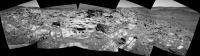
Here is the view of Homeplate on Sol 744.
Taken with the R0 navcam.
jvandriel
|
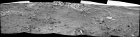
Posted by: jvandriel Feb 7 2006, 08:40 PM
and here Spirit looking back on Sol 745.
Taken with the L0 navcam.
jvandriel
|
|
Posted by: mhoward Feb 7 2006, 08:41 PM
Good grief - imagine what the Pancams will look like.
Posted by: Nirgal Feb 7 2006, 08:46 PM
latest L7-pancam (synthetic colors)
http://mitglied.lycos.de/user73289/misc/spirit_n745_col_b.jpg
Posted by: dilo Feb 7 2006, 08:54 PM
Is that possible here, Dilo? What angle of slope is this face?Look at http://qt.exploratorium.edu/mars/spirit/navcam/2006-02-07/2N192598689EFFAO55P1926L0M1.JPG if you don't believe me!
And this is the straightened side view:

|
Posted by: mhoward Feb 7 2006, 08:54 PM
Nice, Nirgal! Fast work, too; I'm pretty sure those frame just came down within the last couple hours.
Boy, AutoStitch gets the jaggies with those heavily tilted frames as bad as MMB does. Funny.
Posted by: djellison Feb 7 2006, 08:55 PM
They wont climb to the top here ( infact, they'd have no chance ) - but they're in a 'Hillary' type position- parked up a bit of a slope probably as far as the rover will go - wheel wiggle to settle it - and IDD away
Doug
Posted by: Richard Trigaux Feb 7 2006, 08:56 PM
I'm witholding judgement until we know more about the lithologies...
--Bill
You are right
Posted by: Ames Feb 7 2006, 09:01 PM
Looks like a good angle to catch some rays and recharge! - Ahhhhh!
A little reminiscent of burns cliff.
Nice work!
Nick
Posted by: jvandriel Feb 7 2006, 09:04 PM
Here is the view from Sol 744 into the drive direction.
Taken with the L7 pancam.
jvandriel
|
|
Posted by: Richard Trigaux Feb 7 2006, 09:09 PM
And http://www.unmannedspaceflight.com/index.php?act=Attach&type=post&id=3956:
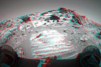
If you notice a strange thing, which is visible on le big dark loose rock on the left, and also on other places more to the left: it is as if spherical volumes of strata were missing. Even if you look well at the left, a spherical volume is missing, and the strata are folded, as if they had formed around a spherical object. I am not sure, but it looks that these layers contained something like giant blueberries, but which are no more in place today, because they were eliminated by erosion or something else.
Posted by: SigurRosFan Feb 7 2006, 09:14 PM
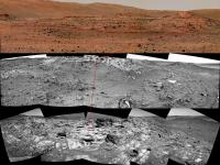
Here's a new rover view ...
Today's (Sol 746) Spirit (506 KB):
http://xs67.xs.to/pics/06062/Sol_746_Spirit_Homeplate.jpg
Posted by: Burmese Feb 7 2006, 09:19 PM
http://qt.exploratorium.edu/mars/spirit/navcam/2006-02-07/2N192598580EFFAO55P1926L0M1.JPG
Are we looking at the bottom of this layered caprock, or is it simply diving down below the surface?
Posted by: Richard Trigaux Feb 7 2006, 09:23 PM
I must say that there is a tremendous work made to present readable images from raw data!!! Hi all!!
Posted by: djellison Feb 7 2006, 09:24 PM
two threads merged
Posted by: dilo Feb 7 2006, 09:39 PM
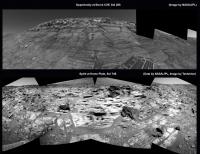
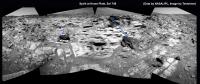
Today's (Sol 746) Spirit (506 KB):
Wow Doug! I was preparing this sequence in order to identify HP features, but you did better!
|
(Sol 743-744-746 from top to bottom)
Posted by: mars loon Feb 7 2006, 11:12 PM
Are there estimates on how high is HP above the surrounding terrain? 15 - 20 ft , 5-7 m?
and info on when they may plan a drive around to check for a safe path to climb up?
Posted by: Bill Harris Feb 7 2006, 11:18 PM
I don't know what the structure is here. From the image that Burmese pointed at, it does look that the layers are dipping towards the interior of Homeplate. It looks that the caprock at Pitchers Mound is dipping towards HP. Dipping at 20 or so degrees. I'd expect essentially flat-lying or gently dipping.
We need to get to the other side of HP and look, and look at PM.
--Bill
http://qt.exploratorium.edu/mars/spirit/navcam/2006-02-07/2N192598580EFFAO55P1926L0M1.JPG
Posted by: Shaka Feb 7 2006, 11:29 PM
Ah, the Operating Theater ! Very fine, Dr. Nirgal!
Now, Doctors, where shall we make the First Incision ?
How about:

|
Rats, no Rat! Where shall we make the First Abrasion ?
Other suggestions?
Posted by: dilo Feb 7 2006, 11:30 PM
Much less than this, Ken. If you consider that Spirit NavCam is able to see the plateau surface while standing at only 1/3 of the total wall height, elevation should be slightly above 2 meters in the rightmost (North-West) side and, perhaps, less than 1m in the East side... look also to the simulated Doug's view, few posts above...
Posted by: Zeke4ther Feb 8 2006, 04:45 AM
Could these voids not be cause by aeolian errosion sandblasting out a void? I've seen something similiar in the rocks around Colorado Springs.
Posted by: abalone Feb 8 2006, 07:58 AM
Wow!!
|
Posted by: djellison Feb 8 2006, 08:17 AM
Other suggestions?
The Rat's ability to grind has been lost for months - it's worn out. They can brush, but not grind.
Doug
Posted by: Tesheiner Feb 8 2006, 09:22 AM
A combination of two panoramas.
Oppy at Home Plate on top, and Spirit at Burns Cliff at ... no, wait a minute! Oppy at Burns Cliff at the bottom and Spirit at... wrong again! Man, they are so similar.
Well, judge by yourself.
|
Posted by: Bob Shaw Feb 8 2006, 09:32 AM
Indeedy!
Firstly, look beyond the immediate eye-candy - HP *is* a bowl, we're looking across the top surface in the background and it clearly has a 'crater' shape (as in bowl, no more).
Secondly, I agree that the form of the exposed surfaces is, as previously said, all about the tricks of aeolian erosion - you get some very strange shapes, and they don't need to mean much except the way the winds blow.
Thirdly, the fine stratification has to mean persistent episodes of "something". Dykes don't do that, ashfall seems less likely to me now, water more so, but...
...mud pseudo-vulcanism?
And finally: I know it can't be, but... ...lithographic slate? Anybody seen any Archeopteryx? Answers, on a postcard please, to Mr R Hoaxland...
Bob Shaw
Posted by: abalone Feb 8 2006, 10:28 AM
Hazcam view
|
Posted by: Bill Harris Feb 8 2006, 11:25 AM
I dunno where we are! However, it does suggest the effects of similar aeolian erosion on rocks of similar mechanical properties.
Google "loess". There is a wealth of information on it and it may apply here *only in the context of a windblown deposit*.
--Bill
Posted by: djellison Feb 8 2006, 11:30 AM
It does strongly remind me of Burns Cliff - the middle parts that are suggested as being depositied by wind, and then being altered by water. Who knows. Why is it here? What IS Home Plate, what's that stuff made of, ahhhhh---it's all too much
Big MI sequence tosol it seems, Spirits IDD will get a work out today.
--- -------- --- --- --- --- --- ---- -----------
747 p1110.03 2 0 0 2 0 4 front_haz_idd_mi_doc_1024x1024x1bpp_pri_56
747 p1131.05 2 0 2 0 0 4 front_haz_idd_mb_doc_512x512x1_bpp_high
747 p1206.05 2 0 0 2 0 4 front_hazcam_half_bpp_pri_20
747 p1214.05 2 0 0 2 0 4 front_hazcam_ultimate_4_bpp
747 p1244.00 2 2 0 0 0 4 front_hazcam_wheel_sub_256x256_4_bpp_pri_16
747 p1344.00 3 3 0 0 0 6 rear_hazcam_sub_LRREYES_256x256_4bpp_pri23
747 p2102.13 3 0 3 0 1 7 pancam_isc_voc_cal_L267
747 p2104.10 3 0 3 0 1 7 pancam_mtes_cal_target_L267
747 p2578.15 6 0 0 6 2 14 pancam_mackey_L257R247
747 p2600.07 2 2 0 0 2 6 pancam_tau
747 p2600.07 2 2 0 0 2 6 pancam_tau
747 p2631.01 11 0 0 0 2 13 pancam_sky_spot_L234567R34567
747 p2818.07 6 6 0 0 2 14 pancam_cal_target_L257R247
9x
747 p2936.02 1 0 0 1 0 2 mi_cover_open_minloss2_LUT3_pri44
20x
747 p2956.03 1 0 0 1 0 2 mi_cover_open_minloss2_LUT3_pri59
14x
747 p2977.02 1 0 0 1 0 2 mi_cover_open_minloss3_LUT3_medium
43 Mi images - suggestive of perhaps 12 pointing locations? a 4 x 3 or 6 x 2 mosaic?
Doug
Posted by: dvandorn Feb 8 2006, 03:17 PM
You know, I was listening to talk radio the other day -- a rabbi was the guest, talking about spirituality in the 21st century. He spoke of someone asking him what all those Hebrew words really meant in the prayers, and he told the questioner, "Most all of those words, when it comes down to it, translate out to simply saying, 'Wow!'"
In this jaded world, it's important for us to remember that it is *especially* in these "wow" moments that we are in touch with our spirituality.
As y'all know, I'm not particularly a proponent of ID -- but seeing something as wonderfully, richly complex as the Home Plate feature, in all its finely layered glory, fills me with wonder at what we can find in God's universe. And so, I say the only prayer that means anything to me.
WOW!
-the other Doug
Posted by: RNeuhaus Feb 8 2006, 04:01 PM
Oppy at Home Plate on top, and Spirit at Burns Cliff at ... no, wait a minute! Oppy at Burns Cliff at the bottom and Spirit at... wrong again! Man, they are so similar.
Well, judge by yourself.
|
|
Interesting Tesheiner's picture post. It is a good for comparing purposes. Burn Cliff is more clean, smooth surface and Home Plate is somewhat broken, nothing smooth surface, dirtier with more sand depositions. The broken and fallen stones has turned a darker color than the ones on the surface.
That is puzzgling about these differences.
Rodolfo
Posted by: dvandorn Feb 8 2006, 04:29 PM
There are obviously two different lithologies going on here, even though both are finely layered. One is what appears to be a light-toned sandstone, which is rather hard rock. It's more erosion-resistant than the soils and rock beds within which the entire Home Plate formation is located -- as evidenced by the fact that the HP formation sticks out, far less eroded, from the surrounding soils.
The other is a much darker layered rock, that has a Salvador Dali-esque look to it -- it has slumped and "melted" over the aeons, even though it preserves its finely layered structure.
If the light and dark layered rocks share the same lithology, I'll be incredibly surprised -- and I'll have some very basic questions as to how their appearance can be so much different.
I keep thinking in terms of artesian springs. I've seen a number of them on Earth, and especially those which vent volcanically heated water tend to bear water that's absolutely saturated with minerals. The "throw" distance from the source of the spring makes an obvious difference in the lithologies of the rock that's deposited by the flowing spring water.
Until we get some definite info on the lithology here, I'm still thinking that this was an impact crater that developed a hot spring vent (possibly as a result of the impact cracking a route for pressurized water between a somewhat deep aquifer and the surface). The hot spring could have turned on and off cyclically, depending on the level of subsurface volcanic heating, laying down layer after layer of minerals collected by the water in its journey from the aquifer up to the surface.
Let's wait and see how water-altered these rocks are before we trap ourselves in any corners, though, eh?
-the other Doug
Posted by: Steve Feb 8 2006, 05:16 PM
The other is a much darker layered rock, that has a Salvador Dali-esque look to it -- it has slumped and "melted" over the aeons, even though it preserves its finely layered structure.
If the light and dark layered rocks share the same lithology, I'll be incredibly surprised -- and I'll have some very basic questions as to how their appearance can be so much different.
...
Let's wait and see how water-altered these rocks are before we trap ourselves in any corners, though, eh?
-the other Doug
Thanks for pointing out the two different colors of rocks here. It may be significant that most of the darker rocks have broken loose from their source and apparently tumbled down the slope. In a few cases they seem to have lighter areas which may be the point where the rock fractured, or which may be an artifact of illumination on the edge.
For what its worth, I've identified a few possible sources for some of the fragments in Tesheiner's recent panorama. (I'm not certain the attachment worked, I'm at the bottom of the learning curve now).
It will clearly be a problem for the geologists to match the layers in these fragments to those in their sources -- sort of like the problem of matching tree-ring layers from different samples.
Steve
|
Posted by: Chmee Feb 8 2006, 05:36 PM
-the other Doug
I was thinking of something similar, but more of a geyser, where high pressure water (possibly from an aquifier) is being forced to the surface. The water is carrying minerals, sand, mud, etc that would add a layer each time it erupted and would build up to the layers we see now.
Also, this would explain the 'rind' on Pitchers Mound. Perhaps it was a pre-existing hill, and the geyser-spray coated it with several layers on top.
Posted by: Bill Harris Feb 8 2006, 05:40 PM
And the "dark layered rock", may be the light-toned layered rock with a dark weathered surface; I seem to recall seeing a break with a light interior. I've seen a "horticolor" image that suggests that the dark-toned rocks are a "dove gray" in color with no trace of the warmish ochre tone. We'll see when some L24567's come in. And there is the darker-toned somewhat granular rock below the finely layered unit.
Now that we have the Handlens and Scratchplate deployed we'll know more soon.
Deja VuVu: wasn't this somewhat similar to the (discarded) speculation about the Ultreya Abyss? Things go 'round and 'round. It's possible, these layered units are unusual.
--Bill
Posted by: Holder of the Two Leashes Feb 8 2006, 06:05 PM
Terrific pictures, abalone! Thanks.
Doug
Some of those long rocky protrusions look delicate enough and small enough,
I'm wondering if Spirit can't somehow just break a couple off to get at the fresh rock underneath?
Posted by: djellison Feb 8 2006, 06:54 PM
I don't think it needs to - I think this rock is very wind-scoured, and as a result we're already looking at the 'inside' of it - a brushing would do a good job and that's about it
Doug
Posted by: Tman Feb 8 2006, 07:07 PM
-the other Doug
If it's such a former spring, would you expect any sign of it on Home Plate where the "water" came out.
Posted by: RNeuhaus Feb 8 2006, 07:22 PM
In order to probe it (spring), then around the HP must have at least a hole where comes out the hot water. Sure it must be buried due to billions years of sand and dust deposition.
Rodolfo
Posted by: Richard Trigaux Feb 8 2006, 07:34 PM
...
And finally: I know it can't be, but... ...lithographic slate? Anybody seen any Archeopteryx? Answers, on a postcard please, to Mr R Hoaxland...
Bob Shaw
If I see an Archeopteryx, I don't send to him, nobody will believe me after
Posted by: Shaka Feb 8 2006, 07:41 PM
Setting aside PM for now (we need to see it closer up), wouldn't we see plentiful evidence right in front of us indicative of a "spring" origin? I mean rounded edges, flow channels etc. (I'm not really familiar with worn remnants of springs)? Can anybody point that sort of thing out, as distinct from eolian erosion forms? Is there any reason to doubt that these layers originally ran continuously across this whole exposure?
Posted by: aldo12xu Feb 8 2006, 08:13 PM
I think we're looking at strata that has been tilted through meteorite impact. The stereo images below show the bedding planes to be dipping inward at an apparent angle of at least 20 degrees, best seen in the more erosion resistant layers sticking up above the outcrop in the top right. That implies these rocks were present before the meteorite impact.
The fine laminations are not inconsistant with wind deposition and, in fact, where cross-bedding is visible, it is planar stratified, displaying none of the festoon laminations associated with flowing water. So my guess is that these are wind derived sediments. And that is also what the layering at Burns Hill is interpreted as.
I think that's about all we can say for now until we get some geochemistry data.
Left: http://marsrovers.jpl.nasa.gov/gallery/all/2/p/746/2P192589607ESFAO00P2364L7M1.JPG
Right: http://marsrovers.jpl.nasa.gov/gallery/all/2/p/746/2P192589607ESFAO00P2364R1M1.JPG
Posted by: Nirgal Feb 8 2006, 08:58 PM
Here is a color-stitch of the great Sol 746 navcam-series:
http://mitglied.lycos.de/user73289/misc/spirit_n746_col_a.jpg
BTW.: is it just me or has anyone else noticed the slightly "blurred" quality of the recent Navcam frames (despite the now more clearer winter sky ... ?) esp. compared to last mars-year's crisp & clear navcam around the same time in the season ?
Posted by: ljk4-1 Feb 8 2006, 08:58 PM
I thought the area Spirit landed in was covered in basalt, indicating volcanic activity.
Of course who is to say it could not be a combination of both impacts and volcanoes?
Posted by: imipak Feb 8 2006, 08:58 PM
Now _that's_ what we like to see!
http://qt.exploratorium.edu/mars/spirit/forward_hazcam/2006-02-08/2F192678390EFFAO55P1206R0M1.JPG
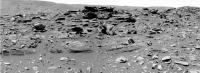
My uneducated intuition makes me think the lower, thicker layers, which seem to have large grains (small pebbles?) embedded in them, are composed of volcanic ash rather than windblown (or water-washed) fine sediments. Of course intuition is reliably wrong...
Question to the geologists: does rock formed from volcanic ash appear any different (to the instruments on Spirit) if the ash fell onto standing water, or onto dry land? Hmm, and I suppose if we imagine that there are repeated episodes of ash fall and periods under water, it will make a difference if the sediments between the water and the ash are water permeable?
Clearly there's SOMETHING different between the lower, coarse layers and the higher fine layers. What else might it be? (this is a real question, not a rhetorical.)
Posted by: aldo12xu Feb 8 2006, 10:54 PM
The Columbia Hills are older than the basaltic flows covering most of Gusev Crater.
Some of the rocks within Columbia Hills are interpreted to be clastic (eg. Peace may be a basaltic sandstone) and pyroclastic (eg. Wishtone may be a tuff) in origin. These may represent the basement rocks that were present before the Gusev impact event. With the impact event, these basement rocks were thrown up, tilted and broken up, creating brecciated rocks like Voltaire. All these units were subsequently cut by dikes, represented by basaltic rocks like Backstay and Cherry Bomb.
The plains basalts on which Spirit touched down were emplaced some time later.
Hope that helps
--Aldo--
Posted by: Shaka Feb 8 2006, 11:03 PM
http://qt.exploratorium.edu/mars/spirit/forward_hazcam/2006-02-08/2F192678390EFFAO55P1206R0M1.JPG
My uneducated intuition makes me think the lower, thicker layers, which seem to have large grains (small pebbles?) embedded in them, are composed of volcanic ash rather than windblown (or water-washed) fine sediments. Of course intuition is reliably wrong...
Question to the geologists: does rock formed from volcanic ash appear any different (to the instruments on Spirit) if the ash fell onto standing water, or onto dry land? Hmm, and I suppose if we imagine that there are repeated episodes of ash fall and periods under water, it will make a difference if the sediments between the water and the ash are water permeable?
Clearly there's SOMETHING different between the lower, coarse layers and the higher fine layers. What else might it be? (this is a real question, not a rhetorical.)
Aha! But here it is!
http://qt.exploratorium.edu/mars/spirit/micro_imager/2006-02-08/2M192678721EFFAO55P2936M2M1.JPG
And what , pray tell, is it?
If it's sandstone, I don't see any grains .
If it's scoria, I don't see any gas spaces .
If threatened with torture, if I don't talk, I would quote a Past Maestro of Home Plate" It's deja vu all over again! It's the kind of fabric Oppy has been sinking her abrasive into all over Meridiani! Smooth-lumpy STUFF!
But a geologist would phrase it more ...esoterically.

Posted by: alan Feb 8 2006, 11:26 PM
How about some color?

|
Posted by: imipak Feb 8 2006, 11:39 PM
http://qt.exploratorium.edu/mars/spirit/micro_imager/2006-02-08/2M192678721EFFAO55P2936M2M1.JPG
And what , pray tell, is it?
If it's sandstone, I don't see any grains .
If it's scoria, I don't see any gas spaces .
"Well... it's rock, isn't it?" /Arthur Dent
Actually the blueberry-esque concave dimples in the lower, whitish (in that image) material has brought the word 'slots' floating up from some dusty recess of the distant past, 18 months or more ago.
And really the darker, upper material *does* seem (to me) to be made up of sand-grains sized particles. As it happens there's an outside wall made of very soft grey-green sandstone about three feet <-- that way from my monitor that looks very like the farker material. it feels sandy if you rub your thumb over it, and there's a small heap of sand grains that have eroded out of it accumulating in tiny wind traps in the corners of wall and ground. It's a terrible building material - it weathers so fast that old older buildings in the area, there's a characteristic 'gumline' vertical profile - sort of a ' UUUUU ' shape, rotated through 90 degrees - where the mortar holding the wall together has withstood wind erosion more strongly than the building stone itself. Co-incidentally it looks a bit like the harder, then layers standing up proud of the adjacent layers, especially in the coarser-grained , thicker layers.
Anyway... I'm still boggling over the image of Homeplate being flipped over like a pancake by an impact event
Posted by: dvandorn Feb 9 2006, 01:47 AM
http://qt.exploratorium.edu/mars/spirit/micro_imager/2006-02-08/2M192678721EFFAO55P2936M2M1.JPG
And what , pray tell, is it?
If it's sandstone, I don't see any grains .
If it's scoria, I don't see any gas spaces .
...
I know I'm probably not seeing what I think I'm seeing. But it looks a little like limestone to me.
It's got this flat-smooth-plates look to it that reminds me of limestone emplaced in hot springs.
I'm probably wrong, but it's a lovely image...
-the other Doug
Posted by: jamescanvin Feb 9 2006, 02:11 AM
I haven't seen these two Pancam ESF's stitched together here yet.
|
It will be in full filter colour as soon as the data is down.
James
Posted by: DFinfrock Feb 9 2006, 02:14 AM
It's got this flat-smooth-plates look to it that reminds me of limestone emplaced in hot springs.
I'm probably wrong, but it's a lovely image...
-the other Doug
Yes, similar to what you see at Mammoth Hot Springs in Yellowstone National Park. But deposits like that don't necessarily require *hot* springs; just a source of water with a high mineral content. I have seen lots of flowstone in caves with a similar look. And those are all cold water deposits.
Now I am not suggesting that there was a cave involved. But cold water with lots of dissolved minerals would evaporate very quickly in the thin Martian atmosphere. And the fine-grained mineral deposits should build up steadily. Any sort of mineral spring, hot or cold, should be able to do the job.
David
Posted by: Bill Harris Feb 9 2006, 03:04 AM
This is a fine-grained indurated rock, and until we know the mineraoloy, that is all we can say.
One thing noteworthy: looking at Alan's RGB image of the slope at Homeplate posted today, the color of the dark toned rocks is a medium gray, with no trace of the usual ocher dust hue. Unusual because _everything_ here is dusty and itis odd to see rocks without that warm hue.
--Bill
Posted by: Shaka Feb 9 2006, 03:07 AM
snip
And really the darker, upper material *does* seem (to me) to be made up of sand-grains sized particles.
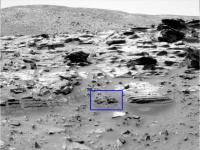
snip
If you're talking about the upper left quarter of the frame, I assume that is sand, blown onto this slab. The little yellow square represents the sort of view I assume this is (inverted, of course).
|
The actual rock seems to consist of a very-fine-grained matrix, perhaps enclosing some coarse granular clasts. Hence "smooth lumpy stuff". So much of the Meridiani evaporite had a similar look:
http://qt.exploratorium.edu/mars/opportunity/micro_imager/2004-03-07/1M131648256EFF0544P2953M2M1.JPG
Sure, the resemblance can be entirely superficial, representing entirely different constituents and origins...still...others have noted the similarity of HP and Burns Cliff on a macro scale.
 think...gotta think about it...
Posted by: RNeuhaus Feb 9 2006, 03:08 AM
|
|
According to the above picture, I still have no good idea about how these around 25 degree slope of inclination are formed. As an example, the Endurance Crater has slope due to the impact crater and we can see the cross bedding as the ones of Home Plate. My best guess is that the Home Plate was formed by the accumulation of "limestones" produces by the hot water spring over thousand years (I don't think it is build up by millions but thousands years).
But, this guess does not seem to be a strong since I cannot explain well about how the limestones were grown up if the water flush away on its borders.
Maybe, a strong explosion from the nearby volcano at about 170-200 km north west of Gusev at Latitude : 7.5°S, Longitude : 187.2°W and has 5 km of Martian daturm: a Apolinaris Patera was erupted about 3 billions years ago (Hesperian age 3.5 Billions to 1.8 Billions years) and continued intermittently throughout the Hesperian period. The Spirit landing site is located near 14.8°S, 184.6°W.
The initial effusive lava flows that formed the lower part of the dome were followed by more explosive eruptions of pyroclastic rocks and lavas to build the upper, steeper part of the structure. Depletion of the magma chamber by these eruptions or by withdrawal of the magma produced roof collapse and a large caldera. The last eruption from Apollinaris filled the caldera floor and overflowed from a narrow notch in the south wall of the crater. The above picture shows the flows of lava and probably the ash will go to toward southeast where is located the Gusev crater.
 Mars_Global_Surveyor_MOC2_838_Release.html ( 2.88K )
: 475
Mars_Global_Surveyor_MOC2_838_Release.html ( 2.88K )
: 475Thus, to explore the region of Apollinaris Patera will provide important informations on the past volcanic activity on this region of Mars, and its different phases.
Interaction between volcano and ground-ice is also visible in this region. Throughout the growth of the volcano, magmatic heating heating by dikes and other conduits, as well as by lava flows, melted ground ice within the regolith. The resulting desintegration and collapse of the terrain continued into the Late Hesperian and formed cluster of chaotic hills and mesas. Floods from Ma'adim Vallis, a large channel south of the map area, contributed to the breakup of surface rocks.
Anyone have a better explanation about the formation of HP cone?

Rodolfo
A mew update after reading the last post of DFinrock (David), I am able to explain about the formation of HP cone. Good David.
Now I am not suggesting that there was a cave involved. But cold water with lots of dissolved minerals would evaporate very quickly in the thin Martian atmosphere. And the fine-grained mineral deposits should build up steadily. Any sort of mineral spring, hot or cold, should be able to do the job.
David
Posted by: DFinfrock Feb 9 2006, 04:32 AM
Rodolfo
A new update after reading the last post of DFinfrock (David), I am able to explain about the formation of HP cone. Good David.
But as Bill noted, we shouldn't make any assumptions about the type of rock until we know the mineralogy. It sure *looks* like CACO3... but looks can be deceiving.
David
Posted by: glennwsmith Feb 9 2006, 05:43 AM
Posts have been added so rapidly here that I may seem to be fairly far downstream from an earlier post by Dvandorn regarding the almost religious awe that these images inspire in him, but I would like to second his notion -- without lending any credence to "ID" -- that it is this kind of science which for many of us best expresses our spiritual yearnings.
And yes, some of this Home Plate stuff is very remeniscent of Meridiani!
Posted by: glennwsmith Feb 9 2006, 05:46 AM
P.S. Any Teilhard de Chardin fans out there?
Posted by: deglr6328 Feb 9 2006, 06:11 AM
How come a few miniTES samples haven't been taken/shown. They would be able to rule out something like CaCO3 immediately and they only take seconds to perform. Come to think of it, I can't remember the last time a miniTES data mosaic or spectrum was released in a press release. Its still working right? Last I heard the aluminum band around the piece of KBr beamsplitter that was supposed to crack it over the winter because of mismatched termal expansions never happened.....sooo
Posted by: jamescanvin Feb 9 2006, 06:12 AM
This looks good 
748 p2272.05 36 0 0 36 2 74 pancam_Gibson_col_5_6_L257R127
Posted by: CosmicRocker Feb 9 2006, 06:37 AM
...
--Bill
Well said. It's hard to say much else at this point. The rampant speculation is unwarranted. I share in the excitement this place induces in all of us. It's amazing. But we really need more info.
Posted by: Richard Trigaux Feb 9 2006, 07:53 AM
And yes, some of this Home Plate stuff is very remeniscent of Meridiani!
I would like to second this post too. Let us forget "beliefs" and especially dogmatism (or worse). My own spiritual life also feeds on the marvels of science results, especially of space exploration.
When I was a kid, Mars was still drawn with the Schiaparelli "channels", and Titan was just a spot, I even ignored its name. I would have never dreamed to see one day a robot bringing back pictures of Mars rocks or Titan rocks...
Posted by: Richard Trigaux Feb 9 2006, 07:56 AM
Agree too. My preference goes to evaporites, but it could be something entirely new.
Posted by: Shaka Feb 9 2006, 08:37 AM
"A Rat, a Rat, my KINGDOM for a Rat!"
(Insert emoticon for royally-tormented frustration)
What would happen if we brushed and brushed and brushed this rock?
Would we eventually peel off the surface layer and see what's inside?
Or is there nothing inside - just what's on the outside, like Doug said? No grains of sand or pumice or blueberries! ?
A month ago I started off thinking - reluctantly - that HP was probably just more of the light -colored stratum we rolled across above Comanche. (Is that now a hypothesis in The Waste Basket of History ?)
Now I'm trying to mentally construct a microcosm of Meridiani Planitia in a polygonal....a....a petanque ground! And I can't do it.
...grinnnnnd...
Posted by: djellison Feb 9 2006, 08:40 AM
748 p2272.05 36 0 0 36 2 74 pancam_Gibson_col_5_6_L257R127
Yup - it's a 180 degree mosaic (after famous Negro League baseball player Josh Gibson - according to JB)
Doug
Posted by: Richard Trigaux Feb 9 2006, 08:44 AM
Did you noticed here
http://qt.exploratorium.edu/mars/spirit/micro_imager/2006-02-08/2M192681980EFFAO55P2936M2M1.JPG
the strange white zig-zag at the extreme right? It is not a cosmic ray, as it appears on two other images. It is not something shiny in the sun, as this image is in the shadow. (sometimes in this series of image it appears shiny sand grains, but not like that)
Posted by: Nirgal Feb 9 2006, 09:37 AM
...
It will be in full filter colour as soon as the data is down.
synthetic color versions already posted yesterday
but somehow "got lost" due to the board's very high posting frequency at the moment
http://mitglied.lycos.de/user73289/misc/spirit_n745_col_b.jpg
http://mitglied.lycos.de/user73289/misc/spirit_n746_col_a.jpg
Posted by: Tesheiner Feb 9 2006, 09:46 AM
Doug
6 columns usually makes for 80º, Doug.
Posted by: djellison Feb 9 2006, 10:02 AM
There's going to be 180 degrees of it once it's finished.
Trust me
Doug
Posted by: Sunspot Feb 9 2006, 10:04 AM
First good closeup of the layered rocks..unfortunately half the pic is missing.
http://qt.exploratorium.edu/mars/spirit/pancam/2006-02-09/2P192683248EFFAO55P2578L2M1.JPG
Posted by: edstrick Feb 9 2006, 10:26 AM
Pieces of a color pan arrived today, one fragment has already been posted. Here's a 3-frame pan. Bands used varied with available images, indicated in the file-name-addons, for example "257".
Hue has been adjusted to reduce ickiness of some band combinations, images contrast stretched and rather strongly sharpened.
Also that fragment of closeup pancam shot, contrast stretched and sharpened.
|
Posted by: edstrick Feb 9 2006, 10:28 AM
Oops.. forgot the second frame.
|
Posted by: edstrick Feb 9 2006, 10:47 AM
2 of the 3 color image of the edge of homeplate have matching right camera bands 2&1 color images, which result in color stereopairs.
I can't do stereo, so drool at 'm for me!
|
|
|
|
Posted by: David Feb 9 2006, 11:20 AM
I can't do stereo, so drool at 'm for me!
Thanks! You know, my eyes are getting old and I can no longer do the crossed-eyes trick as easily as I once could; being able to open and manipulate each stereo image independently (rather than as a set pair) makes the task much easier. With pre-grouped stereo pairs I usually have to sit about six feet away from the monitor to get the stereo effect, which sort of misses the point of stereo images.
Posted by: sattrackpro Feb 9 2006, 11:54 AM
We need teleportation on the next rover -
Then, we could just pick up a lot of these loose rocks and have them at JPL in 4 or 5 hours. 
Posted by: Nix Feb 9 2006, 12:04 PM
teleportation would be fine to me 
That 180° Doug mentions should be terrific...
http://www.awalkonmars.com/A1746PFCM8R751E1.jpg
btw; Nice work Nirgal!
Nico
Posted by: abalone Feb 9 2006, 12:08 PM
I can't do stereo, so drool at 'm for me!
I cant do stereo either. Try these anaglyphs
|
|
Posted by: edstrick Feb 9 2006, 01:04 PM
I *CAN'T* do stereo, Period. Not even in real life.
My left eye was never correctable better than 20:200 due to amblyopia (Lazy-eye syndrom). Not an optics problem, but optic-nerve or brain discarding the non-aligned information. Analglyphs don't work either. I can play tricks with pictures like the flicker-pair stereo, but that's all.
About 10% of the population is stereo blind, comparable to the about 10% of the male population that is red-green color blind, adn the ?1 or 2?% that has some other color deficiency.
Anyway, I'm lobbing these out there for the folks that can get the benefit of both the color and the stereo. Wheee!
Posted by: ljk4-1 Feb 9 2006, 01:10 PM
My left eye was never correctable better than 20:200 due to amblyopia (Lazy-eye syndrom). Not an optics problem, but optic-nerve or brain discarding the non-aligned information. Analglyphs don't work either. I can play tricks with pictures like the flicker-pair stereo, but that's all.
About 10% of the population is stereo blind, comparable to the about 10% of the male population that is red-green color blind, adn the ?1 or 2?% that has some other color deficiency.
Anyway, I'm lobbing these out there for the folks that can get the benefit of both the color and the stereo. Wheee!
But, Ted, just imagine if you had this kind of vision:
http://www.lileks.com/bleats/archive/06/0206/gaah.html
Perhaps some Martians did....
Posted by: Bill Harris Feb 9 2006, 01:25 PM
Thanks for the pix, Ed.
Here is today's eyebrow-raiser: with the grayscale images, I/we were thinking that the light-toned layered rocks were the native in-place rocks and that the dark-toned layered rocks were the odd ones. But these color images show or suggest that the dark gray is the native color of the layered rocks and the light tone comes from from dust or an ochre coating on the rocks. This I can easily visualize. But what bothers me is how the dark rocks got cleaned. I guess that it could be selective cleaning or sandblasting by the wind, but the selective part is the puzzle.
We'll know more on the lithology soon. IDD at work.
--Bill
Posted by: gpurcell Feb 9 2006, 02:16 PM
http://qt.exploratorium.edu/mars/spirit/pancam/2006-02-09/2P192683248EFFAO55P2578L2M1.JPG
Look at those fine, smooth layers on the face of the rock pointing to the camera. If I were on Earth, I'd think that was a water-lain sed for sure...in fact, I'd be looking for the f-word!
Posted by: RGClark Feb 9 2006, 02:39 PM
http://qt.exploratorium.edu/mars/spirit/micro_imager/2006-02-08/2M192678721EFFAO55P2936M2M1.JPG
And what , pray tell, is it?
If it's sandstone, I don't see any grains .
If it's scoria, I don't see any gas spaces .
If threatened with torture, if I don't talk, I would quote a Past Maestro of Home Plate" It's deja vu all over again! It's the kind of fabric Oppy has been sinking her abrasive into all over Meridiani! Smooth-lumpy STUFF!
But a geologist would phrase it more ...esoterically.
Great image. It has the appearance of something that flowed, then solidified.
It reminds me of some MI images taken by Opportunity in Meridiani. I suggested those in Meridiani were indications of sedimentary activity:
================================================
Newsgroups: sci.astro, alt.sci.planetary, sci.geo.geology, sci.geo.mineralogy, sci.bio.misc
From: rgregorycl...@yahoo.com (Robert Clark)
Date: 18 Mar 2004 16:26:04 -0800
Subject: Sedimentary films at Opportunity site.
I can't think of any way of producing films or crusts like these other
than through liquid water deposition or biological activity:
Microscopic Imager :: Sol 049 (14 images)
http://origin.mars5.jpl.nasa.gov/gallery/all/opportunity_m049.html
Microscopic Imager :: Sol 050 (12 images)
http://origin.mars5.jpl.nasa.gov/gallery/all/opportunity_m050.html
Bob Clark
================================================
You may need to rotate some of these images to properly view positive and negative relief.
- Bob
Posted by: RGClark Feb 9 2006, 02:46 PM
http://www.lileks.com/bleats/archive/06/0206/gaah.html
Perhaps some Martians did....
Could have warned us before hand ....
- Bob
Posted by: Tesheiner Feb 9 2006, 04:07 PM
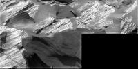
I haven't seen yet any stiching of sol 747 MIs.
So here is what I get from http://qt.exploratorium.edu/mars/spirit/micro_imager/2006-02-08/:
|
and
|
Posted by: ElkGroveDan Feb 9 2006, 04:26 PM
So here is what I get from http://qt.exploratorium.edu/mars/spirit/micro_imager/2006-02-08/:
|
|
and
|
|
That top image has some optical issues. I wonder if they are setting up a stereo sequence and you inadvertantly stitched some right and left frames together.
Posted by: Phillip Feb 9 2006, 04:59 PM
|
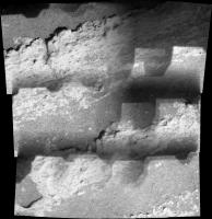
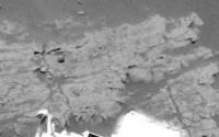
The highlighted (boxed) area is is the only example of non-planar layering I see in the HP photos so far. Does anyone see any other examples? Are my eyes/shadows playing tricks on me and these layers are in fact planar?
Phillip
Posted by: aldo12xu Feb 9 2006, 05:04 PM
Also that fragment of closeup pancam shot, contrast stretched and sharpened.
Here's a quick observation: The dark basal unit at Home Plate may not be a true stratigraphic unit. If you follow the dark colouration from left to right in the above panorama you'll notice that it becomes less intense, more diffuse and eventually disappears. This may be an alteration product related to previous burial of the outcrop, as it seems the dark colour is most intense where the soil covering is greatest.
Another point I wanted to make was that the dark coloured, rough textured zone associated with the contact between the Upper and Middle units at Burns Cliff was similarly overprinted on the stratigraphy in a somewhat discontinuous fashion. The Burns Cliff dark coloured zone was interpretted to represent the top of the former water table, where water was drawn up through capillary action, creating a secondary porosity and mineral recrystallization.
But, again, as far as Home Plate goes, it's all guess work without any mineralogical data.
Burns Cliff:
http://www.lyle.org/~markoff/pds/257/1P153661546RAD37MIP2270L257C1.JPG
http://www.lyle.org/~markoff/pds/257/1P153128119RAD37LJP2444L257C1.JPG
http://www.lyle.org/~markoff/pds/257/1P154105034RAD37MIP2275L257C1.JPG
Posted by: Zeke4ther Feb 9 2006, 05:04 PM
Thank-you! Very nice! I appreciate the anaglyph.
Posted by: malgar Feb 9 2006, 05:07 PM
Here there is the 3rd dimension!
Did you see that for MI there are 4 images for each feature? One of them is the right channel for stereo view, but the other 3 are interesting. It seems that they took the 3 images at different distances.
I have a supposition about. I know that there is an algorithm that allows to reconstruct the 3rd dimension from computing images of the same thing from different distances. Someone knows something more about this algorithm? I'm really interested in 3D from 2D algorithms! I used "shape from shading" with (partial) success on oppy outcrops.
http://www.unmannedspaceflight.com/index.php?act=Attach&type=post&id=3135
|
|
Posted by: Tesheiner Feb 9 2006, 05:08 PM
Probably yes. I just put all MI pics on autostitch (excluding those out of focus) and Stitch->Start.
Posted by: algorimancer Feb 9 2006, 06:10 PM
Did you see that for MI there are 4 images for each feature? One of them is the right channel for stereo view, but the other 3 are interesting. It seems that they took the 3 images at different distances.
I have a supposition about. I know that there is an algorithm that allows to reconstruct the 3rd dimension from computing images of the same thing from different distances. Someone knows something more about this algorithm? I'm really interested in 3D from 2D algorithms! I used "shape from shading" with (partial) success on oppy outcrops.
http://www.unmannedspaceflight.com/index.php?act=Attach&type=post&id=3135
You may be referring to the ImageJ application's Extended Depth of Field extension, available here:
http://bigwww.epfl.ch/demo/edf/index.html
Additional:
I stumbled upon a product called Helicon Focus which does a really good job of combining a stack of variably focused images into a single image in good focus:
http://www.heliconfocus.com/pages/index.php?focus_overview
Unfortunately it doesn't seem to provide a 3D reconstruction.
I encountered one or two other applications which claimed to provide a 3D reconstruction from focus information, but they were all medical related and didn't provide downloadable demos (and can also be expected to be ludicrously overpriced).
I tried using it on some MI's about a year ago, without success. I think the distance between images (depth) is too great for it.
Posted by: Shaka Feb 9 2006, 06:55 PM
Phillip
Hmmm...I'd like to see Spirit run over that a few times to see if it's in one or two pieces.
Posted by: Nix Feb 9 2006, 07:02 PM
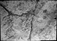
Looking in stereo I would say they're planar, the exposed part in the boxed area is bulged -eroded on all sides.
Nico
Posted by: ljk4-1 Feb 9 2006, 07:09 PM
We've just begun stepping out into the Universe and already we're planning on vandalizing it.
Posted by: RGClark Feb 9 2006, 08:04 PM
http://bigwww.epfl.ch/demo/edf/index.html
Additional:
I stumbled upon a product called Helicon Focus which does a really good job of combining a stack of variably focused images into a single image in good focus:
http://www.heliconfocus.com/pages/index.php?focus_overview
Unfortunately it doesn't seem to provide a 3D reconstruction.
I encountered one or two other applications which claimed to provide a 3D reconstruction from focus information, but they were all medical related and didn't provide downloadable demos (and can also be expected to be ludicrously overpriced).
I tried using it on some MI's about a year ago, without success. I think the distance between images (depth) is too great for it.
Cool links. This clearly would have application with clearing up the focus in some of the rover MI images.
- Bob
Posted by: Shaka Feb 9 2006, 08:44 PM
Whoops! Hey, That's what I call service with a smile:
http://qt.exploratorium.edu/mars/spirit/forward_hazcam/2006-02-07/2F192597691EFFAO55P1214R0M1.JPG
Thanks, JPL. Now if you'll just back off so we can look at the rock. Guys...?
Posted by: Tesheiner Feb 9 2006, 09:06 PM
Here is a preview of "Gibson" panorama.
|
Posted by: imipak Feb 9 2006, 09:36 PM
Yep - you're right of course. D'oh!
Looking at today's MI images (before heading here. Honest) the same thought hit me - "That is sand, you idiot!" Probably I was expecting it to be sandstone of some sort, thus was expecting to see the flat faces of grains on the surface, and then interpreted what I saw in the light of that. Not very clever!
Yes, I see what you mean, that blobby, smooth and rounded surface does look strangely familiar...
Posted by: Ames Feb 9 2006, 11:17 PM
Wow - I can see cross-bedding all over this outcrop.
This suggests a repeated process of erosion and deposition of graded material.
From what I read in the posted links there are a few specific processes that could have formed these.
1. Water - Meandering/flooding/wave action
2. Wind - Wandering of sand dunes/dust ripples
What's it to be?
http://www.ualberta.ca/~jwaldron/images/sedCD1024/11.jpg
Nick
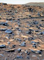
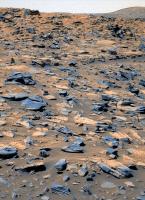
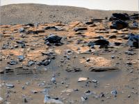
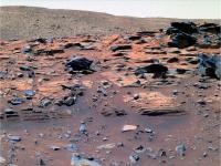
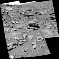
Posted by: tdemko Feb 10 2006, 12:32 AM
|
|
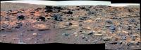
Wow, again! There is plenty of cross lamination throughout the upper, lighter unit here at Gibson. From this view, it looks like low-angle inclined lamination for the most part, with some larger-scale, higher-angle planar tabular cross bedding evident higher in the section. The lower, interbedded lighter and darker units near the base of section are also very interesting. The darker, coarser units may be local reworked volcanic debris, probably the basaltic stuff we've been seeing on the approach to Homeplate. However, the lighter, finer-grained units come in as part of a thickening-upward succession.
The low-angle and planar tabular cross stratification in the lighter upper units looks to me like what I would expect from the migration of low-relief eolian sand sheets (on earth these are called zibars) and small dune/drift foresets.
As with the Meridiani deposits, the material looks like it was originally granular sulfate. Thus, it could blow around to form cross stratification. However, again like the Meridiani deposits, it looks like there has been subsequent alteration of the granular fabric to that knobby/smooth surface texture that we see in the MI's. Maybe just slight dampening causes this material to dissolve a bit and "weld" together into a solid mass, but still have enough original sedimentary fabric to preserve ghosts of the cross stratification.
I would interpret the lower interbedded units as darker, dry sediment gravity flows, or debris flows, down the pre-Homeplate crater wall, alternating with lighter, eolian beds. It looks like eventually the lighter eolian strata dominated deposition and completed the fill sequence we see.
Some other observations/speculations:
1) the lower unit stratal boundaries are not flat...there seems to have been some original topography that was filled in by the interbedded darker and lighter units. Some of the interbedded units thicken and thin and onlap the irregular buried topography.
2) there is some suggestion of pinstripe lamination (wind ripple translatent strata) and maybe even grain flow tongues and grain fall lamina in the upper lighter unit...all good eolian strata types. Closer and/or higher resolution images will hopefully help confirm this.
3) sulfate seems to be everywhere on Mars...including original surficial/subaqueous precipitates, soil/groundwater precipitates, windblown/reworked granular material, and in situ weathering products on volcanic bedrock. It seems to me that the units here may be of the windblown/reworked variety, but subsequently altered by ground or meteoric waters.
4) there looks to be a "dropstone" in the lower interbedded unit: a darker clast imbedded in the first thick lighter unit that has deformed the bedding around it like it had dropped down vertically onto and into the unit...speculation: ejecta from a nearby impact thrown into the pre-Homeplate crater fill?
Posted by: Shaka Feb 10 2006, 12:58 AM
snip preprint scooping Steve
Hmmm.....uh huh.....okaaaayyy....Is that all?
Well then! So much for Home Plate. I guess we can leave.
On to Pitcher's Mound. What would you say that was? without looking!
Posted by: Sunspot Feb 10 2006, 01:00 AM
....hmm so your saying Dry, Dry, Dry dust and ash?? 
Posted by: tdemko Feb 10 2006, 01:38 AM
That would be my take for the original deposit. Although, I'm not sure what the original grain size may have been...dust/silt or sand. I haven't yet got my earth-centric mind wrapped around Martian atmospheric pressures, wind speeds, and gravity and how they affect sediment transport. From what we've seen so far, it doesn't look like there are any features that had to have been water lain. However, I think that there was a subsequent groundwater/meteoric water-mediated alteration event to lithify the eolian material.
Posted by: Bill Harris Feb 10 2006, 02:21 AM
Not many of us have.
Many of the aeolian erosional/depositional processes here are similar to what we see on Earth, but the thing to get accustomed to is that things act for a long, long time on Mars. Millions or billions of years are probably the equivalent timeframes compared to thousands of Earth years.This is truly an alien environment.
--Bill
Posted by: RNeuhaus Feb 10 2006, 02:48 AM
These slabs does not look so strong as ones rock from Earth and these must be fragil and they can be broken by the hand pressure since these are of aeolian and sulfate material.
Besides, the Mars environment is, very probably, a virgin, no any strange have alterated it except to the natural forces such as the aeolian process, mass movement by the gravity, volcanic process, tectonic process, impact craters, and hydroproces. No one animal, alien or any kind of civilization had ever alterated any Martian landscape. Up to know, any visible incident. Still curious.
Last hope would be of any small, and microscopic rock alteration by lietchein.
Rodolfo
Posted by: jamescanvin Feb 10 2006, 04:13 AM
|
|
It will be in full filter colour as soon as the data is down.
James
And here is my attempt at colour for this (using the slightly odd filter combination L347).
http://www.physics.usyd.edu.au/~jcanvin/mer/index.html#A0746


Posted by: CosmicRocker Feb 10 2006, 07:43 AM
...
Thanks for that insightful analysis. You offer so many thoughts that I'm not sure where to begin to ask questions. A "thickening-upward succession" is something I hadn't previously considered, but it surely fits with what we are seeing. I can see the wind-blown nature of the cross-lamination, and that recrystallization of soluble sufate clasts is a good way to make textures like those we are seeing here.
I'm still questioning the regional relationship of HP to it's surroundings. I'm not yet convinced this is a crater, though I surely wouldn't rule that out.
Posted by: tty Feb 10 2006, 08:23 AM
It sure does look like a dropstone. Question: have you ever seen such a clear dropstone structure in an eolian deposit? I can only remember seeing them in waterlaid sediments.
Wild speculation: Could this be a rhythmite and a "real" dropstone? A lake in Gusev would certainly have had a water regime that varied strongly with the seasons and ice-floes are highly likely too.
tty
Posted by: Nirgal Feb 10 2006, 09:55 AM
James: nice color composites, as usual
here is a preview of the "Gibson" close-up panorama
in synthetic false colors from L7 frame only ...
until the multi-filter colse-ups come in
http://mitglied.lycos.de/user73289/misc/spirit_p747_col_b.jpg
Posted by: abalone Feb 10 2006, 10:52 AM
Like the sea cliffs around Sydney, even if its only a meter tall

|
Posted by: Bill Harris Feb 10 2006, 10:57 AM
Indeed. Most of us have been so focused with our industry-related pursuits that we haven't thought about such things since Geomorph 101 decades ago.
I'm tending to think dry, dry, dry aeolian with damp alteration. I wish that I/we knew more about those light-toned layered outcrops we saw on the way here, and especially the homeplate-like outcrop that was on the hill just outside of the "Ultreya basin". We need to link these wonderfully laminated beds to outcrops within the Inner Basin. I think I see more of that on McCool Hill and suppose she'll visit during the winter wander.
>dropstone
***I speculate that it simply _looks_ like dropstone. Remember that this is a fine-grained rock that has been gently sandblasted for millions of years.***
--Bill
EDIT: oops, I was thinking of something else. It _does_ look like a dropstone.
"Never Mind..."
PS-- new L7/R1 Pancams are up: http://qt.exploratorium.edu/mars/spirit/pancam/2006-02-10/
Posted by: SigurRosFan Feb 10 2006, 11:30 AM
Very nice, James. Here's a quick new rover view.
If you don't object ...
Spirit on Sol 746: 
Posted by: Bob Shaw Feb 10 2006, 12:20 PM
Yes, *something* must have persuaded the dusty stuff to turn solid, whether or not the original deposition was into water or a smidgeon of water came later. In any case, nice tasty acidic water, loaded with salts would bind the essentially zero-strength debris into layered rock (and, once the water dries out the mineralised outer skin would be tough, until eroded away and the softer interiors revealed). Perhaps a test would be to look for a physically cracked-open rock which has been preserved from weathering by some chance and to examine the 'inside' vs the 'outside....
Bob Shaw
Posted by: Tesheiner Feb 10 2006, 12:30 PM
This panorama should be quite impressive at the end!
Currently almost all of sol 748's 6x3 frames have been downlinked -- L7R1 only, the "color" should be waiting on the priority queue -- and more shots are planned for tosol.
749 p2274.05 66 0 0 66 2 134 pancam_gibson_left_11_pos_L257R127
Doug, I guess "a little bird" told you about it.
Another "preview" (at half-size).
|
Posted by: ljk4-1 Feb 10 2006, 12:38 PM
Currently almost all of sol 748's 6x3 frames have been downlinked -- L7R1 only, the "color" should be waiting on the priority queue -- and more shots are planned for tosol.
749 p2274.05 66 0 0 66 2 134 pancam_gibson_left_11_pos_L257R127
Doug, I guess "a little bird" told you about it.
Another "preview" (at half-size).
|
|
What is that strange, two-toned box on the right side of the image?
Assuming Spirit retains its Energizer Bunny status, where are they planning on having it explore after Home Plate?
Posted by: Sunspot Feb 10 2006, 12:59 PM
I guess if the prelimenary results dont show any evidence for water in the formation of these rocks they wont stop at HP long....
Posted by: tdemko Feb 10 2006, 02:02 PM
Wild speculation: Could this be a rhythmite and a "real" dropstone? A lake in Gusev would certainly have had a water regime that varied strongly with the seasons and ice-floes are highly likely too.
tty
I think that is a great alternative explanation. My first thought on the lower interbedded unit was that it looked like rhythmic/episodic lake beds. With some of the recent ideas about low-latitude glaciation on Mars, it would not be hard to visualize the pre-Homeplate crater as containing ice and a subglacial lake.
The closest to an eolian "dropstone" I've ever seen was a large (5-6 cm diam), rounded, polished, quartzite pebble embedded in dune foresets the Jurassic Navajo/Page eolian sandstone in Utah on the Colorado Plateau. However, the likely interpretation of that clast was that it was a dinosaur "gizzard stone" and I'm not sure we want to go there for Gusev.....!
Posted by: SigurRosFan Feb 10 2006, 02:57 PM
http://www.space.com/missionlaunches/060210_spirit_home_plate.html - Spirit Mars Rover Reaches 'Home Plate': Formation Has Researchers Puzzled
--- For his part, Crumpler said that he refuses to accept one spectacular interpretation: "Namely, that it is a volcanic vent structure." Crumpler said more detailed rover images are needed.
Currently these include such possibilities as playa, exhumed crater floor filled with typical Columbia Hills layered deposits, a tuff cone or maar, and a hydrothermal vent area, Crumpler noted. "In fact, it is a healthy debate within the team right now." ---
Posted by: ljk4-1 Feb 10 2006, 02:59 PM
--- For his part, Crumpler said that he refuses to accept one spectacular interpretation: "Namely, that it is a volcanic vent structure." Crumpler said more detailed rover images are needed.
Currently these include such possibilities as playa, exhumed crater floor filled with typical Columbia Hills layered deposits, a tuff cone or maar, and a hydrothermal vent area, Crumpler noted. "In fact, it is a healthy debate within the team right now." ---
Just imagine if steam were seen coming out from under one of the rocks....
Posted by: ustrax Feb 10 2006, 03:39 PM
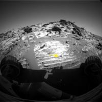
Hey...Is that a shiny perfect spherule right in front of Spirit?...
Posted by: Marz Feb 10 2006, 03:40 PM
I'd imagine the mossbaur results will help reduce the number of theories, but it's nice to see that everyone's speculation is still in the realm of possibilities. Is the spectrometer requiring more than a 3-day soak time? Does such a long sample introduce noise that confuses the results?
Posted by: djellison Feb 10 2006, 03:43 PM
I dont believe it adds noise - but depending on Iron content, a Mossbauer Spectrum could take 3 days - perhaps even longer.
The APXS is still fairly sharp - much longer half-life on its source.
Doug
Posted by: tty Feb 10 2006, 03:46 PM
The closest to an eolian "dropstone" I've ever seen was a large (5-6 cm diam), rounded, polished, quartzite pebble embedded in dune foresets the Jurassic Navajo/Page eolian sandstone in Utah on the Colorado Plateau. However, the likely interpretation of that clast was that it was a dinosaur "gizzard stone" and I'm not sure we want to go there for Gusev.....!
I didn't think of the subglacial angle, but that is a very sensible idea. I've seen subglacial rhythmites in Norwegian caves which looked much like this.
I don't quite buy the indurated-sulphates idea. Morphologically this formation practically screams "harder than surrounding rocks", which does not fit with the softness of the Meridiani sulphates.
tty
Posted by: Sunspot Feb 10 2006, 04:04 PM
How did this formation become so localised? We havent seen anything else even remotely similar in Gusev - we are seeing totally different rock types appearing at the end of a drive compared to the start - 20/30m. If it is some kind of volcanic related event, wouldn't that cover a huge area?
Posted by: ljk4-1 Feb 10 2006, 04:18 PM
Probably has been said before, but what the hey: Could Home Plate be a large chunk of rock blown out by either a volcano or meteorite impact from far away?
Can we determine from orbital images and spectral data where it might have come from, going on this idea?
Posted by: Ames Feb 10 2006, 04:18 PM
Oh Yeh...
|
Posted by: SigurRosFan Feb 10 2006, 05:06 PM
Posted by: algorimancer Feb 10 2006, 05:56 PM
Perhaps not hematite, but it could easily be a cementation. It does look distinctly spherical. Here's a cross-eyed stereo perspective on it:

|
Interestingly, it seems to be lying in the center of a shallow circular pit. Possibly coincidence.
Here's a close-up:

|
The more I look at that close-up, the more interesting this thing becomes. Between the ball and the edge of the circular pit there are at least two distinct circular lineations. There must be a really nice geological term for this, but I don't know it.

|
Factoring in the rings surrounding the sphereoid, I think that there is no real doubt that this is in fact a cementation (concretion?), similar to the blueberries at Meridiani, but I suspect of a different composition. I've seen similar concretions in sandstone underlying limestone in central Texas. Further, to the best of my knowledge these things require water to form (at least dampness), so presumably this says something about the local geological history.
Posted by: Shaka Feb 10 2006, 06:04 PM
snip
>dropstone
***I speculate that it simply _looks_ like dropstone. Remember that this is a fine-grained rock that has been gently sandblasted for millions of years.***
--Bill
EDIT: oops, I was thinking of something else. It _does_ look like a dropstone.
"Never Mind..."
PS-- new L7/R1 Pancams are up: http://qt.exploratorium.edu/mars/spirit/pancam/2006-02-10/
Hey, Guys, share the wealth! Can somebody put an arrow on a picture showing this "dropstone"? This would be my first on Mars!
Posted by: Shaka Feb 10 2006, 06:18 PM
Currently almost all of sol 748's 6x3 frames have been downlinked -- L7R1 only, the "color" should be waiting on the priority queue -- and more shots are planned for tosol.
749 p2274.05 66 0 0 66 2 134 pancam_gibson_left_11_pos_L257R127
Doug, I guess "a little bird" told you about it.
Hey, Tesh, does your portal into the secret codes tell you if some spectrometry has been started yet? That seems to be the key missing puzzle piece.
Posted by: tdemko Feb 10 2006, 06:26 PM
It's right about dead center in this view, deforming the 3rd light layer from the base in the succession here:
http://marsrovers.jpl.nasa.gov/gallery/all/2/f/746/2F192597691EFFAO55P1214R0M1.JPG
It looks like it may have "dropped in" sometime after deposition of the 4th light layer...the "crater" it left is filled with some disrupted material, and it isn't until several layers later that they continue over it.
Posted by: Shaka Feb 10 2006, 06:41 PM
http://marsrovers.jpl.nasa.gov/gallery/all/2/f/746/2F192597691EFFAO55P1214R0M1.JPG
It looks like it may have "dropped in" sometime after deposition of the 4th light layer...the "crater" it left is filled with some disrupted material, and it isn't until several layers later that they continue over it.
OH Yessss! 'Cause the light layer curves under it. Of course!
Thank you, Doctor. We do have fun in this forum, but having a professional along makes things so much clearer!
Tell me, what would you say are the key issues that need to be investigated now at HP?
Does PM offer other enticing questions?
Posted by: Steve Feb 10 2006, 07:17 PM
The APXS is still fairly sharp - much longer half-life on its source.
Doug
Assuming the false counts and electronic noise are at a constant level, while the CO57 intensity is declining at a 271.8 day / 264.5 sol half life, the signal to noise ratio on the Mössbauer should be decreasing.
Since you raised the issue, what is the isotope (and its half-life) for the APXS?
Steve
Posted by: odave Feb 10 2006, 07:21 PM
From the http://www.unmannedspaceflight.com/index.php?showtopic=1649&view=findpost&p=26282 transcription...
Doug: That's probably not going to be a problem!
Steve: <laughs> I don't anticipate havin' a problem with that one.
EDIT: Wikipedia gives Curium-244's half-life as 18.1 years
Posted by: dilo Feb 10 2006, 08:44 PM
Sol748, NavCam...
|
|
South view, now with complete McCool hill.

|
East view.
Posted by: Richard Trigaux Feb 10 2006, 09:43 PM
Have you seen http://qt.exploratorium.edu/mars/spirit/pancam/2006-02-10/2P192769737EFFAO55P2271L7M1.JPG (bottom right)
It looks like the flat surface of a strata (seen fom above). But it is not exactly flat... if looks like a soft or molten surface which was hardened after.
What is it?
surface of lava flow?
Mud? But if so, disturbed by what?
Posted by: Tesheiner Feb 10 2006, 09:57 PM
The "portal into the secret codes" may be yours too.
http://marswatch.astro.cornell.edu/merweb/merweb.pl
Select a rover (MER-A=Spirit, MER-B=Opportunity), then the sol(s) of your choice and click on "Detailed report". Look under section "4. What EDRs did we request?" for the planned sequences. Among others, we have:
749 p1121.03 2 0 2 0 0 4 front_haz_idd_apxs_doc_512x512x1_bpp_high
I read that as fhaz images to "document" the ongoing work of an instrument, in that case the Mossbauer and APXS spectrometers.
Posted by: Shaka Feb 10 2006, 10:18 PM
http://marswatch.astro.cornell.edu/merweb/merweb.pl
Select a rover (MER-A=Spirit, MER-B=Opportunity), then the sol(s) of your choice and click on "Detailed report". Look under section "4. What EDRs did we request?" for the planned sequences. Among others, we have:
wwwwwooooooooowwwwww! It works. And I didn't even have to enter a MySQL query! I don't even have to know what a MySQL query IS! I have god-like POWER!!!
HeHe, just wait till that bully kicks sand on me next time.
The name is Bond...James Bond.
Posted by: Nirgal Feb 10 2006, 11:11 PM
|
|
South view, now with complete McCool hill.
very impressive view, dilo !
gives a real sense of standing there looking up at the Cool Summit
Posted by: Shaka Feb 10 2006, 11:43 PM
It looks like the flat surface of a strata (seen fom above). But it is not exactly flat... if looks like a soft or molten surface which was hardened after.
What is it?
surface of lava flow?
Mud? But if so, disturbed by what?
What would you see if you buried one of the common laminated rocks from the slope, so that its top surface was exactly parallel and flush with the sand surface? After a million years or so of the wind and sand eroding it, would it look different from this?
The edges of the rock layers erode at different rates, producing their complex shapes. Would not the top surface also erode at different rates, producing an uneven surface, with the low areas filling with sand, as here?

Posted by: Bob Shaw Feb 11 2006, 12:05 AM
I don't quite buy the indurated-sulphates idea. Morphologically this formation practically screams "harder than surrounding rocks", which does not fit with the softness of the Meridiani sulphates.
tty
When water-saturated sandstone is cut after quarrying, the water migrates toward the cut surfaces bearing a variety of dissolved salts etc. The outer surface 'mineralises' and forms a hard sheath around the soft, though still consolidated, interior. Obviously, all the bedding etc is preserved.
Now, switch to Mars - different materials, same process. But add hundreds of millions of years of aeolian erosion, and the odd impact or muddy flood.
So, you end up with a degraded formation, with rather variable material strengths, leading to stranger than even the usually strange shapes that ventifacts enjoy!
The original deposition could be ashfall, dunes, or whatever, possibly into a pre-existing crater (as in the famous exhumed braided channels which are now exposed as ridges, their water-altered materials being harder than the surroundings).
Bob Shaw
Posted by: CosmicRocker Feb 11 2006, 02:01 AM
...
Good observation, Richard. I have been looking so carefully at the bedding in vertical sections that I didn't even notice that bedding plane staring me in the face. It's an important view, but I need to stare back at it for a while.
Posted by: nprev Feb 11 2006, 03:27 AM
Very interesting "squiggly" forms on the base rock at about 7o'clock from the flat rock in this shot. Limestone, just maybe?
Posted by: CosmicRocker Feb 11 2006, 06:30 AM
wwwwwooooooooowwwwww! It works. And I didn't even have to enter a MySQL query! I don't even have to know what a MySQL query IS! I have god-like POWER!!!
HeHe, just wait till that bully kicks sand on me next time.
The name is Bond...James Bond.
OK, so who was it who bestowed the secret, "god-like POWER" on Shaka? You may live to regret it.
On a more serious note, I've been meaning to dig up an image for dvandorn ever since he first mentioned the "G" word a while back. The dropstone discussion reminded me I hadn't done that. I think it was shortly after Spirit left the summit when she took some pancams on sol 642. When I saw this one, my first thought was "moraine." I have some problems imagining significant glacial transport in Gusev crater, but that view from near the summit still makes me wonder.
http://marsrovers.jpl.nasa.gov/gallery/all/2/p/642/2P183361655EFFAI38P2390R1M1.HTML
It took me a while to find a decent earthly analogy, but imagine this scene after removing all of the ice.
http://www.wonko.info/blackandwhite/new/moraine.jpg
Regarding the "dropstone," such a thing would be amazing, but it sure would be nice to see that feature with one of the narrower-angle cameras. They are taking MIs so near it, maybe we can hope. I'm not sure it would be visible to the Nav/Pan cams. It's not obvious that the dark clast is actually embedded in that layer. It could be a fortuitous arrangement of a piece of float on an anomalous area. If you follow those lower layers laterally, they do display a lot of lateral thickening, thinning, and bending.
Posted by: Myran Feb 11 2006, 01:25 PM
I would be extremely suprised if we found any limestone, remember the theory of acidic water on Mars? It based on two thing mots importanly the sulphur salts found and the second as a way explaining the absence of limestone. With sulphuric acid lakes and oceans, no limestone would ever form. Well that's at least one theory, but fact remains, we've sent several detectors to search from orbit but found none.
Posted by: Bill Harris Feb 11 2006, 01:49 PM
Conversely, if limestone, CaCO3, did form and acidic conditions later developed, it would form gypsum, CaSO4 and CO2. The components don't disappear, they get rearranged...
--Bill
Posted by: Steve Feb 11 2006, 05:42 PM
I was just looking at this image http://qt.exploratorium.edu/mars/spirit/pancam/2006-02-10/2P192770128EFFAO55P2271L7M1.JPG and was struck by the clear fractures running across the strata. In several cases you can clearly see the matches between the left and right halves of the fracture.
Does anyone have any hypotheses about the kinds of processes that could have produced these fractures without widely dipersing the fragments?
Posted by: Richard Trigaux Feb 11 2006, 07:52 PM
hmmmmm...
I don't think that sulphuric acid by itself forbad limestone to form.
Acids, sulphuric or carbonic, are bound to reacts with iron, calcium, sodium, etc... to form sulphates or carbonates.
If sulphuric acid or carbonic acid (the later in the form of carbon dioxyd) accumulated, it is because they did not found anything to react with.
In clear, there was not enough calcium to form limestone, the very few calcium available was "used" to form gypsum (sulphuric acid being stronger than carbonic acid).
And why only very few calcium? likely because the marsian crust is not differentiated, formed only of basalt, with very few turn-over by mantellic convection (no plate tectonics). Certainly there is as much calcium on Mars than on Earth, but on Earth the calcium dispersed into the mantle was brough to the surface by a massive mantellic convection, and it accumulated into differentiated rocks such as granites (the core of the continents) and was thus made available on the surface by an erosion which groung million more times rocks than on Mars. Even carbonatite lava can form directly from very differentiated magmas.
The same would apply on Venus, and it allowed carbon dioxyd to accumulate on the surface without being fixed in the form of limestone (until the greenhouse effect arouse the temperature so high that now it is impossible to form limestone).
Posted by: Shaka Feb 11 2006, 08:12 PM
Does anyone have any hypotheses about the kinds of processes that could have produced these fractures without widely dipersing the fragments?
Hypthesis #1: As surrounding support material (crater wall? outer extent of broad strata?) is removed, rigid strata of HP sag and fracture.
Hypothesis #2: Shock waves from impacts in surrounding area fracture HP strata.
Hypothesis #3: Other local tectonic stresses (e.g. implacement of plains lavas) fracture HP strata.
Hypothesis #4: Combine the forces of Hypotheses 1-3 in any desired combination.
Name your poison.
and I'm not even a geologist.
Posted by: imipak Feb 12 2006, 03:12 AM
Does anyone have any hypotheses about the kinds of processes that could have produced these fractures without widely dipersing the fragments?
I wondered about the effects of thermal cycling over such long periods of time. Presumably such processes would only be felt on the exposed surfaces, though, so it can't account for such deep fractures. (Sun exposure could heat the surface, but most of the heat would be rapidly conducted away into the cold body of the rock; the steepest temperature gradient would then be in the outmost layer of an exposed rock.)
What about impact shockwaves? Bedrock that was far enough from the site of the impact not to be thrown up / out as part of the ejecta blanket could still be jolted enough to shatter, like a jigsaw puzzle when a heavy book is dropped on the table. But then, my usually reliably wrong intuition says that rocks would split along the bedding planes , rather than perpendicularly. Unless the impact was almost vertically overhead, perhaps? Hmm, that would fit the theory of HP being the exposed base of an impact crater after all the surrounding material's eroded away.
The only other thing that occurs to me is gravity. As the lower (softer?) layers are eroded faster that the upper layers, small overhangs develop; eventually the weight fractures the parent rock and a chunk drops off (or just detaches slightly, with it's slide downhill slowed by windblown sand deposits?) It's interesting to note that in the really specacularly eroded blocks, although almost every layer seems to have eroded at a slightly different rate from the adjoining layers, there are no overhangs longer than, perhaps a couple of cm. (It looks that way to my untrained eye, but after confusing sand and rock the other day, I've now learned to mistrust almost everything I think I see in the images, including scale
)
Posted by: CosmicRocker Feb 12 2006, 06:29 AM
Everything we've seen on Mars is so busted up, it's really not suprising to find more. I think the answer is "all of the above," and then some. Faults, fractures, and joints are pretty ubiquitous in rocks on Earth. They seem to be even more common on Mars, but we need to remember that the Martian rocks we are seeing are mostly as old as the oldest (and quite rare) rocks still preserved on Earth. Current temperature min/max ranges on Mars are also much greater than on earth, and we don't know much about how those ranges may have changed over time. The paucity of water to aid in the healing of wounds probably also plays a role. These rocks almost certainly have experienced noticeable vibrations from numerous nearby impact events as well.
I'm not sure which particular fracture Steve had in mind when he posted his question, but I think it would be a difficult one to answer conclusively.
The really cool thing about the MER missions has been the way they have forced all geoscientists and geo-enthusiasts to reconsider previous conceptions. Even when new imagery is slow to come down, there is yet so much to to think about from "sols old" imagery!
Posted by: Sunspot Feb 12 2006, 11:45 AM
Damn .. exploratorium must be down, no pics from either rover.
Posted by: djellison Feb 12 2006, 11:50 AM
Nothing at the JPL site either - probably something broken at JPL - I'm sure they'll fix it ASAP
Doug
Posted by: Sunspot Feb 12 2006, 03:06 PM
Some of yesterdays pics from Spirit are on the ground according the the tracking website but not on exploratorium yet.... also, no pics have arrived today (sol 730) from Opportunity, maybe an early morning pass? ....somethings up.
Posted by: Steve Feb 12 2006, 04:00 PM
As I read the Spirit listing, as of a few minutes ago, there have only been 5 MI full frames downloaded since SOL 749. Everything else is only down as thumbnails.
Actual number of EDRs by sequence number and image type:
Sol Seq.Ver ETH ESF EDN EFF ERP Tot Description
--- -------- --- --- --- --- --- ---- -----------
749 p1121.03 2 0 0 0 0 2 front_haz_idd_apxs_doc_512x512x1_bpp_high
...
750 p2936.02 1 0 0 1 0 2 mi_cover_open_minloss2_LUT3_pri44
750 p2936.02 1 0 0 1 0 2 mi_cover_open_minloss2_LUT3_pri44
750 p2936.02 0 0 0 0 0 0 mi_cover_open_minloss2_LUT3_pri44
750 p2936.02 1 0 0 1 0 2 mi_cover_open_minloss2_LUT3_pri44
750 p2936.02 1 0 0 1 0 2 mi_cover_open_minloss2_LUT3_pri44
750 p2936.02 1 0 0 1 0 2 mi_cover_open_minloss2_LUT3_pri44
...
Total 239 0 0 5 0 244
Posted by: Sunspot Feb 12 2006, 04:05 PM
An Odyssey relay problem perhaps?
Posted by: alan Feb 12 2006, 05:06 PM
Minites, mossbauer, apxs may be using all the bandwidth.
Posted by: OWW Feb 12 2006, 05:30 PM
Maybe Odyssey went into safe mode again, just like last year. As I recall, it took about a week before it was fixed.
Posted by: djellison Feb 12 2006, 05:51 PM
MB and APXS are tiny tiny data products..genuinely miniscule compared to say, a single Pancam frame.
You average Pancam frame, uncompressed, is 8 Mbits once downed to 8 bit from 12 - and that comes out at about 2 Mbytes on the PDS.
Full APXS spectrum on the PDS is 218kb (so perhaps 0.8 Mbits uncompressed on the rover - likely a lot less)
A full TES spectrum is about 125kb (so perhaps 0.4 mbits?)
The tracking page says they have 750 imagery on the ground, and given that it's only 751.5 at the moment ( and you don't get imagery from any one sol till about Sol X.7 - X.9 ) - so I think that imagery is coming down from a healthy Spirit at least.
It's very very likely a problem with the scripts that put the raw imagery online - and being a weekend, I cant imagine it being a priority.
Doug
Posted by: Steve Feb 12 2006, 06:19 PM
It's very very likely a problem with the scripts that put the raw imagery online - and being a weekend, I cant imagine it being a priority.
Doug
Let a newbie rush in with a naive comment.
The tracking page still says that the only images on the ground from sols 749 and 750 are 5 MI frames from sol 750 and 239 thumbnails. It seems that there is a real bottleneck somewhere between Spirit and Cornell; I leave it to those who know the data paths to guess where.
Steve
Posted by: Shaka Feb 12 2006, 06:23 PM
While we're bemoaning glitches, my UMS list of topics showed "new replies" icons in the left column for all the visible threads. Imagine my frustration and disappointment when there were only new replies for two topics. ...sigh... no pictures and it's Sunday...a week ago we were agog over HP...now what should we do?
[i]I spy with my little eye something blue...[i]
Shoot...now I can't make the italics work...HEY, somebody changed the page format...What's going on here?
Dam', just when I thought I had the crest of the learning curve...I'm going back to bed....
Posted by: djellison Feb 12 2006, 06:37 PM
Shoot...now I can't make the italics work...HEY, somebody changed the page format...What's going on here?
Dam', just when I thought I had the crest of the learning curve...I'm going back to bed....
You didnt use ...
So nothing's changed.
The easier way is to hit the I button, type your italic text, then hit it again. Or, type it all, select the I text, then click I. ORrrrr go into 'My Controls' and turn on WYSIWYG editing
The board has been upgraded if you check the forum update section.
Doug
Posted by: Sunspot Feb 12 2006, 10:33 PM
....still no new pics from either rover, but as Doug suggested, might be some problem this end, cant see both rovers having a problem at exactly the same time.
Posted by: CosmicRocker Feb 13 2006, 12:23 AM
Sol 751 is almost over and no Spirit EDR's from any sol have been received on the ground. For Opportunity sol 730 is over, and no EDR's were received. I normally don't pay a lot of attention to the downlink times, but doesn't this seem a bit anomalous?
Posted by: Sunspot Feb 13 2006, 12:32 AM
I dont think anything from sol 750 made it onto exploratorium? However, there is 1 image, from the MI on the JPL RAW page from sol 750.
Posted by: djellison Feb 13 2006, 08:53 AM
We've had, what, half a dozen, a dozen times when no images arrived on Exp or JPL in the last two years for a day or two. Only once was it an actual problem with Odyssey, the rest of the time it was just problems with the servers and the scripts that do it. I've checked the same site that shows the Relay schedules, and there's nothing out of the ordinary uplinked to Odyssey recently - and there was some obviously titled uplinks during that last safe mode problem.
However - it might be an Odyssey problem, I just think a server problem is more likely.
Doug
Posted by: Sunspot Feb 13 2006, 09:43 AM
Looking at the data tracking site, the observations planned for Spirit on sol 752 are identical to those planned for Opportunity on Sol 731.
Sol Seq.Ver ETH ESF EDN EFF ERP Tot Description
--- -------- --- --- --- --- --- ---- -----------
752 http://marswatch.astro.cornell.edu/merweb/merweb.pl?rover=A&sol=1&test=ops&instrument=all&choice=SQL&querytext=SELECT%20t1.FullPath%20FROM%20EDRLevel%20AS%20t1,%20DataProductLevel%20AS%20t2%20WHERE%20t1.ParentProductID%20=%20t2.ProductID%20AND%20t2.ObsID%20=%20%27A%20%20%20%20%20%20%20%20%20%20%20%20ops752p263101%201%27%20ORDER%20BY%20t1.FullPath http://marswatch.astro.cornell.edu/merweb/merweb.pl?rover=A&sol=1&test=ops&instrument=all&choice=SQL&querytext=SELECT%20t1.FullPath%20FROM%20EDRLevel%20AS%20t1,%20DataProductLevel%20AS%20t2%20WHERE%20t1.FileTypeCode%20=%20%27ETH%27%20AND%20t1.ParentProductID%20=%20t2.ProductID%20AND%20t2.ObsID%20=%20%27A%20%20%20%20%20%20%20%20%20%20%20%20ops752p263101%201%27%20ORDER%20BY%20t1.FullPath http://marswatch.astro.cornell.edu/merweb/merweb.pl?rover=A&sol=1&test=ops&instrument=all&choice=SQL&querytext=SELECT%20t1.FullPath%20FROM%20EDRLevel%20AS%20t1,%20DataProductLevel%20AS%20t2%20WHERE%20t1.FileTypeCode%20=%20%27ESF%27%20AND%20t1.ParentProductID%20=%20t2.ProductID%20AND%20t2.ObsID%20=%20%27A%20%20%20%20%20%20%20%20%20%20%20%20ops752p263101%201%27%20ORDER%20BY%20t1.FullPath http://marswatch.astro.cornell.edu/merweb/merweb.pl?rover=A&sol=1&test=ops&instrument=all&choice=SQL&querytext=SELECT%20t1.FullPath%20FROM%20EDRLevel%20AS%20t1,%20DataProductLevel%20AS%20t2%20WHERE%20t1.FileTypeCode%20=%20%27EDN%27%20AND%20t1.ParentProductID%20=%20t2.ProductID%20AND%20t2.ObsID%20=%20%27A%20%20%20%20%20%20%20%20%20%20%20%20ops752p263101%201%27%20ORDER%20BY%20t1.FullPath http://marswatch.astro.cornell.edu/merweb/merweb.pl?rover=A&sol=1&test=ops&instrument=all&choice=SQL&querytext=SELECT%20t1.FullPath%20FROM%20EDRLevel%20AS%20t1,%20DataProductLevel%20AS%20t2%20WHERE%20t1.FileTypeCode%20=%20%27EFF%27%20AND%20t1.ParentProductID%20=%20t2.ProductID%20AND%20t2.ObsID%20=%20%27A%20%20%20%20%20%20%20%20%20%20%20%20ops752p263101%201%27%20ORDER%20BY%20t1.FullPath http://marswatch.astro.cornell.edu/merweb/merweb.pl?rover=A&sol=1&test=ops&instrument=all&choice=SQL&querytext=SELECT%20t1.FullPath%20FROM%20EDRLevel%20AS%20t1,%20DataProductLevel%20AS%20t2%20WHERE%20t1.FileTypeCode%20=%20%27ERP%27%20AND%20t1.ParentProductID%20=%20t2.ProductID%20AND%20t2.ObsID%20=%20%27A%20%20%20%20%20%20%20%20%20%20%20%20ops752p263101%201%27%20ORDER%20BY%20t1.FullPath http://marswatch.astro.cornell.edu/merweb/merweb.pl?rover=A&sol=1&test=ops&instrument=all&choice=SQL&querytext=SELECT%20t1.FullPath%20FROM%20EDRLevel%20AS%20t1,%20DataProductLevel%20AS%20t2%20WHERE%20t1.ParentProductID%20=%20t2.ProductID%20AND%20t2.ObsID%20=%20%27A%20%20%20%20%20%20%20%20%20%20%20%20ops752p263101%201%27%20ORDER%20BY%20t1.FullPath pancam_sky_spot_L234567R34567
752 http://marswatch.astro.cornell.edu/merweb/merweb.pl?rover=A&sol=1&test=ops&instrument=all&choice=SQL&querytext=SELECT%20t1.FullPath%20FROM%20EDRLevel%20AS%20t1,%20DataProductLevel%20AS%20t2%20WHERE%20t1.ParentProductID%20=%20t2.ProductID%20AND%20t2.ObsID%20%20IN%20%28%27A%20%20%20%20%20%20%20%20%20%20%20%20ops752p263101%201%27%20%29%20ORDER%20BY%20t1.FullPath http://marswatch.astro.cornell.edu/merweb/merweb.pl?rover=A&sol=1&test=ops&instrument=all&choice=SQL&querytext=SELECT%20t1.FullPath%20FROM%20EDRLevel%20AS%20t1,%20DataProductLevel%20AS%20t2%20WHERE%20t1.FileTypeCode%20=%20%27ETH%27%20AND%20t1.ParentProductID%20=%20t2.ProductID%20AND%20t2.ObsID%20%20IN%20%28%27A%20%20%20%20%20%20%20%20%20%20%20%20ops752p263101%201%27%20%29%20ORDER%20BY%20t1.FullPath http://marswatch.astro.cornell.edu/merweb/merweb.pl?rover=A&sol=1&test=ops&instrument=all&choice=SQL&querytext=SELECT%20t1.FullPath%20FROM%20EDRLevel%20AS%20t1,%20DataProductLevel%20AS%20t2%20WHERE%20t1.FileTypeCode%20=%20%27ESF%27%20AND%20t1.ParentProductID%20=%20t2.ProductID%20AND%20t2.ObsID%20%20IN%20%28%27A%20%20%20%20%20%20%20%20%20%20%20%20ops752p263101%201%27%20%29%20ORDER%20BY%20t1.FullPath http://marswatch.astro.cornell.edu/merweb/merweb.pl?rover=A&sol=1&test=ops&instrument=all&choice=SQL&querytext=SELECT%20t1.FullPath%20FROM%20EDRLevel%20AS%20t1,%20DataProductLevel%20AS%20t2%20WHERE%20t1.FileTypeCode%20=%20%27EDN%27%20AND%20t1.ParentProductID%20=%20t2.ProductID%20AND%20t2.ObsID%20%20IN%20%28%27A%20%20%20%20%20%20%20%20%20%20%20%20ops752p263101%201%27%20%29%20ORDER%20BY%20t1.FullPath http://marswatch.astro.cornell.edu/merweb/merweb.pl?rover=A&sol=1&test=ops&instrument=all&choice=SQL&querytext=SELECT%20t1.FullPath%20FROM%20EDRLevel%20AS%20t1,%20DataProductLevel%20AS%20t2%20WHERE%20t1.FileTypeCode%20=%20%27EFF%27%20AND%20t1.ParentProductID%20=%20t2.ProductID%20AND%20t2.ObsID%20%20IN%20%28%27A%20%20%20%20%20%20%20%20%20%20%20%20ops752p263101%201%27%20%29%20ORDER%20BY%20t1.FullPath http://marswatch.astro.cornell.edu/merweb/merweb.pl?rover=A&sol=1&test=ops&instrument=all&choice=SQL&querytext=SELECT%20t1.FullPath%20FROM%20EDRLevel%20AS%20t1,%20DataProductLevel%20AS%20t2%20WHERE%20t1.FileTypeCode%20=%20%27ERP%27%20AND%20t1.ParentProductID%20=%20t2.ProductID%20AND%20t2.ObsID%20%20IN%20%28%27A%20%20%20%20%20%20%20%20%20%20%20%20ops752p263101%201%27%20%29%20ORDER%20BY%20t1.FullPath http://marswatch.astro.cornell.edu/merweb/merweb.pl?rover=A&sol=1&test=ops&instrument=all&choice=SQL&querytext=SELECT%20t1.FullPath%20FROM%20EDRLevel%20AS%20t1,%20DataProductLevel%20AS%20t2%20WHERE%20t1.ParentProductID%20=%20t2.ProductID%20AND%20t2.ObsID%20%20IN%20%28%27A%20%20%20%20%20%20%20%20%20%20%20%20ops752p263101%201%27%20%29%20ORDER%20BY%20t1.FullPath
Sol Seq.Ver ETH ESF EDN EFF ERP Tot Description
--- -------- --- --- --- --- --- ---- -----------
731 http://marswatch.astro.cornell.edu/merweb/merweb.pl?rover=merb&sol=1&test=ops&instrument=all&choice=SQL&querytext=SELECT%20t1.FullPath%20FROM%20EDRLevel%20AS%20t1,%20DataProductLevel%20AS%20t2%20WHERE%20t1.ParentProductID%20=%20t2.ProductID%20AND%20t2.ObsID%20=%20%27B%20%20%20%20%20%20%20%20%20%20%20%20ops731p263101%201%27%20ORDER%20BY%20t1.FullPath http://marswatch.astro.cornell.edu/merweb/merweb.pl?rover=merb&sol=1&test=ops&instrument=all&choice=SQL&querytext=SELECT%20t1.FullPath%20FROM%20EDRLevel%20AS%20t1,%20DataProductLevel%20AS%20t2%20WHERE%20t1.FileTypeCode%20=%20%27ETH%27%20AND%20t1.ParentProductID%20=%20t2.ProductID%20AND%20t2.ObsID%20=%20%27B%20%20%20%20%20%20%20%20%20%20%20%20ops731p263101%201%27%20ORDER%20BY%20t1.FullPath http://marswatch.astro.cornell.edu/merweb/merweb.pl?rover=merb&sol=1&test=ops&instrument=all&choice=SQL&querytext=SELECT%20t1.FullPath%20FROM%20EDRLevel%20AS%20t1,%20DataProductLevel%20AS%20t2%20WHERE%20t1.FileTypeCode%20=%20%27ESF%27%20AND%20t1.ParentProductID%20=%20t2.ProductID%20AND%20t2.ObsID%20=%20%27B%20%20%20%20%20%20%20%20%20%20%20%20ops731p263101%201%27%20ORDER%20BY%20t1.FullPath http://marswatch.astro.cornell.edu/merweb/merweb.pl?rover=merb&sol=1&test=ops&instrument=all&choice=SQL&querytext=SELECT%20t1.FullPath%20FROM%20EDRLevel%20AS%20t1,%20DataProductLevel%20AS%20t2%20WHERE%20t1.FileTypeCode%20=%20%27EDN%27%20AND%20t1.ParentProductID%20=%20t2.ProductID%20AND%20t2.ObsID%20=%20%27B%20%20%20%20%20%20%20%20%20%20%20%20ops731p263101%201%27%20ORDER%20BY%20t1.FullPath http://marswatch.astro.cornell.edu/merweb/merweb.pl?rover=merb&sol=1&test=ops&instrument=all&choice=SQL&querytext=SELECT%20t1.FullPath%20FROM%20EDRLevel%20AS%20t1,%20DataProductLevel%20AS%20t2%20WHERE%20t1.FileTypeCode%20=%20%27EFF%27%20AND%20t1.ParentProductID%20=%20t2.ProductID%20AND%20t2.ObsID%20=%20%27B%20%20%20%20%20%20%20%20%20%20%20%20ops731p263101%201%27%20ORDER%20BY%20t1.FullPath http://marswatch.astro.cornell.edu/merweb/merweb.pl?rover=merb&sol=1&test=ops&instrument=all&choice=SQL&querytext=SELECT%20t1.FullPath%20FROM%20EDRLevel%20AS%20t1,%20DataProductLevel%20AS%20t2%20WHERE%20t1.FileTypeCode%20=%20%27ERP%27%20AND%20t1.ParentProductID%20=%20t2.ProductID%20AND%20t2.ObsID%20=%20%27B%20%20%20%20%20%20%20%20%20%20%20%20ops731p263101%201%27%20ORDER%20BY%20t1.FullPath http://marswatch.astro.cornell.edu/merweb/merweb.pl?rover=merb&sol=1&test=ops&instrument=all&choice=SQL&querytext=SELECT%20t1.FullPath%20FROM%20EDRLevel%20AS%20t1,%20DataProductLevel%20AS%20t2%20WHERE%20t1.ParentProductID%20=%20t2.ProductID%20AND%20t2.ObsID%20=%20%27B%20%20%20%20%20%20%20%20%20%20%20%20ops731p263101%201%27%20ORDER%20BY%20t1.FullPath pancam_sky_spot_L234567R34567
731 http://marswatch.astro.cornell.edu/merweb/merweb.pl?rover=merb&sol=1&test=ops&instrument=all&choice=SQL&querytext=SELECT%20t1.FullPath%20FROM%20EDRLevel%20AS%20t1,%20DataProductLevel%20AS%20t2%20WHERE%20t1.ParentProductID%20=%20t2.ProductID%20AND%20t2.ObsID%20%20IN%20%28%27B%20%20%20%20%20%20%20%20%20%20%20%20ops731p263101%201%27%20%29%20ORDER%20BY%20t1.FullPath http://marswatch.astro.cornell.edu/merweb/merweb.pl?rover=merb&sol=1&test=ops&instrument=all&choice=SQL&querytext=SELECT%20t1.FullPath%20FROM%20EDRLevel%20AS%20t1,%20DataProductLevel%20AS%20t2%20WHERE%20t1.FileTypeCode%20=%20%27ETH%27%20AND%20t1.ParentProductID%20=%20t2.ProductID%20AND%20t2.ObsID%20%20IN%20%28%27B%20%20%20%20%20%20%20%20%20%20%20%20ops731p263101%201%27%20%29%20ORDER%20BY%20t1.FullPath http://marswatch.astro.cornell.edu/merweb/merweb.pl?rover=merb&sol=1&test=ops&instrument=all&choice=SQL&querytext=SELECT%20t1.FullPath%20FROM%20EDRLevel%20AS%20t1,%20DataProductLevel%20AS%20t2%20WHERE%20t1.FileTypeCode%20=%20%27ESF%27%20AND%20t1.ParentProductID%20=%20t2.ProductID%20AND%20t2.ObsID%20%20IN%20%28%27B%20%20%20%20%20%20%20%20%20%20%20%20ops731p263101%201%27%20%29%20ORDER%20BY%20t1.FullPath http://marswatch.astro.cornell.edu/merweb/merweb.pl?rover=merb&sol=1&test=ops&instrument=all&choice=SQL&querytext=SELECT%20t1.FullPath%20FROM%20EDRLevel%20AS%20t1,%20DataProductLevel%20AS%20t2%20WHERE%20t1.FileTypeCode%20=%20%27EDN%27%20AND%20t1.ParentProductID%20=%20t2.ProductID%20AND%20t2.ObsID%20%20IN%20%28%27B%20%20%20%20%20%20%20%20%20%20%20%20ops731p263101%201%27%20%29%20ORDER%20BY%20t1.FullPath http://marswatch.astro.cornell.edu/merweb/merweb.pl?rover=merb&sol=1&test=ops&instrument=all&choice=SQL&querytext=SELECT%20t1.FullPath%20FROM%20EDRLevel%20AS%20t1,%20DataProductLevel%20AS%20t2%20WHERE%20t1.FileTypeCode%20=%20%27EFF%27%20AND%20t1.ParentProductID%20=%20t2.ProductID%20AND%20t2.ObsID%20%20IN%20%28%27B%20%20%20%20%20%20%20%20%20%20%20%20ops731p263101%201%27%20%29%20ORDER%20BY%20t1.FullPath http://marswatch.astro.cornell.edu/merweb/merweb.pl?rover=merb&sol=1&test=ops&instrument=all&choice=SQL&querytext=SELECT%20t1.FullPath%20FROM%20EDRLevel%20AS%20t1,%20DataProductLevel%20AS%20t2%20WHERE%20t1.FileTypeCode%20=%20%27ERP%27%20AND%20t1.ParentProductID%20=%20t2.ProductID%20AND%20t2.ObsID%20%20IN%20%28%27B%20%20%20%20%20%20%20%20%20%20%20%20ops731p263101%201%27%20%29%20ORDER%20BY%20t1.FullPath http://marswatch.astro.cornell.edu/merweb/merweb.pl?rover=merb&sol=1&test=ops&instrument=all&choice=SQL&querytext=SELECT%20t1.FullPath%20FROM%20EDRLevel%20AS%20t1,%20DataProductLevel%20AS%20t2%20WHERE%20t1.ParentProductID%20=%20t2.ProductID%20AND%20t2.ObsID%20%20IN%20%28%27B%20%20%20%20%20%20%20%20%20%20%20%20ops731p263101%201%27%20%29%20ORDER%20BY%20t1.FullPath
We'll have to wait and see what comes up on the JPL RAW image pages later today, as they have 1 sol 750 image from Spirit which I dont think is on the exploratorium page.
Posted by: djellison Feb 13 2006, 10:02 AM
The Sky Spot survery is done every single day on both rovers anyway (power, data and time allowing) It's a routine monitoring observation - so it's appearence on 2 consecutive sols is not only not-indicative of anything unusual, it's to be expected as part of normal ops. I've emailed Jim to ask if there's trouble-at-mill, hopefull I'll hear back by the end of the day.
...
748 p2631.01 11 0 0 0 2 13 pancam_sky_spot_L234567R34567
...
749 p2631.01 11 0 0 0 2 13 pancam_sky_spot_L234567R34567
...
751 p2631.01 11 0 0 0 2 13 pancam_sky_spot_L234567R34567
...
752 p2631.01 11 0 0 0 2 13 pancam_sky_spot_L234567R34567
Doug
Posted by: Tesheiner Feb 13 2006, 10:16 AM
Besides, the tracking web data for sol 751 (yestersol) is related to driving.
It would make no sense to have a driving sol with real up/downlink issues.
Mmm... where is the "code" button on this new form? ... aha!
751 p0665.02 10 0 0 10 0 20 navcam_5x1_az_108_2_bpp
751 p1201.20 2 0 0 2 0 4 front_haz_penultimate_1_bpp_crit_17
...
751 p1214.05 2 0 0 2 0 4 front_hazcam_ultimate_4_bpp
751 p1301.09 2 0 0 2 0 4 penultimate_rear_hazcam_pri_17
...
751 p1312.09 2 0 0 2 0 4 ultimate_rear_hazcam_2_bpp_pri15
751 p2125.02 6 6 0 0 3 15 pancam_cal_targ_L257R127
751 p2276.05 6 0 0 6 2 14 pancam_gibson_ace_pitcher_L257R127
Posted by: djellison Feb 13 2006, 02:16 PM
The word from JB is that the tracking site server crashed over the w'end (own up - who was it... ) - no idea what's up with the Exp, but everything was fine in rover land as of yesterday.
Doug
Posted by: Bill Harris Feb 13 2006, 03:40 PM
That is ggod news. The Rovers are healthy and the imagery is in the pipeline between the Rover and the public data site. Maybe now I can get caught up working on the backlog of images that I've collected over the past week or so.
--Bill
Posted by: Sunspot Feb 13 2006, 04:30 PM
Phew that's a relief.........
a sol 730 pic from Opportunity
http://marsrovers.jpl.nasa.gov/gallery/all/1/f/730/1F193002577EDN64LOP1121L0M1.HTML
Posted by: odave Feb 13 2006, 04:33 PM
http://www.cnn.com/2006/TECH/space/02/13/mars.rovers.ap/index.html finally caught up with us
Nothing we don't already know, though they do quote Steve as leaning towards a volcanic origin:
EDIT: ...though it is unclear if this is a tidbit CNN got for themselves or just a paraphrase of SS's update page...
Posted by: Sunspot Feb 13 2006, 04:44 PM
Pretty bad luck for the tracking site and exploratorium to go down at the same time.
Posted by: Bill Harris Feb 13 2006, 06:01 PM
My take is that they are paraphrasing the SS update. "Volcanic explosion" seems more a journalistic/sensational term than a geologic one. My initial thoughts lean towards ashfall or windblown fine sand (like at HH summit), but we'll see what the handlens/scratchplate show.
--Bill
Posted by: CosmicRocker Feb 13 2006, 06:56 PM
It seems odd that all that was planned for Opportunity on sol 732 and Spirit on 753 were skyspots: pancam_sky_spot_L234567R34567.
Posted by: Sunspot Feb 13 2006, 07:09 PM
There probably isnt anything left on the surface that hasnt been imaged
....Particularly for Opportunity.
Posted by: Zeke4ther Feb 13 2006, 07:37 PM
Nothing we don't already know, though they do quote Steve as leaning towards a volcanic origin:
EDIT: ...though it is unclear if this is a tidbit CNN got for themselves or just a paraphrase of SS's update page...
CNN got that story from the wire service (AP).
I get google news stories daily and I saw the same story on the San Jose Mercury web site.
Posted by: djellison Feb 13 2006, 07:50 PM
That's because that particular sequence is always scheduled first. You're talking about Sols that are yet to happen - other imaging will be added to that single sequence before that sols uplink if finished, but that one always appears first because it's a standard issue, out the book, monitoring sequence.
The appearence of the Sky Spot sequence is actually a symptom of everything being fine. If there were something untoward, they'd drop it.
Doug
Posted by: Ant103 Feb 13 2006, 09:48 PM
Yes, it's very long long to wait new images. I can't finish a clor panoram of Home Plate layers (I need much filters! grrr!  ).
).
So, in waitnig for new images, I want to show you a part of this pano :

|
Posted by: jamescanvin Feb 14 2006, 02:43 AM
Time to do A MMB update my friends!
We're back in business.
James
Posted by: mhoward Feb 14 2006, 03:12 AM
We're back in business.
James
Woohoo!
(That's my intelligent comment.)
Posted by: jamescanvin Feb 14 2006, 04:08 AM
(That's my intelligent comment.)And to celebrate - i've rushed out the part of the Gibson pan that is now in colour!

See http://www.physics.usyd.edu.au/~jcanvin/mer/index.html#A0748 to download full and half res versions.
James
Posted by: CosmicRocker Feb 14 2006, 06:31 AM
I suspect this is to proper French as pig-latin is to English, but as as they are fond to say in the French Quarter of New Orleans and parts nearby, "Laissez les bons temps rouler." Around here, it is generally interpreted to mean, "Let the good times roll." I'd be curious to know how it is interpreted by those who can actually speak the language. It somehow seemed appropriate before http://www.google.com/search?q=define%3Amardi+gras, although we fasted prior to Fat Tuesday, rather than after. I hope we don't have to suffer another http://www.google.com/search?q=define%3Alent&btnG=Search
James: Thanks for sneaking in that piece of tasty fat.
Posted by: Ant103 Feb 14 2006, 08:34 AM
What is "A MMB"?
Posted by: Bob Shaw Feb 14 2006, 09:14 AM
'Midnight Mars Browser' - if someone with your interests and abilities isn't using it yet, then run, don't walk towards it's location on the WWW!
http://midnightmarsbrowser.blogspot.com
Bob Shaw
Posted by: sattrackpro Feb 14 2006, 09:22 AM
I'm not a French speaker... but, Let the good times roll, should be 'Laisser le bon rouleau de temps' - 'Laissez les bons temps rouler' would be 'Leave good times to roll' - at least, so says a couple of translation services on the net.
And yes... THANK YOU James, for that quick color image!
Posted by: Nix Feb 14 2006, 09:28 AM
Real nice to see some color at this spot!
Can't wait for the missing data to be transmitted...
Nico
Posted by: sattrackpro Feb 14 2006, 10:32 AM
Others here, including myself, have 'leaned' that way for some time - particularly since the ground around HP, and all nearby environs, are laterally strewn with rocks that have been identified as being of volcanic origin. But these rocks are not seen in any abundance very far from HP, indicating a one-time or short-period minor expulsion.
It looks very much as if HP is sitting in the remnant of a volcanic vent (the source of the apparent ash that makes up HP) that not only created HP, but also burped up the volcanic rock around it. Apparently, the vent was active for some time, never too violently, but long enough and frequently enough to pile up many very localized ash layers. Another item that argues somewhat for a vent, versus an impact crater, is that impact craters are more round than is HP.
It would make sense that PM may also be the remnant of a small vent. However the problems with this theory are, what caused the slab-like feature to the immediate East of PM that does not look to be as white or 'ash-like?' Was there a vent there, and if so, why is it's vent wall now seemingly non-existent, and why is it so much lower in elevation than that of HP? Obviously, vent walls don't have to be high at all, nor made up of a great amount of lava, but you would expect there to be at least some - more than we are seeing immediately surrounding HP.
The biggest question of all, though, has to be - why is there so much volcanic rock in this localized area around HP - and not hardly any less than a couple of hundred meters away?
Posted by: Tesheiner Feb 14 2006, 10:52 AM
I haven't seen yet any picture of this:
Would that "Ace Pitcher" be the official name for Pitcher's Mound?
Edited: Disregard it. I've just checked the downlinked thumbnails and it's a feature in front of the rover.

Posted by: climber Feb 14 2006, 12:38 PM
And yes... THANK YOU James, for that quick color image!
I'm indeed a French speaker...and a new comer to this forum ! Hi All! Both translation doesn't relate well to "actual" french language in France. As you may be know, Louisiana as well as Quebec used to be part of France and they kind of keep the original language so, the way they use French now is pretty funny for us. Anyway my best guess will be 'Leave good times to roll'. Well, when I registered I didn't thought "Home sweet, Home" would bring me to this kind of "Home sweet, Home"....
Posted by: Marz Feb 14 2006, 04:36 PM
Is everyone thinking what I'm thinking about the latest MI's?
http://qt.exploratorium.edu/mars/spirit/micro_imager/2006-02-13/2M192958475EFFAO55P2956M2M1.JPG
Kinda reminds me of Peace; basalt sand cemented by an exposure to water, leaving behind sulfates? However, the fine layers of the rocks around here don't look as modified: just fine layers of sand/ash deposited and then fossilized as a dune field?
Anyone want to speculate on the presence of olivine?
Posted by: djellison Feb 14 2006, 04:51 PM
Umm - pray tell, how'd you get those
Is it a tracking page thing, if so....how
Posted by: Tesheiner Feb 14 2006, 05:01 PM
Yup.
By means of the "display_jpeg" button. See here: http://www.unmannedspaceflight.com/index.php?s=&showtopic=1506&view=findpost&p=24133
Posted by: djellison Feb 14 2006, 05:09 PM
I often click that and get nothing - I'll have another bash
Doug
Posted by: Tesheiner Feb 14 2006, 05:19 PM
It doesn't work for recently downlinked images. Those jpegs seems to be created by a script executed e.g once a day.
For that specific sequence you have to input:
And the spaces inbetween are absolutely required.
Posted by: climber Feb 14 2006, 06:20 PM
Doug
As a Newbie I don't want to start posting "funny thing" but, anyway, I guess we'll have to celebrate Spirit arrival to HP. Have a look of how MER can be a star in this ad in The Netherland.
Sheers !
http://www.lookatentertainment.com/v/v-1206.htm
Posted by: Cugel Feb 14 2006, 09:46 PM
http://marsrovers.jpl.nasa.gov/gallery/all/2/f/751/2F193035990EFFAO86P1201L0M1.JPG
Spirit seems to be looking for new targets. Onto the surface of Homeplate itself?
Posted by: Ant103 Feb 14 2006, 10:05 PM
Maybe... I'm convince that there is possible to find very interesting target onto Home Plate. But, is there a possible path to climb up Home Plate?
Posted by: Sunspot Feb 15 2006, 12:44 AM
Latest pics are in, what do you make of this from the MI:
http://qt.exploratorium.edu/mars/spirit/micro_imager/2006-02-14/2M193210286EFFAOA0P2956M2M1.JPG
Could those be tiny concretions?
Here's the rock they're looking at:
http://qt.exploratorium.edu/mars/spirit/forward_hazcam/2006-02-14/2F193214137EFFAOA0P1148R0M1.JPG
Posted by: RNeuhaus Feb 15 2006, 01:25 AM
Might the volcan rock be a product of any strong impact? I think that the Columbia, McCool and Husband Hills are formed after a big impact that formed the Gusev Crater. These Hills are localized about the center of the crater and these might be formed by the echo wave from the rims toward the center after the impact. At that moment, every stones or rock must have undergone a very high temperatures, like a magma from Volcan. Is that idea clear or not?
Rodolfo
Posted by: Bubbinski Feb 15 2006, 01:26 AM
It's been a while since I've been around here....but I just had to comment on "Home Plate". Looking at some of those pics, if I didn't know any better I'd have thought they were taken of the layers in Endurance Crater. But it's interesting people are talking about a volcanic origin of these rocks. Too bad the RAT tool is worn out on Spirit....or could they maybe try to get the RAT working again for one or two more grinds?
Posted by: RNeuhaus Feb 15 2006, 01:28 AM
http://qt.exploratorium.edu/mars/spirit/micro_imager/2006-02-14/2M193210286EFFAOA0P2956M2M1.JPG
Could those be tiny concretions?
It looks that the grains from the rock were cemented by some sulfate process. I am not geologist but the concretions seems to be of sand grain..
Rodolfo
Posted by: Shaka Feb 15 2006, 02:41 AM
Rodolfo
Geehossephat!
That's a nice wrinkle. Totally different from the smooth-lumpy stuff at the base of the section. This rock is a piece of laminated float that presumably fell from the upper zone. Sandy for sure. Can't wait to see the MIs of the brushed circle. This story is getting more complex and interesting. Does anyone know from the "little birds" whether the sulfate has been confirmed by spectrometry?
Posted by: neb Feb 15 2006, 04:34 AM
[font=Arial][size=6]
That's a nice wrinkle. Totally different from the smooth-lumpy stuff at the base of the section. This rock is a piece of laminated float that presumably fell from the upper zone. Sandy for sure. Can't wait to see the MIs of the brushed circle. This story is getting more complex and interesting. Does anyone know from the "little birds" whether the sulfate has been confirmed by spectrometry?
I am a retred geologist who has been reading this forum for several months and have just joined.
I am surprised at the image of the upper beds at HP. I thought they were tuffs that had been modified by wind (x-beds) and would contain angular rock fragments. The rounded sand size grains , cemented by a softer ( sulphate?) looking material appears to change my view. Could the round grains be olivine?
Posted by: Shaka Feb 15 2006, 05:50 AM
I am a retred geologist who has been reading this forum for several months and have just joined.
I am surprised at the image of the upper beds at HP. I thought they were tuffs that had been modified by wind (x-beds) and would contain angular rock fragments. The rounded sand size grains , cemented by a softer ( sulphate?) looking material appears to change my view. Could the round grains be olivine?
From the mouths of [font=Times New Roman]our beloved PIs, neb, "olivine-rich basaltic sands" seem to be the story for this here basin. To the uninitiated (like me) this would seem to present one of them quandaries, since water is deemed necessary to mobilise the sulfates, but also is deemed auntie-thetical to the persistance of olivine. I'm guessin' that the occasional splash[color=#33CCFF] of water might spread sulfates, while leaving the olivine still intact (though maybe it would take the edges off, if you know what I mean. I would dearly like to confirm the sulfates analytically, though. Patience is a virtue, I guess, though not a whole lot of fun. B)
Shoot, I didn't ask for these pretty-colored fonts, but long as I got 'em...[color=#009900]
Posted by: djellison Feb 15 2006, 10:47 AM
Fudged from L2+L7

|
And with MI mosaic + the above for colour.....

|
Posted by: Nix Feb 15 2006, 11:42 AM
Very nice color MI mosaic Doug. More of those !
Nico
Posted by: Bill Harris Feb 15 2006, 01:11 PM
Very nice, indeed. This is starting to show the fabric of the Homeplate Formation and I'm thinking that this may be more complex than we can imagine. Or maybe not...
--Bill
Posted by: Tesheiner Feb 15 2006, 01:30 PM
A question for the geologists:
It looks like this rock Spirit is currently working on is part of the higher layers; it just seems to have fallen down to it's current location.
If that's the case, what is the validity of the data obtained if it's original placement cannot be ensured but just "guessed"?
Posted by: CosmicRocker Feb 15 2006, 02:15 PM
http://qt.exploratorium.edu/mars/spirit/micro_imager/2006-02-13/2M192958475EFFAO55P2956M2M1.JPG
Kinda reminds me of Peace; basalt sand cemented by an exposure to water, leaving behind sulfates? However, the fine layers of the rocks around here don't look as modified: just fine layers of sand/ash deposited and then fossilized as a dune field?
Anyone want to speculate on the presence of olivine?
Olivine seems like a good bet from outward appearances of these grains and the fact that it has been reasonably common so far. I'd sure like to see the brushed area, but it does look a bit like Peace. I think I can see what you mean when you say it doesn't appear as altered.
I am surprised at the image of the upper beds at HP. I thought they were tuffs that had been modified by wind (x-beds) and would contain angular rock fragments. The rounded sand size grains , cemented by a softer ( sulphate?) looking material appears to change my view. Could the round grains be olivine?
I also couldn't help but notice how very nicely rounded and well sorted the dark grains appear. Those characteristics fit well with an eolian history and long range transport of the grains.
I see the clues fitting nicely with Marz's idea of a fossilized dune field. Low-angle cross lamination, very well rounded and well sorted olivine-rich or basaltic grains... This is starting to look very familiar, and I'm tempted to speculate one step further. Could it be an indurated El Dorado?
Posted by: Bill Harris Feb 15 2006, 02:16 PM
That is called "float" and it is useful in that it gives a preview of rocks higher in the section that we can't reach yet. It's not as accurate as in-place rocks, but we don't know the section precisely and it gives us our best info for now. In fact, it is an informal reconaissance technique to walk the outcrop and look for float.
--Bill
Posted by: Bill Harris Feb 15 2006, 02:28 PM
Welcome to the Forum, Ben.
Tom, I was thinking indurated ElDorado myself. Certainly the grains are similar im appearance and I'm sure that a dug trench at Ultreya would show similar x-bedding. Cemented with what? Recall that at Arad we saw a sulfate deposit that I felt might be due to mineralized groundwater evaporating at the outcrop, and near Arad was a ledge of light-colored resistant rock. Had Spirit looked at that outcrop, I'd suspect that it would seem similar to this Homeplate rock.
It's like nested boxes: open one, find another, open it, find...
The next site theme ought to be Looney Toons... this is daffy.
--Bill
Posted by: tdemko Feb 15 2006, 05:24 PM
Shoot, I didn't ask for these pretty-colored fonts, but long as I got 'em...[color=#009900]
The MI's of the "float" block from the upper unit sure make it look like a tightly cemented sandstone. The grains are darker than the cement, and fairly well rounded. The sorting (range of grain sizes) looks to be moderate to well sorted (anyone help me out here with a scale for the MI's to get an idea of grain sizes?). These features, plus the very nice low-angle inclined cross lamination already seen, seem to confirm an eolian interpretation.
However, the MI's of lower interbedded units are much different. There are several different grain types, the sorting is much poorer, and some of the larger grains look angular. There is also some indication of some fining-upward grain size trends in these thinner beds, too. I'll stick with my sediment gravity flow interpretation of these beds, for now, but there is more to be done here, too.
I guess that the composition of the cement is still the big unknown to us outside JPL looking in. Hopefully this will be forthcoming, but there are still a few things we can say about it:
In both units imaged by the MI, the grains do not look like they were compacted much before cementation. There is something called "minus cement porosity" that is measure of how much space there was between grains before the sandstone got lithified. You can get a rough idea of this by looking at how many grain-to-grain contacts you can see. In both the upper and lower units, there seem to be more than a few "floating" grains completely surrounded by the cement, suggesting that there was a lot of pore space between grains when the cement was precipitated. This makes me lean towards an aqueous-mediated cementation event under shallow subsurface conditions (i.e. groundwater) rather than burial diagenesis, pressure solution, or welding of tuff particles in a pyroclastic flow.
Posted by: Bill Harris Feb 15 2006, 06:33 PM
We had extensive discussions on that, but I'll be darned if I can find that reference. As a rough rule of thumb, take the width of the MI field as 50mm.
--Bill
edit: uh, yes, 30mm sounds better.
Posted by: Phil Stooke Feb 15 2006, 06:38 PM
30 mm, I'm quite sure that's right.
Phil
Posted by: djellison Feb 15 2006, 06:48 PM
Given the number of frames, and the overlap - I'd call that mosaic about 50mm across, 2x30-overlap
To put it another way - about as big on each side as the length of your little finger.
Posted by: tdemko Feb 15 2006, 07:08 PM
To put it another way - about as big on each side as the length of your little finger.
With that in mind, doing a little measuring with Photoshop on your MI mosaic, I get distinct dark grains measuring from 0.15 to 0.20 mm in diameter, putting it into the "fine" sand grain size class.
Posted by: Bill Harris Feb 15 2006, 07:22 PM
From the Cornell-Athena site: http://athena.cornell.edu/pdf/tb_micro.pdf .
MI images are 1024x1024 pixels.
--Bill
Posted by: Shaka Feb 15 2006, 07:30 PM
However, the MI's of lower interbedded units are much different. There are several different grain types, the sorting is much poorer, and some of the larger grains look angular. There is also some indication of some fining-upward grain size trends in these thinner beds, too. I'll stick with my sediment gravity flow interpretation of these beds, for now, but there is more to be done here, too.
I guess that the composition of the cement is still the big unknown to us outside JPL looking in. Hopefully this will be forthcoming, but there are still a few things we can say about it:
In both units imaged by the MI, the grains do not look like they were compacted much before cementation. There is something called "minus cement porosity" that is measure of how much space there was between grains before the sandstone got lithified. You can get a rough idea of this by looking at how many grain-to-grain contacts you can see. In both the upper and lower units, there seem to be more than a few "floating" grains completely surrounded by the cement, suggesting that there was a lot of pore space between grains when the cement was precipitated. This makes me lean towards an aqueous-mediated cementation event under shallow subsurface conditions (i.e. groundwater) rather than burial diagenesis, pressure solution, or welding of tuff particles in a pyroclastic flojava script:emoticon(':blink:', 'smid_6')
w.Thanks for today's lecture, Prof. Tim; you're hitting right at my level now.
(The first one was... )So you're thinking that 40 days and nights of rain might turn Eldorado into this upper unit, assuming there is a source of sufficient salts. Can we find such a source at present?
Your scenario seems to start with an impact, then gravity flows of poorly sorted fines down into the hole, eventually an eolian ripple field forms above of better-sorted worn grains, and then along comes some water and indurates (like that word
) the whole shootin' match. Then wind erosion through the Amazonian strips away the surrounding impact breccia and crater rim leaving..ta ta...Home Plate![/i][/i]
[color=#33FF33]Gotta figure out all these formatting buttons. Fun! Do you have to type in BB codes or can you just click on the icons. Sometimes they work or not. This was supposed to be green!
Posted by: Nirgal Feb 15 2006, 07:38 PM
|
|
And with MI mosaic + the above for colour.....
|
|
Very good colorization, Doug !
one of the best pancam-MI color overlay results I've seen yet.
Originally I had abondonned my own experiments with the overlay-technique because It was my impression with the initial results that the "color resolution" imposed by the overlyed pancam frames was too low ...
But your superb result above proves that the overly-technique indeed can produce absolutely convincing results ...
great work
Nirgal
Posted by: djellison Feb 15 2006, 08:03 PM
The best overlay I've done is the one of the solar array -but obviously being so much closer to the pancam, that's to be expected
Doug
Posted by: jvandriel Feb 15 2006, 08:47 PM
Spirit looking back at Husband Hill on Sol 748.
Taken with the L0 navcam.
jvandriel

|
Posted by: Nix Feb 15 2006, 08:58 PM
Nice! This view offers a good look at the 'terraces' leading down to El Dorado, on the south side of Husband Hill.
Nico
Posted by: jvandriel Feb 15 2006, 09:06 PM
and a wider view from Sol 751.
Also taken with the L0 navcam.
jvandriel

|
Posted by: Sunspot Feb 15 2006, 09:08 PM
Any thoughts on these triangular shaped protrusions in the HP rock?
http://qt.exploratorium.edu/mars/spirit/pancam/2006-02-15/2P192769603EFFAO55P2271R7M1.JPG
There are quite a few of them in the formation..
Posted by: Ant103 Feb 15 2006, 09:12 PM
Waw! Great view!
Jvandriel, what software do you use to compose your pano? Is it a freeware?
Posted by: Nirgal Feb 15 2006, 09:24 PM
Also taken with the L0 navcam.
jvandriel
Great view &
perfectly seamless anti-vignetting work (you're still using Micheal T.'s "antivig", I assume ? any special tips
on how to tune the antivig options/parameters ? )
Could you possibly post a full resolution version of this panorama so I can try to do a color version of it ?
Thanks
Nirgal
Posted by: jvandriel Feb 15 2006, 09:33 PM
Just saw this one and stitched it. Now the top of Home Plate is included.
Taken on Sol 751 and Sol 753 with the L0 navcam.
jvandriel
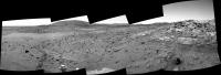
|
Posted by: jvandriel Feb 15 2006, 10:00 PM
Nirgal,
indeed, I still use Autostitch and Michael T's anti-vignetting tool.
Which of the panorama's do you prefere?
Post no. 263 or 267?
Regarding the parameters for antivig.
I always use the standard parameter "Protect bright pixels 7"
After antivig I use Paint Shop Pro 7 for equalizing the brightness and contrast of the images as much as
possible and in Autostitch I set the first Gain parameter to 0.2.
Ant103,
I use Autostitch for stitching the images. It is freeware and it's a great program.
www.autostitch.net
You can also read the autostitch thread in the tech forum.
jvandriel
Posted by: paulanderson Feb 15 2006, 10:30 PM
It looks very much as if HP is sitting in the remnant of a volcanic vent (the source of the apparent ash that makes up HP) that not only created HP, but also burped up the volcanic rock around it. Apparently, the vent was active for some time, never too violently, but long enough and frequently enough to pile up many very localized ash layers. Another item that argues somewhat for a vent, versus an impact crater, is that impact craters are more round than is HP.
The biggest question of all, though, has to be - why is there so much volcanic rock in this localized area around HP - and not hardly any less than a couple of hundred meters away?
Yes, good question. This would seem to back up my and others' contention that this may indeed be a volcanic vent that HP is sitting in and not simply an eroded impact crater. It may be, but I still question that, given, as you stated, all the volcanic debris lying right around HP. Coincidence? Just because something may superficially look like an impact crater doesn't necessarily mean it is (the same goes for the mini-craters in Meridiani). And there is that larger volcano just north of Gusev, also. Just an observation, that's all.
Posted by: jamescanvin Feb 15 2006, 11:13 PM
See http://www.physics.usyd.edu.au/~jcanvin/mer/index.html#A0748 to download full and half res versions.
James
A couple more frames added...

Posted by: djellison Feb 15 2006, 11:19 PM
Perfect timing
http://www.planetary.org/explore/topics/mars_exploration_rovers/audio.html
Mars Exploration Rover raw images »
Pancam team image website »
Home Plate views by James Canvin »
Doug
Posted by: Nirgal Feb 15 2006, 11:33 PM
indeed, I still use Autostitch and Michael T's anti-vignetting tool.
Which of the panorama's do you prefere?
Post no. 263 or 267?
jvandriel
Posted by: jamescanvin Feb 15 2006, 11:36 PM
http://www.planetary.org/explore/topics/mars_exploration_rovers/audio.html
Doug
Glad to be of service.
Posted by: Ant103 Feb 15 2006, 11:41 PM
"super-resolution images" ? Where do they come from? Is there more precisely images from the Pancam? I'm curious.
Posted by: Nirgal Feb 15 2006, 11:46 PM
thanks jvandriel.
the one with the extended "sky frame" is phantastic
coincidently, In the mean time I also discovered the additional "sky" frame and used it to do a full resolution stitch by myself (but thanks for your offering anyway !)
BTW.: I also use the combo autostitch+antivig+Paint Shop Pro ... (plus some weird self written command line tools
The main problem with autostitch is to straighten the horizon using the ominous phi,spi,theta parameters:
I have found that the best way to do it is set the resolution to 10% and then just do it by try & error
(simply try different parameter combos between 0 and 20 degrees for psi,phi and theta)
Here is the colorized final result (I somwhat over-saturized the color contrast to better match the
high brighntess contrast: in reality there would be much less contrast in brighness as well as in color...
but I prefer the more crisp look of the contrast stretched images too
http://mitglied.lycos.de/user73289/misc/spirit_n752_col_b.jpg
Posted by: Shaka Feb 15 2006, 11:51 PM
indeed, I still use Autostitch and Michael T's anti-vignetting tool.
Which of the panorama's do you prefere?
Post no. 263 or 267?
Regarding the parameters for antivig.
I always use the standard parameter "Protect bright pixels 7"
After antivig I use Paint Shop Pro 7 for equalizing the brightness and contrast of the images as much as
possible and in Autostitch I set the first Gain parameter to 0.2.
Ant103,
I use Autostitch for stitching the images. It is freeware and it's a great program.
www.autostitch.net
You can also read the autostitch thread in the tech forum.
jvandriel
I'm sure it's more difficult than you make it seem, J van, so I'm content to leave the job to you masters and just enjoy the results. And there's more to it than just enjoyment. Thanks to the tireless efforts of you guys to produce these panoramas, the 'true color' vistas, the 3D anaglyphs, I've recently noted a fundamental and precious shift in my mental appreciation of the 4th planet from the sun. The environs of the Columbia Hills in Gusev Crater have now become a place to me! I believe you could drop me down here somewhere (appropriately garbed, preferably) and I would know where I was! I would be able to set off for Comanche to do a little amateur geology of my own. I'd, yes...feel at home here! I could drive around here in a rover, more or less with the same serene comfort that I drive around Kaneohe, Hawaii. I wasn't getting this at JPL's site. They seemed to have lost the interest or resources to stitch up the panoramas or assemble the colors or the 3D. That's why I hunted for this forum. I owe you guys a lot, even if I don't always express my gratitude. I've seen some of planet Earth, but I also know some of Mars.
Damn!
Posted by: Astro0 Feb 16 2006, 03:55 AM
Thanks to the UMSF contributors for keeping us all going while there was a bit of an "image-fix withdrawal" forced on us by a couple of sick-servers.
Really loved Nirgal's colour version of jvandriel's stitch/vignette-fix panorama from Spirit of Homeplate/HH/El Dorado.
Couldn't resist adding my little touch of putting Spirit into the picture.
Enjoy!
Astro0
File size: 399k

|
NB: There is a larger version available at 1.6mb if anyone's interested.
Posted by: CosmicRocker Feb 16 2006, 05:50 AM
|
|
Interestingly, it seems to be lying in the center of a shallow circular pit. Possibly coincidence.
Here's a close-up:
|
|
The more I look at that close-up, the more interesting this thing becomes. Between the ball and the edge of the circular pit there are at least two distinct circular lineations. There must be a really nice geological term for this, but I don't know it.
|
|
Factoring in the rings surrounding the sphereoid, I think that there is no real doubt that this is in fact a cementation (concretion?), similar to the blueberries at Meridiani, but I suspect of a different composition. I've seen similar concretions in sandstone underlying limestone in central Texas. Further, to the best of my knowledge these things require water to form (at least dampness), so presumably this says something about the local geological history.
I'm beginning to wonder about concretions, too. I couldn't help but reach back for that observation of a very spherical object. After having looked at all of the MIs from this interesting piece of float, and after noting tdemko's comment that the sorting is better described as "moderate to well," I am seeing a wider distribution of grain diameters. I think Sunspot had also identified spherical clumping on some of the first MIs of this rock.
I am beginning to wonder about some of the "grains" I think I am seeing. Some of them are exceptionally spherical, although very small. I am attaching an MI with arrows pointing to two of the most remakable I've found. It is much smaller than the one algorimancer showed us, but it has similarities. Slightly above it, I see another that, based on the shadowing, appears to be broken in half and displaying a hollow center. I don't know what it is, but there may be more going on in the Home Plate game than I was thinking.
I was wondering if I could quote from more than one topic. I guess we can. I harvested Ed's observation from the Home Plate Speculations topic.
In the lower left corner of this image, I see what looks like the type of crossbedding that was so exciting in eagle crater.
Ed: I wanted to verify that you were talking about the set of laminae that I have pointed an arrow toward in the attached image. That was a very good catch. I think that is the most concave set of cross laminations we've seen at Home Plate. I missed it in my search. I'd be interested to hear comments from the cross-bedding experts regarding whether that could be eolian, or if it might suggest water.
Damn, this is a blast! (Sorry to some, about the huge footprint of this post. I sometimes do that when I'm excited.) We have quite an interesting collaboration of experts here.

|

|
Posted by: Tesheiner Feb 16 2006, 09:03 AM
I have found that the best way to do it is set the resolution to 10% and then just do it by try & error
(simply try different parameter combos between 0 and 20 degrees for psi,phi and theta)
Nirgal, I posted few tips on handling those parameters some time ago on the autostitch thread.
Here: http://www.unmannedspaceflight.com/index.php?s=&showtopic=1071&view=findpost&p=26418.
Actually, I'm no longer doing that try&error method but directly calculating the psi (rotation) from the source images. For panoramas with a good horizon reference the first try is usually the first and only one.
Posted by: Rakhir Feb 16 2006, 09:03 AM
Really loved Nirgal's colour version of jvandriel's stitch/vignette-fix panorama from Spirit of Homeplate/HH/El Dorado.
Couldn't resist adding my little touch of putting Spirit into the picture.
Enjoy!
Astro0
Very nice work Astro0 !
I really love these pictures with Spirit or Oppy in context.
-- Rakhir
Posted by: Tesheiner Feb 16 2006, 09:05 AM
Really loved Nirgal's colour version of jvandriel's stitch/vignette-fix panorama from Spirit of Homeplate/HH/El Dorado.
Couldn't resist adding my little touch of putting Spirit into the picture.
Enjoy!
Astro0
File size: 399k
|
|
NB: There is a larger version available at 1.6mb if anyone's interested.
Hey, what about that "virtual" BBQ on the forum meeting thread? This could be a nice background.
Posted by: Bill Harris Feb 16 2006, 09:13 AM
Good post. Tom and good finds in the Pancam and MI images. Don't worry about the length of the post, sometimes one has to wear big shoes to cover the subjact. Better than wearing "clown shoes", as needed elsewhere.
DejaVu: Upper Dells.
--Bill
Posted by: Tesheiner Feb 16 2006, 09:23 AM
Driving sol on both sides of Mars.
755 p1201.21 2 0 0 2 0 4 front_haz_penultimate_1_bpp_vhi_30
755 p1212.07 2 0 0 2 0 4 front_haz_ultimate_2_bpp_pri15
755 p1214.05 2 0 0 2 0 4 front_hazcam_ultimate_4_bpp
755 p1301.09 2 0 0 2 0 4 penultimate_rear_hazcam_pri_17
755 p1312.09 2 0 0 2 0 4 ultimate_rear_hazcam_2_bpp_pri15
755 p1950.08 2 0 0 2 0 4 navcam_mtes_hardball_1bpp_pri57
755 p2365.15 12 0 0 12 2 26 pancam_drive_dir_L7R1
755 p2600.07 2 2 0 0 2 6 pancam_tau
755 p2631.01 11 0 0 0 2 13 pancam_sky_spot_L234567R34567
Posted by: jvandriel Feb 16 2006, 10:58 AM
Here is the complete one.
Taken on Sol 748 with the R1 pancam.
jvandriel
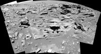
|
Posted by: sranderson Feb 16 2006, 11:52 AM
Whenever I see a "mesa" like this, with horizontal bedding undisturbed by uplift, the first thing I think is that this formation used to be all around here, but has been eroded completely away except at this one location. Usually this is because some particular capstone protected it (but is now all eroded away itself). To have such a thing happen on Mars however, would take a really long time.
Scott
Posted by: Tesheiner Feb 16 2006, 11:57 AM
Just hearing the last interview with J.Bell, he speaks about "Preliminary characterization" (at 18:30) and later on (23:00) on the possibility (wishes?) to return back to Home Plate after the winter on McCool Hill.
Did I get that right?
Posted by: djellison Feb 16 2006, 12:01 PM
Yup - iirc the plan is to leave HP fairly soon, a week or two, and head to the hills, and then possibly return, depending on what the data they get now suggests about HP.
Doug
Posted by: Phil Stooke Feb 16 2006, 01:26 PM
The quote from Cornell provided by Bill included this:
"The [MI] field of view is therefore 3131 mm at the working distance. "
Over 3 metres? No, this is 31 by 31 mm!
Phil
Posted by: Bill Harris Feb 16 2006, 02:09 PM
Ouch! Bad job of proofing my cut-and-paste, I've corrected that post. Thanks for catching this.
--Bill
Posted by: algorimancer Feb 16 2006, 02:18 PM
I was wondering if I could quote from more than one topic. I guess we can. I harvested Ed's observation from the Home Plate Speculations topic.
And I thought my post had been lost amongst all the drop-stone discussion
Yes, I've been noticing those small spherules in the MI's too... not sure what to think of them, but I've been leaning towards impact or volcanic melt just because I have no experience with concretions this small. , but you may be right. I notice at least one other apparently broken & hollow spherule in that MI you hilighted... my experience with hollow spherules is that they have been bubbles of volcanic glass. It will be interesting to hear what the various spectra have to tell us about this material ... surely we can expect a press conference in the next week or two.As to the larger spherule about which I'd posted, I've noticed that it is distinctly dark in the R7 images, which suggests a different composition than much of the other material.
http://qt.exploratorium.edu/mars/spirit/pancam/2006-02-15/2P192769603EFFAO55P2271R7M1.JPG
I really hope they get some more color pancams of it, plus an MI, before we head for the hills.
Posted by: Bob Shaw Feb 16 2006, 02:35 PM
Doug
Excellent news!
Spirit could spent six months on HP, never mind six weeks...
Bob Shaw
Posted by: Burmese Feb 16 2006, 03:34 PM
New info:
http://www.newscientistspace.com/article.ns?id=dn8730
"Wednesday was Spirit's 754th Martian day (sol) in operation - a sol is 24 hours and 40 minutes. The team estimates it will take about 40 sols for Spirit to trek from Home Plate to McCool Hill and they want to arrive by sol 800"
Posted by: ljk4-1 Feb 16 2006, 03:37 PM
MARSDAILY
- 'Home Plate' Continues To Mystify Mars Rover Team
http://www.spacedaily.com/reports/Home_Plate_Continues_To_Mystify_Mars_Rover_Team.html
Pasadena CA (SPX) Feb 14, 2006 - The Mars Rover team at NASA's Jet Propulsion
Laboratory continues to pore over close-up images sent back by Spirit from a
tabletop-like geologic feature called Home Plate in Gusev Crater.
Posted by: aldo12xu Feb 16 2006, 04:46 PM
Yes, indeed! And it's made even more real when Nirgal and Astro0 offer us one of their marvelous creations
Posted by: Sunspot Feb 16 2006, 05:11 PM
http://marsrovers.jpl.nasa.gov/gallery/all/2/m/754/2M193315571EFFAOA0P2956M2M1.HTML
The small grains show up well in this brushed MI picture.
Posted by: Tesheiner Feb 16 2006, 05:23 PM
http://www.newscientistspace.com/article.ns?id=dn8730
"Wednesday was Spirit's 754th Martian day (sol) in operation - a sol is 24 hours and 40 minutes. The team estimates it will take about 40 sols for Spirit to trek from Home Plate to McCool Hill and they want to arrive by sol 800"
40 sols? It looks a bit conservative to me.
Being that the timeframe, I'm guessing if they plan to do a quick pancam survey of the west and south sides of Home Plate before heading to McCool Hill...

|

|
Posted by: Phil Stooke Feb 16 2006, 05:41 PM
Nirgal, I showed your new colour pan in my space exploration class. The students were very impressed.
Phil
Posted by: CosmicRocker Feb 16 2006, 06:35 PM
Whoah! I know that's the same rock, but is that the same rock?!
Posted by: algorimancer Feb 16 2006, 07:04 PM
A bit more regarding the apparent concretion (discussed previously here: http://www.unmannedspaceflight.com/index.php?showtopic=2189&st=165). I ran the images through Focus Magic to sharpen them a bit, then assembled a false color image which really brings out the details, then zoomed-in and enlarged the spherule:
Full image in false color. False color brings out details of the layering nicely:

|
Zoomed about the "concretion":

|
Cross-eyed, zoomed-in, stereo pair:

|
And for those of you who can cope with Jpeg2000 formatted images, here are the first two in that format (smaller, much higher quality):
http://www.clarkandersen.com/Jpeg2000/Jpeg2000.htm
Posted by: Nirgal Feb 16 2006, 07:38 PM
Couldn't resist adding my little touch of putting Spirit into the picture.
Enjoy!
Astro0
Thanks for your perfectly integrated Rover image ! (accurately simulated shadows even)
Once more I'm imressed to what great collaborative work the combined expertise in this forum
is capable of
Phil
Thanks for the nice words Phil ... it is highly appreciated ..
especially from an legendary space expert like you
Powered by Invision Power Board (http://www.invisionboard.com)
© Invision Power Services (http://www.invisionpower.com)