LAMO, aka Low Altitude Mapping Orbit |

  |
LAMO, aka Low Altitude Mapping Orbit |
 Dec 14 2011, 06:17 AM Dec 14 2011, 06:17 AM
Post
#46
|
||
 Senior Member  Group: Members Posts: 2492 Joined: 15-January 05 From: center Italy Member No.: 150 |
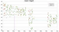
QUOTE (stevesliva @ Dec 14 2011, 02:43 AM)  First (?) image from near LAMO? Almost. Picture was taken before the two last main burns which reduced average height from 240 to 211 km, last week:
the purple arrow indicate the exact time/height when (I guess) the picture was snapped... -------------------- I always think before posting! - Marco -
|
|
 |
 
|
|
|
Dec 15 2011, 07:31 PM
Post
#47
|
|
|
Senior Member Group: Members Posts: 1592 Joined: 14-October 05 From: Vermont Member No.: 530 |
And now the image of the day is stalled again. Let's see some boulders!
|
|
|
|
|
Dec 15 2011, 07:56 PM
Post
#48
|
|
|
Senior Member Group: Members Posts: 2492 Joined: 15-January 05 From: center Italy Member No.: 150 |
QUOTE (stevesliva @ Dec 15 2011, 08:31 PM) Let's see some boulders! Steve, based on last Mission Status, The Dawn "image of the day" will take a break until Jan. 9. We have to wait next year! 
-------------------- I always think before posting! - Marco -
|
|
|
|
|
Dec 15 2011, 08:04 PM
Post
#49
|
|
|
Senior Member Group: Members Posts: 1592 Joined: 14-October 05 From: Vermont Member No.: 530 |
Doh. Thanks for pointing that out, it'll save some clicks on my part. That one photo is such a tease.
|
|
|
|
|
Dec 20 2011, 12:55 AM
Post
#50
|
|
|
Newbie Group: Members Posts: 5 Joined: 6-July 11 Member No.: 6050 |
Is it just me, or does that sharp, young crater in the top right of the image below have gullies in its walls that look remarkably similar to those in craters on Mars? The debate has been raging for some years now whether Martian crater gullies are formed by dry flow or by the flow of brine. I'm not suggesting for one moment that there's liquid flowing on the surface of Vesta, but the similarity of gullies here might suggest that most, if not all, Martian gullies formed via a dry mechanism.

|
|
|
|
|
Dec 20 2011, 06:54 PM
Post
#51
|
|
|
Member Group: Members Posts: 311 Joined: 31-August 05 From: Florida & Texas, USA Member No.: 482 |
QUOTE (Jaheira @ Dec 19 2011, 06:55 PM) Is it just me, or does that sharp, young crater in the top right of the image below have gullies in its walls that look remarkably similar to those in craters on Mars? The debate has been raging for some years now whether Martian crater gullies are formed by dry flow or by the flow of brine. I'm not suggesting for one moment that there's liquid flowing on the surface of Vesta, but the similarity of gullies here might suggest that most, if not all, Martian gullies formed via a dry mechanism. I noticed that same feature and assumed it was a landslide triggered by the same mechanism that created the apparent fault above the rim. As to what caused the fault, I'm not sure. I believe the "dry flow" mechanism for small scale flows of sediment on craters of Mars requires dry ice as the volatile that sublimates and then causes unweathered sediment to be exposed, making a dark band. I don't think the landslide on Vesta pictured here would be applicable to those discussions. |
|
|
|
|
Dec 21 2011, 06:05 PM
Post
#52
|
|
|
Senior Member Group: Members Posts: 1592 Joined: 14-October 05 From: Vermont Member No.: 530 |
Five LAMO images have appeared here:
http://dawn.jpl.nasa.gov/multimedia/vesta_dawn_gallery.asp |
|
|
|
|
Dec 28 2011, 04:25 AM
Post
#53
|
||
 Senior Member Group: Moderator Posts: 3242 Joined: 11-February 04 From: Tucson, AZ Member No.: 23 |
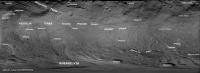
14 more names have been approved for use on Vesta, including the other two craters in the "snowman"
http://astrogeology.usgs.gov/HotTopics/ind...s-on-Vesta.html I've updated my labeled Vesta map to include these new names
-------------------- &@^^!% Jim! I'm a geologist, not a physicist!
The Gish Bar Times - A Blog all about Jupiter's Moon Io |
|
|
|
|
|
|
Jan 1 2012, 09:51 PM
Post
#54
|
|
|
Senior Member Group: Members Posts: 1018 Joined: 29-November 05 From: Seattle, WA, USA Member No.: 590 |
QUOTE (Greg Hullender @ Dec 2 2011, 10:06 AM) Supposedly that delay was running up against the window from Vesta to Ceres, so I suspect there may not be much more leeway to stay at Vesta. Perhaps someone who knows for sure will chime in. --Greg Sure enough, I got the following from Marc Rayman, which he invited me to share here: QUOTE We have quite a bit of technical flexibility to shift the Vesta departure. You're correct that we launched relatively late in the multiyear launch period for reaching both Vesta and Ceres, but that does not impose a significant constraint now. You may recall that our prelaunch model for the solar array power as a function of heliocentric range was demonstrated in flight to be conservative. Thanks to the ion propulsion system, we translated that power margin into the more operationally and scientifically useful resource of residence time at Vesta. But there has always been another constraint, and that is funding. Our mission timeline includes reaching Ceres in February 2015 not for reasons of celestial mechanics but because that is the schedule upon which the budget was formulated. The celestial mechanics is such that the time to travel from Vesta to Ceres is pretty insensitive to the departure date for up to ~ 0.5 years later than July 2012. But leaving later would mean an extension to the primary mission, and that is not budgeted. The simple reality, which I know you recognize, is that funding is extremely (perhaps even uniquely) tight these days. As soon as we determined the Vesta pole during the approach phase, we knew what it meant for seeing the north pole, but our plan to depart in July 2012 has not changed. Our agreement with NASA HQ (formalized in our level 1 requirements) has always been that we would image at least 80% of the surface of Vesta at 100 m/px in our panchromatic channel and at least three color filters. We have already done better than that, so it is not obvious that we have to see farther north, much as one might consider it to be neat to do so. In case this appears to be inconsistent with Emily's tweet about what Chris Russell said here at the AGU, let me be be explicit about it. It is correct that we would need to delay departure in order to see all the way to the north pole. That is not the same as saying we will delay departure. While plans may change, we remain scheduled for departure in July. We already have fabulous data on Vesta, and we certainly will have even more by then. It certainly would be nice to see the entire surface, but even if we don't, there's no doubt that what we will have seen at Vesta will be exceptionally valuable. Hope everyone has a happy (and interesting) New Year! --Greg |
|
|
|
|
Jan 2 2012, 08:20 AM
Post
#55
|
|
|
Member Group: Members Posts: 544 Joined: 17-November 05 From: Oklahoma Member No.: 557 |
Thanks Greg.
I'd be interested to know how far north the project scientists think that the antipode(s) of the one or two giant southern impacts are, and the chances of them being observed before the end. Or perhaps they've already been spotted? |
|
|
|
|
Jan 3 2012, 01:42 PM
Post
#56
|
|
 Member Group: Members Posts: 656 Joined: 20-April 05 From: League City, Texas Member No.: 285 |
Spacedaily has an article up today (http://www.spacedaily.com/reports/Space_Mountain_Produces_Terrestrial_Meteorites_999.html) that states with regard to Dawn's Vesta mission that "no one expected a 13-mile high mountain, two and a half times higher than Mount Everest". Considering the earlier Hubble results, they probably should have fact-checked that line -- or were they mislead by a press release?
|
|
|
|
|
Jan 5 2012, 03:42 PM
Post
#57
|
|
|
Senior Member Group: Members Posts: 1018 Joined: 29-November 05 From: Seattle, WA, USA Member No.: 590 |
New Dawn Journal: http://dawn.jpl.nasa.gov/mission/journal_12_30_11.asp
Nice info about the challenges of maintaining such a low orbit around such an irregular body. Also nice to learn that they haven't had to use even one day of their 40-day reserve. (The buffer in the science schedule to allow for things to go wrong.) If I'm interpreting that right, they essentially get a 40-day extended mission at Vesta for free, which is kind of cool. By the way, this is my 1,000th post at UMSF, which is also kind of cool. --Greg |
|
|
|
|
Jan 5 2012, 09:02 PM
Post
#58
|
|
|
Senior Member Group: Members Posts: 1592 Joined: 14-October 05 From: Vermont Member No.: 530 |
What a tease to link to the image of the day after discussing the wonderful LAMO images... because none of them are there yet.
|
|
|
|
|
Jan 5 2012, 09:51 PM
Post
#59
|
|
|
Solar System Cartographer Group: Members Posts: 10229 Joined: 5-April 05 From: Canada Member No.: 227 |
-------------------- ... because the Solar System ain't gonna map itself.
Also to be found posting similar content on https://mastodon.social/@PhilStooke Maps for download (free PDF: https://upload.wikimedia.org/wikipedia/comm...Cartography.pdf NOTE: everything created by me which I post on UMSF is considered to be in the public domain (NOT CC, public domain) |
|
|
|
|
Jan 5 2012, 10:01 PM
Post
#60
|
|
|
Senior Member Group: Members Posts: 1592 Joined: 14-October 05 From: Vermont Member No.: 530 |
I know there are some kicking around. Just hoping for the image of the day to start up again.
|
|
|
|
|

|
Lo-Fi Version | Time is now: 27th September 2024 - 05:39 AM |
|
RULES AND GUIDELINES Please read the Forum Rules and Guidelines before posting. IMAGE COPYRIGHT |
OPINIONS AND MODERATION Opinions expressed on UnmannedSpaceflight.com are those of the individual posters and do not necessarily reflect the opinions of UnmannedSpaceflight.com or The Planetary Society. The all-volunteer UnmannedSpaceflight.com moderation team is wholly independent of The Planetary Society. The Planetary Society has no influence over decisions made by the UnmannedSpaceflight.com moderators. |
SUPPORT THE FORUM Unmannedspaceflight.com is funded by the Planetary Society. Please consider supporting our work and many other projects by donating to the Society or becoming a member. |
|