Chandrayaan 3 lander and rover, India's lunar mission to replace Chandrayaan 2's lander/rover |

  |
Chandrayaan 3 lander and rover, India's lunar mission to replace Chandrayaan 2's lander/rover |
 Aug 31 2023, 07:19 PM Aug 31 2023, 07:19 PM
Post
#166
|
||
|
Solar System Cartographer  Group: Members Posts: 10153 Joined: 5-April 05 From: Canada Member No.: 227 |
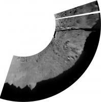
neo56 pointed out (post #137 above) that the horizons in the first two Pragyan images could be combined to make a mini-panorama. The foregrounds don't match so it only works with the horizon features.
Near the left end of that mini-pan there is a trio of craters. I noticed they are also seen on one of the recent images of the lander, so another image can be added to the panorama. There is a second lander image where the lander blocks a different bit of the horizon so it could be added as well, but the geometry is tricky so I haven't tried it yet. Phil
-------------------- ... because the Solar System ain't gonna map itself.
Also to be found posting similar content on https://mastodon.social/@PhilStooke Maps for download (free PD: https://upload.wikimedia.org/wikipedia/comm...Cartography.pdf NOTE: everything created by me which I post on UMSF is considered to be in the public domain (NOT CC, public domain) |
|
 |
 
|
|
|
Aug 31 2023, 07:40 PM
Post
#167
|
||
|
Solar System Cartographer Group: Members Posts: 10153 Joined: 5-April 05 From: Canada Member No.: 227 |
Experimenting further, I added parts of the second image and played with a reprojection to try to match with orbital images. I don't really know how much of the horizon is visible here so treat this as an experiment, not true geometry.
Phil
-------------------- ... because the Solar System ain't gonna map itself.
Also to be found posting similar content on https://mastodon.social/@PhilStooke Maps for download (free PD: https://upload.wikimedia.org/wikipedia/comm...Cartography.pdf NOTE: everything created by me which I post on UMSF is considered to be in the public domain (NOT CC, public domain) |
|
|
|
|
|
|
Aug 31 2023, 09:22 PM
Post
#168
|
|
 Senior Member Group: Members Posts: 1423 Joined: 26-July 08 Member No.: 4270 |
Chandrayaan-3 seismograph detecting rover motion... and maybe a moonquake?
https://www.isro.gov.in/Ch3_ILSA_Listens_Landing_Site.html -------------------- -- Hungry4info (Sirius_Alpha)
|
|
|
|
|
Aug 31 2023, 10:35 PM
Post
#169
|
||
 Member Group: Members Posts: 891 Joined: 15-June 09 From: Lisbon, Portugal Member No.: 4824 |
As of a few minutes ago LROC had not released an image of Chandrayaan's landing site. LROC's resolution is 0.5 m/pixel and Pragyan is under 1m in length/width. Its wheels are very narrow, so I think it will be quite difficult to identify any tracks. Pragyan's full traverse route has not been publicly shared, to my knowledge. But looking at the image of backtracking due to a large (4m) crater, a boulder on a further away crater's rim set me wondering. So here is a wild guess, a total speculation, just for the fun of it. Any comments are very welcome!
Fernando |
|
|
|
|
|
|
Sep 1 2023, 12:05 AM
Post
#170
|
|
|
Solar System Cartographer Group: Members Posts: 10153 Joined: 5-April 05 From: Canada Member No.: 227 |
Hi Nogal - I think the hills on the horizon in the image you show are on the south horizon, not the east.
Phil -------------------- ... because the Solar System ain't gonna map itself.
Also to be found posting similar content on https://mastodon.social/@PhilStooke Maps for download (free PD: https://upload.wikimedia.org/wikipedia/comm...Cartography.pdf NOTE: everything created by me which I post on UMSF is considered to be in the public domain (NOT CC, public domain) |
|
|
|
|
Sep 1 2023, 07:28 AM
Post
#171
|
|
|
Member Group: Members Posts: 103 Joined: 12-September 19 Member No.: 8664 |
Gallery updated with images from rover.
https://www.isro.gov.in/chandrayaan3_gallery.html |
|
|
|
|
Sep 2 2023, 12:28 PM
Post
#172
|
||
|
Senior Member Group: Members Posts: 1423 Joined: 26-July 08 Member No.: 4270 |
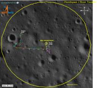
ISRO's twitter has provided us with a route map for Pragyan.
QUOTE Meanwhile, over the Moon, Pragan Rover has traversed over 100 meters and continuing.
Attached thumbnail(s)
-------------------- -- Hungry4info (Sirius_Alpha)
|
|
|
|
|
|
|
Sep 2 2023, 06:50 PM
Post
#173
|
|
|
Member Group: Members Posts: 891 Joined: 15-June 09 From: Lisbon, Portugal Member No.: 4824 |
QUOTE (Phil Stooke @ Sep 1 2023, 01:05 AM)  Hi Nogal - I think the hills on the horizon in the image you show are on the south horizon, not the east. Thanks for pointing it out Phil. Phil Fernando |
|
|
|
|
Sep 2 2023, 07:22 PM
Post
#174
|
|
|
Senior Member Group: Members Posts: 1423 Joined: 26-July 08 Member No.: 4270 |
From ISRO's twitter.
https://twitter.com/isro/status/1698010732128764164 QUOTE The Rover completed its assignments.
It is now safely parked and set into Sleep mode. APXS and LIBS payloads are turned off. Data from these payloads is transmitted to the Earth via the Lander. Currently, the battery is fully charged. The solar panel is oriented to receive the light at the next sunrise expected on September 22, 2023. The receiver is kept on. Hoping for a successful awakening for another set of assignments! Else, it will forever stay there as India's lunar ambassador. -------------------- -- Hungry4info (Sirius_Alpha)
|
|
|
|
|
Sep 2 2023, 09:39 PM
Post
#175
|
|
|
Member Group: Members Posts: 891 Joined: 15-June 09 From: Lisbon, Portugal Member No.: 4824 |
ISRO has Xed (twitted) again: Chandrayaan-3 Mission:Fernando |
|
|
|
|
Sep 2 2023, 11:15 PM
Post
#176
|
|
|
Solar System Cartographer Group: Members Posts: 10153 Joined: 5-April 05 From: Canada Member No.: 227 |
The route map from ISRO is great to have but I am a bit unsure about the scale. The scale bar says 50 m x 50 m, which I presume means the bar represents 50 m and the scale is the same in both N-S and E-W directions. You might say all maps should have the same scale in both directions but that's not true of, for instance, most parts of a simple cylindrical (equirectangular) map.
OK, so what about the statement that the total traverse is 101.4 m? The only way that seems to match the scale bar is if 101.4 m is the straight line distance from Vikram to Pragyan at the end of its travels. The actual distance driven could be nearly twice that. Presumably each individual drive is shown by a line of different colour. Lets hope we see some more Pragyan images soon. Phil -------------------- ... because the Solar System ain't gonna map itself.
Also to be found posting similar content on https://mastodon.social/@PhilStooke Maps for download (free PD: https://upload.wikimedia.org/wikipedia/comm...Cartography.pdf NOTE: everything created by me which I post on UMSF is considered to be in the public domain (NOT CC, public domain) |
|
|
|
|
Sep 2 2023, 11:55 PM
Post
#177
|
|
 Senior Member Group: Members Posts: 4246 Joined: 17-January 05 Member No.: 152 |
Would it work if the full dimensions of the map were 50x50m, and the "total traverse" was the total path length? Or perhaps the radius of the large yellow circle was 50m?
I get the visual impression that this path was drawn by hand, so perhaps it isn't very accurate. |
|
|
|
|
Sep 3 2023, 06:01 AM
Post
#178
|
|
|
Solar System Cartographer Group: Members Posts: 10153 Joined: 5-April 05 From: Canada Member No.: 227 |
Why didn't I think to do this before? I compared it with Jake's map, and of course Fred was right, the radius of the circle is 50 m. That makes the total distance driven look like 101.4 m. So the way the scale bar is labelled is misleading.
Phil -------------------- ... because the Solar System ain't gonna map itself.
Also to be found posting similar content on https://mastodon.social/@PhilStooke Maps for download (free PD: https://upload.wikimedia.org/wikipedia/comm...Cartography.pdf NOTE: everything created by me which I post on UMSF is considered to be in the public domain (NOT CC, public domain) |
|
|
|
|
Sep 3 2023, 05:32 PM
Post
#179
|
|
|
Member Group: Members Posts: 103 Joined: 12-September 19 Member No.: 8664 |
Have there been any LRO passes over the landing site in last 10 days?
|
|
|
|
|
Sep 3 2023, 11:40 PM
Post
#180
|
|
|
Solar System Cartographer Group: Members Posts: 10153 Joined: 5-April 05 From: Canada Member No.: 227 |
Yes, there was a flyover in sunlight about 2 days after landing. No release of details yet but there is no urgency since the OHRC image was already published. LRO will be a bit less detailed than OHRC but would show the rover on the surface.
Phil -------------------- ... because the Solar System ain't gonna map itself.
Also to be found posting similar content on https://mastodon.social/@PhilStooke Maps for download (free PD: https://upload.wikimedia.org/wikipedia/comm...Cartography.pdf NOTE: everything created by me which I post on UMSF is considered to be in the public domain (NOT CC, public domain) |
|
|
|
|

|
Lo-Fi Version | Time is now: 30th April 2024 - 08:55 PM |
|
RULES AND GUIDELINES Please read the Forum Rules and Guidelines before posting. IMAGE COPYRIGHT |
OPINIONS AND MODERATION Opinions expressed on UnmannedSpaceflight.com are those of the individual posters and do not necessarily reflect the opinions of UnmannedSpaceflight.com or The Planetary Society. The all-volunteer UnmannedSpaceflight.com moderation team is wholly independent of The Planetary Society. The Planetary Society has no influence over decisions made by the UnmannedSpaceflight.com moderators. |
SUPPORT THE FORUM Unmannedspaceflight.com is funded by the Planetary Society. Please consider supporting our work and many other projects by donating to the Society or becoming a member. |
|