InSight Surface Operations, 26 Nov 2018- 21 Dec 2022 |

InSight Surface Operations, 26 Nov 2018- 21 Dec 2022 |
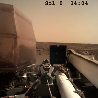
 Nov 26 2018, 08:20 PM Nov 26 2018, 08:20 PM
Post
#1
|
|
|
Merciless Robot  Group: Admin Posts: 8783 Joined: 8-December 05 From: Los Angeles Member No.: 602 |
Congratulations to the InSight team on a successful landing! We'll discuss the remainder of the mission here.

-------------------- A few will take this knowledge and use this power of a dream realized as a force for change, an impetus for further discovery to make less ancient dreams real.
|
 |
 
|
 |
|
Nov 27 2018, 03:26 AM
Post
#2
|
|
|
Member Group: Members Posts: 282 Joined: 18-June 04 Member No.: 84 |
At nearly 20 feet/6m, InSight should look quite interesting to HiRISE.
|
|
|
|
|
Nov 27 2018, 03:28 AM
Post
#3
|
|
|
Forum Contributor Group: Members Posts: 1372 Joined: 8-February 04 From: North East Florida, USA. Member No.: 11 |
Confirmation the solar panels have deployed.
Also the panels are slightly bigger and stronger than Phoenix's were. Insight Is Catching Rays on Mars. |
|
|
|
|
Nov 27 2018, 03:35 AM
Post
#4
|
|
|
Merciless Robot Group: Admin Posts: 8783 Joined: 8-December 05 From: Los Angeles Member No.: 602 |
It should. Phoenix was unmistakeable even as the dust began to settle on her.
-------------------- A few will take this knowledge and use this power of a dream realized as a force for change, an impetus for further discovery to make less ancient dreams real.
|
|
|
|
|
Nov 27 2018, 03:35 AM
Post
#5
|
|
|
Member Group: Members Posts: 507 Joined: 10-September 08 Member No.: 4338 |
https://mars.nasa.gov/insight-raw-images/su...0000_0106M_.PNG
Are we seeing reflections in the plates of the large structure on the left? It might be handy having some mirrored surfaces to look around corners. |
|
|
|
|
Nov 27 2018, 03:36 AM
Post
#6
|
||||
|
Member Group: Members Posts: 306 Joined: 4-October 14 Member No.: 7273 |
Took a stab at cleaning up the MarCO-B cubesat departure image of Mars
And with the fisheye effect removed:
I think I've managed to ID major landmarks, but am uncertain.
|
|||
|
|
|
|||
|
Nov 27 2018, 04:01 AM
Post
#7
|
|
 Director of Galilean Photography Group: Members Posts: 896 Joined: 15-July 04 From: Austin, TX Member No.: 93 |
Ok Phil, how long before you triangulate Insight based on that large rock in the distance?

-------------------- Space Enthusiast Richard Hendricks
-- "The engineers, as usual, made a tremendous fuss. Again as usual, they did the job in half the time they had dismissed as being absolutely impossible." --Rescue Party, Arthur C Clarke Mother Nature is the final inspector of all quality. |
|
|
|
|
Nov 27 2018, 04:03 AM
Post
#8
|
|
|
Forum Contributor Group: Members Posts: 1372 Joined: 8-February 04 From: North East Florida, USA. Member No.: 11 |
QUOTE (marsophile @ Nov 27 2018, 03:35 AM)  https://mars.nasa.gov/insight-raw-images/su...0000_0106M_.PNG Are we seeing reflections in the plates of the large structure on the left? It might be handy having some mirrored surfaces to look around corners. That's the seismometer... Seismometer. |
|
|
|
|
Nov 27 2018, 04:13 AM
Post
#9
|
|
|
Founder Group: Chairman Posts: 14432 Joined: 8-February 04 Member No.: 1 |
QUOTE (jccwrt @ Nov 26 2018, 07:36 PM) I think I've managed to ID major landmarks, but am uncertain. I got similar results. Good news is - this image was heavily JPG compressed to get on the ground quick. A raw uncompressed version should be down....hopefully....tomorrow. I think Mars should look a LOT better without JPGification. Hopefully
|
|
|
|
|
Nov 27 2018, 04:20 AM
Post
#10
|
|
|
Member Group: Members Posts: 306 Joined: 4-October 14 Member No.: 7273 |
QUOTE (djellison @ Nov 26 2018, 10:13 PM) I got similar results. Good news is - this image was heavily JPG compressed to get on the ground quick. A raw uncompressed version should be down....hopefully....tomorrow. I think Mars should look a LOT better without JPGification. Hopefully Awesome. Something I've been curious about - was this the only planned image during the flyby, or will there be others as well? |
|
|
|
|
Nov 27 2018, 04:21 AM
Post
#11
|
|
|
Merciless Robot Group: Admin Posts: 8783 Joined: 8-December 05 From: Los Angeles Member No.: 602 |
Great news!
I'm looking forward to the MRO images of the chute & backshell on the surface, and hopefully the heat shield as well. Always interesting to see how those ended up. -------------------- A few will take this knowledge and use this power of a dream realized as a force for change, an impetus for further discovery to make less ancient dreams real.
|
|
|
|
|
Nov 27 2018, 04:22 AM
Post
#12
|
|
|
Founder Group: Chairman Posts: 14432 Joined: 8-February 04 Member No.: 1 |
QUOTE (jccwrt @ Nov 26 2018, 08:20 PM) Awesome. Something I've been curious about - was this the only planned image during the flyby, or will there be others as well? Should be a few more - not many - but a couple on the way in and a couple on the way out. A few from MarCO A as well ( this is from B ) |
|
|
|
|
Nov 27 2018, 04:30 AM
Post
#13
|
|
|
Member Group: Members Posts: 306 Joined: 4-October 14 Member No.: 7273 |
Looking forward to seeing them!
|
|
|
|
|
Nov 27 2018, 05:52 AM
Post
#14
|
|
|
Junior Member Group: Members Posts: 71 Joined: 12-December 16 Member No.: 8089 |
So, simple question, how many images are planned to be taken by the ICC and IDC during Sols 0-2?
|
|
|
|
|
Nov 27 2018, 11:23 AM
Post
#15
|
|
 Member Group: Members Posts: 550 Joined: 1-May 06 From: Scotland (Ecosse, Escocia) Member No.: 759 |
Emily says in her "What to Expect" article at the Planetary Society ...
Mars Insight Landing Preview ... that the Cruise Stage wreckage will impact up-range (east) of the landing site. Given the thin atmosphere and high altitude of the area, might we expect some components to survive entry and make it down to the surface? |
|
|
|
|
Nov 27 2018, 02:49 PM
Post
#16
|
|
|
Member Group: Members Posts: 156 Joined: 22-May 09 From: Ireland Member No.: 4792 |
A live view of the engineers reactions (YouTube) - a team sometimes less-mentioned: success, hugs, high-5's, fist-bumps, love, of exploration.
John |
|
|
|
|
Nov 27 2018, 02:49 PM
Post
#17
|
|
|
Solar System Cartographer Group: Members Posts: 10162 Joined: 5-April 05 From: Canada Member No.: 227 |
The MSL cruise stage made it to ground in pieces, and the splats were seen by HiRISE.
https://www.uahirise.org/ESP_029245_1755 Phil -------------------- ... because the Solar System ain't gonna map itself.
Also to be found posting similar content on https://mastodon.social/@PhilStooke Maps for download (free PD: https://upload.wikimedia.org/wikipedia/comm...Cartography.pdf NOTE: everything created by me which I post on UMSF is considered to be in the public domain (NOT CC, public domain) |
|
|
|
|
Nov 27 2018, 03:15 PM
Post
#18
|
|
|
Member Group: Members Posts: 550 Joined: 1-May 06 From: Scotland (Ecosse, Escocia) Member No.: 759 |
Thanks Phil. So no tungsten blocks this time, but I'm guessing there will surely be a lighter splatter out there somewhere.
|
|
|
|
|
Nov 27 2018, 03:40 PM
Post
#19
|
|
 Member Group: Members Posts: 214 Joined: 30-December 05 Member No.: 628 |
In the early stages of the mission, can InSight's seismometer be used in concert with the hammer that is to drive the thermal mole into the ground, as a sort of sonar device to help locate buried rocks and maybe identify the best path to get the mole all the way to its desired 5 meter depth?
Sorry- this belongs in the surface operations thread, which is where I intended to put it. I guess I can't move it now without some assistance from admin... Moved. -Admin. |
|
|
|
|
Nov 27 2018, 04:16 PM
Post
#20
|
|
|
Solar System Cartographer Group: Members Posts: 10162 Joined: 5-April 05 From: Canada Member No.: 227 |
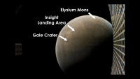
Right! So in this image:
https://static.uahirise.org/images/2012/det...BM-2H-scale.jpg the two largest splats are thought to be the tungsten blocks, but all the others are fragments of the cruise stage. Something similar should be visible to us this time. Every previous US lander except the Vikings had cruise stages which would have done this, but we didn't have a great camera to look for them before this (exception, Phoenix, but I never saw a search for cruise stage scars - maybe CTX from just after the Phoenix landing would reveal cruise stage impacts). Presumably the older mission cruise stage scars would be faded by now. Phil -------------------- ... because the Solar System ain't gonna map itself.
Also to be found posting similar content on https://mastodon.social/@PhilStooke Maps for download (free PD: https://upload.wikimedia.org/wikipedia/comm...Cartography.pdf NOTE: everything created by me which I post on UMSF is considered to be in the public domain (NOT CC, public domain) |
|
|
|
|
Nov 27 2018, 04:45 PM
Post
#21
|
|
|
Forum Contributor Group: Members Posts: 1372 Joined: 8-February 04 From: North East Florida, USA. Member No.: 11 |
QUOTE (tanjent @ Nov 27 2018, 04:40 PM) In the early stages of the mission, can InSight's seismometer be used in concert with the hammer that is to drive the thermal mole into the ground, as a sort of sonar device to help locate buried rocks and maybe identify the best path to get the mole all the way to its desired 5 meter depth? Moved. -Admin. There was no mention of that. The PI did say small rocks would be pushed aside by the Mole, but if it hit a big flat rock then that was as far as they could go, it won't go upwards. It's all about risk. |
|
|
|
|
Nov 27 2018, 05:12 PM
Post
#22
|
|
|
Member Group: Members Posts: 550 Joined: 1-May 06 From: Scotland (Ecosse, Escocia) Member No.: 759 |
My initial (and highly speculative) impression from the first images from each camera is that Insight has luckily landed inside one of those circular sandy areas that we first saw at the Spirit rover landing site in 2004. I think they were perhaps shallow craters in-filled with wind-blown dust and sand. The flat sandy terrain visible by the landing leg seems to finish abruptly a few tens of meters off, at rougher boulder terrain, from the higher viewpoint looking out alongside the seismometer cover.
But we will find out more fully in due course ! |
|
|
|
|
Nov 27 2018, 05:52 PM
Post
#23
|
|
 Senior Member Group: Members Posts: 1619 Joined: 12-February 06 From: Bergerac - FR Member No.: 678 |
First of all, a big applause for the team which have landed InSight on Mars. They've done it. Again. I am grateful to live such great moments
Second, I put my hand on the first IDC image downlinked, to remove some artifacts, review a little bit the colors.  And, I got my website updated, so it can receive further processing based on IDC (and maybe ICC). -------------------- |
|
|
|
|
Nov 27 2018, 06:12 PM
Post
#24
|
|
|
Forum Contributor Group: Members Posts: 1372 Joined: 8-February 04 From: North East Florida, USA. Member No.: 11 |
QUOTE (kenny @ Nov 27 2018, 06:12 PM) ... The flat sandy terrain visible by the landing leg seems to finish abruptly a few tens of meters off, at rougher boulder terrain, from the higher viewpoint looking out alongside the seismometer cover... To my eyes it looks like sandy spots interspersed with rocky spots. A billion years of wind and no rain can do strange things... And I still don't think it was the parking lot they expected. |
|
|
|
|
Nov 27 2018, 06:43 PM
Post
#25
|
|
|
Founder Group: Chairman Posts: 14432 Joined: 8-February 04 Member No.: 1 |
QUOTE (MahFL @ Nov 27 2018, 10:12 AM) And I still don't think it was the parking lot they expected. In the IDC image there is exactly one rock that could have caused a landing issue. There's nothing else out there that looks like it could have been an impairment to landing, or instrument deployment. This is exactly what was expected. From https://sharad.psi.edu/~ibsmith/pubs/Golombek_SSR_2016.pdf "Rock abundance in the smooth terrain averages ∼2.5 % (well below the 10 % requirement)" Seems we got what we ordered. |
|
|
|
|
Nov 27 2018, 07:07 PM
Post
#26
|
||
|
Solar System Cartographer Group: Members Posts: 10162 Joined: 5-April 05 From: Canada Member No.: 227 |
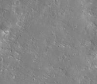
This is what HiRISE looks like in the approximate landing area (image number in file name if you save it). Lots of smooth patches between slightly rougher patches. Really not too many serious hazards. I'm looking! But we don't have much to go on yet.
Phil
-------------------- ... because the Solar System ain't gonna map itself.
Also to be found posting similar content on https://mastodon.social/@PhilStooke Maps for download (free PD: https://upload.wikimedia.org/wikipedia/comm...Cartography.pdf NOTE: everything created by me which I post on UMSF is considered to be in the public domain (NOT CC, public domain) |
|
|
|
|
|
|
Nov 27 2018, 09:51 PM
Post
#27
|
|
 Member Group: Members Posts: 611 Joined: 23-February 07 From: Occasionally in Columbia, MD Member No.: 1764 |
QUOTE (tanjent @ Nov 27 2018, 11:40 AM) In the early stages of the mission, can InSight's seismometer be used in concert with the hammer that is to drive the thermal mole into the ground, as a sort of sonar device to help locate buried rocks and maybe identify the best path to get the mole all the way to its desired 5 meter depth? Yes, and no. Yes, the seismometers will listen as the HP3 mole hammers itself into the ground, and will deduce near-surface seismic properties therefrom. Conceivably one could deduce the presence of reflectors such as buried rocks, although I don't know how unique such analyses would be. However, the mole is not steered. It just drives itself downwards. Ralph |
|
|
|
|
Nov 27 2018, 10:01 PM
Post
#28
|
|
|
Senior Member Group: Members Posts: 1044 Joined: 17-February 09 Member No.: 4605 |
Thanks for that link Doug. The tolerance of the lander to rocks in the landing site is impressive. Rocks up to 45 cm high underneath a footpad, rocks up to 45 cm high underneath the lander, and rocks up to 55 cm high underneath the deployed solar arrays. less 10 cm in all cases if excess energy has been absorbed by crushable material inside the lander legs.
|
|
|
|
|
Nov 28 2018, 12:10 AM
Post
#29
|
|
 Member Group: Members Posts: 290 Joined: 29-December 05 From: Ottawa, ON Member No.: 624 |
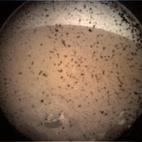
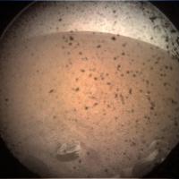
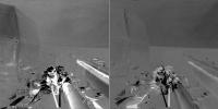
There are three new images for Sol 1, the same two angles from Sol 0, just a difference in shadows.
|
|
|
|
|
Nov 28 2018, 12:11 AM
Post
#30
|
|
|
Forum Contributor Group: Members Posts: 1372 Joined: 8-February 04 From: North East Florida, USA. Member No.: 11 |
|
|
|
|
|
Nov 28 2018, 12:11 AM
Post
#31
|
|
 Senior Member Group: Members Posts: 1431 Joined: 26-July 08 Member No.: 4270 |
New images are up.
Another from the workstation camera, the cover is still on as of Sol 1. https://mars.nasa.gov/insight-raw-images/su...0000_0589M_.PNG There's a couple new images from the robotic arm camera, one shows some movement of .. I think the grappling device at the end of the arm? https://mars.nasa.gov/insight-raw-images/su...0000_0463M_.PNG -------------------- -- Hungry4info (Sirius_Alpha)
|
|
|
|
|
Nov 28 2018, 12:38 AM
Post
#32
|
||
|
Member Group: Members Posts: 306 Joined: 4-October 14 Member No.: 7273 |
Some of the dust on the camera lens has moved around. Hard to say if this is from wind or because movement from the grapple gently shook some of it off.
|
|
|
|
|
|
|
Nov 28 2018, 12:44 AM
Post
#33
|
||
 Senior Member Group: Members Posts: 4247 Joined: 17-January 05 Member No.: 152 |
Doing a further max with the new ICC frame doesn't improve my sol 0 2-frame image much, since not much dust has moved and the lighting is different in the sol 1 image which causes artifacts especially near the centre of the frame, but here it is anyway:
|
|
|
|
|
|
|
Nov 28 2018, 12:46 AM
Post
#34
|
|
|
Solar System Cartographer Group: Members Posts: 10162 Joined: 5-April 05 From: Canada Member No.: 227 |
Not quite the same (I wrote this replying to fredk), look how the grapple moves between the two Sol 1 IDC images. And they are at different times of day so shadows move, including in the ICC images between sols 0 and 1.
Phil -------------------- ... because the Solar System ain't gonna map itself.
Also to be found posting similar content on https://mastodon.social/@PhilStooke Maps for download (free PD: https://upload.wikimedia.org/wikipedia/comm...Cartography.pdf NOTE: everything created by me which I post on UMSF is considered to be in the public domain (NOT CC, public domain) |
|
|
|
|
Nov 28 2018, 02:04 AM
Post
#35
|
||
|
Member Group: Members Posts: 808 Joined: 10-October 06 From: Maynard Mass USA Member No.: 1241 |
Here is a gif of Insight's deck from the IDC cam...
(the camera is on the 'forearm' section of the folded arm assembly)
-------------------- CLA CLL
|
|
|
|
|
|
|
Nov 28 2018, 02:23 AM
Post
#36
|
|
|
Merciless Robot Group: Admin Posts: 8783 Joined: 8-December 05 From: Los Angeles Member No.: 602 |
The new dance craze for all the cool kids this Northern Hemisphere winter will be the Grapple Snapp!
Thanks, PDP.A word on expectation management: The InSight team took great pains, I'd say, to emphasize that this mission will be considerably slower-paced than what we've become accustomed to over the years for Mars. Seems that I heard that surface instrument deployment probably won't begin till well after the holidays, though since it seems that they've begun testing arm mechanical functions we should see some of that at least in the near future. Also, they'll of course have to survey the putative instrument placement sites before making a commitment; that will doubtless take some time. All good. I guess geophysics missions require something a tiny bit closer to geological timescales to do right.
-------------------- A few will take this knowledge and use this power of a dream realized as a force for change, an impetus for further discovery to make less ancient dreams real.
|
|
|
|
|
Nov 28 2018, 02:32 AM
Post
#37
|
|
|
Senior Member Group: Members Posts: 2085 Joined: 13-February 10 From: Ontario Member No.: 5221 |
Yes, there's no wheels on this one. The nearest comparison is with Phoenix, and the team then was working with a much stricter deadline (Martian polar winter!) than InSight has. I'd be happy with a 360 panorama by Christmas!
|
|
|
|
|
Nov 28 2018, 02:57 AM
Post
#38
|
||
|
Solar System Cartographer Group: Members Posts: 10162 Joined: 5-April 05 From: Canada Member No.: 227 |
Just playing here, with the 3 IDC images making 2 pairs. These are difference images showing subtle changes - not so subtle on the deck where shadows and actual movement, but ignore that. The sky shows subtle changes between the two pairs, possibly related to clouds - very diffuse clouds - passing overhead. They have a radiometer to look for differences in illumination because it affects the heat flow, and those differences would include time of day, tau and cloud shadows.
Phil
-------------------- ... because the Solar System ain't gonna map itself.
Also to be found posting similar content on https://mastodon.social/@PhilStooke Maps for download (free PD: https://upload.wikimedia.org/wikipedia/comm...Cartography.pdf NOTE: everything created by me which I post on UMSF is considered to be in the public domain (NOT CC, public domain) |
|
|
|
|
|
|
Nov 28 2018, 03:24 AM
Post
#39
|
|
|
Member Group: Members Posts: 315 Joined: 1-October 06 Member No.: 1206 |
Thanks Phil. I hope we see some Philo-vision [TM] as soon as we get a significant stretch of the horizon in view!
I'm actually really looking forward to the meteorology package and magnetometer data. Any idea when and where we might see that appear? Another Phil |
|
|
|
|
Nov 28 2018, 04:47 AM
Post
#40
|
|
|
Junior Member Group: Members Posts: 48 Joined: 8-August 12 Member No.: 6507 |
QUOTE (antipode @ Nov 27 2018, 08:24 PM) Any idea when and where we might see that appear? Without providing information that is not to be made public, from the timeline I have seen for the near term, it looks like images with different viewpoints and other hoped for things will occur this week. Sort of like the first ten plays of a football game, the sol days 0-5 are pre-scripted and will occur roughly on the planned timeline (unless of course issues arise). Sol 1 had a planned grapple lock down release (as you see in the photos). Array power is above predicts (as things usually are since the predicts are a worst case analysis) which is a great result. |
|
|
|
|
Nov 28 2018, 03:09 PM
Post
#41
|
|
|
Senior Member Group: Members Posts: 4247 Joined: 17-January 05 Member No.: 152 |
QUOTE (Phil Stooke @ Nov 28 2018, 03:57 AM) These are difference images showing subtle changes - not so subtle on the deck where shadows and actual movement, but ignore that. The sky shows subtle changes between the two pairs, possibly related to clouds - very diffuse clouds - passing overhead. Some of the differences may be due to the onboard jpeg compression. Since the insight "raw" site is providing png's, that hopefully means that they are lossless relative to the received images - it wouldn't make sense to re-jpeg the received images and then convert those to pngs. I haven't heard anything about the original true raw images (ie, before onboard jpeg compression) eventually being sent home. |
|
|
|
|
Nov 28 2018, 04:44 PM
Post
#42
|
||
|
Member Group: Members Posts: 279 Joined: 19-August 07 Member No.: 3299 |
QUOTE (Phil Stooke @ Nov 27 2018, 01:07 PM) This is what HiRISE looks like in the approximate landing area (image number in file name if you save it). Lots of smooth patches between slightly rougher patches. Really not too many serious hazards. I'm looking! But we don't have much to go on yet. Phil
This land does not look to be a windy place since it has no lines of a bump of sand. |
|
|
|
|
|
|
Nov 28 2018, 04:50 PM
Post
#43
|
|
|
Solar System Cartographer Group: Members Posts: 10162 Joined: 5-April 05 From: Canada Member No.: 227 |
We haven't seen much of it yet! Lots more to see when the arm is raised.
Phil -------------------- ... because the Solar System ain't gonna map itself.
Also to be found posting similar content on https://mastodon.social/@PhilStooke Maps for download (free PD: https://upload.wikimedia.org/wikipedia/comm...Cartography.pdf NOTE: everything created by me which I post on UMSF is considered to be in the public domain (NOT CC, public domain) |
|
|
|
|
Nov 28 2018, 06:15 PM
Post
#44
|
||||
|
Solar System Cartographer Group: Members Posts: 10162 Joined: 5-April 05 From: Canada Member No.: 227 |
One result from the seismometer is expected to be the detection of impacts on Mars. And look at this, one occurred about 5 or 6 km from the landing site only 3 years ago.
Phil Before impact:
After impact:
close-up:
-------------------- ... because the Solar System ain't gonna map itself.
Also to be found posting similar content on https://mastodon.social/@PhilStooke Maps for download (free PD: https://upload.wikimedia.org/wikipedia/comm...Cartography.pdf NOTE: everything created by me which I post on UMSF is considered to be in the public domain (NOT CC, public domain) |
|||
|
|
|
|||
|
Nov 28 2018, 06:59 PM
Post
#45
|
|
|
Director of Galilean Photography Group: Members Posts: 896 Joined: 15-July 04 From: Austin, TX Member No.: 93 |
Looks like it broke up in the air before impacting. Probably not great for probing the core right?
-------------------- Space Enthusiast Richard Hendricks
-- "The engineers, as usual, made a tremendous fuss. Again as usual, they did the job in half the time they had dismissed as being absolutely impossible." --Rescue Party, Arthur C Clarke Mother Nature is the final inspector of all quality. |
|
|
|
|
Nov 28 2018, 07:03 PM
Post
#46
|
|
|
Solar System Cartographer Group: Members Posts: 10162 Joined: 5-April 05 From: Canada Member No.: 227 |
Being that close is not good for probing the core. For the core we need a big impact more than 60% of the way around the planet so waves pass through or around the core on the way to the seismometer.
Phil -------------------- ... because the Solar System ain't gonna map itself.
Also to be found posting similar content on https://mastodon.social/@PhilStooke Maps for download (free PD: https://upload.wikimedia.org/wikipedia/comm...Cartography.pdf NOTE: everything created by me which I post on UMSF is considered to be in the public domain (NOT CC, public domain) |
|
|
|
|
Nov 28 2018, 07:26 PM
Post
#47
|
|
 Senior Member Group: Members Posts: 1729 Joined: 3-August 06 From: 43° 35' 53" N 1° 26' 35" E Member No.: 1004 |
I had completely forgotten that I took a few pictures of an InSight mockup and French seismometer at the Le Bourget Airshow in 2015
https://www.flickr.com/photos/9228922@N03/1...57654838335682/ https://www.flickr.com/photos/9228922@N03/1...57654838335682/ https://www.flickr.com/photos/9228922@N03/1...57654838335682/ |
|
|
|
|
Nov 28 2018, 07:38 PM
Post
#48
|
|
 Member Group: Members Posts: 444 Joined: 1-July 05 From: New York City Member No.: 424 |
An article by Paul Voosen on the Science site, based on an interview with Matt Golombek, contains interesting details of JPLs initial assessment of Insights landing area.
https://www.sciencemag.org/news/2018/11/mar...g-study-planets |
|
|
|
|
Nov 28 2018, 08:01 PM
Post
#49
|
|
|
Senior Member Group: Members Posts: 2085 Joined: 13-February 10 From: Ontario Member No.: 5221 |
Good news from To's link regarding the sandy interior of a hollow!
Wondering about this bit though: QUOTE The biggest mystery for the lander team right now is figuring out exactly where it is. A Mars orbiter set to image the center of the landing zone on Thursday will miss the lander, because it missed the center slightly. An instrument on InSight called the inertial measurement unit has pinned the location to within a 5-kilometer-wide circle. InSight’s entry, descent, and landing team will refine that estimate down to a kilometer or less. They can't slew HiRise a little to the side where the IMU says the lander is? (my avatar's existence tells me MRO can do it) Or is the imaging strip just too thin to guarantee catching it on Thursday? |
|
|
|
|
Nov 28 2018, 08:25 PM
Post
#50
|
|
 Administrator Group: Admin Posts: 5172 Joined: 4-August 05 From: Pasadena, CA, USA, Earth Member No.: 454 |
MRO receives command sequences only a few times a month; its command load for the Thursday image is already onboard and can't be changed now.
-------------------- My website - My Patreon - @elakdawalla on Twitter - Please support unmannedspaceflight.com by donating here.
|
|
|
|
|
Nov 28 2018, 08:30 PM
Post
#51
|
|
|
Member Group: Members Posts: 550 Joined: 1-May 06 From: Scotland (Ecosse, Escocia) Member No.: 759 |
Thanks for the link, Tom Tamlyn, which includes this assessment :
its location, which closely resembles martian terrains previously scouted by the Spirit rover. For example, InSight landed in whats called a hollow, a crater that has been filled in with soil and leveled flat. QUOTE (kenny @ Nov 27 2018, 05:12 PM) My initial (and highly speculative) impression from the first images from each camera is that Insight has luckily landed inside one of those circular sandy areas that we first saw at the Spirit rover landing site in 2004. I think they were perhaps shallow craters in-filled with wind-blown dust and sand. The flat sandy terrain visible by the landing leg seems to finish abruptly a few tens of meters off, at rougher boulder terrain, from the higher viewpoint looking out alongside the seismometer cover. So wasn't too far adrift. Just sayin' ...!
|
|
|
|
|
Nov 29 2018, 12:15 AM
Post
#52
|
|
|
Member Group: Members Posts: 866 Joined: 15-March 05 From: Santa Cruz, CA Member No.: 196 |
Phoenix had a MARDI, though i recall it was never switched on due to some integration bug uncovered at the 11th hour that could have jeopardized the landing process. [EDIT: found the scoop on that]
I never thought about it until now, but I guess the Insight team decided to not to even include a MARDI for that or perhaps other reasons as well, so no descent images to help define the landing context. |
|
|
|
|
Nov 29 2018, 03:17 AM
Post
#53
|
|
|
Senior Member Group: Members Posts: 2517 Joined: 13-September 05 Member No.: 497 |
QUOTE (atomoid @ Nov 28 2018, 04:15 PM) I guess the Insight team decided to not to even include a MARDI for that or perhaps other reasons as well, so no descent images to help define the landing context. We offered a number of options, but they chose not to use any of them (of course they had a cost.) In all honesty the landing context argument isn't extremely compelling, assuming we get HiRISE images post-landing. -------------------- Disclaimer: This post is based on public information only. Any opinions are my own.
|
|
|
|
|
Nov 29 2018, 04:11 AM
Post
#54
|
|
|
Senior Member Group: Members Posts: 2517 Joined: 13-September 05 Member No.: 497 |
QUOTE A Mars orbiter set to image the center of the landing zone on Thursday will miss the lander, because it missed the center slightly. Missed with HiRISE. If only there was a wider-field "context camera"...  -------------------- Disclaimer: This post is based on public information only. Any opinions are my own.
|
|
|
|
|
Nov 29 2018, 05:17 AM
Post
#55
|
|
|
Junior Member Group: Members Posts: 59 Joined: 4-July 08 Member No.: 4251 |
From the following three tweets:
https://twitter.com/HiRISE/status/1067874528187973632 https://twitter.com/HiRISE/status/1067874791648940032 https://twitter.com/HiRISE/status/1067875300178980865 QUOTE MROs attempt to image InSight on the parachute during its descent was unsuccessful. The geometry was more challenging than the Phoenix & Curiosity images, and the uncertainty in timing and the limitations on MROs ability to rapidly pan the camera across the scene motivated the HiRISE team to use a camera setting which unfortunately saturated the detector. While disappointing, it is great to know that the parachute worked and the landing went as planned. We want to thank all the folks who worked hard on this (special thanks to @MarsMaven ) and we can't wait for some great science from InSight to start coming in!
|
|
|
|
|
Nov 29 2018, 05:53 AM
Post
#56
|
|
|
Merciless Robot Group: Admin Posts: 8783 Joined: 8-December 05 From: Los Angeles Member No.: 602 |
Kudos to the MRO team for the great try. I doubt that many of us can appreciate the level of effort required to even attempt this sort of feat.
Onward! -------------------- A few will take this knowledge and use this power of a dream realized as a force for change, an impetus for further discovery to make less ancient dreams real.
|
|
|
|
|
Nov 29 2018, 07:04 AM
Post
#57
|
|
|
Merciless Robot Group: Admin Posts: 8783 Joined: 8-December 05 From: Los Angeles Member No.: 602 |
From Science:
"Now, a friendly competition is on. Golombek and his peers hope to beat the satellites to fixing InSights location. They should have until 6 December, when an orbiter will likely capture it. Right now, theyre stretching out the scant imagery, trying to compare their hollow to existing high-resolution maps. Their job will get much easier next week, when the camera on the robotic arms elbow will be extended to photograph the landers terrain in detail." -------------------- A few will take this knowledge and use this power of a dream realized as a force for change, an impetus for further discovery to make less ancient dreams real.
|
|
|
|
|
Nov 29 2018, 10:04 AM
Post
#58
|
|
|
Senior Member Group: Members Posts: 1619 Joined: 12-February 06 From: Bergerac - FR Member No.: 678 |
What happened to the "raw" images page ?
https://mars.nasa.gov/insight/multimedia/raw-images/ There is none. -------------------- |
|
|
|
|
Nov 29 2018, 10:10 AM
Post
#59
|
|
|
Senior Member Group: Members Posts: 1044 Joined: 17-February 09 Member No.: 4605 |
Er....yes there are.....???
|
|
|
|
|
Nov 29 2018, 10:13 AM
Post
#60
|
|
|
Member Group: Admin Posts: 976 Joined: 29-September 06 From: Pasadena, CA - USA Member No.: 1200 |
QUOTE (nprev @ Nov 28 2018, 11:04 PM) From Science: "Now, a friendly competition is on. Golombek and his peers hope to beat the satellites to fixing InSights location...." I was thinking that Tim Parker in a couple of days after landing had Curiosity location to within 50cm using FHAZ, then realized InSight is in a parking lot without many features on the horizon. But if he managed to keep track of Opportunity while driving to Endeavour I'm pretty sure he will be able to do it in his sleep. ;-) Paolo -------------------- Disclaimer: all opinions, ideas and information included here are my own,and should not be intended to represent opinion or policy of my employer.
|
|
|
|
|
Nov 29 2018, 10:25 AM
Post
#61
|
|
|
Senior Member Group: Members Posts: 1619 Joined: 12-February 06 From: Bergerac - FR Member No.: 678 |
This is odd. I updated the page after cache erase, and now I have the pictures
-------------------- |
|
|
|
|
Nov 29 2018, 01:04 PM
Post
#62
|
|
|
Merciless Robot Group: Admin Posts: 8783 Joined: 8-December 05 From: Los Angeles Member No.: 602 |
The location 'race' is interesting, but the money quote there to me was that the elbow cam will begin surveying the surroundings next week.
-------------------- A few will take this knowledge and use this power of a dream realized as a force for change, an impetus for further discovery to make less ancient dreams real.
|
|
|
|
|
Nov 29 2018, 04:14 PM
Post
#63
|
|
|
Junior Member Group: Members Posts: 59 Joined: 4-July 08 Member No.: 4251 |
We didn't see any new images appear on the "raw images" site during Sol 2. I'm guessing they must have taken some and downlinked them. Therefore, it appears that we do not have the near-real-time pipeline of images to the public like we've seen on some previous missions, right?
EDIT: I don't want to clutter the forum with a new post, and this forum doesn't support "likes", so ... thank you Doug for your insightful reply! (immediately below) |
|
|
|
|
Nov 29 2018, 04:33 PM
Post
#64
|
|
|
Founder Group: Chairman Posts: 14432 Joined: 8-February 04 Member No.: 1 |
QUOTE (ChrisC @ Nov 29 2018, 08:14 AM) right? There are huge number of reasons that would cause there to be no images for a given sol. Spacecraft issues, DSN or Relay issues, to just straight up not commanding the acquisition of any images on a given sol. The InSight raw image page is probably the best version of a raw image pipeline I've ever seen. There is no reason to suggest the pipeline is down right now. |
|
|
|
|
Nov 29 2018, 05:07 PM
Post
#65
|
|
 Senior Member Group: Moderator Posts: 3233 Joined: 11-February 04 From: Tucson, AZ Member No.: 23 |
We were warned that this would be a slower paced mission than we're used to.
-------------------- &@^^!% Jim! I'm a geologist, not a physicist!
The Gish Bar Times - A Blog all about Jupiter's Moon Io |
|
|
|
|
Nov 29 2018, 05:07 PM
Post
#66
|
|
 Senior Member Group: Members Posts: 2530 Joined: 20-April 05 Member No.: 321 |
I hope this is at least 51% relevant for this thread
I noticed last night that the ExoMars rover's landing platform will also have a seismometer onboard. With a landing date of April 2021, this creates a piquant proximity to Insight's end of main mission. It would surely be a value-add to have two working seismometers on Mars at the same time, so that the location of any large quakes could be pinpointed. It looks like they may overlap either for a short time, if Insight functions for just two years, or perhaps much longer if Insight has the kind of extended lifespan that other martian missions have had.
|
|
|
|
|
Nov 29 2018, 05:10 PM
Post
#67
|
|
 Senior Member Group: Members Posts: 2173 Joined: 28-December 04 From: Florida, USA Member No.: 132 |
QUOTE (Ant103 @ Nov 29 2018, 06:04 AM) What happened to the "raw" images page ? I see images using your link, but just the six. Three of each view. I wonder when new images will be coming. |
|
|
|
|
Nov 29 2018, 05:40 PM
Post
#68
|
|
|
Member Group: Members Posts: 290 Joined: 29-December 05 From: Ottawa, ON Member No.: 624 |
This mission will definitely deviate from what we are used to. First, I'm still scratching my head at the torturously slow (three month) deployment of the two surface experiments. Most notably, this is not a picture taking mission. Furthermore, if it hadn't been for the delay over the seismometer, we'd be looking at black and white pictures only. The InSight project upgraded their cameras from single-channel greyscale to RGB colour by replacing the detectors with a Bayer-pattern version of the same resolution as the original detectors. This mission is not designed to take pretty pictures. It's designed to explore the interior of Mars. That will take some adjustments from the rovers where we get a new panorama every few sols.
|
|
|
|
|
Nov 29 2018, 05:58 PM
Post
#69
|
|
|
Senior Member Group: Members Posts: 2085 Joined: 13-February 10 From: Ontario Member No.: 5221 |
They have to be much more careful with the robotic arm than Phoenix was. The latter could (and did) lose soil out of the scoop due to wind, or just dumped it on the deck of the lander because of how clumpy it was. InSight needs to do the reverse, and carefully take the seismometer, its cover, and heat flow probe into their appropriate spots. As I mentioned above, there is no spacecraft-killing winter at this latitude, so they really have no need to rush.
|
|
|
|
|
Nov 29 2018, 06:03 PM
Post
#70
|
|
|
Member Group: Members Posts: 206 Joined: 15-August 07 From: Shrewsbury, Shropshire Member No.: 3233 |
QUOTE (Steve G @ Nov 29 2018, 06:40 PM) This mission will definitely deviate from what we are used to. First, I'm still scratching my head at the torturously slow (three month) deployment of the two surface experiments. Most notably, this is not a picture taking mission. Furthermore, if it hadn't been for the delay over the seismometer, we'd be looking at black and white pictures only. The InSight project upgraded their cameras from single-channel greyscale to RGB colour by replacing the detectors with a Bayer-pattern version of the same resolution as the original detectors. This mission is not designed to take pretty pictures. It's designed to explore the interior of Mars. That will take some adjustments from the rovers where we get a new panorama every few sols. Presumably there will be curiosity style selfies taken by the camera on the instrument arm to check that the instruments did not move on the deck during the landing and to provide 3D maps of the instrument deployment area. |
|
|
|
|
Nov 29 2018, 06:30 PM
Post
#71
|
|
|
Solar System Cartographer Group: Members Posts: 10162 Joined: 5-April 05 From: Canada Member No.: 227 |
Keep in mind that on a day when we don't get a new image, other things are going on. I don't know what those things might be on any given day, but over the next week or so the arm and the instruments are probably being powered on and checked very carefully to ensure everything is in good shape. Nobody likes images more than I do, and we will see them soon.
Phil -------------------- ... because the Solar System ain't gonna map itself.
Also to be found posting similar content on https://mastodon.social/@PhilStooke Maps for download (free PD: https://upload.wikimedia.org/wikipedia/comm...Cartography.pdf NOTE: everything created by me which I post on UMSF is considered to be in the public domain (NOT CC, public domain) |
|
|
|
|
Nov 29 2018, 06:35 PM
Post
#72
|
|
|
Forum Contributor Group: Members Posts: 1372 Joined: 8-February 04 From: North East Florida, USA. Member No.: 11 |
QUOTE (Steve G @ Nov 29 2018, 06:40 PM) ... First, I'm still scratching my head at the torturously slow (three month) deployment of the two surface experiments... Well in reality they are going to be deploying the instruments 2 or 3 times in the sandbox here on Earth, before they do it with Insight on Mars, so that takes time. |
|
|
|
|
Nov 29 2018, 07:05 PM
Post
#73
|
|
|
Junior Member Group: Members Posts: 57 Joined: 20-January 12 From: Florida Member No.: 6317 |
Between the two pictures, a small rectangular piece of equipment has rotated to the right just in front of the large square black thing, which reveals more of two mysterious white objects that look to be on the ground. I do not see any other white patches in the distance.
|
|
|
|
|
Nov 29 2018, 07:56 PM
Post
#74
|
|
 Member Group: Members Posts: 691 Joined: 21-December 07 From: Clatskanie, Oregon Member No.: 3988 |
What is so mysterious about it? That "white patch" is a piece of lander deck hardware.
|
|
|
|
|
Nov 29 2018, 08:52 PM
Post
#75
|
|
|
Administrator Group: Admin Posts: 5172 Joined: 4-August 05 From: Pasadena, CA, USA, Earth Member No.: 454 |
Another thing that is different about InSight is that from the beginning, they are not operating on Mars Time. They're working early and late slide sols as needed, but to keep operational costs lower they did not staff up to the level that would be required for Mars Time operations. So they'll spend some chunk of their time effectively in restricted sols.
-------------------- My website - My Patreon - @elakdawalla on Twitter - Please support unmannedspaceflight.com by donating here.
|
|
|
|
|
Nov 29 2018, 10:08 PM
Post
#76
|
|
|
Senior Member Group: Members Posts: 2085 Joined: 13-February 10 From: Ontario Member No.: 5221 |
I found a very detailed summary of deployment procedure/timeline here: https://www.nasaspaceflight.com/2018/11/ins...cience-mission/
|
|
|
|
|
Nov 30 2018, 12:00 AM
Post
#77
|
|
|
Member Group: Members Posts: 234 Joined: 8-May 05 Member No.: 381 |
Just a quick thought about the Insight payload. If the spacecraft did indeed land on a sand sheet or filled crater, it might be a problem for the seismometer. Any thickness of sand would, if I understand seismometers correctly, cause seismic signals to be dissipated before they reach the instrument. Sand, being much less compacted than rock, would not conduct a seismic signal nearly as well. Even soil should conduct better. I would love to be proven wrong. Alternate opinions welcomed.
|
|
|
|
|
Nov 30 2018, 12:46 AM
Post
#78
|
|
|
Forum Contributor Group: Members Posts: 1372 Joined: 8-February 04 From: North East Florida, USA. Member No.: 11 |
QUOTE (monitorlizard @ Nov 30 2018, 12:00 AM) Just a quick thought about the Insight payload. If the spacecraft did indeed land on a sand sheet or filled crater, it might be a problem for the seismometer. Any thickness of sand would, if I understand seismometers correctly, cause seismic signals to be dissipated before they reach the instrument. Sand, being much less compacted than rock, would not conduct a seismic signal nearly as well. Even soil should conduct better. I would love to be proven wrong. Alternate opinions welcomed. It's super sensitive, it can detect half the movement made by the vibration of a hydrogen atom. If something bangs into Mars, it'll detect it. |
|
|
|
|
Nov 30 2018, 12:47 AM
Post
#79
|
|
 Senior Member Group: Members Posts: 2428 Joined: 30-January 13 From: Penang, Malaysia. Member No.: 6853 |
Does anyone know if they have an official mission clock for InSight? Similar to the one we have for Curiosity link that shows the sol and current solar time.
|
|
|
|
|
Nov 30 2018, 12:50 AM
Post
#80
|
|
|
Merciless Robot Group: Admin Posts: 8783 Joined: 8-December 05 From: Los Angeles Member No.: 602 |
Per the Science article I posted earlier, the team does not seem to be concerned about that; quite the opposite, in fact. I'd guess that level, stable placement is much more critical, and that they are able to compensate for any attenuation that might be induced by a few meters of sand (if there's that much.)
Also provides good digging for the mole, which could help refine their understanding of the sand's properties to further refine their seismic compensation model. -------------------- A few will take this knowledge and use this power of a dream realized as a force for change, an impetus for further discovery to make less ancient dreams real.
|
|
|
|
|
Nov 30 2018, 12:57 AM
Post
#81
|
|
|
Forum Contributor Group: Members Posts: 1372 Joined: 8-February 04 From: North East Florida, USA. Member No.: 11 |
QUOTE (PaulH51 @ Nov 30 2018, 12:47 AM) Does anyone know if they have an official mission clock for InSight? Similar to the one we have for Curiosity link that shows the sol and current solar time. https://mars.nasa.gov/insight/ |
|
|
|
|
Nov 30 2018, 01:36 AM
Post
#82
|
|
 Member Group: Members Posts: 684 Joined: 24-July 15 Member No.: 7619 |
QUOTE (nprev @ Nov 30 2018, 12:50 AM) Per the Science article I posted earlier, the team does not seem to be concerned about that; quite the opposite, in fact. I'd guess that level, stable placement is much more critical, and that they are able to compensate for any attenuation that might be induced by a few meters of sand (if there's that much.) Also provides good digging for the mole, which could help refine their understanding of the sand's properties to further refine their seismic compensation model. Agreed on the mole, guesstimate is about 3 meters of sand, probe has around 5 meters of tether, so they're good for getting to bedrock. https://mars.nasa.gov/insight/spacecraft/instruments/seis/ QUOTE Just a quick thought about the Insight payload. If the spacecraft did indeed land on a sand sheet or filled crater, it might be a problem for the seismometer. Any thickness of sand would, if I understand seismometers correctly, cause seismic signals to be dissipated before they reach the instrument. Sand, being much less compacted than rock, would not conduct a seismic signal nearly as well. Even soil should conduct better. I would love to be proven wrong. Alternate opinions welcomed. If the sand were recent uncompacted dunes like you get on Earth seashore, that might be a problem. Most dunes on Mars are suspected to be ancient, so the sand is likely filled in with fine dust. The landing area is on the slope between the highlands and the lowlands, Check out Figure #9 about possible sediment transport at the Highlands/Lowlands border http://oro.open.ac.uk/56400/1/The%20Hypani...rly%20Mars_.pdf if the lowlands were oceans, then mudflats, there ought to be a range of sediment paricle sizes, which bodes well for seismic transmission. |
|
|
|
|
Nov 30 2018, 01:37 AM
Post
#83
|
|
|
Member Group: Members Posts: 279 Joined: 19-August 07 Member No.: 3299 |
QUOTE (monitorlizard @ Nov 29 2018, 06:00 PM) Just a quick thought about the Insight payload. ... Alternate opinions welcomed. The seismometer is based on electronic components and it doesn't need to be laid on firm land or on a rock. It is like to ASLEP from Apollo missions from 12 to 17 which were laid on the moon's regolith. |
|
|
|
|
Nov 30 2018, 02:44 AM
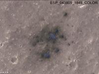
Post
#84
|
|
|
Member Group: Members Posts: 214 Joined: 30-December 05 Member No.: 628 |
What about the insulating effect of sand on heat flow? Ideally, wouldn't both the seismometer and the heat probe prefer not to be insulated from the bedrock by something porous and absorbent, like a layer of sand? The instruments may have been designed to see through a certain amount of softer material, but I don't see how it can fail to have some muffling effect.
We may hope that the ease-of-placement benefits of the sandy terrain can outweigh the sensitivity costs. |
|
|
|
|
Nov 30 2018, 03:05 AM
Post
#85
|
|
|
Member Group: Members Posts: 684 Joined: 24-July 15 Member No.: 7619 |
QUOTE (tanjent @ Nov 30 2018, 02:44 AM) wouldn't both the seismometer and the heat probe prefer not to be insulated from the bedrock by something porous and absorbent, like a layer of sand? As I understand it, Seis (seismometer) and Hp3 (heat probe) are optimal in opposite situations, but are both workable in the expected middle ground that insight actually got. The seismometer is designed to be supremely sensitive https://www.seis-insight.eu/en/public-2/sei...trument/summary Seems like that experiment wants no regolith to get best vibration, but they're confident that they can work with regolith. The heat probe is designed to burrow through up to 5 meters of regolith, then (perhaps) hits bedrock. https://www.seis-insight.eu/en/public-2/the...her-instruments That experiment WANTS a deep regolith to get heat flow numbers. |
|
|
|
|
Nov 30 2018, 04:03 AM
Post
#86
|
|
|
Member Group: Members Posts: 214 Joined: 30-December 05 Member No.: 628 |
Thanks!
Those are great articles - they really clarify a lot of issues I had been wondering about! |
|
|
|
|
Nov 30 2018, 11:31 AM
Post
#87
|
|
|
Newbie Group: Members Posts: 9 Joined: 27-February 12 Member No.: 6346 |
QUOTE (MahFL @ Nov 27 2018, 04:45 PM) The PI did say small rocks would be pushed aside by the Mole, but if it hit a big flat rock then that was as far as they could go, it won't go upwards. It's all about risk. In that context, I found this publication helpful (https://elib.dlr.de/121308/1/Spohn_et_al-20...nce_Reviews.pdf). I also wondered how well the mole would cope with any buried rocks. They say: QUOTE If the Mole encounters a rock larger than a few 10s of cm as it moves forward, it could be blocked from further advancement. The likelihood of such an encounter between the surface and the required (3 m) or target (5 m) depths has been calculated to be 43% and 59%, respectively. This estimate uses the most pessimistic models, [...] QUOTE If less conservative assumptions are made about surface rock abundance (e.g., 2.5% or less) and demonstrated capabilities of the Mole are allowed for (e.g., the Mole can push rocks up to 15 cm out of its way within the regolith, and can also deflect around rocks encountered at angles ≤45 degrees), the probability of success increases to 98% and 90%, respectively.
|
|
|
|
|
Nov 30 2018, 03:01 PM
Post
#88
|
|
 Junior Member Group: Members Posts: 30 Joined: 12-June 07 Member No.: 2392 |
QUOTE (PaulH51 @ Nov 29 2018, 04:47 PM) Does anyone know if they have an official mission clock for InSight? Similar to the one we have for Curiosity link that shows the sol and current solar time. I found and purchased ($0.99) the iPhone app "Mars-Clock" that has all this info. in detail for the current landed probes on Mars including InSight. It can be found on the app store -- be sure to look carefully as there are other similar apps available that (as of a few days ago) did not have info. for InSight. I'm not sure if there is anything on the web with this detailed info. or for other mobile platforms. |
|
|
|
|
Nov 30 2018, 05:21 PM
Post
#89
|
|
|
Member Group: Members Posts: 684 Joined: 24-July 15 Member No.: 7619 |
QUOTE (7B8 @ Nov 30 2018, 11:31 AM) QUOTE If the Mole encounters a rock larger than a few 10s of cm as it moves forward, it could be blocked from further advancement. The likelihood of such an encounter between the surface and the required (3 m) or target (5 m) depths has been calculated to be 43% and 59%, respectively. This estimate uses the most pessimistic models, ... You know, after reading that, deploying the seismometer first and then moving the probe around as a "thumper" to create a 3d map of the underground location of the big rocks you need to avoid, isn't such a crazy idea after all... |
|
|
|
| Guest_Steve5304_* |
Nov 30 2018, 05:21 PM
Post
#90
|
|
Guests |
We have never drilled more than a scratch under the surface. This is completely uncharted territory. Will the material in the well get analyzed?
Exciting stuff |
|
|
|
|
Nov 30 2018, 05:34 PM
Post
#91
|
|
|
Senior Member Group: Members Posts: 1729 Joined: 3-August 06 From: 43° 35' 53" N 1° 26' 35" E Member No.: 1004 |
QUOTE (Steve5304 @ Nov 30 2018, 06:21 PM) Will the material in the well get analyzed? nope. the mission is about seismology and heat balance, not about chemistry |
|
|
|
|
Nov 30 2018, 06:31 PM
Post
#92
|
|
 Martian Photographer Group: Members Posts: 352 Joined: 3-March 05 Member No.: 183 |
Since I didn't see a clock, I put this together. Should be within a second or so until the next leap second.
https://www.lpl.arizona.edu/~lemmon/mars-nsyt.html |
|
|
|
|
Nov 30 2018, 07:20 PM
Post
#93
|
|
|
Senior Member Group: Members Posts: 1583 Joined: 14-October 05 From: Vermont Member No.: 530 |
QUOTE (Steve5304 @ Nov 30 2018, 12:21 PM) We have never drilled more than a scratch under the surface. But trenching has been done. |
|
|
|
|
Nov 30 2018, 07:26 PM
Post
#94
|
|
|
Solar System Cartographer Group: Members Posts: 10162 Joined: 5-April 05 From: Canada Member No.: 227 |
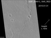
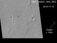
In my post on the second page of this thread I showed part of a HiRISE image in the area east of the target point, where I expected the lander to be. I have since learned that we are in fact west of the target, where the surface is a lot smoother than shown in that image. Can't be more specific now.
Phil -------------------- ... because the Solar System ain't gonna map itself.
Also to be found posting similar content on https://mastodon.social/@PhilStooke Maps for download (free PD: https://upload.wikimedia.org/wikipedia/comm...Cartography.pdf NOTE: everything created by me which I post on UMSF is considered to be in the public domain (NOT CC, public domain) |
|
|
|
| Guest_Steve5304_* |
Nov 30 2018, 07:34 PM
Post
#95
|
|
Guests |
QUOTE (stevesliva @ Nov 30 2018, 07:20 PM) But trenching has been done. yeah but not 16 feet. That's pretty deep, we might get some surprises |
|
|
|
|
Nov 30 2018, 08:03 PM
Post
#96
|
|
|
Member Group: Members Posts: 866 Joined: 15-March 05 From: Santa Cruz, CA Member No.: 196 |
QUOTE (HSchirmer @ Nov 30 2018, 09:21 AM) You know, after reading that, deploying the seismometer first and then moving the probe around as a "thumper" to create a 3d map of the underground location of the big rocks you need to avoid, isn't such a crazy idea after all... I was actually wondering if the system was designed to be able to "reel-in" the mole by its scientific tether to try a different location in case it were to meet criteria for mission failure by hitting an unmovable rock at too shallow a depth, but cant seem to find any mention of that, and seems highly risky anyways.. but on the other hand, such seismic imaging should also be possible by tapping the ground at strategic points with the deployment arm's bucket, or perhaps most safely by simply dropping scoops of regolith, no? |
|
|
|
|
Nov 30 2018, 08:04 PM
Post
#97
|
|
|
Senior Member Group: Members Posts: 2517 Joined: 13-September 05 Member No.: 497 |
QUOTE (nprev @ Nov 29 2018, 05:04 AM) The location 'race' is interesting... [deleted] -------------------- Disclaimer: This post is based on public information only. Any opinions are my own.
|
|
|
|
|
Nov 30 2018, 08:07 PM
Post
#98
|
|
|
Administrator Group: Admin Posts: 5172 Joined: 4-August 05 From: Pasadena, CA, USA, Earth Member No.: 454 |
Whoa!
-------------------- My website - My Patreon - @elakdawalla on Twitter - Please support unmannedspaceflight.com by donating here.
|
|
|
|
|
Nov 30 2018, 08:21 PM
Post
#99
|
|
|
Senior Member Group: Members Posts: 2517 Joined: 13-September 05 Member No.: 497 |
QUOTE (elakdawalla @ Nov 30 2018, 12:07 PM) Whoa! Keep in mind that the landing ellipse was several CTX swaths wide, so missing wouldn't be that surprising. -------------------- Disclaimer: This post is based on public information only. Any opinions are my own.
|
|
|
|
|
Dec 1 2018, 12:41 AM
Post
#100
|
|
|
Forum Contributor Group: Members Posts: 1372 Joined: 8-February 04 From: North East Florida, USA. Member No.: 11 |
|
|
|
|
 |

|
Lo-Fi Version | Time is now: 16th May 2024 - 07:01 AM |
|
RULES AND GUIDELINES Please read the Forum Rules and Guidelines before posting. IMAGE COPYRIGHT |
OPINIONS AND MODERATION Opinions expressed on UnmannedSpaceflight.com are those of the individual posters and do not necessarily reflect the opinions of UnmannedSpaceflight.com or The Planetary Society. The all-volunteer UnmannedSpaceflight.com moderation team is wholly independent of The Planetary Society. The Planetary Society has no influence over decisions made by the UnmannedSpaceflight.com moderators. |
SUPPORT THE FORUM Unmannedspaceflight.com is funded by the Planetary Society. Please consider supporting our work and many other projects by donating to the Society or becoming a member. |
|