Journey to Mt Sharp - Part 1: Site 7 to Waypoint 1, Sol324 [Jul4,'13] to Sol391 [Sep12,'13] |

  |
Journey to Mt Sharp - Part 1: Site 7 to Waypoint 1, Sol324 [Jul4,'13] to Sol391 [Sep12,'13] |
 Sep 4 2013, 08:44 PM Sep 4 2013, 08:44 PM
Post
#481
|
||
 Member  Group: Members Posts: 215 Joined: 23-October 12 From: Russia Member No.: 6725 |
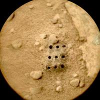
Pew-pew-pew at sol 382
 Ed, your anaglyphs are amazing!
Attached thumbnail(s)
-------------------- My blog on Patreon
|
|
 |
 
|
|
|
Sep 4 2013, 09:28 PM
Post
#482
|
|
|
Solar System Cartographer Group: Members Posts: 10145 Joined: 5-April 05 From: Canada Member No.: 227 |
"Ed, your anaglyphs are amazing!"
I second that emotion! Phil -------------------- ... because the Solar System ain't gonna map itself.
Also to be found posting similar content on https://mastodon.social/@PhilStooke NOTE: everything created by me which I post on UMSF is considered to be in the public domain (NOT CC, public domain) |
|
|
|
|
Sep 5 2013, 01:06 AM
Post
#483
|
|||
|
Member Group: Members Posts: 866 Joined: 15-March 05 From: Santa Cruz, CA Member No.: 196 |
lackluster attempt at stereo-resolving possible sol 382 'standing rock' (behind outcrop at top)
|
||
|
|
|
||
|
Sep 5 2013, 09:13 AM
Post
#484
|
|
|
Senior Member Group: Members Posts: 2346 Joined: 7-December 12 Member No.: 6780 |
QUOTE (atomoid @ Sep 5 2013, 03:06 AM)  perhaps a dual refraction ... Ad hoc, I'd say reflected sunlight looks more likely. |
|
|
|
|
Sep 5 2013, 03:03 PM
Post
#485
|
|
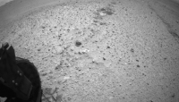
 Senior Member Group: Members Posts: 4246 Joined: 17-January 05 Member No.: 152 |
Yeah, those reflections have been visible in hazcam before. Can someone suggest what the reflecting surfaces are?
|
|
|
|
|
Sep 5 2013, 03:49 PM
Post
#486
|
||
|
Senior Member Group: Members Posts: 1074 Joined: 21-September 07 From: Québec, Canada Member No.: 3908 |
The road ahead (sol 383 pan):
|
|
|
|
|
|
|
Sep 5 2013, 03:54 PM
Post
#487
|
|
|
Founder Group: Chairman Posts: 14431 Joined: 8-February 04 Member No.: 1 |
QUOTE (fredk @ Sep 5 2013, 08:03 AM) Can someone suggest what the reflecting surfaces are? The arm, the rover chassis, the suspension, the organic blanks, the spare drill bits, the dust observing tray, the wheels. Some, one, none, or all of the above. |
|
|
|
|
Sep 5 2013, 04:11 PM
Post
#488
|
||
 Senior Member Group: Members Posts: 1465 Joined: 9-February 04 From: Columbus OH USA Member No.: 13 |
Some dune ripples on the right:
-------------------- |
|
|
|
|
|
|
Sep 5 2013, 05:28 PM
Post
#489
|
|
|
Senior Member Group: Members Posts: 4246 Joined: 17-January 05 Member No.: 152 |
QUOTE (djellison @ Sep 5 2013, 03:54 PM) The arm, the rover chassis, the suspension, the organic blanks, the spare drill bits, the dust observing tray, the wheels. Knowledge of the time the hazcams were taken will tell you where the Sun was. With some basic geometry, that would let you recover the orientation of the reflecting surfaces. That should narrow it down. |
|
|
|
|
Sep 5 2013, 06:22 PM
Post
#490
|
|
 Member Group: Members Posts: 222 Joined: 7-August 12 From: Garberville, CA Member No.: 6500 |
Closing in on "Waypoint #1"...
According to JPL's recently published Route Map we should now be some 300 meters or so away from the first geologic waypoint. The green triangle identifying it on their map is centered just to the west of the large depression at the bottom of the maps below (Phil's "Outcrop 1"). Here's a full resolution anaglyph (and reduced resolution cross-eye version) covering the terrain between our current position and the waypoint area. Though I added color, the anaglyph has not been reduced from the 29cm per pixel HIRISE JP2 master. The cross eye version has been reduced to about about 50cm per pixel. As Emily had pondered a while ago, I wonder which of the several bright outcrops in this area they'll be focusing on? There are two distinct light toned features to the west and NW of the depression. Perhaps one of those? There looks to be some really interesting geology in the depression too, and given the stereo elevation is slightly exaggerated, it looks like there might be few theoretically "safe" paths into it as well. g Anaglyph - 2064 x 2292 pixels:  X-Eye Version - 1169 x 915 pixels:  Edit: ...and for good measure here's a slightly higher resolution cross-eye version close-up of the waypoint area only (1800 x 743 pixels). Should be a about 35cm per pixel I figure.... 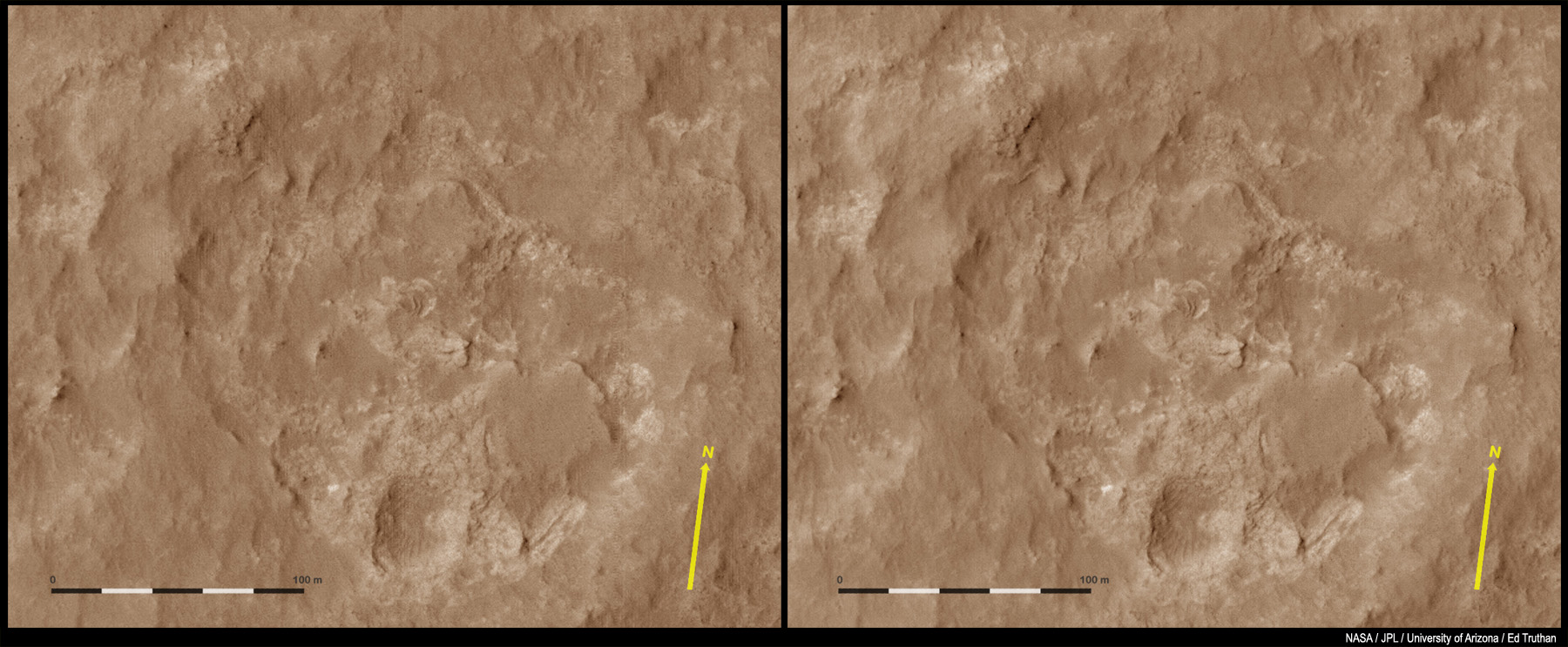
-------------------- "We shall not cease from exploration, and the end of all our exploring will be to arrive where we started and know the place for the first time." -T.S. Eliot
|
|
|
|
|
Sep 5 2013, 10:57 PM
Post
#491
|
|
|
Solar System Cartographer Group: Members Posts: 10145 Joined: 5-April 05 From: Canada Member No.: 227 |
Another drive on 385.
Hey, I'm a poet and didn't know it. Looks like it little west of south but maybe I'm just flapping my mouth. Tomorrow I'll update my map, but now I've gotta ... case of poet's block. Phil -------------------- ... because the Solar System ain't gonna map itself.
Also to be found posting similar content on https://mastodon.social/@PhilStooke NOTE: everything created by me which I post on UMSF is considered to be in the public domain (NOT CC, public domain) |
|
|
|
|
Sep 5 2013, 11:43 PM
Post
#492
|
|
|
Senior Member Group: Members Posts: 1465 Joined: 9-February 04 From: Columbus OH USA Member No.: 13 |
144 meters? It's a new record. The USGS blog said they were going for 100 meters with an autonav portion at the end. Looks like that's what happened:
Sol 385, 144 meters Also, a decided turn to the south, towards that region of geological interest. -------------------- |
|
|
|
|
Sep 6 2013, 12:14 AM
Post
#493
|
|
 Senior Member Group: Moderator Posts: 3431 Joined: 11-August 04 From: USA Member No.: 98 |
Just an amazing drive; 132.5m direct, over hills! Usually the tracking data needs to be taken with a large grain of salt, but in this case, judging by the dusty patch to the left of Curiosity's stopping point, it seems (maybe) to be about right to me. These images link to Flickr.
|
|
|
|
|
Sep 6 2013, 12:31 AM
Post
#494
|
|
|
Senior Member Group: Members Posts: 1465 Joined: 9-February 04 From: Columbus OH USA Member No.: 13 |
Rover driver @Matt_Heverly tweeted this:

-------------------- |
|
|
|
|
Sep 6 2013, 01:23 AM
Post
#495
|
|
|
Member Group: Members Posts: 222 Joined: 7-August 12 From: Garberville, CA Member No.: 6500 |
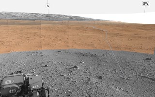
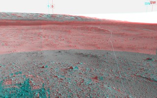
Sol 385 - Basin dead ahead - and I'll be doggone. What a nice drive. Judging from the position on Joe's Map then we ought to be overlooking the big basin, and sure enough - it's dead ahead and completely visible below us. Even from this distance the geology down there looks pretty interesting. The anaglyph really shows off the elevation drop ahead...
Sol 385 - 2-D full frame NRB: .jpg) Sol 385 - Anaglyph bottom cropped:  ...and mhoward - placing the MC's over the Navs and tracing that path - nicely done. -------------------- "We shall not cease from exploration, and the end of all our exploring will be to arrive where we started and know the place for the first time." -T.S. Eliot
|
|
|
|
|

|
Lo-Fi Version | Time is now: 16th April 2024 - 04:30 AM |
|
RULES AND GUIDELINES Please read the Forum Rules and Guidelines before posting. IMAGE COPYRIGHT |
OPINIONS AND MODERATION Opinions expressed on UnmannedSpaceflight.com are those of the individual posters and do not necessarily reflect the opinions of UnmannedSpaceflight.com or The Planetary Society. The all-volunteer UnmannedSpaceflight.com moderation team is wholly independent of The Planetary Society. The Planetary Society has no influence over decisions made by the UnmannedSpaceflight.com moderators. |
SUPPORT THE FORUM Unmannedspaceflight.com is funded by the Planetary Society. Please consider supporting our work and many other projects by donating to the Society or becoming a member. |
|