The Geology of Jezero Crater, Observations & Findings |

  |
The Geology of Jezero Crater, Observations & Findings |
 Feb 25 2021, 12:48 AM Feb 25 2021, 12:48 AM
Post
#16
|
|
 Member  Group: Members Posts: 684 Joined: 24-July 15 Member No.: 7619 |
QUOTE (JRehling @ Feb 24 2021, 09:55 PM)  What we see now in the near distance is not thought to be sedimentary layers formed in the lake. Agreed - I was thinking about the delta and Van Houten cycles. QUOTE (Cyclicity @ Climate , and Time scales") Orbital forcing in the Newark basin is revealed as a hierarchy of lake level cycles that controlled by precipitation and evaporation changes controlled by precession-related celestial mechanical cycles.
 https://www.ldeo.columbia.edu/~polsen/nbcp/cyclcicity.html |
 |
 
|
|
Feb 25 2021, 02:16 AM
Post
#17
|
|
|
Senior Member Group: Members Posts: 1043 Joined: 17-February 09 Member No.: 4605 |
The consensus seems to be that the crater floor was flooded by lava some 300 million years after the lake dried up which embayed sedimentary/deltaic deposits. There has been some erosion of the delta material since then so a proportion of the aeolian deposit that JRehling noted drapes underlying topography could well be of deltaic origin. The area west of the Isidis basin, including Jezero crater reveals olivine‐carbonate lithology; in Jezero crater concentrated at the Western rim with some deposits in the delta. Given the dearth of carbonates elsewhere despite what seems to have been plentiful water in a CO2 atmosphere it will be really interesting if Perseverance can determine why it was preserved in this particular area.
JRehling...." I think we're going to learn about the nature of a sort of "impact gardening" that took place on a massive scale on Mars." Most possible, but using that term here is akin to lighting a blue touch paper. |
|
|
|
|
Feb 25 2021, 04:29 PM
Post
#18
|
||
 Senior Member Group: Members Posts: 2530 Joined: 20-April 05 Member No.: 321 |
One detail in the Sol 3 panorama that's especially informative is the northernmost (furthest right) delta face. I cropped it and moreover turned up contrast in the red channel to bring out a subtle color contrast.
The first thing I notice is that here, as elsewhere, the delta's eastern slopes are mainly smooth, with the expected sedimentary layers covered. The layers are visible, though, more than in other places in the delta. The route plans we've seen would never bring Perseverance close to this area, instead heading well south, where outcroppings are from the landing site hard to see. The mission team may gamble that with any route that ascends the delta, the layers will nonetheless make themselves apparent closer up. I'm also struck by the fact that the layers are not horizontal. There has been tilting since the lake dried up. My manipulation of the color contrast was intended to explore the smooth mantling of the delta slope, and I think the patchy variation speaks to two types of material. The darker, greener material appears to be talus derived from the delta itself, while the brighter, redder material is the global coating of dust, which is universally present in this photo in the near distance, the far distance, and atop the delta. What's not clear is how much the contrast seen in the patchiness has to do with changes in texture versus abundance of one material versus the other, but that may be one and the same: Where larger pieces of talus exist, we see the rough sides of them, and elsewhere, the global dust unit covers it up. As Perseverance approaches the delta, we will begin to see more pieces of the delta that moved downslope. However, the area just east of and below the delta will likely be a jumble of pieces from different layers, and while each of those rocks will be individually interesting, the jumbling will deny us information about which piece came from which layer, and may be something the mission planners choose to move past fairly quickly, opting to get sooner up and to the layers themselves, where each unit studied will come with the context provided of which unit in the delta is that unit's home.
Attached thumbnail(s)
|
|
|
|
|
|
|
Feb 25 2021, 06:15 PM
Post
#19
|
|
|
Member Group: Members Posts: 684 Joined: 24-July 15 Member No.: 7619 |
QUOTE (JRehling @ Feb 25 2021, 04:29 PM) I'm also struck by the fact that the layers are not horizontal. There has been tilting since the lake dried up. Most river delta deposits slope downward when they hit a much larger lake or ocean. Similarly, the first sediment to drop out of the current is the heaviest- the largest and most incompressible gravel and grit. The further from the delta mouth you get, the finer, and more "hydrated" the sediment becomes. When the delta is eventually compressed or dries out, there's more "shrinkage" in the more distant sediment beds. |
|
|
|
|
Feb 26 2021, 09:44 PM
Post
#20
|
|
|
Member Group: Members Posts: 248 Joined: 25-February 21 From: Waltham, Massachussetts, U.S.A. Member No.: 8974 |
Delta erosion
At distances of a few hundered meters to a kilometer away from the current edge of the main delta deposits, there are a few isolated hills which could be classified as Inselbergs or outliers. Here is an example: https://mars.nasa.gov/maps/location/?mission=M20&site=jez&mapLon=77.40930318832399&mapLat=18.444092466139594&mapZoom=15&globeLon=77.42958068847659&globeLat=18.463327291058505&globeZoom=12&globeCamera=0,-4882.8125,0,0,1,0&panePercents=0,100,0&on=Current Position$1.00,Waypoints$1.00,Surface View$1.00,Landing Ellipse$1.00,Rover Path$1.00,Labels$1.00,Basemap$1.00,North East Syrtis Base Map$1.00://https://mars.nasa.gov/maps/location...e Map$1.00 A typical, geological interpretation of such isolated hills is that they were once connected to a main, better preserved area, here the delta, and became disconnected by erosion. The Inselbergs would be therefore witnesses to a former, larger extent of the delta, and in german such features are called Zeugenberg (witness = Zeuge). Given the similar appearance in terms of height and a flat top and a spatial correlation with the edge of the delta, this to me would be the preferred interpretation of the formation of this hills. This could be tested by examining the local stratigraphy of the delta and the hills with the expectation that there should be a good match. If this is the case, the delta was eroded back from its largest extent. This is to be expected during the time when the lake started to retreat to below delta levels. The current, abrupt edge of the delta is also more likely to have been shaped by erosion than being an original feature. Growing deltas tend to taper out into deeper water and transition into fans, leading to gentle slopes of a few degrees. One question then becomes where did the significant mass of eroded delta sediments go ? Perhaps there have been mass balance studies but one possible candidate is the smoother appearing material covering the plane just below the slope of the delta in a ring a few km wide in places. This ring appears to be less cratered than the center of the crater. Following the discussion it is also possible that the youngest sediments now are exclusively aeolian, and from impact dust and debris, and that eroded, reworked, and redeposited delta sediments are completely hidden below a top soil, accreted layer. And beneath both of those, there could be original lake bottom sediments. So it may make sense to investigate the craters closer to the rover which could have excavated deeper lake bottom sediments. But the safest place to get fluvial, water dominated, pristine material for sampling is probably right at the face of the current edge of the delta. A few thoughts, mainly on the importance of the outliers surrounding the current delta. -------------------- --
Andreas Plesch, andreasplesch at gmail dot com |
|
|
|
|
Feb 26 2021, 11:37 PM
Post
#21
|
|
|
Member Group: Members Posts: 684 Joined: 24-July 15 Member No.: 7619 |
QUOTE (Andreas Plesch @ Feb 26 2021, 10:44 PM) Delta erosion Excellent summary.... A few thoughts, mainly on the importance of the outliers surrounding the current delta. So, have any graduate students made a vacuum-formed crater and experimented with filling it with sediments and varying the water / sediment ratio to see what it takes to recreate the delta? (Asking as "that kid" who filled the little red wagon with cement, sand & stone, dropped marbles to create craters for an "authentic" moonscape for the Mattel 'Space 1999 Eagle' to land on...) |
|
|
|
|
Feb 27 2021, 12:00 AM
Post
#22
|
||
|
Senior Member Group: Members Posts: 1043 Joined: 17-February 09 Member No.: 4605 |
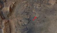
Good post Andreas. The isolated hills have been nominated by some as delta remnants although I haven't been able to find confirmation that their minerology matches the delta. If they are remnants then the erosion between them and the delta must have occurred in the (geologically short) gap between the crater drying and the lava flood. The attached image shows that the lava embayed the delta and I have marked what may be an example of embayed delta material eroding down below the lava level. But the lava would have covered the delta bottom sets and part of the foresets, preventing further erosion of the lighter materials. Jezero is a big crater and aeolian eroded material from the delta would not be particularly evident.
Attached thumbnail(s)
|
|
|
|
|
|
|
Feb 27 2021, 12:41 AM
Post
#23
|
|||
|
Member Group: Members Posts: 684 Joined: 24-July 15 Member No.: 7619 |
QUOTE (serpens @ Feb 27 2021, 12:00 AM) If they are remnants then the erosion between them and the delta must have occurred in the (geologically short) gap between the crater drying and the lava flood. Question- why couldn't that be later aeolian weathering? Similar to what roto-rootered away hundreds of meters / yards of sediment at Gale crater? Is there a consensus about whether the deposit is ash, (dry then flooded, or deposited in a lake) or extrusive lava?
Attached thumbnail(s)
|
||
|
|
|
||
|
Feb 27 2021, 02:20 AM
Post
#24
|
|
|
Member Group: Members Posts: 248 Joined: 25-February 21 From: Waltham, Massachussetts, U.S.A. Member No.: 8974 |
QUOTE (HSchirmer @ Feb 26 2021, 07:41 PM) Question- why couldn't that be later aeolian weathering? Similar to what roto-rootered away hundreds of meters / yards of sediment at Gale crater? Is there a consensus about whether the deposit is ash, (dry then flooded, or deposited in a lake) or extrusive lava? Well, I admit I did not take a detailed look at the latest geologic map, linked above, before. But it more or less confirms a few of my assumptions. The outliers are indeed mapped as the same unit (NHjf2, Jezero fan unit 2) as the main delta, and it explains that the Jezero floor unit (Njf) is covered near the delta by a smooth layer: "Dark, smooth surface texture near unit NHjf2 is due to a dark mantle deposit or erosional lag derived from erosion of unit NHjf2.". The Jezero floor unit itself is revised from lava flood flow to ash and/or aeolian airfall deposits (not sure if that was by consens), and is older than the delta, but still seen as lacustrine, so possibly deeper water deposits. In addition there should also be clastic, distal flan floor deposits. These may have been mostly muddy and as such more easily blown away once the lake bed was exposed as they are not to be found. The floor unit then embays and sits above the Lower etched unit, also seen as volcanic ash falling into the lake. Thanks, serpens, for pointing out that nice contact. It looks to me like an erosional window into that deeper unit which is also lacustrine. Delta erosion could have occurred by water in the manner of retreating waterfalls which is geologically efficient and does not take much geologic time (cm to m per year if water is regularly flowing). [Still strange to me looking at preserved billions of years old units, possible on a planet without plate tectonics which just sits there.] The geologic map shows hills or outliers about 2km to the _east_ of the rover, as Jezero fan unit 2, farther from the delta as I first thought. This would mean that the delta was perhaps about double the radial length, or 4 times the area (and volume and mass ignoring changes in thickness), at an earlier point than what remains today. Hard to see that all that eroded material could have been transported very far away but it looks like it could have been. perhaps even out of the crater into the regional sink, Isidis Planitia ? The nice lobes of the delta as seen today could have been preserved by preferential erosion preserving orginally larger lobes. Perhaps the outliers are remnants of just the larger lobes reaching out into the basin. -------------------- --
Andreas Plesch, andreasplesch at gmail dot com |
|
|
|
|
Feb 27 2021, 03:28 AM
Post
#25
|
|
|
Senior Member Group: Members Posts: 1043 Joined: 17-February 09 Member No.: 4605 |
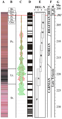
The possibility that the mafic floor unit is sedimentary has been floated for some time but the general consensus is that it is a volcanic deposit. As with Curiosity I am sure that Perseverance will clarify satellite assessments of this part of Jezero. Shahrzad et al. Crater Statistics on the Dark‐Toned, Mafic Floor Unit in Jezero Crater, Mars (Geophysical Research Letters) determined the average thickness of this deposit at the margins to be ~13.0 ± 0.8 m. https://www.hou.usra.edu/meetings/lpsc2020/pdf/1608.pdf raises the possibility that it could be pyroclastic rather than effusive.
HSchirmer's question on whether the gap between outliers and the delta could be later aeolian erosional is well taken. My take is that if this were so then the mafic deposit would have embayed the area rather than covering it. However we will probably need to wait for next years LPC to get Perseverance's analysis. |
|
|
|
|
Feb 27 2021, 01:33 PM
Post
#26
|
|
|
Member Group: Members Posts: 684 Joined: 24-July 15 Member No.: 7619 |
QUOTE (serpens @ Feb 27 2021, 03:28 AM) The possibility that the mafic floor unit is sedimentary has been floated for some time I guess that's where we're talking past each other - I'm thinking of ashfall into a lake as sedimentary, I seems like you're considering ashfall as volcanic? I have to admit, that's a tough call to make... QUOTE UNDERSTANDING THE CONTINUITY OF REGIONAL UNITS IN THE MARS 2020 JEZERO AND NORTHEAST SYRTIS REGIONS: IMPLICATIONS FOR THE ORIGIN OF THE MAFIC UNIT(S). 50th Lunar and Planetary Science Conference 2019 (LPI Contrib. No. 2132) "If so, the presence of this mafic unit across a large regional extent and its draping occurrence on topographic slopes (especially on Jezeros rim) is highly suggestive of clastic deposition, perhaps via airfall, rather than by a volcanic flow origin." "If the mafic unit is indeed the same unit at both NE Syrtis and Jezero, then this would likely preclude a volcanic flow origin n3 and instead favor a draping emplacement mechanism, such as ashfall deposition or other clastic sedimentary mechanism. " https://www.hou.usra.edu/meetings/lpsc2019/pdf/2271.pdf |
|
|
|
|
Feb 27 2021, 04:47 PM
Post
#27
|
|
|
Member Group: Members Posts: 154 Joined: 8-June 04 Member No.: 80 |
Does anyone know which rock Perseverance will examine first? Could it be the one with the "holes" in it right next to one of its wheels?
|
|
|
|
|
Feb 27 2021, 05:22 PM
Post
#28
|
|
|
Solar System Cartographer Group: Members Posts: 10153 Joined: 5-April 05 From: Canada Member No.: 227 |
No news on that yet. Things are just ramping up after the software switch so we will see soon.
Phil -------------------- ... because the Solar System ain't gonna map itself.
Also to be found posting similar content on https://mastodon.social/@PhilStooke Maps for download (free PD: https://upload.wikimedia.org/wikipedia/comm...Cartography.pdf NOTE: everything created by me which I post on UMSF is considered to be in the public domain (NOT CC, public domain) |
|
|
|
|
Feb 27 2021, 05:38 PM
Post
#29
|
||
|
Member Group: Members Posts: 311 Joined: 31-August 05 From: Florida & Texas, USA Member No.: 482 |
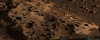
This image was cropped from the mastcam-z pan. It appears the wind scouring of the "holey rocks" at the base of the rover show a prevailing direction occurred for a long period of time. If aeolian deflation of the delta occurred, then the sediments likely were deposited in that direction. If the hardness of the holey rocks and delta deposits can be assessed, then the total mass lost to erosion would have an estimate. I also wonder if the wind helped scour some of those holes larger? |
|
|
|
|
|
|
Feb 27 2021, 07:24 PM
Post
#30
|
||
|
Member Group: Members Posts: 248 Joined: 25-February 21 From: Waltham, Massachussetts, U.S.A. Member No.: 8974 |
QUOTE (Marz @ Feb 27 2021, 12:38 PM)
This image was cropped from the mastcam-z pan. It appears the wind scouring of the "holey rocks" at the base of the rover show a prevailing direction occurred for a long period of time. If aeolian deflation of the delta occurred, then the sediments likely were deposited in that direction. If the hardness of the holey rocks and delta deposits can be assessed, then the total mass lost to erosion would have an estimate. I also wonder if the wind helped scour some of those holes larger? Vesicular basalt can look a bit like the holey rocks: _(14838828059).jpg/640px-thumbnail.jpg) This example is from Hawaii and also has some Olivine in it. The texture is quite common in basalts and less common in pyroclastic deposits. The holes are trapped gas bubbles forming during degassing. Pumice would be an extreme example. I think these holey rocks would make an attractive target for testing all the instruments. Not sure if similarly textured rocks had been observed before and they seem to be in-situ, eg. bedrock which would help with understanding the mapped unit as a whole. -------------------- --
Andreas Plesch, andreasplesch at gmail dot com |
|
|
|
|
|
|

|
Lo-Fi Version | Time is now: 27th April 2024 - 12:32 PM |
|
RULES AND GUIDELINES Please read the Forum Rules and Guidelines before posting. IMAGE COPYRIGHT |
OPINIONS AND MODERATION Opinions expressed on UnmannedSpaceflight.com are those of the individual posters and do not necessarily reflect the opinions of UnmannedSpaceflight.com or The Planetary Society. The all-volunteer UnmannedSpaceflight.com moderation team is wholly independent of The Planetary Society. The Planetary Society has no influence over decisions made by the UnmannedSpaceflight.com moderators. |
SUPPORT THE FORUM Unmannedspaceflight.com is funded by the Planetary Society. Please consider supporting our work and many other projects by donating to the Society or becoming a member. |
|