MSL Route Map |

  |
MSL Route Map |
 May 6 2015, 05:22 PM May 6 2015, 05:22 PM
Post
#601
|
||
|
Solar System Cartographer  Group: Members Posts: 10172 Joined: 5-April 05 From: Canada Member No.: 227 |
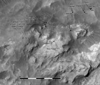
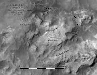
And now we have run off. Update to sol 976... I moved the name Mt. Shields up onto the ridge to match the latest map from Fred Calef at JPL. As usual, the position should be pretty good, but the route is only a guess so far.
Phil
-------------------- ... because the Solar System ain't gonna map itself.
Also to be found posting similar content on https://mastodon.social/@PhilStooke Maps for download (free PD: https://upload.wikimedia.org/wikipedia/comm...Cartography.pdf NOTE: everything created by me which I post on UMSF is considered to be in the public domain (NOT CC, public domain) |
|
 |
 
|
|
|
May 8 2015, 07:33 AM
Post
#602
|
||
|
Solar System Cartographer Group: Members Posts: 10172 Joined: 5-April 05 From: Canada Member No.: 227 |
A short drive on sol 978.
Phil
-------------------- ... because the Solar System ain't gonna map itself.
Also to be found posting similar content on https://mastodon.social/@PhilStooke Maps for download (free PD: https://upload.wikimedia.org/wikipedia/comm...Cartography.pdf NOTE: everything created by me which I post on UMSF is considered to be in the public domain (NOT CC, public domain) |
|
|
|
|
|
|
May 9 2015, 12:10 AM
Post
#603
|
|
 Member Group: Members Posts: 912 Joined: 15-June 09 From: Lisbon, Portugal Member No.: 4824 |
Update to Sol 978. Added a few names and the 11km mark to the [hidden] milestones from curiosityrover.com
Fernando  MSL_Curiosity_Route_Map_Sol_0978_2015MAY09.kmz ( 248.97K )
Number of downloads: 320
MSL_Curiosity_Route_Map_Sol_0978_2015MAY09.kmz ( 248.97K )
Number of downloads: 320 |
|
|
|
|
May 9 2015, 02:08 PM
Post
#604
|
||
|
Solar System Cartographer Group: Members Posts: 10172 Joined: 5-April 05 From: Canada Member No.: 227 |
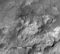
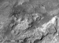
Here's an update - correcting the drive on sol 976 and adding some names. Oh - and moving West Ridge to the place i now think it should be.
Phil
-------------------- ... because the Solar System ain't gonna map itself.
Also to be found posting similar content on https://mastodon.social/@PhilStooke Maps for download (free PD: https://upload.wikimedia.org/wikipedia/comm...Cartography.pdf NOTE: everything created by me which I post on UMSF is considered to be in the public domain (NOT CC, public domain) |
|
|
|
|
|
|
May 11 2015, 09:42 AM
Post
#605
|
||
|
Solar System Cartographer Group: Members Posts: 10172 Joined: 5-April 05 From: Canada Member No.: 227 |
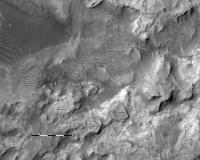
Update to sol 981 to show a 16 m drive through Jocko Chute.
Phil
-------------------- ... because the Solar System ain't gonna map itself.
Also to be found posting similar content on https://mastodon.social/@PhilStooke Maps for download (free PD: https://upload.wikimedia.org/wikipedia/comm...Cartography.pdf NOTE: everything created by me which I post on UMSF is considered to be in the public domain (NOT CC, public domain) |
|
|
|
|
|
|
May 13 2015, 09:31 AM
Post
#606
|
||
|
Solar System Cartographer Group: Members Posts: 10172 Joined: 5-April 05 From: Canada Member No.: 227 |
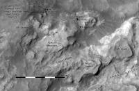
Sol 983 - now we are through the chute and facing the rocky outcrops a bit to the west of the target area.
Phil
-------------------- ... because the Solar System ain't gonna map itself.
Also to be found posting similar content on https://mastodon.social/@PhilStooke Maps for download (free PD: https://upload.wikimedia.org/wikipedia/comm...Cartography.pdf NOTE: everything created by me which I post on UMSF is considered to be in the public domain (NOT CC, public domain) |
|
|
|
|
|
|
May 14 2015, 10:14 AM
Post
#607
|
||
|
Solar System Cartographer Group: Members Posts: 10172 Joined: 5-April 05 From: Canada Member No.: 227 |
A short drive on sol 984, getting around the bad bit of drift.
Phil
-------------------- ... because the Solar System ain't gonna map itself.
Also to be found posting similar content on https://mastodon.social/@PhilStooke Maps for download (free PD: https://upload.wikimedia.org/wikipedia/comm...Cartography.pdf NOTE: everything created by me which I post on UMSF is considered to be in the public domain (NOT CC, public domain) |
|
|
|
|
|
|
May 14 2015, 03:21 PM
Post
#608
|
|
|
Member Group: Members Posts: 362 Joined: 13-April 06 From: Malta Member No.: 741 |
Hope this is the correct channel but has it been determined at what elevation is yellow knife bay compared to the current rover position in relation to the washboard and Murray formation units?
|
|
|
|
|
May 14 2015, 09:53 PM
Post
#609
|
|
|
Member Group: Members Posts: 866 Joined: 15-March 05 From: Santa Cruz, CA Member No.: 196 |
that should be abel to be determined using Joe's drive log. please let us know what you find.
|
|
|
|
|
May 14 2015, 10:38 PM
Post
#610
|
|
|
Member Group: Members Posts: 910 Joined: 4-September 06 From: Boston Member No.: 1102 |
What happen to Joe's map. It still includes a bogus leg and is now hundreds of meters off?
-------------------- |
|
|
|
|
May 15 2015, 09:19 PM
Post
#611
|
|
|
Member Group: Members Posts: 912 Joined: 15-June 09 From: Lisbon, Portugal Member No.: 4824 |
QUOTE (Julius @ May 14 2015, 04:21 PM)  ... at what elevation is yellow knife bay compared to the current rover position ... I think I can answer that bit. Using the Google Earth (Mars) elevation profile on the path I regularly put out, I find a difference of -1m to -2m between Yellowknife Bay and the Sol 0984 location. Fernando |
|
|
|
|
May 15 2015, 09:43 PM
Post
#612
|
|
|
Member Group: Members Posts: 912 Joined: 15-June 09 From: Lisbon, Portugal Member No.: 4824 |
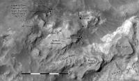
Update to Sol 984.
Fernando
MSL_Curiosity_Route_Map_Sol_0984_2015MAY15.kmz ( 249.23K )
Number of downloads: 530 |
|
|
|
|
May 15 2015, 11:02 PM
Post
#613
|
|
 Senior Member Group: Members Posts: 1641 Joined: 5-March 05 From: Boulder, CO Member No.: 184 |
It seems like Joe's log would indicate (despite its present horizontal offset) around a 90m climb since Yellowknife to the current position, so I wonder if there is a discrepancy somewhere?
-------------------- Steve [ my home page and planetary maps page ]
|
|
|
|
|
May 16 2015, 12:57 AM
Post
#614
|
|
 Senior Member Group: Members Posts: 2429 Joined: 30-January 13 From: Penang, Malaysia. Member No.: 6853 |
QUOTE (nogal @ May 16 2015, 05:43 AM) Update to Sol 984. Many thanks to Fernando for the updated kmz file  However, I think we should use caution when using the Google Earth (Mars) elevation data. In my experience it is somewhat inaccurate when compared with the contour maps published here from time to time by Joe and then overlaid by Phil. I find these very useful. However, I think we should use caution when using the Google Earth (Mars) elevation data. In my experience it is somewhat inaccurate when compared with the contour maps published here from time to time by Joe and then overlaid by Phil. I find these very useful.I also look forward to seeing more contour maps that address the path in front of the rover like this recent one from JPL (Fred) LINK which gives us 2 meter contour lines, based on the HiRISE DEM tied to MOLA. |
|
|
|
|
May 16 2015, 11:48 AM
Post
#615
|
||
|
Solar System Cartographer Group: Members Posts: 10172 Joined: 5-April 05 From: Canada Member No.: 227 |
A short move back on sol 986.
Phil
-------------------- ... because the Solar System ain't gonna map itself.
Also to be found posting similar content on https://mastodon.social/@PhilStooke Maps for download (free PD: https://upload.wikimedia.org/wikipedia/comm...Cartography.pdf NOTE: everything created by me which I post on UMSF is considered to be in the public domain (NOT CC, public domain) |
|
|
|
|
|
|

|
Lo-Fi Version | Time is now: 29th May 2024 - 06:16 PM |
|
RULES AND GUIDELINES Please read the Forum Rules and Guidelines before posting. IMAGE COPYRIGHT |
OPINIONS AND MODERATION Opinions expressed on UnmannedSpaceflight.com are those of the individual posters and do not necessarily reflect the opinions of UnmannedSpaceflight.com or The Planetary Society. The all-volunteer UnmannedSpaceflight.com moderation team is wholly independent of The Planetary Society. The Planetary Society has no influence over decisions made by the UnmannedSpaceflight.com moderators. |
SUPPORT THE FORUM Unmannedspaceflight.com is funded by the Planetary Society. Please consider supporting our work and many other projects by donating to the Society or becoming a member. |
|