Moon Images By SMART-1 |

  |
Moon Images By SMART-1 |
 Mar 4 2008, 04:49 PM Mar 4 2008, 04:49 PM
Post
#106
|
||
|
Solar System Cartographer  Group: Members Posts: 10160 Joined: 5-April 05 From: Canada Member No.: 227 |
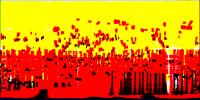
Here's a map of SMART-1 coverage by resolution. Yellow is coverage better than 250 m/pixel, essentialy global. Red is better than 100 m/pixel, most of the southern hemisphere. Black is better than 50 m/pixel. The central longitude of the map is zero degrees, the ends are 180 degrees, north at top.
And goodish news - the images themselves are still being worked on for ingestion into the PSA, ESA's version of PDS. So we will get them eventually. I understand that calibration has been difficult because camera properties changed during the mission. Phil
-------------------- ... because the Solar System ain't gonna map itself.
Also to be found posting similar content on https://mastodon.social/@PhilStooke Maps for download (free PD: https://upload.wikimedia.org/wikipedia/comm...Cartography.pdf NOTE: everything created by me which I post on UMSF is considered to be in the public domain (NOT CC, public domain) |
|
 |
 
|
|
|
Mar 4 2008, 04:56 PM
Post
#107
|
||
|
Solar System Cartographer Group: Members Posts: 10160 Joined: 5-April 05 From: Canada Member No.: 227 |
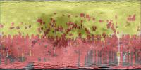
And here it is with a Clementine mosaic overlay.
Phil
-------------------- ... because the Solar System ain't gonna map itself.
Also to be found posting similar content on https://mastodon.social/@PhilStooke Maps for download (free PD: https://upload.wikimedia.org/wikipedia/comm...Cartography.pdf NOTE: everything created by me which I post on UMSF is considered to be in the public domain (NOT CC, public domain) |
|
|
|
|
|
|
Sep 27 2010, 09:49 AM
Post
#108
|
|
|
Newbie Group: Members Posts: 6 Joined: 11-April 09 From: Sweden Member No.: 4726 |
Emily noted that the SMART-1 data has been released:
http://sci.esa.int/science-e/www/object/in...fobjectid=47714 QUOTE The complete archive of data sets from ESA's 3-year SMART-1 mission to the Moon has been released to the scientific community. I have just started to look around in the archive, but it looks like a huge FTP archve with files like: File:AMI_EE7_031003_00004_01000.IMG 292 KB 07/08/2010 12:37:00 PM File:AMI_EE5_031003_00002_00010.IMG 164 KB 07/08/2010 12:42:00 PM File:AMI_EE3_031003_00005_10000.IMG 548 KB 07/08/2010 12:51:00 PM File:AMI_EE7_031003_00001_00010.IMG 292 KB 07/08/2010 12:53:00 PM I do not yet have any personal experience with processing raw data, but it would be fun to be able to browse these images. CODE PDS_VERSION_ID = PDS3 /*** FILE CHARACTERISTICS ***/ FILE_NAME = "AMI_EE1_031003_00001_00010.IMG" RECORD_TYPE = FIXED_LENGTH RECORD_BYTES = 1024 FILE_RECORDS = 292 LABEL_RECORDS = 20 INTERCHANGE_FORMAT = BINARY So I guess that it's just a matter of dig into the documentation or wait for someone here to point out what tools are available. |
|
|
|
|
Sep 27 2010, 10:25 AM
Post
#109
|
|
 Senior Member Group: Members Posts: 3648 Joined: 1-October 05 From: Croatia Member No.: 523 |
There are both raw and calibrated products available. However, the way the metadata is organized makes it a pain to see which image was taken when and of what target. The browse thumbnails seem to be actually imbedded inside the IMGs so that's not really helpful. Also, the calibrated products seem to be missing all the lunar phase images that also show Earth in the FOV, in fact entire such orbits of interest are missing from the calibrated products.
-------------------- |
|
|
|
|
Sep 27 2010, 03:20 PM
Post
#110
|
|
|
Solar System Cartographer Group: Members Posts: 10160 Joined: 5-April 05 From: Canada Member No.: 227 |
Yes, I don't get that browse image thing at all. Let's have a folder of browse images, and a clickable map interface!
Phil -------------------- ... because the Solar System ain't gonna map itself.
Also to be found posting similar content on https://mastodon.social/@PhilStooke Maps for download (free PD: https://upload.wikimedia.org/wikipedia/comm...Cartography.pdf NOTE: everything created by me which I post on UMSF is considered to be in the public domain (NOT CC, public domain) |
|
|
|
|
Sep 27 2010, 05:09 PM
Post
#111
|
||
|
Senior Member Group: Members Posts: 3648 Joined: 1-October 05 From: Croatia Member No.: 523 |
Here's a Moon approach sequence of 13 images. Supposedly shows the north pole.
-------------------- |
|
|
|
|
|
|
Sep 28 2010, 02:54 AM
Post
#112
|
||
|
Solar System Cartographer Group: Members Posts: 10160 Joined: 5-April 05 From: Canada Member No.: 227 |
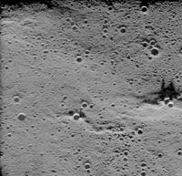
I managed to pull this one out, just to prove I could.
Phil
-------------------- ... because the Solar System ain't gonna map itself.
Also to be found posting similar content on https://mastodon.social/@PhilStooke Maps for download (free PD: https://upload.wikimedia.org/wikipedia/comm...Cartography.pdf NOTE: everything created by me which I post on UMSF is considered to be in the public domain (NOT CC, public domain) |
|
|
|
|
|
|
Sep 28 2010, 04:38 AM
Post
#113
|
|
 Administrator Group: Admin Posts: 5172 Joined: 4-August 05 From: Pasadena, CA, USA, Earth Member No.: 454 |
To be honest, that image doesn't look so great. Does it even improve on Clementine? Do these images have any use beyond their novelty value ("hey, Europe had a lunar orbiter once too")?
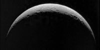
Here's one of those North Pole images from when it was released back in 2004. Neat to see it's part of an longer sequence, and definitely an unusual viewpoint on the Moon. -------------------- My website - My Patreon - @elakdawalla on Twitter - Please support unmannedspaceflight.com by donating here.
|
|
|
|
|
Sep 28 2010, 09:04 AM
Post
#114
|
|
|
Senior Member Group: Members Posts: 3648 Joined: 1-October 05 From: Croatia Member No.: 523 |
AMIE is not exactly the best imager in the world. It appears to be affected by scattered light, is fairly low resolution and uses lossy wavelet compression with varying degrees of compression. Though in all honesty, that image of Phil's looks like it's taken in high sun so only albedo variations are seen (contrast-enhanced?).
-------------------- |
|
|
|
|
Sep 28 2010, 11:20 AM
Post
#115
|
|
|
Solar System Cartographer Group: Members Posts: 10160 Joined: 5-April 05 From: Canada Member No.: 227 |
See my map, higher up the page - the black areas, including the south pole itself, are 50 m/pixel, better than Clementine's UV-VIS images. So some small areas are better. Plus, the polar coverage was much better in time sampling - all seasons at both poles (Clementine operated for only about 3 months).
One unfortunate thing is that there was only a short period during which the SMART-1 images were the best. Now we have them, but most people are more likely to want to use LROC WAC images, or others (Kaguya, and ISRO is said to be releasing its Chandrayaan images by the end of this year) if they can get them. I just chose my image at random, not even noting where it was from. Phil -------------------- ... because the Solar System ain't gonna map itself.
Also to be found posting similar content on https://mastodon.social/@PhilStooke Maps for download (free PD: https://upload.wikimedia.org/wikipedia/comm...Cartography.pdf NOTE: everything created by me which I post on UMSF is considered to be in the public domain (NOT CC, public domain) |
|
|
|
|
Sep 29 2010, 01:48 PM
Post
#116
|
||
|
Solar System Cartographer Group: Members Posts: 10160 Joined: 5-April 05 From: Canada Member No.: 227 |
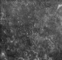
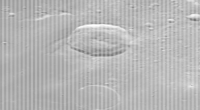
Here's another random image:
A near-terminator shot. Again I didn't check its location. These are 32-bit images, but all the action is in the lower 16 bits, so as a tip for people who want a quick way to browse them: import as a Photoshop raw, using 16 bit IBM format and either 1024 by 548 or 512 by 548 as the size (depending on the file size). That splits each 32 bit pixel into two, making vertical lines down the image, alternating between image and blank. Now use 'image size' and nearest neighbor sampling (will not work otherwise!) to reduce to 512 by 548 or 256 by 548 (depending on file size). Now you have just the image lines left, and a contrast stretch will optimize it for viewing. After a good stretch it can be saved in 8 bit if you prefer, as this has been. Phil -------------------- ... because the Solar System ain't gonna map itself.
Also to be found posting similar content on https://mastodon.social/@PhilStooke Maps for download (free PD: https://upload.wikimedia.org/wikipedia/comm...Cartography.pdf NOTE: everything created by me which I post on UMSF is considered to be in the public domain (NOT CC, public domain) |
|
|
|
|
|
|
Sep 29 2010, 02:33 PM
Post
#117
|
|
|
Senior Member Group: Members Posts: 3648 Joined: 1-October 05 From: Croatia Member No.: 523 |
Phil, that sounds like a rather un-quick way to browse images! Wouldn't a faster method be to just dump an image properly into a PNG?
-------------------- |
|
|
|
|
Sep 29 2010, 05:20 PM
Post
#118
|
|
|
Solar System Cartographer Group: Members Posts: 10160 Joined: 5-April 05 From: Canada Member No.: 227 |
True! Obviously IMG2PNG would be better than the approach I described. I just wanted to offer a method to people who don't have, or don't want to get into, that software.
I doubt if I will ever do very much with these images. Sadly, their time may have passed already. Phil -------------------- ... because the Solar System ain't gonna map itself.
Also to be found posting similar content on https://mastodon.social/@PhilStooke Maps for download (free PD: https://upload.wikimedia.org/wikipedia/comm...Cartography.pdf NOTE: everything created by me which I post on UMSF is considered to be in the public domain (NOT CC, public domain) |
|
|
|
|
Sep 30 2010, 09:03 PM
Post
#119
|
||
|
Newbie Group: Members Posts: 6 Joined: 11-April 09 From: Sweden Member No.: 4726 |
Now I've got a hang on the data set and I manage do create my first cross eye 3d image from the data set.
Dated or not, SMART-1 was built in Sweden and assembled in my home town, Linköping, that's why I'm interested. =) |
|
|
|
|
|
|

|
Lo-Fi Version | Time is now: 13th May 2024 - 09:37 AM |
|
RULES AND GUIDELINES Please read the Forum Rules and Guidelines before posting. IMAGE COPYRIGHT |
OPINIONS AND MODERATION Opinions expressed on UnmannedSpaceflight.com are those of the individual posters and do not necessarily reflect the opinions of UnmannedSpaceflight.com or The Planetary Society. The all-volunteer UnmannedSpaceflight.com moderation team is wholly independent of The Planetary Society. The Planetary Society has no influence over decisions made by the UnmannedSpaceflight.com moderators. |
SUPPORT THE FORUM Unmannedspaceflight.com is funded by the Planetary Society. Please consider supporting our work and many other projects by donating to the Society or becoming a member. |
|