CE-2 flyby of Toutatis |

  |
CE-2 flyby of Toutatis |
 Dec 15 2012, 07:37 AM Dec 15 2012, 07:37 AM
Post
#76
|
|
 Senior Member  Group: Members Posts: 1729 Joined: 3-August 06 From: 43° 35' 53" N 1° 26' 35" E Member No.: 1004 |
wow! China releases the first pics and I happen to be sleeping?!? btw it's good to be proven wrong about the number of them!
Kudos to the Chinese! EDIT: gotta love this! in the west we tend to compare asteroids to potatoes. someone on the 9ifly forum is comparing it... to a ginger root! |
 |
 
|
|
Dec 15 2012, 08:32 AM
Post
#77
|
|
|
Senior Member Group: Members Posts: 1729 Joined: 3-August 06 From: 43° 35' 53" N 1° 26' 35" E Member No.: 1004 |
QUOTE (elakdawalla @ Dec 15 2012, 01:09 AM)  I wonder, were these images taken with the webcam-style cameras they used to monitor deployments and rocket firings? is this schema is to be believed http://english.cri.cn/mmsource/images/2012...8e4073c048f.jpg they were indeed all taken using the webcams (CMOS and not CCD cameras) QUOTE Dec13 15:25 Return solar panels to 180 degrees from 9ifly forum, this seems to mean that the solar panel that the webcam was designed to monitor was rotated out of the camera fov |
|
|
|
|
Dec 15 2012, 09:08 AM
Post
#78
|
|
 Member Group: Members Posts: 276 Joined: 11-December 07 From: Dar es Salaam, Tanzania Member No.: 3978 |
Outstanding Chinese performance. Thanks for posting the images so quickly! Really took my breath away
-------------------- |
|
|
|
|
Dec 15 2012, 09:30 AM
Post
#79
|
|
 Member Group: Members Posts: 106 Joined: 26-September 05 Member No.: 508 |
Here is a 3D PDF of the shape model. (It is heavily optimized to be under the 1MB attachment limit.)
Attached File(s)
|
|
|
|
|
Dec 15 2012, 11:14 AM
Post
#80
|
|||
 Member Group: Members Posts: 796 Joined: 27-February 08 From: Heart of Europe Member No.: 4057 |
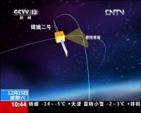
Here is Chinese TV show dedicated to Toutatis flyby and ChangE program.
I recommend you last few minutes (from ~55:00), where you can see some shots from planned ChangE-3 mission. As I understand from these pictures, they tried some imaging around closest flyby distance (~3.2 km) by different camera, so maybe we can expect even better images in future.
Attached thumbnail(s)
-------------------- |
||
|
|
|
||
|
Dec 15 2012, 11:58 AM
Post
#81
|
|
|
Member Group: Members Posts: 293 Joined: 29-August 06 From: Columbia, MD Member No.: 1083 |
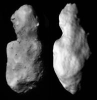
Congrats to the Chinese! There's some depressions that obviously look like craters there, but not as many as I'd expect and they seem "muted". Would this suggest a low-density "rubble pile" composition?
|
|
|
|
|
Dec 15 2012, 11:58 AM
Post
#82
|
|
|
Junior Member Group: Members Posts: 52 Joined: 16-November 06 Member No.: 1364 |
QUOTE (Phil Stooke @ Dec 15 2012, 03:47 AM) If this is an approach sequence, there may be a departure sequence as well. Phil I wonder if this "approach sequence" is in fact a single image shown at different sizes. |
|
|
|
|
Dec 15 2012, 12:41 PM
Post
#83
|
|
|
Member Group: Members Posts: 796 Joined: 27-February 08 From: Heart of Europe Member No.: 4057 |
Yes, all images are almost equal (apart from size), but this is exactly what one can expect, when spacecraft is flying in this kind of trajectory (fast and extremely close flyby). From a greater distance, it looks more like a fall.
-------------------- |
|
|
|
|
Dec 15 2012, 02:07 PM
Post
#84
|
|
|
Member Group: Members Posts: 149 Joined: 18-June 08 Member No.: 4216 |
Amazing stuff!
Apart from the sheer speed of the flyby, I would imagine that Toutatis' extremely long rotation period (~24hr) would contribute to it appearing the same - apart from a change of scale - in all images. Also interesting is the relative absence of craters and the presence of boulders. In this sense, Toutatis seems to be intermediate between larger asteroids (eg Eros) where you have both craters and boulders and Itokawa where craters are virtually absent. |
|
|
|
|
Dec 15 2012, 02:12 PM
Post
#85
|
||
|
Senior Member Group: Members Posts: 1729 Joined: 3-August 06 From: 43° 35' 53" N 1° 26' 35" E Member No.: 1004 |
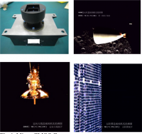
this is what a Chang'e 2 CMOS webcam looks like. and some treat from earlier in the mission
Attached thumbnail(s)
|
|
|
|
|
|
|
Dec 15 2012, 02:31 PM
Post
#86
|
||
|
Solar System Cartographer Group: Members Posts: 10151 Joined: 5-April 05 From: Canada Member No.: 227 |
Comparison of the new image with the radar shape from the paper I linked to above. I think the new image is tilted a bit, with the top end tilted perhaps 20 degrees toward the camera.
Phil
-------------------- ... because the Solar System ain't gonna map itself.
Also to be found posting similar content on https://mastodon.social/@PhilStooke Maps for download (free PD: https://upload.wikimedia.org/wikipedia/comm...Cartography.pdf NOTE: everything created by me which I post on UMSF is considered to be in the public domain (NOT CC, public domain) |
|
|
|
|
|
|
Dec 16 2012, 09:53 AM
Post
#87
|
|
|
Senior Member Group: Members Posts: 1729 Joined: 3-August 06 From: 43° 35' 53" N 1° 26' 35" E Member No.: 1004 |
Chinese sources such as this http://www.stdaily.com/stdaily/content/201...tent_552959.htm acknowledge that the CMOS monitoring webcam has been used. the 200 g, 1024 x 1024 pixel camera apparently shot 5 pictures every second for more than 100 seconds around closest approach. The camera has a 7.2 degree fov.
I wonder whether any science camera picture was finally taken or not. from the timeline on the left of this picture http://i.dailymail.co.uk/i/pix/2012/12/15/...269_634x422.jpg which yaohua2000 translated here http://www.unmannedspaceflight.com/index.p...st&p=195772 I think it was not even powered on. Chinese sources also report that a domestic telescopic observation and orbit determination effort was carried out on Toutatis. This was not strictly needed for such a well known object, but was still an useful exercise for an encounter with a more obscure object. |
|
|
|
|
Dec 16 2012, 10:15 AM
Post
#88
|
|
|
Member Group: Members Posts: 796 Joined: 27-February 08 From: Heart of Europe Member No.: 4057 |
I have somewhat different informations about ChangE-2 cameras.
According to this abstract, CE-2 has four monitoring cameras (+ fifth camera - scientific stereo camera). Three cameras are designed to provide engineering monitoring of spacecraft (solar panel, engine, antenna) and one camera is used for moon imaging. Moon imaging camera weights 502 g and has CMOS chip 1280×1024. Engineering cameras weights 352 g. -------------------- |
|
|
|
|
Dec 16 2012, 11:30 AM
Post
#89
|
|
|
Junior Member Group: Members Posts: 64 Joined: 15-June 12 From: Hong Kong Member No.: 6419 |
Apparently the main camera was not powered on (nor it seems the other instruments on the spacecraft either), due to these reasons:
1. The data transfer from the main CCD camera would be very bad at such a long distance from Earth 2. The double linear-phase CCD camera has such a small FOV that it would not be able to take photos at such a relative speed during the fly-by I might need to dig around the 1 hour special report on the Chinese news TV channel yesterday to look for other interesting facts on the fly-by..... Oh and forget about another mission by CE-2, it has less than 10 m/s of delta-v capacity left.... -------------------- UMSF - the place of Opportunity to satisfy your Spirit of Curiosity via Perseverance
|
|
|
|
|
Dec 16 2012, 12:01 PM
Post
#90
|
|
|
Senior Member Group: Members Posts: 1729 Joined: 3-August 06 From: 43° 35' 53" N 1° 26' 35" E Member No.: 1004 |
I don't want to belittle the CE-2 achievement, but I have a question for the scientific data minded: beside basic shape and topography, what can be extracted from this kind of webcam-like, probably uncalibrated images? not much I suspect.
as for another extended mission, I think even merely tracking the probe as long as possible, without firing the engine anymore would provide useful experience for future missions beyond the Moon |
|
|
|
|

|
Lo-Fi Version | Time is now: 25th April 2024 - 10:48 AM |
|
RULES AND GUIDELINES Please read the Forum Rules and Guidelines before posting. IMAGE COPYRIGHT |
OPINIONS AND MODERATION Opinions expressed on UnmannedSpaceflight.com are those of the individual posters and do not necessarily reflect the opinions of UnmannedSpaceflight.com or The Planetary Society. The all-volunteer UnmannedSpaceflight.com moderation team is wholly independent of The Planetary Society. The Planetary Society has no influence over decisions made by the UnmannedSpaceflight.com moderators. |
SUPPORT THE FORUM Unmannedspaceflight.com is funded by the Planetary Society. Please consider supporting our work and many other projects by donating to the Society or becoming a member. |
|