Along the base of Vera Rubin Ridge, (Sites 64-65, Sols 1726-1812, Jun 14-Sep 11 2017) |

  |
Along the base of Vera Rubin Ridge, (Sites 64-65, Sols 1726-1812, Jun 14-Sep 11 2017) |
 Aug 15 2017, 01:25 PM Aug 15 2017, 01:25 PM
Post
#136
|
||
 Senior Member  Group: Members Posts: 2425 Joined: 30-January 13 From: Penang, Malaysia. Member No.: 6853 |
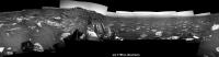
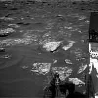
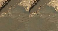
The best I could pull out of MS ICE. L-NavCam 1786. Midnight Planets reports the point to point drive as ~16.0m NE (39º)
|
|
 |
 
|
|
|
Aug 15 2017, 02:19 PM
Post
#137
|
||
|
Senior Member Group: Members Posts: 2817 Joined: 22-April 05 From: Ridderkerk, Netherlands Member No.: 353 |
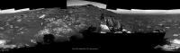
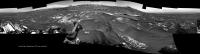
The Navcam L view on Sol 1785.
Jan van Driel
|
|
|
|
|
|
|
Aug 15 2017, 04:54 PM
Post
#138
|
||
|
Senior Member Group: Members Posts: 2817 Joined: 22-April 05 From: Ridderkerk, Netherlands Member No.: 353 |
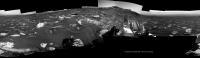
and the view on Sol 1786.
Jan van Driel
|
|
|
|
|
|
|
Aug 15 2017, 06:37 PM
Post
#139
|
||
|
Solar System Cartographer Group: Members Posts: 10146 Joined: 5-April 05 From: Canada Member No.: 227 |
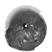
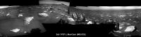
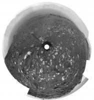
Thanks, Jan and Paul. This is Jan's panorama in circular form. The drive probably terminated as the wheels were negotiating a rocky mound here. It's actually very surprising that this doesn't happen more often!
Phil
-------------------- ... because the Solar System ain't gonna map itself.
Also to be found posting similar content on https://mastodon.social/@PhilStooke NOTE: everything created by me which I post on UMSF is considered to be in the public domain (NOT CC, public domain) |
|
|
|
|
|
|
Aug 15 2017, 07:13 PM
Post
#140
|
|
|
Member Group: Admin Posts: 976 Joined: 29-September 06 From: Pasadena, CA - USA Member No.: 1200 |
QUOTE (Phil Stooke @ Aug 15 2017, 11:37 AM)  ... It's actually very surprising that this doesn't happen more often! We try to avoid these things. Whenever the surface topography is this extreme, the reconstructed surface has "holes" due to occlusions which prevents us from accurately simulating attitude and suspension values during a drive. Sometimes we have no choice, we have to drive through holes (holy drives?) and we spend considerable amount of time to decide which holes to visit. End of drive positions are chosen also to maximize visibility and reduce occlusions in the intended drive direction. Paolo -------------------- Disclaimer: all opinions, ideas and information included here are my own,and should not be intended to represent opinion or policy of my employer.
|
|
|
|
|
Aug 16 2017, 10:10 AM
Post
#141
|
||
|
Senior Member Group: Members Posts: 2425 Joined: 30-January 13 From: Penang, Malaysia. Member No.: 6853 |
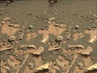
QUOTE (RoverDriver @ Aug 16 2017, 03:13 AM) We try to avoid these things.... Paolo Thanks for the insight Paolo, much appreciated  Looks like they captured the culprit in this sol 1787 mid-drive NavCam image looking back to where yestersols drive halted. Appears to be a loose block that was moved by the rover's wheels.
|
|
|
|
|
|
|
Aug 16 2017, 10:35 AM
Post
#142
|
||
|
Senior Member Group: Members Posts: 2425 Joined: 30-January 13 From: Penang, Malaysia. Member No.: 6853 |
The roughly assembled L-NavCam partial pan using MS ICE that may help pinpoint the location until the full version is posted here. As usual, feel free to delete this post once full pan is posted.
|
|
|
|
|
|
|
Aug 16 2017, 04:48 PM
Post
#143
|
|
|
Member Group: Admin Posts: 976 Joined: 29-September 06 From: Pasadena, CA - USA Member No.: 1200 |
QUOTE (PaulH51 @ Aug 16 2017, 02:10 AM) ... Looks like they captured the culprit in this sol 1787 mid-drive NavCam image looking back to where yestersols drive halted. Appears to be a loose block that was moved by the rover's wheels. ... What happened is that the newly developed traction control software interpreted the local topography as a "wheelie" (*) and tried to correct it but failed to do so. While the available torque is Bugatti-Veyron class (really!), it still cannot change Mars topography. Paolo (*) wheelies on Mars happen when either the mid or rear wheels are raised from the surface due to difference in traction. While driving forwards, if the rear wheel has more traction than the front, the mid wheel can be raised. Vice-versa, while driving backwards if the front wheels have more traction that the mid, the rear wheels can come up. Keeping all wheels on the surface increases overall traction and reduces stress on the wheels and rover planners. -------------------- Disclaimer: all opinions, ideas and information included here are my own,and should not be intended to represent opinion or policy of my employer.
|
|
|
|
|
Aug 16 2017, 07:24 PM
Post
#144
|
||
|
Senior Member Group: Members Posts: 2817 Joined: 22-April 05 From: Ridderkerk, Netherlands Member No.: 353 |
The Navcam L view on Sol 1787.
Jan van Driel
|
|
|
|
|
|
|
Aug 17 2017, 06:53 PM
Post
#145
|
||
|
Senior Member Group: Members Posts: 2817 Joined: 22-April 05 From: Ridderkerk, Netherlands Member No.: 353 |
The Navcam L view on Sol 1788.
Jan van Driel
|
|
|
|
|
|
|
Aug 17 2017, 10:41 PM
Post
#146
|
|
|
Member Group: Members Posts: 866 Joined: 15-March 05 From: Santa Cruz, CA Member No.: 196 |
|
|
|
|
|
Aug 20 2017, 12:03 PM
Post
#147
|
||
|
Senior Member Group: Members Posts: 2425 Joined: 30-January 13 From: Penang, Malaysia. Member No.: 6853 |
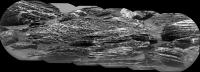
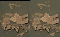
Partial RMI mosaic (sharpened) of VRR, acquired on sol 1790.
Sadly one of the images in the sequence had data drop out, so MS ICE could not be convinced to assemble all of the available images. Even though incomplete, it gives us a fairly good look at the stratigraphy of this section of the ridge... If they resend the errant frame I'll try to assemble the complete mosaic.
|
|
|
|
|
|
|
Aug 21 2017, 06:11 PM
Post
#148
|
||
|
Solar System Cartographer Group: Members Posts: 10146 Joined: 5-April 05 From: Canada Member No.: 227 |
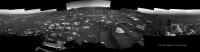
Jan's panorama for sol 1788 in circular form.
Phil
-------------------- ... because the Solar System ain't gonna map itself.
Also to be found posting similar content on https://mastodon.social/@PhilStooke NOTE: everything created by me which I post on UMSF is considered to be in the public domain (NOT CC, public domain) |
|
|
|
|
|
|
Aug 21 2017, 08:39 PM
Post
#149
|
||
|
Senior Member Group: Members Posts: 2817 Joined: 22-April 05 From: Ridderkerk, Netherlands Member No.: 353 |
The Navcam L view on Sol 1792.
Jan van Driel
|
|
|
|
|
|
|
Aug 21 2017, 09:13 PM
Post
#150
|
|
|
Member Group: Members Posts: 866 Joined: 15-March 05 From: Santa Cruz, CA Member No.: 196 |
|
|
|
|
|

|
Lo-Fi Version | Time is now: 20th April 2024 - 03:40 AM |
|
RULES AND GUIDELINES Please read the Forum Rules and Guidelines before posting. IMAGE COPYRIGHT |
OPINIONS AND MODERATION Opinions expressed on UnmannedSpaceflight.com are those of the individual posters and do not necessarily reflect the opinions of UnmannedSpaceflight.com or The Planetary Society. The all-volunteer UnmannedSpaceflight.com moderation team is wholly independent of The Planetary Society. The Planetary Society has no influence over decisions made by the UnmannedSpaceflight.com moderators. |
SUPPORT THE FORUM Unmannedspaceflight.com is funded by the Planetary Society. Please consider supporting our work and many other projects by donating to the Society or becoming a member. |
|