Along the base of Vera Rubin Ridge, (Sites 64-65, Sols 1726-1812, Jun 14-Sep 11 2017) |

  |
Along the base of Vera Rubin Ridge, (Sites 64-65, Sols 1726-1812, Jun 14-Sep 11 2017) |
 Jul 16 2017, 08:31 PM Jul 16 2017, 08:31 PM
Post
#106
|
|
 Member  Group: Members Posts: 809 Joined: 3-June 04 From: Brittany, France Member No.: 79 |
MC34 panorama taken on sol 1756 at 13h32 local time:
 This panorama offers a new perspective on the top right outcrop already imaged on sol 1745 by MC100: 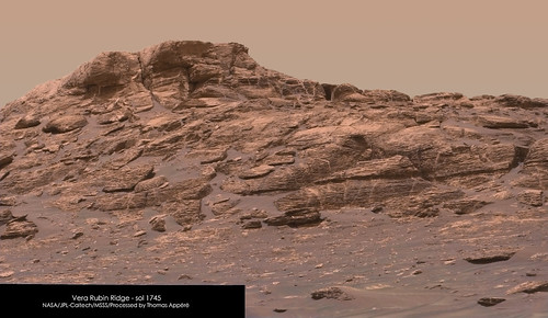
-------------------- |
 |
 
|
|
Jul 17 2017, 01:35 AM
Post
#107
|
|
|
Senior Member Group: Members Posts: 1043 Joined: 17-February 09 Member No.: 4605 |
It is worthy of note that during question time following the public talk on Curiosity, James Erickson was extremely upbeat over the future use of the drill and was extremely confident that a fix to the current problem was imminent. This is good news indeed.
|
|
|
|
|
Jul 18 2017, 01:12 AM
Post
#108
|
||
 Senior Member Group: Members Posts: 2425 Joined: 30-January 13 From: Penang, Malaysia. Member No.: 6853 |
QUOTE (serpens @ Jul 17 2017, 09:35 AM)  It is worthy of note that during question time following the public talk on Curiosity, James Erickson was extremely upbeat over the future use of the drill and was extremely confident that a fix to the current problem was imminent. This is good news indeed. Possible evidence in support of that confidence in this L-MastCam from sol 1757 where we can see they have extended the drill feed mechanism. Emily Lakdawalla referred to "less standard uses of the drill" in her last Curiosity Blog post Maybe leaving the drill extended to drill a hole without the supports, and then obtaining the powdered rock sample with the scoop... difficult on a windy day, but it could keep SAM working 
|
|
|
|
|
|
|
Jul 19 2017, 12:08 AM
Post
#109
|
|
|
Senior Member Group: Members Posts: 1043 Joined: 17-February 09 Member No.: 4605 |
Using the drill even in rotary mode without using the contact sensors and stabilisers would seem to be pretty risky. The percussive action of the drill was designed to pulverise the rock to powder and the vibration, combined with the auguring action of the drill raised the powder to the collection chamber without clogging. I wonder whether rotary action alone would grind rock finely enough to transfer it up the drill shaft to the collection chamber? Given the small size of a drill hole and spoil it is hard to see how the scoop could secure a sample and even then there would be a high probability of cross contamination from surface dust. Still, the work arounds that have been achieved on MER and MSL have been impressive to say the least and it will be fascinating to see what magic they use with the drill.
|
|
|
|
|
Jul 19 2017, 01:31 AM
Post
#110
|
|
|
Founder Group: Chairman Posts: 14431 Joined: 8-February 04 Member No.: 1 |
Percussive drilling was pretty much off the table before the current drill issues arose - so that's not really a consideration. Rotary only drilling was planned when the problem with the feed first arose (and that was my 7th training shift on ECam - Sol 1536
I've not seen specifics of the drill testing they've been doing with the test-bed - but I've heard good things about their results. The fact that we're now 7.5 months after the drill anomaly occurred and only just beginning to see work arounds being discussed for use on Mars should give you some idea of how much care, diligence and attention is being paid to this. Depending on your value of 'risky' - I wouldn't say they were planning anything that puts the vehicle or other functional instruments at 'risk'. (see this old press release - https://mars.jpl.nasa.gov/news/curiosity-ro...-hiatus&s=2 ) |
|
|
|
|
Jul 21 2017, 03:33 PM
Post
#111
|
||
 Senior Member Group: Members Posts: 4246 Joined: 17-January 05 Member No.: 152 |
Clouds drifting by on 1758, unstretched:
|
|
|
|
|
|
|
Jul 21 2017, 03:36 PM
Post
#112
|
||
|
Senior Member Group: Members Posts: 4246 Joined: 17-January 05 Member No.: 152 |
Another navcam sequence on the same sol which needed some stretching (after subtraction of the mean):
|
|
|
|
|
|
|
Jul 29 2017, 12:35 AM
Post
#113
|
|
|
Senior Member Group: Members Posts: 1043 Joined: 17-February 09 Member No.: 4605 |
Looking at relative elevations, would I be correct in thinking that the erosion resistant, hematite cemented Vera Rubin Ridge cap would have been part of the horizon between the Murray Formation and the sulphate unit?
|
|
|
|
|
Jul 29 2017, 11:34 PM
Post
#114
|
|
|
Senior Member Group: Members Posts: 2346 Joined: 7-December 12 Member No.: 6780 |
Do you suggest, that the clay unit is part of the Murray Formation? Then, after the clay unit, there should be another fragment of Vera Rubin Ridge type, before the sulfate unit begins.
|
|
|
|
|
Jul 30 2017, 12:37 AM
Post
#115
|
|
|
Senior Member Group: Members Posts: 1043 Joined: 17-February 09 Member No.: 4605 |
If Mr Steno's principle of original continuity holds true then the (pre-erosion) upper level of what became the hematite ridge would have been a continuous, pretty much horizontal sheet that was then covered by the sulphate unit. The clay is in an eroded trough and since there does not seem any indication of the layer on Curiosity's side of the ridge the clay may have formed as a late, localised event during the erosion of Mount Sharp, possibly connected with the fan. If the ridge upper level was part of the horizon between Murray formation and the sulphate unit then the hematite would have probably formed within reasonably unconsolidated, layered sediment which makes the concept of a linear confined aquifer near the surface, oxygenated via the vadose zone less likely than a surface stream. The transition to a more acid environment represented by the sulphates does raise a few possibilities with respect to the ferric deposition process.
|
|
|
|
|
Jul 31 2017, 12:13 AM
Post
#116
|
|
|
Senior Member Group: Members Posts: 2346 Joined: 7-December 12 Member No.: 6780 |
Wouldn't the finely laminated structure of Vera Rubin Ridge, as far as we can see thus far, suggest, that we are still in a lacustrine environment, but closer to the surface below an oxygen-bearing atmosphere?
The sufate layer may have formed after erosion of lithified older layers. -- I'm not perfectly up to date with the current state of discussion about the contact to the sulfate layer, but I'd presume, there are still various options. |
|
|
|
|
Jul 31 2017, 04:06 AM
Post
#117
|
|
|
Solar System Cartographer Group: Members Posts: 10146 Joined: 5-April 05 From: Canada Member No.: 227 |
I don't think lacustrine, there is lots of cross-bedding in the ridge (see the ridge images at the top of this page), so aeolian accumulation followed by episodes of wetting and lithification would be my guess.
Phil -------------------- ... because the Solar System ain't gonna map itself.
Also to be found posting similar content on https://mastodon.social/@PhilStooke NOTE: everything created by me which I post on UMSF is considered to be in the public domain (NOT CC, public domain) |
|
|
|
|
Jul 31 2017, 04:39 AM
Post
#118
|
|
|
Senior Member Group: Members Posts: 1043 Joined: 17-February 09 Member No.: 4605 |
To be fair we need to get up close to determine whether there is cross bedding indicative of surface water flow or as Phil posits, purely aeolian with later diagenisis. But the presence of the hematite ridge is fascinating.
The thing is that iron oxides have a large number of polymorphs and (for me anyway) confusing phase transformations. However the basic route to hematite requires a ferrous solution (and ferric in solution in low <5 pH waters) and oxidation. We do not know the makeup or partial pressures of the Martian atmosphere at the time the ridge formed but it would be safe to assume that the capacity for oxygenation was very limited. The amount of oxygen required to transition ferrous to ferric and hence deposition as iron hydroxide 2Fe(OH)3 reduces dramatically as pH falls which draws attention to the sulphate unit. The process from the iron hydroxide via goethite to hematite or even direct to hematite is more intuitive with standard notation where 2Fe(OH)3 = Fe2O3·3H2O or Ferric Oxide Trihydrate. The transition from Goethite 2FeO(OH) = Fe2O3·H2O can occur at quite low temperatures (40 celcius) which could have been supplied via burial. |
|
|
|
|
Jul 31 2017, 03:52 PM
Post
#119
|
|
 Member Group: Members Posts: 684 Joined: 24-July 15 Member No.: 7619 |
QUOTE (Phil Stooke @ Jul 31 2017, 04:06 AM) I don't think lacustrine, there is lots of cross-bedding in the ridge (see the ridge images at the top of this page), so aeolian accumulation followed by episodes of wetting and lithification would be my guess. Is there any geomorphology on earth where we have a good understanding of deposition under permafrost conditions, something with aeolian dust, snowdrifts and sand? |
|
|
|
|
Aug 2 2017, 04:41 AM
Post
#120
|
||
|
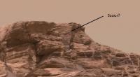
Senior Member Group: Members Posts: 1043 Joined: 17-February 09 Member No.: 4605 |
Just as a follow up to Phil's observation. Probably wishful thinking but this could possibly be scour which would imply running surface water.
Attached thumbnail(s)
|
|
|
|
|
|
|

|
Lo-Fi Version | Time is now: 20th April 2024 - 01:32 AM |
|
RULES AND GUIDELINES Please read the Forum Rules and Guidelines before posting. IMAGE COPYRIGHT |
OPINIONS AND MODERATION Opinions expressed on UnmannedSpaceflight.com are those of the individual posters and do not necessarily reflect the opinions of UnmannedSpaceflight.com or The Planetary Society. The all-volunteer UnmannedSpaceflight.com moderation team is wholly independent of The Planetary Society. The Planetary Society has no influence over decisions made by the UnmannedSpaceflight.com moderators. |
SUPPORT THE FORUM Unmannedspaceflight.com is funded by the Planetary Society. Please consider supporting our work and many other projects by donating to the Society or becoming a member. |
|