Printable Version of Topic
Click here to view this topic in its original format
Unmanned Spaceflight.com _ Opportunity _ The Valley Without Peril (Bay C5)
Posted by: Tesheiner Mar 8 2007, 11:56 AM
Given the interest on this particular bay as a potential entry point and also because we are way past Bahia Blanca (former "current thread") I've opened this thread.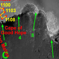
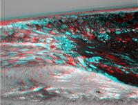
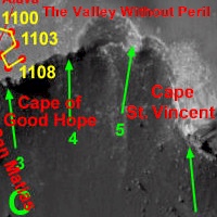
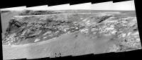
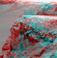
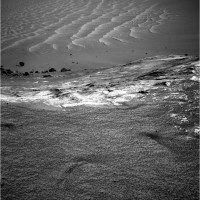
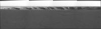
Here is a "quick&dirty" autostitched navcam mosaic taken on sol 1108 focused on such bay and following cape (D1).
|
Edited: We might rename the thread properly once C5 is named.
Posted by: Olenthra Mar 8 2007, 01:43 PM
When you say "Bay C5",
do you mean the bay inbetween the capes "C3 : The Cape of Good Hope" and the unnamed cape "D1"?
"C5" appears to be that small promontory inside this bay.
Olenthra
Posted by: MarsIsImportant Mar 8 2007, 01:57 PM

do you mean the bay inbetween the capes "C3 : The Cape of Good Hope" and the unnamed cape "D1"?
"C5" appears to be that small promontory inside this bay.
Olenthra
I just assumed it was the one I mark here with the blue circle.
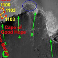
It is the only bay in the image that is possible to navigate down.
Posted by: Olenthra Mar 8 2007, 02:41 PM
It seems to me that when they name their bays, they usually extend from one large promonotory to the next. Like "Duck Bay". It extends from "P4: Cabo Frio" to "A1: Cabo Verde" even though there are some small promonotories in it.
Posted by: Stu Mar 8 2007, 02:43 PM
Said it before, I know, but I love this planet...!

|

Posted by: Tesheiner Mar 8 2007, 04:15 PM
do you mean the bay inbetween the capes "C3 : The Cape of Good Hope" and the unnamed cape "D1"?
"C5" appears to be that small promontory inside this bay.
Olenthra
I would have to search that post, but IIRC when this naming convention was "invented" here it was assumed that the bays would be labelled the same as the next cape clockwise i.e. bay C5 is the one between capes C4 and C5.
I'm so used to look to these pictures that sometimes I forget to remember that we are looking to another planet.
And I say to myself: that's mars, not the earth! And this picture was taken just a few hours ago!
Think of it.
Posted by: Stu Mar 8 2007, 04:24 PM
I think about it all the time Tesh, especially when I'm giving a talk and tell the audience "If you're online you can go to websites and see new pictures from Mars EVERY DAY..." I often find myself pausing to look at the screen myself, stopping in mid-sentence, thinking "There... right there... people will stand on this exact same spot one day and see that exact same view..."
And then you know what I think? I think...
Lucky <clink>s !!!!

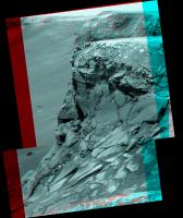
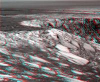
Posted by: fredk Mar 8 2007, 06:13 PM
I'm looking forward to the new bay. I thought there was something remarkable about http://marsrovers.jpl.nasa.gov/gallery/all/1/p/1107/1P226459867EFF8092P2383L2M1.JPG showing a bit of the bay on sol 1107. The upper walls have that look of a "texture" that's been "draped" onto a 3D model - reminiscent of Beagle crater. And the contrast is striking with the dark lower slopes. If you look at the orbital imagery, you can see that this darkness is actually the extension into the crater of one of the dark streaks that stretch out onto the plains.
I had to anaglyph it:
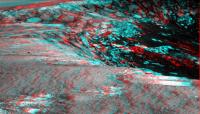
|
Posted by: gallen_53 Mar 8 2007, 07:53 PM
|
|
Me too! I think people should live on Mars (the sooner the better).
I'm really struck by the stratification of the rocks visible in the above image. I'm no geologist but it looks like sandstone. I sure this has been discussed at great lengh. What's the current theory? Was the layering due to some sort of "annual" flooding in this region or were the layers made over eons due to randomly occurring cataclysmic events, e.g. large meteor impacts?
Posted by: fredk Mar 9 2007, 04:35 AM
Another mesmerizing view of the Bay to come:
|
Posted by: Tesheiner Mar 9 2007, 09:15 AM
Does anybody wants to risk a slope angle calculation based on the last pancams?
Posted by: WindyT Mar 9 2007, 08:57 PM
which bay will get the honor?
Posted by: ustrax Mar 9 2007, 09:12 PM
Boys...I think we're going IN...
SSomeone just wrote me the following...:
"You might be interested to know that we have named the next alcove beyond
Cape of Good Hope... it's called the Valley Without Peril. We should see
within the next few sols whether or not it lives up to its name!  "
"

Posted by: Pando Mar 9 2007, 09:15 PM
Updated labels
edit: ustrax beat me to it by 3 minutes! 
Posted by: ustrax Mar 9 2007, 09:28 PM
edit: ustrax beat me to it by 3 minutes!
;-)
That looks nice! :-)
Not definitive but...
"We haven't decided yet. But we're going to decide pretty soon."
EDITED: I remember http://www.unmannedspaceflight.com/index.php?s=&showtopic=3291&view=findpost&p=71508...and I'm drunk again

Posted by: Tesheiner Mar 9 2007, 09:42 PM
Kudos, Ustrax!
Hey Doug (or any mod.), could you please rename this thread?
Something like "The Valley Without Peril (Bay C5), after Cape of Good Hope".
Posted by: Pando Mar 9 2007, 10:58 PM

Hmmm let's see... <looking for a bottle>
Posted by: CosmicRocker Mar 10 2007, 04:48 AM
Congratulations, ustrax, and thanks for sharing that message with us.
In retrospect, you've got to know they were saving that name for just the right bay. The upper parts of The Valley Without Peril that Opportunity has imaged seem have slopes in the 25 degree range. Two questions come to mind: Is this a toe-dip, or a deeper plunge, and what are the targets?
Posted by: MarsIsImportant Mar 10 2007, 07:32 AM
This is getting interesting.
I think the new name refers to the lack of peril because of possible power loss with the tilt. This maybe the first bay that they can navigate a course to minimize power loss. That does not mean they will actually go down this particular bay. The question is whether they want to go down this particular one or wait for a better opportunity closer to the 120 degree mark.
If we think of the previous names of bays and consider power ratios, then they start to make sense. They ducked the first one. Bottomless was a power trap. The bay of Toil needs no explanation. Bahia Blanca means white bay which could refer to the increasing power opportunity. But strangely enough both Bahia Blanca and the Gulfo San Matias refer to winter range locations of the Peregrine Falcon in South America. This could mean that we are not warm enough yet. So Valley Without Peril could easily mean that the power "winter" is over. That doesn't mean that power considerations have suddenly become ideal. It just means that it is within the realm of possibility.
Posted by: Stu Mar 10 2007, 08:39 AM
So... potential targets anyone IF we go Over The Top soon...? Hands up who would like to see some "from below" views of that rocky protrusion over on the right, with its very distinctive and eye-catching dark band at the top...

|
BTW, MarsIsImportant... I love your thinking... at first I thought "That's a conspiracy theory worthy of the Smoking Man standing in shadows in an alley..." but when you think about it, it makes some sense...
Posted by: Stu Mar 10 2007, 10:44 AM
... and in 3D...

|
Posted by: jvandriel Mar 10 2007, 04:01 PM
Here is the view in the drive direction on Sol 1108
Taken with the L2 Pancam.
jvandriel

|
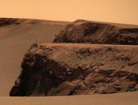
Posted by: Ant103 Mar 10 2007, 05:45 PM
Nice view toward the horizon on Sol 1102 (an other color panorama in previson  ...) :

|
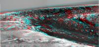
Posted by: fredk Mar 10 2007, 06:08 PM
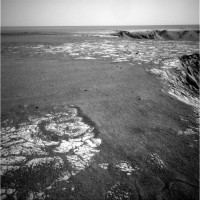
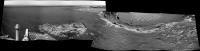
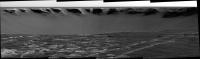
New long baseline views today from sols 1096/97. The first one looks past the tip of the Cape of Good Hope and across the Valley Without Peril. The 3D is pretty extreme here:

|
This one is the adjacent view looking at the series of capes beyond. Without 3D this view was a jumbled mess, but now it all makes sense:

|
Posted by: fredk Mar 10 2007, 06:19 PM
Thanks for that colour view, ant. In that view we're above the Lump - its top is just off to the right. I was wondering if any of the rock on top of Good Hope would show the same colour as the Lump (relatively greenish), and I think I've found a couple of small pieces:

|
Posted by: Tesheiner Mar 10 2007, 10:42 PM
Today was driving sol (1111).
There are a couple of hazcams available (http://qt.exploratorium.edu/mars/opportunity/forward_hazcam/2007-03-10/ and http://qt.exploratorium.edu/mars/opportunity/rear_hazcam/2007-03-10/), not enough to pinpoint the rover's position. However, I think it's possible to see the "lump#2" just to the right of the "mini-cape" C5 on http://qt.exploratorium.edu/mars/opportunity/forward_hazcam/2007-03-10/1F226821647EFF80HCP1212L0M1.JPG and with that assumption I would locate Opportunity around the NE side of the Valley Without Peril.
Edited: Ooops, navcam and pancams are finally available. Time to double-check what I said above.
Edited again: Got it. Navcam (at 144º): http://qt.exploratorium.edu/mars/opportunity/navcam/2007-03-10/1N226822306EFF80HCP0685L0M1.JPG.
Mmm, "without peril"? 
Posted by: MarsIsImportant Mar 10 2007, 11:01 PM
It looks to me that there is a second lip on the Valley without Peril that makes is far too dangerous for ingress. A toe dip would be safe if necessary, because the slope is fairly shallow between the first and second lip of the rim; but the rover is not going down all the way at this particular bay. There is no way. Oppy might as well try one of the cliffs. ...Just my opinion from the new images that just came down.
Posted by: BrianL Mar 11 2007, 06:09 AM
I think perhaps the viewing angle on the latest pancams make it look worse than it is. I don't see such a drop on the 1108 pictures. Let's see what it looks like when Oppy moves up to the edge.
Brian
Posted by: CosmicRocker Mar 11 2007, 06:53 AM
I hate making predictions around here, but yeah, that ledge looks dangerous from the rover's eyes and those of HiRise. But then again, I predicted she'd never crawl out of Endurance. They know what they are doing.
Going out on a ledge of my own making, I think they might want to simply get to a position where they can improve the angular resolution of the pancams and other instruments. That eastern wall is a view to die for.
Posted by: Stu Mar 11 2007, 08:31 AM
Hey ustrax, how's this for an "abyss"...?

|
Posted by: Tesheiner Mar 11 2007, 08:32 AM
RE steepness, I think BrianL is right.
The perception is usually worst from the top then from the side of a slope.
Posted by: fredk Mar 11 2007, 04:26 PM
As you can see from Tesheiner's route map, we're pretty much sitting at the edge of the first of the darkest streaks that radiate out onto the plains. It's not as obvious when we're this close - I've circled it in this sol 1111 navcam:
|
Posted by: ustrax Mar 12 2007, 05:13 PM
Yeap Stu...http://qt.exploratorium.edu/mars/opportunity/pancam/2007-03-10/1P226822888EFF80HCP2388L2M1.JPG, in my oppinion, one of the most exciting views from this mission EVER!
Beautiful and dramatic...
Posted by: BrianL Mar 12 2007, 06:12 PM
Beautiful and dramatic...
Yep, indeed. Can we get a few of Fred's silhouettes in the shot for a sense of scale?
Thanks
Brian
Posted by: mchan Mar 13 2007, 01:58 AM
Valley Without Peril gets title billing in latest Opportunity update --
http://marsrover.nasa.gov/mission/status.html#opportunity
Posted by: Phil Stooke Mar 13 2007, 03:11 AM
To me, the Valley without Peril looks very perilous - anyone can get into a hole, but I don't see Oppo getting out again, and the exposures don't look as accessible either. I say go back to Duck Bay.
Phil
Posted by: WindyT Mar 13 2007, 03:29 AM
I too believe this this bay is probably not the safest ingress (I'm a big fan of looking at the bays closer to the Soup Dragon) but since I also hold a lot of trust for Oppy's drivers and mgmt, I'll just sit here and prepare for the rollercoaster ride down.
Posted by: MarsIsImportant Mar 13 2007, 04:12 AM
I think the name is just a marker. It doesn't mean the MER team will take the rover down this bay. Duck bay might be better than this for safety reason.
Perhaps they see those magnificent cliffs as the target. If they can get there, it would be worth it. But I don't think they can safely get there. If they do try to go in here, the rover is not likely to get out--at least not the same way it went down. I see only one possible track down this particular bay. That track looks to be like a "dead man's curve" of a slope (from the recent pancamss of it). From above, it doesn't look so steep; but it is.
Posted by: Pando Mar 13 2007, 07:23 AM
I think the steepness is an illusion from the pancam due to foreshortening. http://qt.exploratorium.edu/mars/opportunity/navcam/2007-03-10/1N226822306EFF80HCP0685R0M1.JPG looks much better, and once we get closer to the rim to see the full slope it should be manageable.
Posted by: djellison Mar 13 2007, 08:36 AM
The new anims of Victoria crater made from HiRISE DEMS makes Sans-Peril look very interesting - especially when you don't have the really steep, large outcrops each side to hide the sun, and MODY.
Doug
Posted by: Tesheiner Mar 13 2007, 03:49 PM
http://marsrover.nasa.gov/mission/status.html#opportunity
It includes the name of the next Cape, too.
Does it sounds familiar to you, Ustrax?
Posted by: ustrax Mar 13 2007, 04:17 PM
Does it sounds familiar to you, Ustrax?
...http://216.239.59.104/search?q=cache:y1n7uWUXmkgJ:nla.gov.au/nla.cs-ss-jrnl-hv23-043+cape+st.+vincent+magellan&hl=pt-PT&ct=clnk&cd=2&gl=pt...
But it could also be http://www.bootsnall.com/europetravelguides/portugal/may02endworld.shtml...

Posted by: Pando Mar 13 2007, 04:17 PM
http://www.unmannedspaceflight.com/index.php?s=&showtopic=4002&view=findpost&p=85647

Posted by: Pando Mar 13 2007, 04:22 PM
Wow, the similarity is striking!


Posted by: ustrax Mar 13 2007, 05:52 PM
Yes it is... That's quite a special place...
Here you have some more http://pt.wikipedia.org/wiki/Cabo_de_S%C3%A3o_Vicente and http://en.wikipedia.org/wiki/Cabo_de_S%C3%A3o_Vicente.
But I believe that the Martian Cape was named after the South American one...
Posted by: Floyd Mar 14 2007, 02:53 PM
Nice Opportunity Pancam & Navcam images down earily (or late) on at Exploratorium. Evidentally came down in same downlink as Spirit images.
Posted by: djellison Mar 14 2007, 03:29 PM
Might be that Oppy stayed up to do an AM Odyssey pass to double the downlink.
Doug
Posted by: MarsIsImportant Mar 14 2007, 04:53 PM
Cape St. Vincent is too good of a target to pass up. If it is at all possible to get close to it, we should try. If the Valley of Peril (excuse me--Valley Without Peril) won't work, then we need to find another route. My suggested route (in the entry pool) would get the rover close. If we extended it westward just a bit, it could serve as an alternate route that might work. Meanwhile, we still need better cam shots to determine whether this new bay is possible to navigate. If it is, then it would be the shortest route to Cape St. Vincent. It might also allow a good and unique view of the cliffs at St. Mary and other Capes we passed earlier, although not as close.
So despite the apparent danger, it makes sense to investigate a possible route down from here. If they do find a way, then I'll lose the pool. But I won't mind too much, as long as the rover is safe.
Posted by: jvandriel Mar 15 2007, 07:30 PM
The L0 Navcam panoramic view taken on Sol 1111.
jvandriel
|
Posted by: jvandriel Mar 15 2007, 07:45 PM
and the Pancam L2 Panoramic view
taken on Sol 1111.
jvandriel
|
|
Posted by: jvandriel Mar 15 2007, 09:04 PM
and another Panoramic view. This time from Sol 1106.
Taken with the L2 Pancam.
jvandriel
|
Posted by: Astro0 Mar 16 2007, 05:19 AM
Now that's a cool view 
|
Enjoy
Astro0
Posted by: MarsIsImportant Mar 16 2007, 07:28 AM
That's like the very first really good view of the cliffs around St. Mary. Incredible!
I'm amazed at the difference of each part of Victoria. North is very different than the South. The West is very different than the East. And now it turns out that the Western part of Victoria is also very different from the both the Northern and Southern parts.
I hope the rover can either round these capes to the next one or egress so that we can enter again from a different location. I'd like to see Oppy do it 4 or 5 times, at least.
Posted by: fredk Mar 16 2007, 11:45 AM
That's a cool view indeed - those St Mary cliffs really are incredible. Only one slight problem, Astro - left and right channels are switched!
Posted by: fredk Mar 17 2007, 04:12 PM
http://marsrovers.jpl.nasa.gov/gallery/all/opportunity_p1104.html from sol 1104 are down - these are unusual in that they are L4, L5, L6 ("red, green, blue") - is this the "postcard" we heard was planned?
Posted by: Tesheiner Mar 17 2007, 04:18 PM
Exactly.
01104::p2381::10::36::0::0::36::2::74::pancam_good_hope_postcard_L456
Posted by: Stu Mar 17 2007, 04:58 PM
BEAUTIFUL landscape...!!!

|
Posted by: Stu Mar 17 2007, 05:21 PM
Wow.... any rock climbers in the house..?
|
Posted by: Stu Mar 18 2007, 09:48 AM
I know there's a lot of optimism out there, but this does look a bit, um, steep...
|
Posted by: fredk Mar 18 2007, 05:04 PM
Long baseline views of the capes to the west from sols 1106 and 08 now in. This one shows the tip of Cabo Corrientes and a nice 3D look at CSM/beacon and Duck Bay behind:
|
The next view shows Corrientes, and behind that Cape Desire, and behind that Cabo Anonimo, and finally CSM:
|
Warning: 3D effect is pretty extreme over this range of distances!
Posted by: Nirgal Mar 18 2007, 05:57 PM
|
|
Very spectacular indeed ! Lovely with the evening shadows and your beautiful color balance Nirgal
Just browsing quickly through the latest Oppy pics ...
its so good to see all you guys keeping up the great image work !
Looking forward to the coming crater-descent-phase with many new perscpective views
Posted by: jvandriel Mar 18 2007, 08:20 PM
Here is the L4 Panoramic view
taken on Sol 1104.
jvandriel

|
Posted by: jvandriel Mar 18 2007, 10:26 PM
and another view from Sol 1108.
Taken with the L2 Pancam.
jvandriel

|
Posted by: antoniseb Mar 20 2007, 05:32 PM
It's Sol 1121, and no new images have been put on the MER raw images site since 1116. Is this Spring Break at Cornell and/or CalTech? Or is something wrong with Opportunity?
Posted by: Toma B Mar 20 2007, 05:40 PM
Everything is OK with Opportunity...
New images are http://qt.exploratorium.edu/mars/
Posted by: Shaka Mar 20 2007, 06:44 PM
"New images" are timestamped from a week ago. Do the 'codebreakers' have a sense of what's going on at Victoria?
Posted by: atomoid Mar 20 2007, 10:14 PM
the exploratorium site doesnt seem very useful for finding what SOL an image is from, since the timestamps seems to be based on the mod date of the directory or file itself, for instance the latest image date i could find there seems to be from the http://qt.exploratorium.edu/mars/opportunity/pancam/2007-03-20/ which would seem to be a new image.
..however when i punch in the filestamp into the http://mars.lyle.org/ it brings up old images from http://mars.lyle.org/imagery/1P226364888EFF8041P2382L2M1.JPG.html
so wha happen?
well, perhaps it is a new image to us, in that its a backlog from an old sol that hadnt yet been downlinked, but at least that would show oppy is still sending pictures, just not any new ones yet.. so were still in the daark
Posted by: Edward Schmitz Mar 20 2007, 10:32 PM
Opportunity is sending images that were taken on past sol's. But what's going on at VC? Does anyone have any insite into why we're not moving or taking images?
ed
Posted by: Edward Schmitz Mar 20 2007, 10:43 PM
Other than routine science and engineer activities, the last time oppy did anything was drive on sol 1114. There must be something unusual going on.
ed
Posted by: helvick Mar 20 2007, 10:49 PM
According to the http://marsrovers.jpl.nasa.gov/mission/status.html (that would be today):
1114 - Stalled Drive
1115 - No drive
1116 - SSW drive to Cape St Vincent
1117 - No drive
All seems fine for Oppy.
Spirit had a missed day last week due to an MRO safing.
Posted by: alan Mar 21 2007, 05:51 AM
Images from sol 1121 are down. Oppy drove closer to the rim
http://qt.exploratorium.edu/mars/opportunity/rear_hazcam/2007-03-20/1R227704334EFF80K7P1312R0M1.JPG
Posted by: MarsIsImportant Mar 21 2007, 06:24 AM
http://qt.exploratorium.edu/mars/opportunity/rear_hazcam/2007-03-20/1R227704334EFF80K7P1312R0M1.JPG
Nothing has changed my opinion that this is a very dangerous bay to attempt ingress. In fact, the second lip's drop seems even steeper than I thought earlier. The one place that I thought might be possible because of the satellite images appears just as steep as the rest of the second lip. If they attempt, I haven't a clue as to how they will do it.
Posted by: Shaka Mar 21 2007, 06:57 AM
Whoa! Happy feet! http://qt.exploratorium.edu/mars/opportunity/navcam/2007-03-20/1N227702108EFF80JBP1991L0M1.JPG
Posted by: Tesheiner Mar 21 2007, 01:06 PM
Regarding the (lack of) activities on last sols it's curious to find that absolutely NO sequences can be found on the PCDT for sols 1118 up to and including 1120. Perhaps that was due to some diagnosis and/or giving the chance to downlink the data stored on flash memory.
The plan for sol 1122 doesn't include anything more than a few tau measurements but the one for sol 1123 has some sequences related to driving.
PS: I won't be updating the route map this week, because I'm off the town.
Greetings from Germany.
Posted by: fredk Mar 21 2007, 02:17 PM
Posted by: Edward Schmitz Mar 22 2007, 12:01 AM
I don't believe we are even looking down the chute, yet. There will be better views coming shortly...
ed
Posted by: Pando Mar 22 2007, 01:00 AM
Oppy was in a science standdown due to a fault. All is well now.
Posted by: dvandorn Mar 22 2007, 11:41 AM
Well, that was what I was wondering -- especially since I had seen this post from helvick and was truly mystified with his conclusion:
1114 - Stalled Drive
1115 - No drive
1116 - SSW drive to Cape St Vincent
1117 - No drive
All seems fine for Oppy.
A sequence of sols that started with a stalled drive means "all seems fine"? I was thinking that the stalled drive might well have prompted some troubleshooting, of which the sol 1116 drive was a part.
For the most part, I've noticed that science obs tend to get put on hold while they're troubleshooting engineering issues. That's what I thought was happening; nice to see I was right...
-the other Doug
Posted by: fredk Mar 22 2007, 04:06 PM
While we all suffer from withdrawal, we do have a few crumbs to work with, and really they're more like nuggets or jewels than crumbs. Here's sol 1121 pancam looking across the Mouth of Peril:
|
And looking "down the chute" into the "abyss":

|
Posted by: AndyG Mar 23 2007, 08:30 AM
I spy a Hoylette in your second image, FredK. I wonder how often they fall off?
AndyG
Posted by: MarsIsImportant Mar 23 2007, 10:37 AM
AndyG
I spy it too. Yet, it is not just an Hoylette; in fact, it may be more Hoy than "Hoy"--if that's possible. Look at the base underneath; it's practically nonexistent. It's seems to be hanging on almost complete thin air; not just a precariously situated column of rock!
...as far as the question of how often they fall. Not very often.
The rock field below is covered and mixed with fine dust. The primary process that eroded Victoria must have long since slowed to an exceptional crawl, if mass wasting is even still happening at all. I would not want Oppy directly below this feature, just in case it is. If by any chance Oppy could disrupt the base enough by its tracks, then there quickly could be no more rover. But I wonder how much of danger that really would be; perhaps virtually nonexistent.
The following link leads to a page with a flash animation that shows several types of landslide:
http://highered.mcgraw-hill.com/sites/0072402466/student_view0/chapter9/animations_and_movies.html#
The last one seems more applicable here; but, I don't see any water below.
Posted by: MarsIsImportant Mar 23 2007, 10:51 AM
New images are down!
It looks like Oppy is now at the beach.
http://qt.exploratorium.edu/mars/opportunity/pancam/2007-03-23/1P227881169EFF80LOP2390R2M1.JPG
Posted by: antoniseb Mar 23 2007, 11:41 AM
It looks like Oppy is imaging the dark streak from a distance before rolling over to get a personal look.
Posted by: jvandriel Mar 23 2007, 09:49 PM
Here is the panoramic view from Sol 1121.
Taken with the R2 Pancam.
jvandriel

|
Posted by: ngunn Mar 23 2007, 10:20 PM
Wow, that's quite some overhang - that layer must be particularly strong structurally as well as erosion-resistant. I'm wondering if it's the same thing we saw on Cape Desire.
Posted by: imipak Mar 23 2007, 10:51 PM
[...]
And looking "down the chute" into the "abyss":
[...]
Wow, vertiginous views ahoy! Great anaglyphs, thanks fredk
In the absence of occasional seismic shaking caused by impacts or anything else, I would imagine a lot of the hoylet(te)s and other precariously balanced rocks would spend a long time in the zone where a relatively small but close jolt could shake a few loose, whilst being very very slowly eroded by windblown dust and sand.
Posted by: fredk Mar 24 2007, 02:59 PM
Long baseline imagery is in for Cape St. Vincent, looking across the Valley Without Peril on sols 1121 and 1123. Here's the tip, including the "hoylette": (I like the white layer in this view)

|
And the adjoining view, which includes "Lump #2":

|
Posted by: jvandriel Mar 24 2007, 07:39 PM
Opportunity looking at the dark streak
on Sol 1123.
Taken with the L2 Pancam.
jvandriel

|
Posted by: edstrick Mar 25 2007, 09:30 AM
Somebody needs to do a silly-stupid graphic of Oppy with Bathing-Shorts on, before she "takes the plunge".
Posted by: Bobby Mar 26 2007, 04:36 AM
Simple Question:
Why has Oppy's travels become slow??? She was moving quite fast but now she's hardly moving at all. Can someone explain why?
Thanks
Posted by: djellison Mar 26 2007, 09:47 AM
Some stalls, some lost uplinks - it's all in the updates on the JPL site.
Doug
Posted by: Tesheiner Mar 26 2007, 10:54 AM
Those are "old" news.
There was a 30m drive some hours ago placing the rover on the way to Cape St. Vincent (latest map update, http://www.unmannedspaceflight.com/index.php?s=&showtopic=681&view=findpost&p=86842).
This is a gamma-corrected navcam taken from the current site and looking SW back to Duck Bay. We might be near/at a point where Oppy's arrival point @ VC could be visible. Check these two posts http://www.unmannedspaceflight.com/index.php?s=&showtopic=3958&view=findpost&p=84971 and http://www.unmannedspaceflight.com/index.php?s=&showtopic=3958&view=findpost&p=85011.

|
Posted by: antoniseb Mar 26 2007, 12:09 PM
|
|
If this picture was taken at then end of the recent drive, the first dark streak doesn't look very dark close up. I can't convince myself that I even see it.
Posted by: jvandriel Mar 26 2007, 06:44 PM
Victoria Crater on Sol 1126.
Taken with the L0 Navcam.
jvandriel

|
Posted by: Shaka Mar 26 2007, 07:23 PM
It hardly knocks your eye out, but the surface does seem darker right around here than it did farther west. http://qt.exploratorium.edu/mars/opportunity/pancam/2007-03-25/1P228152892EFF80S1P2392L2M1.JPG
Without some MIs of the surface it's going to be hard to tell whether the berries are just more numerous, or have a darker, dirtier (or cleaner) surface.
Above a certain threshold density (and at appropriate sun angles), the spaces between concretions should be mostly in shadows from the berries, so the surface looks dark.
Posted by: atomoid Mar 26 2007, 09:35 PM
Without some MIs of the surface it's going to be hard to tell whether the berries are just more numerous, or have a darker, dirtier (or cleaner) surface.
Above a certain threshold density (and at appropriate sun angles), the spaces between concretions should be mostly in shadows from the berries, so the surface looks dark.
yeah, 'shadow-hiding' (becomes a major problem when mountain biking at night over technical terrain and using a headlamp, but i digress)... it looks as if there was some sort of semi-closeup study done on http://mars.lyle.org/imagery/1P227966154ESF80LOP2587R2M1.JPG.html but i cant find SOL 1124 location on Tesheiner's map so hopefully its in the right place for this question and will have captured some useful info, although no MIs have yet been uplinked. im wondering if the MER team has already figured out our question long ago as something not worth mentioning and isnt bothering to look. but no fear the next cape over has an even darker streak than this one..
Personally, i never could make sense of the dust-removal hypothesis for the formation of these dark streaks, to me it seems like dark dust that is picked up from the turbulence inside VC from eroding the cliff walls and is deposited in this pattern outside the crater as the air slows down and the darker dust falls out of it. but then again, i was a devout 'far-sider' so my track record isnt spotless..
Posted by: Shaka Mar 26 2007, 11:39 PM
Right, the sol 1124 pans are the best we have so far, but they're just not close enough for me to discern whether the berries are shiny (Clean Streaker) or dusty (Dirty Streaker). If there is a coating of dark dust over this area, then we are going to have to identify the material, and its source down in the crater. As of now, I certainly haven't done that, and so I still lean toward the cleaning wind-plume hypothesis. Maybe the next good panorama of Bay without Peril will show something, but I'm not holding my breath.
Posted by: Tesheiner Mar 27 2007, 08:05 AM
Same as for sol 1123. Oppy was stopped at that place from sols 1123 (p.m.) up to 1126 (a.m.).
BTW, tosol (1127) was driving day too. The images should be down soon.
Posted by: Tesheiner Mar 27 2007, 09:44 AM
Here are the images (http://nasa.exploratorium.edu/mars/opportunity/navcam/2007-03-27/) but the rover's position has barely changed.
There was a "turn in place" to place Oppy at the proper heading but followed by less then one meter drive (check this rhaz image: http://nasa.exploratorium.edu/mars/opportunity/rear_hazcam/2007-03-27/1R228234423EFF8100P1312L0M1.JPG).
I would call it an aborted drive.
Posted by: Tesheiner Mar 28 2007, 03:41 PM
Sol 1129 (tonight @ Europe) is planned as another driving day.
The imaging plan includes a 7 shot navcam mosaic tilted down at 30º. IMO they would only do that IF attempting to drive right to the rim to take a shot of the slope.
01129::p1964::navcam_7x1_az162_elminus30_3_bpp
01129::p1965::navcam_3x1_az_342_1_bpp

|
Posted by: WindyT Mar 28 2007, 06:29 PM
Is there a current guess as to the initial slope?
Posted by: fredk Mar 28 2007, 07:04 PM
We measured some slopes on the far side bays to be in the 16 - 20 degree range as I recall. My guess would be similar sorts of values for this bay.
Posted by: Shaka Mar 28 2007, 07:54 PM
I hope you're right, Tesh! Then the 162 Navs should show us whether there's an 'exposed coal seam' (
) down there, and the 342 Navs should show if the valley slopes are "without peril" or not.
Posted by: fredk Mar 29 2007, 03:54 AM
Some details on the sol 1116 fault in the http://marsrovers.jpl.nasa.gov/mission/status_opportunityAll.html#sol1118
On Sols 1117 and 1118 were spent recovering the rover from the fault. Opportunity spent sols 1119 and 1120 resting since these sols fell on an Earth weekend (the project no longer has the resources to bring in a weekend sequencing team).
Posted by: Shaka Mar 29 2007, 04:40 AM
Aha! The penny drops:
After a wild weekend in Pasadena, it comes as no great surprise (especially if Emily was buying the drinks) that Oppy needed a couple of days to sleep it off. No problemo!
We know how it is.
Posted by: CosmicRocker Mar 29 2007, 04:49 AM
They deserve a day (or three) of rest. It appears that we'll need to be patient, waiting for that elminus view and the pancam foreground set.
Posted by: ustrax Mar 29 2007, 09:31 AM
Is there anybosdy http://qt.exploratorium.edu/mars/opportunity/navcam/2007-03-29/1N228143063EFF80LOP1681R0M1.JPG?...
Posted by: Tesheiner Mar 29 2007, 09:44 AM
That image is an old one.
The new ones has a site/drive id "8153".
Watch your step little rover!!!
http://nasa.exploratorium.edu/mars/opportunity/navcam/2007-03-29/1N228414352EFF8153P1964L0M1.JPG http://nasa.exploratorium.edu/mars/opportunity/navcam/2007-03-29/1N228414403EFF8153P1964L0M1.JPG http://nasa.exploratorium.edu/mars/opportunity/navcam/2007-03-29/1N228414455EFF8153P1964L0M1.JPG
Posted by: Tesheiner Mar 29 2007, 09:54 AM
A quick autostitched mosaic...
|
Posted by: ustrax Mar 29 2007, 10:06 AM
That is REALLY scary!
...and thanks for the correction Tesheiner...
Posted by: Floyd Mar 29 2007, 12:35 PM
The entry point would not be in bay D1 in your mosaic, but in C5 where there is a nice http://qt.exploratorium.edu/mars/opportunity/navcam/2007-03-29/1N228414648EFF8153P1964L0M1.JPG.
Hope they move southwest to the tip of cape C5 (I guess unnamed as it is between CGH and CSV) to get second set of images. I would assume that the name "Valley Without Peril" refers only to bay C5 and not D1.
Posted by: Tesheiner Mar 29 2007, 12:56 PM
No doubt. I think D1 was never considered as a possible entry point.
I think too that a move SW is a good one. Half of the bay (C5) is currently hidden behind the tip and if they are still considering it as a possible entry point it would be good to see the whole path down from this side.
> I would assume that the name "Valley Without Peril" refers only to bay C5 and not D1.
I would consider it as a valley with two entrances, "without" and "with" peril.
Edited: Added this two-frame mosaic of Bay C5.
|
Posted by: fredk Mar 29 2007, 03:03 PM
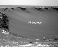
The new images allow us to put some actual constraints on the slopes. From the pre-drive sol 1126 navcam, we can say that the upper reaches of the C5 side of VwP is at around 15 degrees. Totally doable.
|
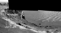
From the 1129 navcam, it's harder to say because we don't have the horizon in the downslope images, but a rough guess, based on Tesheiner's mosaic (did you use 75% reduction?) is 22.5 degrees for the visible portion of the D1 side:
|
There are small errors in these estimates due to navcam distortions and any non-zero elevation of the apparent horizon.
Edit: correcting for actual reduction of 70% (see below) gives 24 degrees for D1.
Posted by: Edward Schmitz Mar 29 2007, 04:20 PM
There would appear to be dark material on the exposed rock in front of the rover. pursumably streak material that has blown out of the crater...
ed
Posted by: Tesheiner Mar 29 2007, 04:25 PM
> From the 1129 navcam, it's harder to say because we don't have the horizon in the downslope images
The "normal" navcams (including the horizon) are tilted down at 17º while the downlooking ones are tilted at 30º. This might be helpful.
> (did you use 75% reduction?)
70%
Posted by: fredk Mar 29 2007, 05:23 PM
Yeah, that certainly is helpful! 70% instead of 75% reduction means my estimate of the D1 side slope increases to 22.5 degrees * 75/70 = 24.1 degrees.
Taking the centre of the downslope D1 navcam to be -30 degrees elevation, I get a slope of 23.9 degrees.
Of course, those decimal points are meaningless, but two distinct methods now give very close to 24 degrees for D1, so I'd be willing to bet that's very close to the truth.
Posted by: imipak Mar 29 2007, 08:21 PM
A few things puzzling my weary brain....
- the dark clear/dusty streak is very clear up ahead - the one we've just passed over (Sols 1123-1126) was virtually invisible at this angle, wasn't it? What's different here?
- I'm also puzzled about those patches of bare rock... eg: http://nasa.exploratorium.edu/mars/opportunity/navcam/2007-03-29/1N228414352EFF8153P1964L0M1.JPG
why a bare patch here, and not just ---> over there? Happenstance and randomness? - 25° is within Oppy's 30° slope capability, but I guess that figure is only true for the path straight down the middle of the 'chute'. The angle appears to increase gradually towards the edges (here at least, unlike the more ramp-like ramps.) So if the object is to get up close to the outcrops, this probably isn't the best entry site.
Posted by: atomoid Mar 29 2007, 09:19 PM
BAD QUOTING REMOVED - STOP IT - Doug
the first streak, which loosk in the http://www.unmannedspaceflight.com/index.php?act=Attach&type=post&id=9894 to be somewhat dark, was never quite as dark as the further one.
And if you go back to the http://mars.lyle.org/imagery/1N227881117EFF80LOP0625R0M1.JPG.html
and then further back to the http://mars.lyle.org/imagery/1P225664044EFF790EP2377L2M1.JPG.html
the first streak is relatively unnoticeable from the ground, a mere hint, but the second streak has always had very sharp and dark features. its odd why there is such a disparity from the ground vs the overhead views of the darkness of the first streak, maybe its just at the brightness threshold where it becomes an artifact of camera exposure contrast stretching/compression, but im hoping well get a MI view of the dark streak so we can settle once and for all whos camping out in ground truth: the dust-covered vs dust-cleaned campers.
Posted by: fredk Mar 29 2007, 10:25 PM
If you look at the MRO orbital imagery, the first dark streak (the one we're sitting on now) is distinctly less dark and has quite a bit fuzzier boundaries than the second streak. Add to that the fact that these are pretty wide features, so you'd expect them to be less noticable when you're sitting on top of them.
If we had a calibrated full 360 navcam mosaic from here I'm sure the streak would be easily noticable.
Posted by: Tesheiner Mar 30 2007, 09:58 AM
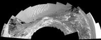
Check these fresh images from sol 1130:
http://nasa.exploratorium.edu/mars/opportunity/navcam/2007-03-30/
Edited: Added a 6x1 navcam mosaic.
|
|
Posted by: ustrax Mar 30 2007, 10:33 AM
Oba Tesheiner!
That looks great!
There's a path inside the crater, to the left, where Oppy could study the intermediate layers, angle allowing...
Posted by: Tesheiner Mar 30 2007, 11:04 AM
"Dear Santa,
Sorry for this late letter, but I have another wish for you.
Could you please tell those guys at JPL that *THIS* is a fantastic place to stop and take a full-color 360º panorama?"
Posted by: Floyd Mar 30 2007, 12:10 PM
Maybe Tesheiner, but I guess Opportunity will go from here to the tip of Cape St. Vincent for the full color 360 panorama. The images from CSV will complete documenting the Valley Without Peril--then Oppy will drive back and enter Victoria about sol 1145.
Posted by: sattrackpro Mar 30 2007, 01:11 PM
http://nasa.exploratorium.edu/mars/opportunity/navcam/2007-03-30/
Edited: Added a 6x1 navcam mosaic.
|
|
YIKES! The rover is close to the edge...
They took more risk than I expected, and the rover said, 'Hey, no big deal - I can do it! That's quite a neat pan, Tesh! Thanks much...
Posted by: lyford Mar 30 2007, 03:54 PM
Why do I imagine something like http://www.mwscomp.com/movies/grail/grail-11.htmhappening?
MER:I don't think I was.
JPL:Yes, you were. You were in terrible peril.
MER: Look, let me go back in there and face the peril.
JPL:No, it's too perilous.
MER:Look, it's my duty... to sample as much peril as I can.
Posted by: Edward Schmitz Mar 30 2007, 04:05 PM
[*]the dark clear/dusty streak is very clear up ahead - the one we've just passed over (Sols 1123-1126) was virtually invisible at this angle, wasn't it? What's different here?
When the rover is far away from the streak, the ground goes from light to dark to light in just a degree or two. This makes for a high contrast image. When it is on top of the streak, the same contrast values are spread out over several frames of the navcam. The much more gradual transition gets lost in all the noise of the image. The noise includes actual camera noise, edge darkening in the navcam, and features in the image.
As fredk said, if we had a fully cal'd 360 mosaic, you would see the streak. But it would never be as obvious as it is from a distance.
ed
Posted by: atomoid Mar 30 2007, 06:11 PM
The streak was never really very distinct from a distance as viewed in earlier SOLs, only the second one is distinct as seen on http://mars.lyle.org/imagery/1N227881117EFF80LOP0625R0M1.JPG.html and http://mars.lyle.org/imagery/1P225664044EFF790EP2377L2M1.JPG.html
Yikes!! I can see it now: Oppy careening out of control down the slope, splaying its wheels in futile panic atop http://nasa.exploratorium.edu/mars/opportunity/navcam/2007-03-30/1N228504486EFF8190P1966R0M1.JPG!
Posted by: Phil Stooke Mar 30 2007, 07:07 PM
This just in from Jim Bell:
Today they should be on the second dark streak. After that, back to the rim, to continue the series of views from different headlands. No entry yet. After a few more headlands there will be another full crater pan similar to the full pancam view from Duck Bay. Entry will have to wait.
I just came from his talk at Western where this was described.
Phil
Posted by: nprev Mar 30 2007, 07:25 PM
(Lyford... )! A peril beyond price indeed...
Posted by: Edward Schmitz Mar 30 2007, 09:16 PM
It was not as distinct as the far streak, true. But it was easily seen on 1098. By 1123, the angular spread was larger but it was still visible. The progression from 1098 to to-sol demonstrates the fading effect.
http://marsrovers.jpl.nasa.gov/gallery/all/1/n/1098/1N225663738EFF790EP1963L0M1.JPG, It is easily seen. http://marsrovers.jpl.nasa.gov/gallery/all/1/n/1129/1N228414863EFF8153P1965L0M1.JPG we're looking right at but you would never know it by this shot.
ed
Posted by: atomoid Mar 30 2007, 10:32 PM
yeah, even given the contrast differences between all the images, i think you're absolutely right.
This would suggest that its the blueberries themselves, and not the dust between them, that is responsible for the dark streaks (since as Oppy gets closer, the light soil is progressively revealed between the bloobs, lightening the streak).
So what then could darkening the blueberries in this pattern? maybe its the removal of light dust coating by the winds or vortices propogating out of the crater? which means maybe the clean-streak camp has got it right after all...
looking like streaks of dark dust blowing out of the crater with an obvious source in the dark eroding cliffs, im no longer sure what camp i want to be in anymore... or maybe start up a new camp saying they are darkened from interacting with some humidity as it is blown up and out of the crater by the prevailing winds. far-fetched?
Posted by: CosmicRocker Mar 31 2007, 06:08 AM
Posted by: Bobby Mar 31 2007, 08:50 AM
Just remember this Oppy. Tomorrow is April Fools Day and we all don't want you doing any crazy tricks that close to the edge. No power slides down the slopes and
Posted by: edstrick Mar 31 2007, 09:01 AM
-----> DON'T JUMP!!! DON'T JUMP!!! <-----
Posted by: Stu Mar 31 2007, 11:34 AM

|
DANGER, OPPY... DANGER!!!!!!
Posted by: Tesheiner Mar 31 2007, 01:03 PM
Tomorrow, April 1st, *IS* a driving sol.
I just hope they won't confuse forward with backwards ...
Posted by: CosmicRocker Mar 31 2007, 04:34 PM
Good point, Bobby. Thanks for the warning.
Posted by: fredk Mar 31 2007, 06:04 PM
There are dark streaks trailing downwind, towards the left, from what I'm guessing are blueberries at the bottom centre to right of this pancam frame:
http://qt.exploratorium.edu/mars/opportunity/pancam/2007-03-31/1P228587173EFF8190P2395L2M1.JPG
To me that suggests the dark stuff is a deposit, rather than the result of clearing off light dust.
Posted by: MarsIsImportant Mar 31 2007, 06:57 PM
I thought the dark streaks were the product of wind processes, at first. I thought that for a very long time. Yet, I wasn't sure how this was possible. Wouldn't the wind processes follow the patterns observed at Gusev Crater? This dark streak pattern at Victoria does not make sense given known wind process at Mars.
Now that we are much closer to the dark streaks and they seem to be made of increased numbers of blueberries that are fairly clean, I'm changing my opinion about their origin. I'm now thinking that there is some residual groundwater relatively near the surface. That groundwater is continuing to interact (in a minor way) with the atmosphere in some sort of capillary action within the soil. This minute amount of water would carry some minerals from deep below. In other words, the blueberries might be created close to the surface.
The wind action tends to bury the blueberries in dust. In areas where groundwater persists closer to the surface, you would get dark streaks. The reason the streaks are not dendric in structure is becasue they are primarily created from the capillary action and not directly from the underground stream (it's too deep).
I think this capillary action hypothesis is something to think about and possibly persue.
Posted by: dvandorn Apr 1 2007, 03:11 AM
Not really -- the markings at Gusev are caused primarily by dust devils. There have been *zero* indications of dust devil activity at Meridiani (at least anywhere close to Oppy's landing site).
The dust-devil-track type of markings aren't even the most common type of visible wind streak on Mars. The most common type is a clean-sweep dark trail in the lee of crater rims. Orbital observations have *strongly* indicated that these dark streaks are places where wind turbulence has cleaned off bright dust, leaving the dark streaks.
So, one of the reasons why a lot of people have championed the clean-sweep theory for the streaks coming out of Victoria is that this *would* be most like the known wind processes on Mars.
-the other Doug
Posted by: MarsIsImportant Apr 1 2007, 03:26 AM
The major problem is that those other streak features you are talking about generally occur on steep grades. These streaks are not. The dark material only extends into Victoria crater and piles up near the northern cliffs. I don't see the winds being strong enough to pick up the dark material on the north side Victoria and depositing it on top; more likely it would happen in the exact opposite direction. If a regional wind was strong enough to do that, then it would likely disperse the dark material throughout the Victoria area and not just in those finger like bands on the one side.
There is also the problem that the streaks are primarily made up of concentrated blueberries, not dust. Blueberries are NOT going to be blown out of the crater unless it was during the initial impact. However, dust from the decomposition of blueberries could easily be blown into the crater from the north side and pile up just below the cliffs.
Posted by: helvick Apr 1 2007, 08:53 AM
I don't understand your point. From my point of view the most likely explanation is that these dark streaks are areas that are partially cleaned of the extremely fine light coloured dust layer so that the underlying material (which is darker) is exposed. This happens because wind is accelerated (and probably more turbulant) as it is funneled by the bay/cape scalloping and can therefore carry (and lift) dust fines more effectively.
More Blueberries may be obvious in the dark streak areas but that would be simply because they are not covered with the same surface dust layer as elsewhere.
Posted by: dilo Apr 1 2007, 01:13 PM
They start to take Pano pictures!
This is stunning view from Sol1131, R2 filter (look to the rolling rocks trails):

|
Posted by: Tesheiner Apr 1 2007, 01:41 PM
Yeah, that's going to be a beatiful mosaic.
It's 14x2 on filters L257R2.
Posted by: dilo Apr 1 2007, 02:07 PM
Just discovered some artifacts in my previous stitch (ghosts due to autostitch).
So I re-made using Left pictures (only top row) and making a colorization...

|
Posted by: fredk Apr 1 2007, 05:09 PM
Beautiful set of crisscrossing rolling boulder trails at the bottom of http://qt.exploratorium.edu/mars/opportunity/pancam/2007-04-01/1P228588767EFF8190P2395L2M1.JPG.
Man, I'd really like to know what time scales we're talking about here. When did those guys roll? How often do chunks this big come off the cliffs? Understandably rhetorical.
Posted by: MarsIsImportant Apr 1 2007, 05:20 PM
More Blueberries may be obvious in the dark streak areas but that would be simply because they are not covered with the same surface dust layer as elsewhere.
The problem with that is the piling up of dark material below the cliffs. The transport of the light dust around the blueberries does not explain this. Perhaps a closer look at that dark material inside the crater will help solve the mystery.
Posted by: helvick Apr 1 2007, 05:54 PM
I see the two as being slightly different but the dark nature of both is probably because we can see the blueberries and other harder\darker materials in both these areas. Around the cliffs it is likely that sorting processes will develop a higher density of the concretions at the bases as the cliffs are eroded back over the eons. I accept though that this is simply my speculation in both cases.
We should have some real data to put an end to the speculation soon though in any case.
Posted by: fredk Apr 2 2007, 03:28 PM
I wrote above that we have dark deposits in the lee of blueberries here. At the bottom of http://marsrovers.jpl.nasa.gov/gallery/all/1/p/1131/1P228587931EFF8190P2395L2M1.JPG we can see sizable collections of dark dust in the lee of some small rocks. Again, doesn't this suggest the darkness is a deposit rather than a removal of light material?
Posted by: MarsIsImportant Apr 2 2007, 04:44 PM
I agree. That's why I don't think the primary source of these streaks is wind related. Wind has only slightly modified them.
Posted by: atomoid Apr 2 2007, 10:01 PM
I had assumed that the dark streaks were simply dust accumulations from the eroding cliffs, spilling out onto the plains in tails since its denser than the light dust and would of course be deposited in such a pattern, since that explanation looks obvious to my untrained eye from orbit.
However, it seem that now that we are pretty sure the streaks are composed of blueberries themselves (or are we?).
So this (should) only mean that the blueberries are cleaned by the turbulence exiting the crater, and perhaps the blueberries rinds have even been chemically altered by moisture and/or other minerals spilling up from the crater as well, or perhaps the dark dust has merely 'stuck' to them through this type of process...
We shall soon see
Posted by: Edward Schmitz Apr 3 2007, 01:06 AM
At the top of duck bay, there is a dune on the lip of the crater. This suggests to me that the area outside of the bays is a depositional environment. It only makes intuitive sense. The wind would speed up in the bay due to the relative restriction of the bay walls. Once the wind tops the bay, it has the entire planes to spread out again - and slow down.
Another thing... The prevailing winds move from southeast to northwest. But its the northeastern bays that have the streaks. It is also the northeastern bays that have the dark dunes at their base. If the streaks were a cleaning process, shouldn't Bottomless and Bahia Blanca be more efficient cleaners?
just my thoughts...
Posted by: Tesheiner Apr 3 2007, 04:09 PM
Opportunity left the VWP area today (sol 1134).
Navcams: http://qt.exploratorium.edu/mars/opportunity/navcam/2007-04-03/
What's not clear to me is if the plan was to investigate the dark streaks *now* or after moving onto Cape St. Vincent.
Posted by: fredk Apr 3 2007, 04:32 PM
I interpreted what we heard as "now". Actually no mention was made of visiting CSV, though it would be out of character to skip a cape. Then again, they are about to head back to Duck Bay.
From the planetary society update:
After that, Squyres said the plan for Opportunity is to follow the dark streak back to its source at the rim of the crater, do some work there, then drive out onto the next promontory, named Tierra del Fuego, and take picture of the eastern face of Cape St. Vincent.
Posted by: imipak Apr 3 2007, 07:41 PM
Possibly... if similar rocks at other, non-streaky points around the rim don't show the same leeward deposits. I don't recall seeing any, but then I wasn't really looking for them. Also - what about scale? Those small deposits are small and scattered; they would have to be present all over the surface of the dark streaks, ie out on the plain. I imagine the next few sols should clear that up.
The case for it being a wind-related phenomena of one sort of another is pretty hard to dispute now, IMO. There's no other evidence for recent water close enough to the surface to affect anything, that I know of; [Edit: apart from the MGS gullies, altered faults and so on, that is
but there's no gullies here, and the fault-line halos are surely long slow processes. These wind streaks have to be caused by something that happens often enough for them to persist through global dust storms, etc., ie. very very recent.)Also, if that were causing the dark streaks, there'd be similar features out on the plains - and there aren't.
Either wind is carrying fines out of VC and dropping them where the wind speed drops (ie., in the lee of the rim), or wind coming out of VC is blowing dust off the surface. C'mon JPL/Cornell, open the gold envelope already!
Posted by: Edward Schmitz Apr 3 2007, 10:02 PM
The streak disappears in the L7 filter. I believe that rules out surface texture as the cause.
Posted by: monty python Apr 4 2007, 05:40 AM
Just to clarify things for me, we are proposing winds comming generally from the south and scouring or depositing material. So these winds are running parallel to the dunes we (oppy) drove thru. So those dunes must be at the moment fossil dunes, as I wouldn't expect dunes to line up parallel to the wind.
If the wind occasionally shifts to move the dunes, would we see evidence of old streaks? Just what relative ages do we put on these features?
Brian
Posted by: mhoward Apr 5 2007, 04:59 AM
Opportunity Sol 1131 Pancam L2 mosaic, equirectangular projection:
http://www.flickr.com/photo_zoom.gne?id=446861439&size=l
Posted by: dilo Apr 5 2007, 06:10 AM
Thanks to Michael for equirectangular mosaic...
|
Posted by: Floyd Apr 5 2007, 06:12 PM
No images at Exploratorium from either rover for past 27hr. Anyone know if data is showing up elsewhere or if something is up?
Posted by: djellison Apr 5 2007, 08:02 PM
27 hours and your in a panic already.
Sol 18A would have put you in an early grave!
Spirit - it's 1157.4 now - they have 1156 data on the ground, 1157 is scheduled as a heavy MI workout
Oppy - currently 1137.0 - they have plenty of 1136 data on the ground with 1137 not yet scheduled.
Doug
Posted by: MarsIsImportant Apr 5 2007, 10:13 PM
I'm intrigued by this image from Oppy of the Valley Without Peril.
http://qt.exploratorium.edu/mars/opportunity/pancam/2007-04-04/1P228591784EFF8190P2395L2M1.JPG
I'm not sure but--Comparing the MRO overhead images with this one suggests some changes in the mini-dunes of the bay since the MRO one was taken. The critical part is toward the bottom of the new Oppy image; yet it is cut off, so I may be looking at the features wrong. Is what I'm seeing real or am I seeing things?
Also, it looks like an ingress here maybe possible afterall. It is just a question of whether they want to enter through a minidune on a slope that might prevent them from getting out again. The dune is so small that I think they might test it with a toe dip. But then again, what is the real advantage of going into Victoria here?
Posted by: atomoid Apr 5 2007, 11:15 PM
http://qt.exploratorium.edu/mars/opportunity/pancam/2007-04-04/1P228591784EFF8190P2395L2M1.JPG
I'm not sure but--Comparing the MRO overhead images with this one suggests some changes in the mini-dunes of the bay since the MRO one was taken. The critical part is toward the bottom of the new Oppy image; yet it is cut off, so I may be looking at the features wrong. Is what I'm seeing real or am I seeing things?
You can pull back an get a broader look from the earlier http://mars.lyle.org/bysol/1-1130.html so what youre looking for should be in http://mars.lyle.org/imagery/1N228504434EFF8190P1966L0M1.JPG.html, although i dont see much anything out of the ordinary (except for extraordinary and mysterious images of Mars that is), what was it you were trying to point out?
the overhead shot detail:
|
----
On a side note, here is a really good example of where the blueberries appear to have been 'pushed-up' like little terminal moraines around the bedrock plate boundaries has always fascinated me, yet i haven't really heard any explanation of their origin. i would suggest that they have fallen out ofhte bedrock this way as it is eroded, more blueberries fall out and roll down the remaining rock to pile up along its edge and then the edge and its bedrock are gone (to ground level) you end up with little piles like crime scene outlines for each depleted bedrock chunk.

|
no actually, that would mean that the cracks should be filled in as well, right? ok im lost again.
Posted by: jvandriel Apr 8 2007, 01:31 PM
A panoramic view over Victoria Crater.
Taken with the L2 Pancam on Sol 1137.
jvandriel
|
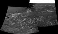
Posted by: Ant103 Apr 10 2007, 07:24 AM
The Bay "without" peril
http://astrosurf.com/merimages/Images_opportunity-2007.html#Sol1133
Posted by: AndyG Apr 10 2007, 08:21 AM
Absolutely beautiful, Ant. That's easily one of my Oppy favorites.
Andy
Posted by: fredk Apr 11 2007, 03:41 PM
A couple of long baseline stereo views looking down VwP to the dunes, from sols 1131 and 1133:

|

|
Posted by: jvandriel Apr 15 2007, 02:07 PM
The Panoramic view and a look in the drive direction
on Sol 1142.
Taken with the L2 pancam.
jvandriel

|
Posted by: Martial Apr 15 2007, 09:56 PM
on Sol 1142.
Taken with the L2 pancam.
jvandriel
Why you pictures are allways so little ? It's a pity. I allways hope that the next one, it will bee bigger.. but no.
Posted by: BrianL Apr 16 2007, 03:43 AM
Umm... have you tried clicking on them?
Brian
Posted by: CosmicRocker Apr 16 2007, 04:19 AM
I think he's asking why jvandriel's images are reduced in size from the original.
Posted by: jvandriel Apr 16 2007, 05:07 PM
The images are reduced in size because it's one
of the rules not to publish images bigger as 1 MB.
It has to do with backup's of the site and other
housekeeping. It take's very much time to completely
backup the site with a lot of big pano's, 6MB or even bigger.
I have no other address to download the pano's and mosaics.
I only publish the pano's here at unmannedspaceflight.com
For myself, I have now more than 2500 pano's and mosaics
for Spirit and Opportunity. Original size.
jvandriel
Posted by: alan Apr 20 2007, 03:29 AM
There are several rocks like this one with low rings near their edges. Anyone care to offer an explaination as to how these form?

|
Posted by: CosmicRocker Apr 20 2007, 04:27 AM
Be careful what you ask for, alan.
There are a variety of geological processes that can create such features. A discussion of them could quickly turn into something like the Great Dust Debate...on steroids.
They are interesting, though, aren't they? I'm tempted to speculate, but...
Posted by: fredk Apr 20 2007, 04:27 AM
Fascinating. Now what we need to do is form two camps and start a new debate!
Also in that image you can see some ripples. These are I think the first in a long time, but I think Oppy can maneuver them without difficulty!
From the new viewpoint we can just about see our arrival point to Victoria behind Verde in the upper right of this image: http://qt.exploratorium.edu/mars/opportunity/pancam/2007-04-19/1P230280809EFF81V4P2405L2M1.JPG
Posted by: mhoward Apr 20 2007, 04:51 AM
http://flickr.com/photo_zoom.gne?id=465772587&size=l http://flickr.com/photo_zoom.gne?id=465758941&context=photostream&size=l
Posted by: CosmicRocker Apr 20 2007, 05:39 AM
Don't even start to tempt me with those http://www.google.com/search?q=define%3Arelict ripples.
Posted by: fredk Apr 20 2007, 03:38 PM
Well, I guess I'll be the first to stick my nose out and take a stab at the ringed ejecta blocks.
We start with some ejecta blocks in the ejecta blanket whose surfaces have been altered in some way. Those blocks erode down in the wind, like the rest of the blanket, to the current flat apron surface. But the altered surfaces are a bit more resistant to erosion than the interiors of those blocks. The result is that the surface of the apron consists of cross-sections of all the blocks, but those with altered surfaces ("rinds"?) will have a slightly raised rim, corresponding to the rind, and a slightly depressed interior. Dark berries/sand tend to accumulate in the depressed interior, just like we see in the navcams.
Obvious questions are what caused the alteration and when did it occur. Since presumably the surfaces of the blocks were only exposed after impact, I guess the alteration had to happen after that. Could the heat of impact be responsible? Why would some blocks be altered this way but not others?
Posted by: Edward Schmitz Apr 20 2007, 07:18 PM
Perhaps the answer to that would also answer the origin of the dark matterial...
That's purely wild speculation...
Posted by: mhoward Apr 21 2007, 03:56 PM
A view of Opportunity at her sol 1150 location, more or less
http://www.flickr.com/photo_zoom.gne?id=467191562&size=l
Posted by: jvandriel Apr 21 2007, 05:20 PM
Here is the Navcam panoramic view from Sol 1150
taken with the L0 Navcam.
jvandriel
|
|
Posted by: jvandriel Apr 21 2007, 05:24 PM
and the Pancam L2 view from Sol 1150.
jvandriel

|
Posted by: Ant103 Apr 22 2007, 04:33 PM
Hi
The last panorama I've made. This is the one of the biggest Opportunity's pan I've made.
This is the Valley Without Peril :
http://astrosurf.com/merimages/Images_opportunity-2007.html#Sol1131
It was hard to make gain compensation on these pictures because of the large brightness differences between one image and an other... But I succeed to this.
Posted by: fredk Apr 23 2007, 04:52 AM
Beautiful, Ant! Thanks.
Posted by: fredk Apr 23 2007, 03:18 PM

|
It does look like there's a tougher crust around these blocks.
Posted by: CosmicRocker Apr 24 2007, 04:35 AM
Ok, this has become too interesting to ignore. I think we saw the first vestiges of this phenomenon a long time ago. It is rather curious, because some ejecta blocks exhibit it, and some do not. We've only seen down to the ejecta bedrock surface in a few areas, but it does seem to be more prevalent on the north side. More rock is exposed here, though.
My first thought upon seeing something like this is to suspect that a resistant rind formed on the blocks through some kind of secondary alteration of the blocks, such as heat from the blast or post-impact exposure to water. But it could be that something caused the central cores of the blocks to become softer and less resistant to erosion.
But, there is yet another way to look at it. We've seen plenty of blueberries piled up in various configurations around the peripheries of the blocks, and sometimes in the middle of the blocks. Atomoid has http://www.unmannedspaceflight.com/index.php?s=&showtopic=4081&view=findpost&p=88530.
I honestly don't know what the underlying cause is, but I can imagine a concentration of berries and other stuff temporarily protecting the edges of blocks from wind erosion until some time when the elevation difference between the edges and the centers of the blocks becomes great enough to encourage the berries to roll into the low areas and protect them for a while.
Whatever is the cause, it seems to be something that is occurring on the horizontal surface, since we have not seen signs of crusts or rinds on the blocks in the vertical cross sections.
Posted by: ngunn Apr 24 2007, 08:59 AM
Perhaps the rocks buried at depth were water-rich at the time of impact and their exteriors were hardened in some way by rapid dessication once exposed.
Posted by: algorimancer Apr 24 2007, 03:49 PM
Just to play devil's advocate, here's a potential mechanism which doesn't (necessarily) involve water:
Let's assume that the rocks undergo a greater temperature range in each sol than does the surrounding soil (I might expect that the soil would be somewhat insulating, whereas heat might conduct more readily through solid rock). Thus the bulk of the rock would experience a particular range of relatively uniform physical expansion/contraction over the course of a day. However, the edges of a rock - being adjacent to the insulating soil - would be more stable in temperature and thus not undergoing the extremes of expansion/contraction of the bulk of the rock. Clearly it would not be unexpected that cracks might occur along the interface between the bulk rock and the edge rock due to the differential expansion. The vicinity of these cracks would be more susceptible to wind erosion, and the net result (hundreds of millions to billions of years later) would be the surfaces we see today. One obvious question is that of why we haven't been seeing this phenomenon throughout Oppy's traverse - it seems that the composition of these rocks must be somewhat unique.
This notion would be easily tested by imaging a rock closely enough to establish whether cracks define the base of the depression along the edge, though if the depression is filled with sediment it may be necessary to use the ratt.
Posted by: imipak Apr 24 2007, 07:35 PM
A wild (wild as in "silly") idea:
Observation: a strip equidistant from the edge of each rock showing this effect has no dust or blueberries on it.
Posit: something other than gravity alone is moving dust, sand, blueberries etc off those border areas.
Hypothesis: ground vibration or movements.
It would be interesting to see a map showing the distribution of such rocks... they appear to be clustered in one location; with what other factor does that area correspond?
Posted by: Floyd Apr 24 2007, 11:42 PM
I think an explanation is the surface here (at the edge of Victoria) is being very actively shaved down by the wind.
Floyd
Posted by: CosmicRocker Apr 25 2007, 05:04 AM
It seems difficult to use water saturation to explain these, because we only see the things on the surface. I couldn't find evidence of these rims in the vertical cross sections of blocks in the capes. You might be able to come up with a scenario where frost, capillary films, precipitation, or some such is involved at the surface.
I devoted several hours to looking through panoramas from the larger mission tonight. The earliest location where I found similar, unambiguous features was at Cabo Anonimo, at around sol 1030. There were very few maybes from earlier dates. Cabo Anonimo was the first area around the rim of this crater where the surface bedrock was clearly visible to Opportunity, so these things might have been present, but buried at other locations. The only other surface I found that was broadly similar was that around Endurance, but the ejecta blocks were mostly covered completely by concretions and soil. There were some blocks that had their edges covered by obvious concentrations of outlining berries, but the underlying rock was not visible.
I also noticed plenty of blocks everywhere that were partially outlined by berry piles, and which did not display these curious features. We need more ideas, or observations.
Posted by: jvandriel Apr 25 2007, 07:00 PM
The L0 Navcam view from Sol 1153.
jvandriel

|
Posted by: jvandriel Apr 25 2007, 07:36 PM
Here is the view from Sol 1155.
Taken with the L0 Navcam.
jvandriel
|
|
Posted by: atomoid Apr 25 2007, 10:19 PM
more food snacks for thought...
- if the raised outline piles are not http://www.unmannedspaceflight.com/index.php?s=&showtopic=4081&view=findpost&p=88530 co-evolved with disintegrating evaporite chunks, then...
- examine the http://mars.lyle.org/imagery/1N230544886EFF81XLP0785L0M1.JPG.html for a prime example of a crack boundary berry pile.
It looks so much as if the berry piles have been extruded from or pushed out of the crack area, almost as if the bedrock were a plate that had been lifted and fell back down and left a berry splash at one side. although there doesn't seem to be any reasonable method this could occur. we could play devil's advocate with some radical contraction/expansion model: in addition to Algorimancer's temperature-based model above, how much water can the sulfates adsorb/lose over time? and maybe there are other factors such as underground water freezing related expansion as well..
..if there is enough related contration/expansion considering all factors, it might form some sort of pushing mechanism that builds the little piles up over time, spilling out on one side or another and remaining until the next cycle. From looking around, it seems that most of the cracks in other areas seem to be less-filled than expected, since i'd expect all cracks to be filled up with blueberries long long ago, indeed it seems as if there may be even some recent contraction that has opened them up a bit to swallow soils, and the topography of the crack might help the wind keep the dust out of them to a large degree, if the lack of material were due to lack of blueberry concentrations.
..but also consider that there may be 'pockets' of salts under the surface that were concentrated as these saturated areas underwent drying, it might have formed salt pockets that have a much greater than average amount of expansion/contraction related to this, this could of course be low enough under the surface that it subtley lifts the plates on one side or pushed up material that has fallen into the cracks. which might account for these intriguing first-order Mars-mystery features were seeing. okay i guess im rambing now...
Posted by: CosmicRocker Apr 26 2007, 04:35 AM
I find it amazing that the little jaunt back up the cape to image the other half of the LBL stereo brought us so many blocks in different stages of evolution. The sol 1155 images have me even more bewildered than ever. I still really like your "chalkmark" idea as a beginning point, but the impact is very old and there is no telling how long ago the ejecta began to erode. Supposedly, this crater was filled with sediment after the impact, which was later removed.
Who knows what modifying forces the eventual berry piles became subject to? Along much of the journey south we saw examples of berry piles along bedrock cracks. I recall Bill calling similar things "wrinkled rug structures." Back then we mostly wondered about the bedrock fractures and how they might be "sapping" fine grains away. Now, we arrive here, and we see similar things, and some really different things.
We've already seen a lot of blocks with elevated rims. Here, there are several with depressed rims. Take a look at the block left of and somewhat below center in this image. It's center is raised, and berry piles currently occupy portions of the perimeter.
http://marsrovers.jpl.nasa.gov/gallery/all/1/n/1155/1N230722646EFF81ZEP0605R0M1.HTML
Then there is an even more curiously rimmed block where part of the rim is taller than the center and part of it is lower.
http://marsrovers.jpl.nasa.gov/gallery/all/1/r/1155/1R230721936EFF81ZEP1312R0M1.HTML
I only hope there might be a geomorphologist with influence who can get us a bottom row of pancams here. I am beginning to wonder if these concretions might serve a dual purpose. Sometimes they protect the rock from wind erosion and sometimes they might promote it.
Posted by: fredk Apr 26 2007, 03:11 PM
Whatever is the cause, it seems to be something that is occurring on the horizontal surface, since we have not seen signs of crusts or rinds on the blocks in the vertical cross sections.
Posted by: atomoid Apr 26 2007, 10:02 PM
Good catch on pointing out these beveled/anti-beveled block edges ...i am stumped, but i like that last sentence, for a brief moment i saw berries rolling around in the wind clanging together much like the little pebbles eroding out their little bowls in streambeds and coastal bedrock.
Posted by: CosmicRocker Apr 27 2007, 04:41 AM
atomoid: To be honest, it leaves me wanting, but it was all I could imagine from the imagery at hand. It is so fun when our little machines send back these intriguing observations from an alien world. I'm still open to new ideas, but I am stumped, too.
fredk: That's right. I may not have explained myself well enough. You would not expect the concretions to be involved in that process unless it was something taking place on a roughly horizontal surface. When I said we haven't seen rinds on the blocks in vertical sections, I was only arguing that this phenomenon was not likely the result of earlier events (secondary processes) that altered the perimeters of those blocks, like having been saturated with water or melted by heat.
Posted by: jvandriel Apr 29 2007, 02:33 PM
Here is the Pancam L2 view from Sol 1155.
jvandriel

|
Posted by: Shaka Apr 30 2007, 06:25 PM
This Bud's for you, Arthur C.!
http://qt.exploratorium.edu/mars/opportunity/navcam/2007-04-30/1N230898859EDN814WF0006L0M1.JPG
Posted by: Gray Apr 30 2007, 11:10 PM
"Deliberately buried?...."
(I'll also raise a glass to Stanley K. for the outstanding visuals.)
Posted by: mhoward May 1 2007, 12:29 AM
There's a nice view on Sol 1160, taken at about 3:15 pm local Mars time. It's a bit difficult to compensate for the glare, though.
http://www.flickr.com/photo_zoom.gne?id=479119995&size=l
Posted by: CosmicRocker May 1 2007, 04:54 AM
Shaka: Good catch, but weren't there supposed to be apes wielding jawbones, or at least some angry algae in that image?
mhoward: That view caught my eyes, too. Wasn't that a rather smooth, inverse "S" drive?
Posted by: Shaka May 1 2007, 06:08 AM
The events at the Meridiani Monolith were judged "too melodramatic", and ended on the cutting room floor. 
This maneuver is just early training for the Duck Bay Giant Slalom.
Posted by: Astro0 May 1 2007, 07:12 AM
Sorry, but that was an image too good to miss.
A little creative licence.
Enjoy
Astro0

|
"My God! It's full of Fines".
Posted by: dvandorn May 1 2007, 04:56 PM
"As you can see, Dr. Floyd, MMA-1 is very well depicted in these magnetometer graphs. In fact, that's how we found the damned thing."
"Deliberately buried, eh?"
-the other Doug
Posted by: Gray May 1 2007, 07:10 PM
Thanks for finding the greater part of the quotation. All I could remember was the "deliberately buried" part.
Posted by: fredk May 1 2007, 11:11 PM
Posted by: mchan May 2 2007, 03:08 AM
When are they going to try the RAT on it?
Posted by: fredk May 2 2007, 03:42 PM
Long baseline stereo view looking across CSV, Corrientes + Hoy, and Desire from sols 1155 and 1157. I love these long baseline views of distant capes.

|
Posted by: CosmicRocker May 3 2007, 04:07 AM
That's one of the best yet.
Posted by: jvandriel May 6 2007, 11:35 AM
Here is a panoramic view of Victoria Crater
taken with the L2 Pancam on Sol 1163.
jvandriel
|
Posted by: mhoward May 7 2007, 03:25 AM
Here's a new little http://homepage.mac.com/michaelhoward/.Movies/OpportunitySol1129-1137.mov. (Quicktime, 4.4Mb)
(It's a bit bouncy in spots, I know.)
Posted by: fredk May 7 2007, 05:01 PM
That's a stunning piece of work, mhoward! You've got the distant features rock steady and level. Was that done automatically based on the rover orientation data or did you line things up and rotate the images by hand?
Posted by: mhoward May 7 2007, 05:41 PM
Thanks, fredk. It's based on the rover orientation data. The movies are actually just a series of screenshots from MMB2.0's panorama feature. There's an http://homepage.mac.com/michaelhoward/.Movies/OpportunitySol1061-1066.mov that was posted to the MMB topic. And off topic for an Opportunity thread: I don't know if I ever posted this http://homepage.mac.com/michaelhoward/.Movies/SpiritSol716-732Nav.mov.
Posted by: Tman May 7 2007, 07:35 PM
Great works! Additionally I love the fact it is in QT format, so you can "drive" backward and forward, in different speed, as many you like (by using the arrow keys). Very nice feeling!
Posted by: jvandriel May 7 2007, 07:54 PM
Here is a Panoramic view from a small crater taken on Sol 1160
with the L2 Pancam.
jvandriel
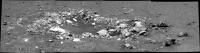
|
Posted by: fredk May 8 2007, 04:08 AM
Powered by Invision Power Board (http://www.invisionboard.com)
© Invision Power Services (http://www.invisionpower.com)