Meridiani cratering, did a shallow sea overlie heavily cratered terrain? |

  |
Meridiani cratering, did a shallow sea overlie heavily cratered terrain? |
 Sep 14 2006, 02:17 AM Sep 14 2006, 02:17 AM
Post
#1
|
|||
 Senior Member  Group: Members Posts: 3419 Joined: 9-February 04 From: Minneapolis, MN, USA Member No.: 15 |
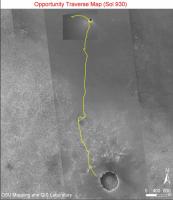
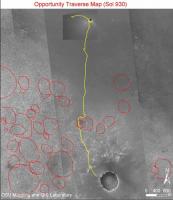
I was just looking at the large-scale Opportunity route map done by OSU Mapping/GIS Laboratory, and my impression that the etched terrain overlies what was once heavily cratered terrain was highly reinforced. Here is the original OSU/GIS route map:
I see what looks like the highly eroded remnants of rather heavily cratered terrain all throughout the etched terrain to the west of Oppy's route. Here is a version of that same image that I have somewhat roughly annotated with red circles that approximate many of the ancient craters I think I can see:
Sorry about the crudity of my drawings -- all I have available is MS Paint to do this kind of thing. Anyway, this gives me the impression that the area was once heavily cratered. The question is, are the ancient craters features that predated the deposition of the evaporite, or have they just eroded down because they were made in the very soft evaporite layer? I'd think that these craters would be so large that they would easily penetrate well beneath the evaporite layer -- so my bet would be that the ancient craters were worn down by water, after which the evaporite was laid down on top of them. That would explain why they are so subdued. Since we have actually visited the rim of one of these craters (Erebus), it seems to me we ought to be able to make some kind of judgment as to whether these craters were made before or after the deposition of the evaporite. -the other Doug -------------------- The trouble ain't that there is too many fools, but that the lightning ain't distributed right. -Mark Twain
|
||
 |
 
|
||
|
Sep 14 2006, 02:48 AM
Post
#2
|
|
|
Senior Member Group: Members Posts: 2998 Joined: 30-October 04 Member No.: 105 |
I tossed that idea around last year when we first reached "The Erebus Highway". There are many 'ghost' craters on the etched terrain, enough to make it look like the heavily cratered southern highlands. I initially assumed that the Meridiani dune/playa/lake area was essentially flat and was cratered after the deposition of the evaporite facies, but after thinking it over, there is nothing to suggest that the cratered surface is young or contemporaneous with the evaporites. Further, the etched terrain (sub)surface likely extends north and south under the current sandy plains. I've been trying to think of ways to tell if we are looking at pre- or post-evaporite craters. It did seem that the evaporite blanketed the Payson bluff, but I suspect that there was erosion along the rim and slumping, much like we see at Victoria.
It might take another wheels-on-the-ground mission to figure out the order of this layer-cake. This would be a good application for sonar or seismo instrumentation on a rover. --Bill -------------------- |
|
|
|
|
Sep 14 2006, 02:56 AM
Post
#3
|
|
|
Newbie Group: Members Posts: 10 Joined: 20-April 05 Member No.: 293 |
QUOTE (dvandorn @ Sep 13 2006, 07:17 PM)  I was just looking at the large-scale Opportunity route map done by OSU Mapping/GIS Laboratory, and my impression that the etched terrain overlies what was once heavily cratered terrain was highly reinforced. Here is the original OSU/GIS route map: [.... Since we have actually visited the rim of one of these craters (Erebus), it seems to me we ought to be able to make some kind of judgment as to whether these craters were made before or after the deposition of the evaporite.... -the other Doug Really? When I look at this, it reminds me of the shapes/patterns of a dried-up precipitate field. I don't have any of my own pictures handy, but I Googled "salt flats", and came up with a few suggestive pics: On a large scale: http://www.luminous-landscape.com/1photo-pages/s/salt.shtml On a smaller scale: http://www.gplphotography.com/Death%20Vall...alt%20Flats.htm Of course, the bane and blessing of humans is we see patterns in everything, whether they are there or not. |
|
|
|
|
Sep 14 2006, 03:54 AM
Post
#4
|
|
|
Senior Member Group: Members Posts: 1582 Joined: 14-October 05 From: Vermont Member No.: 530 |
Erebus was generally accepted to be within a older larger crater called Terra Nova. The general theme of drawing circles on the etched terrain outcrops was done here:
http://www.unmannedspaceflight.com/index.p...p;hl=terra+nova I seem to recall some other folks doing the same exercise in some other forum, that I used to read before getting fed up with people xenopogenecizing rocks. 
|
|
|
|
|
Sep 14 2006, 04:23 PM
Post
#5
|
|
|
Member Group: Members Posts: 109 Joined: 9-April 04 Member No.: 66 |
"xenopogenecizing"
Googled it... http://www.google.com/search?ie=UTF-8&q=xenopogenecize Excellent creatosynthesizing of linguistics!! 
|
|
|
|
|
Sep 14 2006, 05:21 PM
Post
#6
|
|
 Member Group: Members Posts: 198 Joined: 2-March 05 From: Richmond, VA USA Member No.: 181 |
Far OT, but irresistable:
 -- Pertinax |
|
|
|
|
Sep 14 2006, 05:29 PM
Post
#7
|
|
|
Senior Member Group: Members Posts: 1582 Joined: 14-October 05 From: Vermont Member No.: 530 |
QUOTE (gregp1962 @ Sep 14 2006, 12:23 PM) Excellent creatosynthesizing of linguistics!! Compoundification, even. Or dumbfoundiment. 
|
|
|
|
|
Sep 14 2006, 06:11 PM
Post
#8
|
|
|
Senior Member Group: Members Posts: 2998 Joined: 30-October 04 Member No.: 105 |
QUOTE fed up with people xenopogenecizing rocks... I went 'huh?', googled the word, said 'I _thought_ that he made that up', noticed who he was talking about, and then thought 'I agree'. --Bill -------------------- |
|
|
|
|
Sep 14 2006, 07:21 PM
Post
#9
|
|
|
Member Group: Members Posts: 100 Joined: 20-May 06 Member No.: 780 |
re: Calvin & Hobbes.....
There is no word in the English language which cannot be adjectived. |
|
|
|
|
Sep 14 2006, 07:41 PM
Post
#10
|
|
|
Member Group: Members Posts: 688 Joined: 20-April 05 From: Sweden Member No.: 273 |
QUOTE (diane @ Sep 14 2006, 09:21 PM) re: Calvin & Hobbes..... There is no word in the English language which cannot be adjectived. So what's the adjectival form of "the"? tty |
|
|
|
|
Sep 15 2006, 10:51 AM
Post
#11
|
|
|
Member Group: Members Posts: 307 Joined: 16-March 05 Member No.: 198 |
QUOTE (diane @ Sep 14 2006, 07:21 PM) re: Calvin & Hobbes..... There is no word in the English language which cannot be adjectived. I suspect you mean "adjectivized". ====== Stephen |
|
|
|
|
Sep 15 2006, 11:33 AM
Post
#12
|
|
|
Member Group: Members Posts: 307 Joined: 16-March 05 Member No.: 198 |
QUOTE (Bill Harris @ Sep 14 2006, 02:48 AM) It might take another wheels-on-the-ground mission to figure out the order of this layer-cake. This would be a good application for sonar or seismo instrumentation on a rover. I suspect it will more likely probably take a manned mission or two and lots of samples collected from a variety of places and returned to Earth labs for in-depth analysis before any acceptably definitive answer appears, much as was the case with the Moon. That said the very difference between a heavily cratered southern hemisphere versus a much more sparsely cratered north surely suggests some kind of hypothesis along the lines of Doug's suggestion. At some point in its early history all of Mars must have been as heavily cratered as the south. Whatever the mechanism was it was selective, eroding or covering over the ancient craters of the north while leaving the south's comparatively intact. Lava could have done that, as on the Moon's maria. But we're not seeing lava fields at Meridani. Opportunity's data is suggesting wide expanses of sedimentary rocks. Wind might be responsible for some of that, but it can't be responsible for most of it otherwise we'd expect to see the southern hemisphere in a state more similar to that of the north. That would seem to leave some kind of some sort of aqueous fluid, whether ice or liquid water, as being the agent responsible; and the very extensiveness of those northern plains suggests there must once have been a lot of it. For it's surely taken more than a trickle of ground water over the eons to remove so many of the north's ancient crater fields whilst leaving the south's more or less intact. ====== Stephen |
|
|
|
|
Sep 15 2006, 12:20 PM
Post
#13
|
|
|
Senior Member Group: Members Posts: 2998 Joined: 30-October 04 Member No.: 105 |
Or "adjectivised", depending on which side of The Pond you're on.
Yes, the great North-South Dichotomy will take boots on the ground to understand. --Bill -------------------- |
|
|
|
|
Sep 15 2006, 12:48 PM
Post
#14
|
|
 Member Group: Members Posts: 562 Joined: 29-March 05 Member No.: 221 |
QUOTE (tty @ Sep 14 2006, 08:41 PM) So what's the adjectival form of "the"? 'teh' I kid you not. |
|
|
|
|
Sep 15 2006, 12:54 PM
Post
#15
|
|
|
Senior Member Group: Members Posts: 2998 Joined: 30-October 04 Member No.: 105 |
>I kid you not.
I'll be darned. I thought it was just a silly typo. --Bill -------------------- |
|
|
|
|

|
Lo-Fi Version | Time is now: 28th April 2024 - 07:40 AM |
|
RULES AND GUIDELINES Please read the Forum Rules and Guidelines before posting. IMAGE COPYRIGHT |
OPINIONS AND MODERATION Opinions expressed on UnmannedSpaceflight.com are those of the individual posters and do not necessarily reflect the opinions of UnmannedSpaceflight.com or The Planetary Society. The all-volunteer UnmannedSpaceflight.com moderation team is wholly independent of The Planetary Society. The Planetary Society has no influence over decisions made by the UnmannedSpaceflight.com moderators. |
SUPPORT THE FORUM Unmannedspaceflight.com is funded by the Planetary Society. Please consider supporting our work and many other projects by donating to the Society or becoming a member. |
|