Opportunity Route Map |

  |
Opportunity Route Map |
 May 28 2006, 09:01 PM May 28 2006, 09:01 PM
Post
#1441
|
|
|
Member  Group: Members Posts: 178 Joined: 13-September 05 Member No.: 498 |
QUOTE (CosmicRocker @ May 28 2006, 12:04 AM)  The Oppster has been really cleaning out the attic in recent updates. In the past, this has signified the commencement of a major advancement campaign. Can we expect a serious attempt to add mileage to the odometer? Mmm.. I noticed all the past images being offloaded but I hadn't associated it with the prospect of an aggressive driving campaign... I hope you're right! |
 |
 
|
|
May 28 2006, 09:12 PM
Post
#1442
|
|
 Dublin Correspondent Group: Admin Posts: 1799 Joined: 28-March 05 From: Celbridge, Ireland Member No.: 220 |
QUOTE (Joffan @ May 28 2006, 10:01 PM) Mmm.. I noticed all the past images being offloaded but I hadn't associated it with the prospect of an aggressive driving campaign... I hope you're right! So do I but I think they might be preparing for the software update, and that might throw a complete spanner in the works for both the arrival at Victoria pool and the "Where is the Beacon" soccer match. |
|
|
|
|
May 29 2006, 10:09 AM
Post
#1443
|
||
|
Senior Member Group: Moderator Posts: 4279 Joined: 19-April 05 From: .br at .es Member No.: 253 |
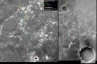
An updated route map after sol 833 "drive".
Edited: Corrected wrong sol number. This post has been edited by Tesheiner: May 29 2006, 01:43 PM |
|
|
|
|
|
|
May 29 2006, 12:18 PM
Post
#1444
|
|
 Member Group: Members Posts: 362 Joined: 12-June 05 From: Kiama, Australia Member No.: 409 |
QUOTE (Tesheiner @ May 29 2006, 08:09 PM) An updated route map after sol 833 "drive". [attachment=5934:attachment] Deviate from Tesheiner's route at your peril QUOTE Opportunity in a sandtrap, again
A thread for the topic http://www.unmannedspaceflight.com/index.p...wtopic=2788&hl= |
|
|
|
|
May 30 2006, 03:54 PM
Post
#1445
|
|
|
Member Group: Members Posts: 295 Joined: 2-March 04 From: Central California Member No.: 45 |
It looks like there is no way to avoid going over some of the dunes between here and Corner Crater. Hopefully, when Oppy is unstuck again, a better more careful route can be derived. We don't need to make it to VC until Sol 933 anyway

-------------------- Eric P / MizarKey
|
|
|
|
|
May 30 2006, 05:30 PM
Post
#1446
|
|
 Senior Member Group: Members Posts: 1229 Joined: 24-December 05 From: The blue one in between the yellow and red ones. Member No.: 618 |
Your concern for Oppy's welfare is deeply moving, Eric.
-------------------- My Grandpa goes to Mars every day and all I get are these lousy T-shirts!
|
|
|
|
|
Jun 1 2006, 05:34 AM
Post
#1447
|
||
 Senior Member Group: Members Posts: 2228 Joined: 1-December 04 From: Marble Falls, Texas, USA Member No.: 116 |
Yes. I was so moved that I looked around for something or someone to hug. The nearest victim was a pair of red/cyan glasses.
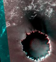
 I wanted to post some recent observations. This might better belong in one of the other threads, but since it relates to my interest in observing Opportunity's movements, I'll drop it here. We've recently seen Opportunity's path move into a region for which decent 3D orbital imagery is available. I have long been awaiting this. It would have been nice to have such coverage available for the whole route map. Although the parallax on the plains is minimal, it seems that we can observe some of the topography. It appears to me that Opportunity has recently decended into an ancient crater whose circular outline is apparent on Tesheiner's maps. The decent can be seen in recent anaglyphs from Opportunity. It appears to me that the crater's basin is directly in our path, and I wonder if the aeolian sediment in this crater is more treacherous than elsewhere, and responsible for the recent wheel embedding hazard. The attached file is an anaglyph of orbital imagery for this area. It's rough, but it has 4 yellow dots corresponding to the last four locations of the rover on Tesh's last map. It might have had five locations, but I did not distinguish between his last two.
Attached thumbnail(s)
-------------------- ...Tom
I'm not a Space Fan, I'm a Space Exploration Enthusiast. |
|
|
|
|
|
|
Jun 1 2006, 07:29 AM
Post
#1448
|
|
|
Member Group: Members Posts: 111 Joined: 14-March 05 From: Vastitas Borealis Member No.: 193 |
Anaglyphs are definitely a more practical way to see maps in 3D, compared to my Xeyed version previously. Thanks for sending this image. Will save me from the risk of getting my eyes permanently crossed due to my working methods, and several other people from some splitting headaches if you instead of me keep sending these maps every now and then.
-- And yes, there seem to be a noticeable depression and some even bigger-looking dunes ahead of Oppy. I think there's no going there now and she must be backed and driven to west to follow the 'original' paved path. |
|
|
|
|
Jun 1 2006, 08:33 AM
Post
#1449
|
|
|
Junior Member Group: Members Posts: 64 Joined: 24-May 06 From: Aberdeen, Scotland Member No.: 785 |
James recently helped me out on a question I had about site drive number changes and their correlation to driving distances.
QUOTE (jamescanvin @ May 27 2006, 06:03 AM) For a drive increment of 36 (which is for example xxDx to xxEx etc.) the rover will have moved approximately 6 meters. Of course a change in driving stratagy/aggressiveness could change all this overnight. Here ends this pointless exersice, make driving distance estimates from drive numbers at you peril.  James Oppy's current predicament got me thinking about this again. It seems to me someone somewhere (in JPL) must be deciding what the site location is going to be called. I can't believe the naming is a random process and therefore it seems logical to tie it to distance. The first attempt to extract Oppy from the latest sand trap has resulted in a drive site change from 71GB to 71GG, a change of 5 units on the fourth character. Perhaps this equates to 5 cm, but they would have commanded a much longer drive to achieve this. I'm now wondering if the site drive location is more related to commanded driving distances rather than actual drive distances achieved. This would make some sense, as they probably have to decide on the site number for file naming before the drive takes place, images are taken and then sent to Earth. Here continues this pointless exercise  - but think of the benefits if we could actually work out precise driving distances from the site numbers. - but think of the benefits if we could actually work out precise driving distances from the site numbers.Castor |
|
|
|
|
Jun 1 2006, 08:53 AM
Post
#1450
|
|
|
Founder Group: Chairman Posts: 14432 Joined: 8-February 04 Member No.: 1 |
QUOTE (Castor @ Jun 1 2006, 09:33 AM) I can't believe the naming is a random process and therefore it seems logical to tie it to distance. No - it really is just a drive number. Currently, because they use regular visidom slip checks, each instance of that will trigger a new site number - and I believe they do these every 6 or so metres..ish. Of course, if you do a lot of tiny short drives with lots of imaging in an attempt to say, get out of a dune, then you'll crank up the drive number quite quickly. I think they may have done 4 intermedite imaging sequences and one end imaging sequence with the first drive-out-of-dune sequence, which would = an increase in drive number of 5. It's not related to distance driven, just number of drives done. Doug |
|
|
|
|
Jun 1 2006, 09:09 AM
Post
#1451
|
|
|
Senior Member Group: Moderator Posts: 4279 Joined: 19-April 05 From: .br at .es Member No.: 253 |
QUOTE (Castor @ Jun 1 2006, 10:33 AM) Oppy's current predicament got me thinking about this again. It seems to me someone somewhere (in JPL) must be deciding what the site location is going to be called. I can't believe the naming is a random process and therefore it seems logical to tie it to distance. Let's separate those two keywords because they actually behave differently. IMO, a change in site id is decided *before* the move itself; it's a sort of planning decision like "drive from A to B in driving mode X" and then "reset to a new site id". Changes in drive id are (imo) determined automatically by the rover (call those changes "steps") but I don't see those steps related to distance. QUOTE I'm now wondering if the site drive location is more related to commanded driving distances rather than actual drive distances achieved. This would make some sense, as they probably have to decide on the site number for file naming before the drive takes place, images are taken and then sent to Earth. The "steps" are almost certainly related to commanded drive and not actual drive, but not necessarly to distance. Instead of using the current situation as an example, we could go back to Purgatory I. On that time, what happened (have a look to the daily change in drive ids *and* the MER status reports) was that sometimes a step was equivalent to 0.2m, some other ones to 2.0m, and iirc they also had 12m steps executed. And here we are not talking of autonomous driving modes; in those cases who knows (ok, rover drivers will for sure) how to translate "steps" in meters? |
|
|
|
|
Jun 1 2006, 09:31 AM
Post
#1452
|
|
|
Founder Group: Chairman Posts: 14432 Joined: 8-February 04 Member No.: 1 |
Every time the vehicle drives, the drive number increases. It's not related to distance at all.
After a significant drive, a new site number is declared and the drive number resets to zero. Now - when you're doing mid-drive imaging (like visidom for slip check or documenting egress progress from a dune) - you have to drive...stop...take images...and drive again..and repeat. Each time you do that - you increase the drive number... Thus yesterday's driving... http://qt.exploratorium.edu/mars/opportuni...GBP1230L0M1.JPG http://qt.exploratorium.edu/mars/opportuni...GCP1244L0M1.JPG http://qt.exploratorium.edu/mars/opportuni...GDP1244L0M1.JPG http://qt.exploratorium.edu/mars/opportuni...GEP1244L0M1.JPG http://qt.exploratorium.edu/mars/opportuni...GFP1244L0M1.JPG http://qt.exploratorium.edu/mars/opportuni...GGP1214L0M1.JPG or, more briefly... 1F202400423EFF71GBP1230L0M1.JPG 1F202402217ESF71GCP1244L0M1.JPG 1F202402594ESF71GDP1244L0M1.JPG 1F202402957ESF71GEP1244L0M1.JPG 1F202403340ESF71GFP1244L0M1.JPG 1F202404009EFF71GGP1214L0M1.JPG The day would have gone... Take images at same place as yesterday Site 71, Drive GB.. Drive a bit, thus completing drive GC take images Drive a bit more, thus going to GD take images etc etc - up to GG Tomorrow, we may see a similar increase, starting with GG for start of day image, then subframes of progress with GH, GI, GJ, GK, GL etc... Doug |
|
|
|
|
Jun 1 2006, 09:38 AM
Post
#1453
|
|
|
Junior Member Group: Members Posts: 64 Joined: 24-May 06 From: Aberdeen, Scotland Member No.: 785 |
Doug, Tesheiner, James,
Thanks for the replies. Makes much more sense now. This pointless exercise is hereby concluded for me too! Castor |
|
|
|
|
Jun 1 2006, 09:49 AM
Post
#1454
|
|
|
Senior Member Group: Members Posts: 2998 Joined: 30-October 04 Member No.: 105 |
Tom, it is clear that Oppy is headed into an old crater, the depression means a lower wind velocity and net deposition of sand and apparently softer sand.
I'll suspect that Oppy will go a biy westward and step along the outcrop stepping stones instead of staying due south. --Bill -------------------- |
|
|
|
|
Jun 1 2006, 10:32 AM
Post
#1455
|
|
|
Senior Member Group: Moderator Posts: 4279 Joined: 19-April 05 From: .br at .es Member No.: 253 |
QUOTE (djellison @ Jun 1 2006, 11:31 AM) Every time the vehicle drives, the drive number increases. Referring to this document ("The Mars Exploration Rover Surface Mobility Flight Software: Driving Ambition"), I think a drive number increment is triggered whenever a "Low Level driving primitive" is executed. They may be automatically commanded by the rover (in autonav modes) or directly commanded from the ground. The latter was almost sure yestersol's driving mode. Edited: Finished from my side too; it's getting too technical to fit in this thread. |
|
|
|
|

|
Lo-Fi Version | Time is now: 25th April 2024 - 09:01 AM |
|
RULES AND GUIDELINES Please read the Forum Rules and Guidelines before posting. IMAGE COPYRIGHT |
OPINIONS AND MODERATION Opinions expressed on UnmannedSpaceflight.com are those of the individual posters and do not necessarily reflect the opinions of UnmannedSpaceflight.com or The Planetary Society. The all-volunteer UnmannedSpaceflight.com moderation team is wholly independent of The Planetary Society. The Planetary Society has no influence over decisions made by the UnmannedSpaceflight.com moderators. |
SUPPORT THE FORUM Unmannedspaceflight.com is funded by the Planetary Society. Please consider supporting our work and many other projects by donating to the Society or becoming a member. |
|