Solander Point, Sol 3387 - 3511 (August 4, 2013 - December 12, 2013) |

  |
Solander Point, Sol 3387 - 3511 (August 4, 2013 - December 12, 2013) |
 Dec 6 2013, 08:56 PM Dec 6 2013, 08:56 PM
Post
#271
|
||
|
Senior Member  Group: Members Posts: 2820 Joined: 22-April 05 From: Ridderkerk, Netherlands Member No.: 353 |
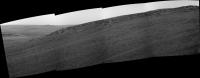
The Pancam L 7 view on Sol 3508.
Jan van Driel
|
|
 |
 
|
|
|
Dec 6 2013, 09:39 PM
Post
#272
|
||
 Senior Member Group: Moderator Posts: 3431 Joined: 11-August 04 From: USA Member No.: 98 |
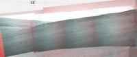
Here's an anaglyph version of the sol 3508 drive direction mosaic if anyone would like.
Attached thumbnail(s)
|
|
|
|
|
|
|
Dec 7 2013, 03:17 AM
Post
#273
|
|
 Senior Member Group: Members Posts: 4246 Joined: 17-January 05 Member No.: 152 |
|
|
|
|
|
Dec 7 2013, 06:52 PM
Post
#274
|
||
|
Solar System Cartographer Group: Members Posts: 10151 Joined: 5-April 05 From: Canada Member No.: 227 |
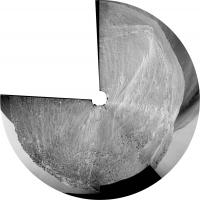
This is the 3506 position in a circular image based on jvandriel's original panorama.
Phil
-------------------- ... because the Solar System ain't gonna map itself.
Also to be found posting similar content on https://mastodon.social/@PhilStooke Maps for download (free PD: https://upload.wikimedia.org/wikipedia/comm...Cartography.pdf NOTE: everything created by me which I post on UMSF is considered to be in the public domain (NOT CC, public domain) |
|
|
|
|
|
|
Dec 7 2013, 08:50 PM
Post
#275
|
|
|
Solar System Cartographer Group: Members Posts: 10151 Joined: 5-April 05 From: Canada Member No.: 227 |
And we have a name! Cook Haven. I hope it lives up to its namesake.
http://www.midnightplanets.com/web/MERB/im...MP2378L7M1.html Phil -------------------- ... because the Solar System ain't gonna map itself.
Also to be found posting similar content on https://mastodon.social/@PhilStooke Maps for download (free PD: https://upload.wikimedia.org/wikipedia/comm...Cartography.pdf NOTE: everything created by me which I post on UMSF is considered to be in the public domain (NOT CC, public domain) |
|
|
|
|
Dec 8 2013, 03:42 PM
Post
#276
|
|
 Member Group: Members Posts: 547 Joined: 1-May 06 From: Scotland (Ecosse, Escocia) Member No.: 759 |
Is anyone else curious to see what Cape York looks like from up here, as I am?
|
|
|
|
|
Dec 8 2013, 04:34 PM
Post
#277
|
|
|
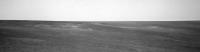
Senior Member Group: Moderator Posts: 3431 Joined: 11-August 04 From: USA Member No.: 98 |
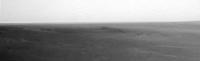
It looks like this (upper left) - but yes, let's hope we see some great Pancam coverage at some point during the winter. Let's just hope she isn't developing a case of trench wheel.
|
|
|
|
|
Dec 8 2013, 04:43 PM
Post
#278
|
|||
|
Solar System Cartographer Group: Members Posts: 10151 Joined: 5-April 05 From: Canada Member No.: 227 |
Mike beat me to it by a second or two, but this is my version, merging both frames from that sequence and brightening (and enlarging). Pancam should look pretty good when we get it.
Phil
EDIT: added a sol 3499 version showing Nobby's Head as well)
-------------------- ... because the Solar System ain't gonna map itself.
Also to be found posting similar content on https://mastodon.social/@PhilStooke Maps for download (free PD: https://upload.wikimedia.org/wikipedia/comm...Cartography.pdf NOTE: everything created by me which I post on UMSF is considered to be in the public domain (NOT CC, public domain) |
||
|
|
|
||
|
Dec 8 2013, 05:15 PM
Post
#279
|
|
 Senior Member Group: Members Posts: 2492 Joined: 15-January 05 From: center Italy Member No.: 150 |
Looking to apparent horizon, these images confirm that both structures (Cape York and Nobby's Head) are within Endeavour depression and, as suggested from elevation charts, Opportunity will not go significantly above Meridian plain level by climbing the Murray ridge, making impossible to see farther features like Victoria or Endurance craters...
 -------------------- I always think before posting! - Marco -
|
|
|
|
|
Dec 8 2013, 05:36 PM
Post
#280
|
|
|
Solar System Cartographer Group: Members Posts: 10151 Joined: 5-April 05 From: Canada Member No.: 227 |
Ah, but wait until next year when we're on top of Cape Tribulation!
Phil -------------------- ... because the Solar System ain't gonna map itself.
Also to be found posting similar content on https://mastodon.social/@PhilStooke Maps for download (free PD: https://upload.wikimedia.org/wikipedia/comm...Cartography.pdf NOTE: everything created by me which I post on UMSF is considered to be in the public domain (NOT CC, public domain) |
|
|
|
|
Dec 9 2013, 08:58 AM
Post
#281
|
|
|
Member Group: Members Posts: 547 Joined: 1-May 06 From: Scotland (Ecosse, Escocia) Member No.: 759 |
Many thanks, guys. Even with the low-res, this shows very clearly how those features are on the down slope into Endeavour, and how flat they are.
|
|
|
|
|
Dec 9 2013, 12:25 PM
Post
#282
|
||
|
Senior Member Group: Members Posts: 2820 Joined: 22-April 05 From: Ridderkerk, Netherlands Member No.: 353 |
The Nav cam L0 images from Sol 3507 (-1 image) and Sol 3509
stitched together. Jan van Driel
|
|
|
|
|
|
|
Dec 10 2013, 02:13 PM
Post
#283
|
||
|
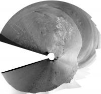
Solar System Cartographer Group: Members Posts: 10151 Joined: 5-April 05 From: Canada Member No.: 227 |
Very nice - and with a bit of geometric wizardry it becomes this circular panorama. The various outcrops can be identified quite easily on the HiRISE image now.
Phil
-------------------- ... because the Solar System ain't gonna map itself.
Also to be found posting similar content on https://mastodon.social/@PhilStooke Maps for download (free PD: https://upload.wikimedia.org/wikipedia/comm...Cartography.pdf NOTE: everything created by me which I post on UMSF is considered to be in the public domain (NOT CC, public domain) |
|
|
|
|
|
|
Dec 14 2013, 02:36 AM
Post
#284
|
|
|
Member Group: Members Posts: 866 Joined: 15-March 05 From: Santa Cruz, CA Member No.: 196 |
QUOTE (Phil Stooke @ Dec 8 2013, 09:36 AM)  Ah, but wait until next year when we're on top of Cape Tribulation! Phil brings me back to 2009 wondering what parts of the Endeavor rim we were seeing I don't think we could see anything at all from Victoria, as far as I recall it took until about sol 1920 or so when things started popping up on the horizon, though I may be off by a rise or two on that. |
|
|
|
|
Dec 14 2013, 06:41 AM
Post
#285
|
|
|
Senior Member Group: Members Posts: 4246 Joined: 17-January 05 Member No.: 152 |
We couldn't see Tribulation from Victoria, but we could see the tallest peaks on the east and north rim of Endeavour. Check out these pancam views:
http://marsrovers.jpl.nasa.gov/gallery/all...CNP2386R1M1.JPG http://marsrovers.jpl.nasa.gov/gallery/all...CNP2386R1M1.JPG |
|
|
|
|

|
Lo-Fi Version | Time is now: 25th April 2024 - 07:25 PM |
|
RULES AND GUIDELINES Please read the Forum Rules and Guidelines before posting. IMAGE COPYRIGHT |
OPINIONS AND MODERATION Opinions expressed on UnmannedSpaceflight.com are those of the individual posters and do not necessarily reflect the opinions of UnmannedSpaceflight.com or The Planetary Society. The all-volunteer UnmannedSpaceflight.com moderation team is wholly independent of The Planetary Society. The Planetary Society has no influence over decisions made by the UnmannedSpaceflight.com moderators. |
SUPPORT THE FORUM Unmannedspaceflight.com is funded by the Planetary Society. Please consider supporting our work and many other projects by donating to the Society or becoming a member. |
|