Opportunity Route Map |

  |
Opportunity Route Map |
 Aug 30 2008, 06:50 PM Aug 30 2008, 06:50 PM
Post
#2326
|
||
|
Senior Member  Group: Moderator Posts: 4279 Joined: 19-April 05 From: .br at .es Member No.: 253 |
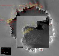
Alan, thanks for keeping the map updates during this last month!
 I'm back from vacations and no longer in "lurking mode" so here's a map update covering the whole exit path. Given that the exit route overlaps with the entry one I did a similar approach as when Opportunity drove back from "Tierra del Fuego", making the entry route darker than the exit. But in this case I'm only updating the zoom window, because the main one is too cluttered in this area.
And for the journey ahead I think it's time to start with a clean map. |
|
 |
 
|
|
|
Sep 15 2008, 09:08 AM
Post
#2327
|
||
|
Senior Member Group: Moderator Posts: 4279 Joined: 19-April 05 From: .br at .es Member No.: 253 |
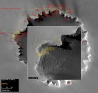
Updated route map, up to sol 1650.
Opportunity left the site at the exit point but is still in the vinicinty.
|
|
|
|
|
|
|
Sep 24 2008, 09:16 AM
Post
#2328
|
||
|
Senior Member Group: Moderator Posts: 4279 Joined: 19-April 05 From: .br at .es Member No.: 253 |
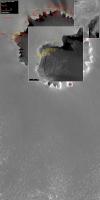
It's time to stretch the route map, don't you think so?
|
|
|
|
|
|
|
Sep 24 2008, 10:55 AM
Post
#2329
|
|
|
Senior Member Group: Members Posts: 2918 Joined: 14-February 06 From: Very close to the Pyrénées Mountains (France) Member No.: 682 |
This is the best map I've seen in over 2 years

-------------------- |
|
|
|
|
Sep 24 2008, 11:59 AM
Post
#2330
|
|
 Member Group: Members Posts: 221 Joined: 25-March 05 Member No.: 217 |
Yes a great map makes me think we are really going to get to Endeavour.
It's good the way the main picture just reaches the first part of the main 'pavement' type bedrock. Reckless |
|
|
|
|
Sep 24 2008, 12:33 PM
Post
#2331
|
|
|
Member Group: Members Posts: 530 Joined: 21-March 06 From: Canada Member No.: 721 |
In addition to the detail box inside the neighbourhood rectangle, I would like to see that rectangle inside a low res map of the the big picture, if that wouldn't be too much bother.
|
|
|
|
|
Sep 25 2008, 06:28 AM
Post
#2332
|
|
 Senior Member Group: Members Posts: 2228 Joined: 1-December 04 From: Marble Falls, Texas, USA Member No.: 116 |
QUOTE (climber @ Sep 24 2008, 05:55 AM)  This is the best map I've seen in over 2 years I'll second that.
-------------------- ...Tom
I'm not a Space Fan, I'm a Space Exploration Enthusiast. |
|
|
|
|
Sep 25 2008, 07:54 AM
Post
#2333
|
||
|
Senior Member Group: Moderator Posts: 4279 Joined: 19-April 05 From: .br at .es Member No.: 253 |
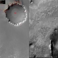
QUOTE (BrianL @ Sep 24 2008, 02:33 PM) In addition to the detail box inside the neighbourhood rectangle, I would like to see that rectangle inside a low res map of the the big picture, if that wouldn't be too much bother. Dunno if I got you right, but if you mean "neighbourhood rectangle" by the main background map (the one covering Victoria and the area to the south), is this what you want?
It would make a nice map but I see some inconveniences. The first one is that to keep the main map at the current resolution of 50cm/pix the whole image is about 4000x4000 and the file size, with a JPEG setting of 80%, is almost 1.5MB; too big (IMO) to post it drive after drive and perhaps too big for the people that might still be using dialup (I've upgraded to ADSL just 2 months ago). The second one is that my computer can barely handle such a picture; actually, Photoplus crashed once while making this test. I'm not against this map layout, actually I like it, but I'm afraid it's too big. Alternative solutions? |
|
|
|
|
|
|
Sep 25 2008, 08:14 AM
Post
#2334
|
|
 Member Group: Members Posts: 257 Joined: 18-December 04 Member No.: 123 |
Perhaps Doug could host this larger map and you could just post the reduced version with drive updates.
You could just paste in a link to the larger version (or included thumbnail) with your post if you felt so inclined. If people need to check it out they can quite easily. Great map
-------------------- Turn the middle side topwise....TOPWISE!!
|
|
|
|
|
Sep 25 2008, 08:21 AM
Post
#2335
|
|
|
Founder Group: Chairman Posts: 14431 Joined: 8-February 04 Member No.: 1 |
One thing I would say - is that 500 days of driving, with 1 meg route maps every day - is half a gigabyte of forum attachments.
I really don't think that a new attachment ever single day is the best way to do this. I'm not turning up the maximum attachment size - sorry - I have to back this forum up - so every single attachment everyone has ever downloaded - I have to download it on a regular basis to ensure a full, re-installable backup of the forum. FWIW - I really don't think we need a context map every time. It's superfluous. Maybe one every month or something, or one each time the background map moves? I don't think we need the current map to be 2k x 4k. 2k x 2k would be fine - and significantly smaller on file size. |
|
|
|
|
Sep 25 2008, 08:31 AM
Post
#2336
|
||
 Senior Member Group: Moderator Posts: 2262 Joined: 9-February 04 From: Melbourne - Oz Member No.: 16 |
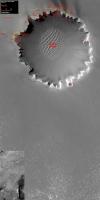
QUOTE (Tesheiner @ Sep 25 2008, 08:54 AM) I'm not against this map layout, actually I like it, but I'm afraid it's too big. Alternative solutions? I reckon you could get away with that context map being 1/4 the size it currently is and added as an insert in the corner so as to not increase the image size.
Attached thumbnail(s)
-------------------- |
|
|
|
|
|
|
Sep 25 2008, 08:40 AM
Post
#2337
|
|
|
Senior Member Group: Moderator Posts: 2262 Joined: 9-February 04 From: Melbourne - Oz Member No.: 16 |
If it's a problem I'm more than happy to host the maps.
My site has a file upload feature that I could give Tesheiner access to. Then he could just link to it here without taking up space. http://www.nivnac.co.uk/media/users/james/...ol1659.new1.jpg James -------------------- |
|
|
|
|
Sep 25 2008, 11:04 AM
Post
#2338
|
|
|
Senior Member Group: Moderator Posts: 4279 Joined: 19-April 05 From: .br at .es Member No.: 253 |
QUOTE (jamescanvin @ Sep 25 2008, 10:31 AM) I reckon you could get away with that context map being 1/4 the size it currently is and added as an insert in the corner so as to not increase the image size. That was my initial intention; background map (50cm/pix) covering the whole area and a small context map (50m/pix) located at the corner. The context map doesn't need additional space so the file size in MB basically won't change and would be defined by the size of the background map. QUOTE (djellison @ Sep 25 2008, 10:21 AM) FWIW - I really don't think we need a context map every time. It's superfluous. Maybe one every month or something, or one each time the background map moves? Agree, when speaking of a context map located beside the main one into the same file. It's a waste of space because it doesn't change. I like your suggestion to post it as a separate attachment whenever the background on the main map changes, however I still think it's a good idea to have such context map at 5m/pix in some way together with the main map on the same post. I tried sometimes to use attachments from previous posts on a new one with no luck; a link to the previous post would serve as a workaround but the other way would be, imho, a better solution. Is it possible? QUOTE (djellison @ Sep 25 2008, 10:21 AM) I don't think we need the current map to be 2k x 4k. 2k x 2k would be fine - and significantly smaller on file size. Yeah, I know. Actually the maps before reaching Victoria were even smaller then 2k x 2k. Problem is that if they really want and succeed to drive 100m/sol, a 2k x 2k map would cover only 10 driving sols. Either the map should be bigger or its scale should be changed, say to 1m/pix. QUOTE (jamescanvin @ Sep 25 2008, 10:40 AM) If it's a problem I'm more than happy to host the maps. Many thanks James, but I don't think it'll be needed. I personally think that it's a good policy to host both posts (text) and attachments on the same place. Have a look to some old threads where you can read the people discussing about a topic but the images associated to the discussion have simply gone because they are hosted somewhere else and either the owner moved from one place to another or the host changed its name. |
|
|
|
|
Sep 25 2008, 11:42 AM
Post
#2339
|
|
|
Solar System Cartographer Group: Members Posts: 10146 Joined: 5-April 05 From: Canada Member No.: 227 |
I love having these maps, but the bigger map is not necessary every time. I would suggest posting a small section covering the actual driving area after each driving sol, and the 2K by 2K map only occasionally.
Phil -------------------- ... because the Solar System ain't gonna map itself.
Also to be found posting similar content on https://mastodon.social/@PhilStooke NOTE: everything created by me which I post on UMSF is considered to be in the public domain (NOT CC, public domain) |
|
|
|
|
Sep 25 2008, 12:54 PM
Post
#2340
|
|
|
Senior Member Group: Members Posts: 2918 Joined: 14-February 06 From: Very close to the Pyrénées Mountains (France) Member No.: 682 |
QUOTE (Phil Stooke @ Sep 25 2008, 01:42 PM) I love having these maps, but the bigger map is not necessary every time. I would suggest posting a small section covering the actual driving area after each driving sol, and the 2K by 2K map only occasionally. Phil Yep, once a month, during the traverse, like TPS updates... -------------------- |
|
|
|
|

|
Lo-Fi Version | Time is now: 19th April 2024 - 03:16 AM |
|
RULES AND GUIDELINES Please read the Forum Rules and Guidelines before posting. IMAGE COPYRIGHT |
OPINIONS AND MODERATION Opinions expressed on UnmannedSpaceflight.com are those of the individual posters and do not necessarily reflect the opinions of UnmannedSpaceflight.com or The Planetary Society. The all-volunteer UnmannedSpaceflight.com moderation team is wholly independent of The Planetary Society. The Planetary Society has no influence over decisions made by the UnmannedSpaceflight.com moderators. |
SUPPORT THE FORUM Unmannedspaceflight.com is funded by the Planetary Society. Please consider supporting our work and many other projects by donating to the Society or becoming a member. |
|