Opportunity Route Map |

  |
Opportunity Route Map |
 Oct 5 2008, 04:22 PM Oct 5 2008, 04:22 PM
Post
#2356
|
||
|
Senior Member  Group: Moderator Posts: 4279 Joined: 19-April 05 From: .br at .es Member No.: 253 |
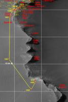
No images yet, but this is the position after sol 1670.
|
|
 |
 
|
|
|
Oct 6 2008, 06:21 PM
Post
#2357
|
|
|
Member Group: Members Posts: 206 Joined: 15-August 07 From: Shrewsbury, Shropshire Member No.: 3233 |
QUOTE (Tesheiner @ Oct 2 2008, 08:55 AM)  From september's issue of the monthly MER Update at TPS: Our goal is to drive right past Cape Pelar (sic) to the north end of Cape Victory Magellan would have called it Cabo Victoria -- and then imaging Cape Pelar (sic) which is the next promontory, Squyres said. Thats our objective for the next few sols. Then were going to the next promontory to the south and image across of the southern side of Cape Victory. And then, were going to hit the gas. This is how I understand it... If I read SS's statement correctly then there are no plans to image the high cliffs between Cape St Mary and Cape Vincent using the PanCam at either of the two promontorys where Oppy will be parked over the next few SOLs. In an ideal world I would like a few more columns would be added to the the right hand side of the planned image of Cape Victory. This enlarged image would include a clear view of the cliffs between Cape St Mary and Cape Vincent. My scientific justification for producing a slightly larger PanCam panorama is that a lot of effort has already been expended in photographing the cliffs between Cape St Mary and Cape Vincent. However there are a few sections of cliff face that could not be imaged from above. These missing sections of cliff can only be imaged from Oppy's current location. There is of course another reason for imaging these cliffs. The reason is that this enlarged PanCam could be one of the prettiest views of the entire mission. |
|
|
|
|
Oct 9 2008, 04:36 PM
Post
#2358
|
||
|
Senior Member Group: Moderator Posts: 4279 Joined: 19-April 05 From: .br at .es Member No.: 253 |
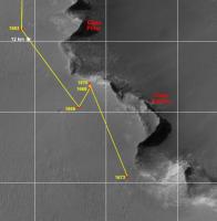
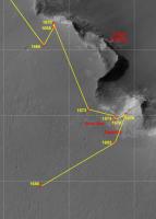
Rover's position after sol 1673.
|
|
|
|
|
|
|
Oct 9 2008, 06:10 PM
Post
#2359
|
|
|
Senior Member Group: Members Posts: 2920 Joined: 14-February 06 From: Very close to the Pyrénées Mountains (France) Member No.: 682 |
Very close to your understanding on post#2354, may be a little bit more "agressive" (closer to the rim).
-------------------- |
|
|
|
|
Oct 9 2008, 09:18 PM
Post
#2360
|
||
|
Senior Member Group: Moderator Posts: 4279 Joined: 19-April 05 From: .br at .es Member No.: 253 |
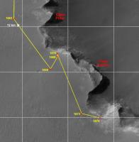
Agressive? Look at this.
Sol 1674.
|
|
|
|
|
|
|
Oct 9 2008, 10:55 PM
Post
#2361
|
|
|
Member Group: Members Posts: 530 Joined: 21-March 06 From: Canada Member No.: 721 |
Excellent draw weight. Didn't even need to be (clean) swept.

|
|
|
|
|
Oct 11 2008, 12:49 PM
Post
#2362
|
||
|
Senior Member Group: Moderator Posts: 4279 Joined: 19-April 05 From: .br at .es Member No.: 253 |
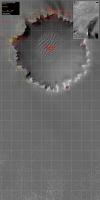
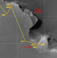
The whole picture, updated to sol 1676.
|
|
|
|
|
|
|
Oct 14 2008, 07:28 PM
Post
#2363
|
||
|
Senior Member Group: Moderator Posts: 4279 Joined: 19-April 05 From: .br at .es Member No.: 253 |
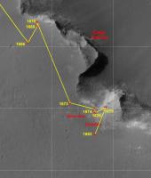
Update after sol 1679.
|
|
|
|
|
|
|
Oct 18 2008, 09:30 PM
Post
#2364
|
|
|
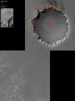
Senior Member Group: Moderator Posts: 4279 Joined: 19-April 05 From: .br at .es Member No.: 253 |
|
|
|
|
|
Oct 18 2008, 09:45 PM
Post
#2365
|
|
|
Solar System Cartographer Group: Members Posts: 10151 Joined: 5-April 05 From: Canada Member No.: 227 |
The latest JPL map gives us a name for the last cape, 'Agulhas'
Phil -------------------- ... because the Solar System ain't gonna map itself.
Also to be found posting similar content on https://mastodon.social/@PhilStooke Maps for download (free PD: https://upload.wikimedia.org/wikipedia/comm...Cartography.pdf NOTE: everything created by me which I post on UMSF is considered to be in the public domain (NOT CC, public domain) |
|
|
|
|
Oct 18 2008, 10:39 PM
Post
#2366
|
|
|
Member Group: Members Posts: 688 Joined: 20-April 05 From: Sweden Member No.: 273 |
Very fitting. Cape Agulhas (not the Cape of Good Hope) is the southernmost tip of Africa. Beyond that there is only the Southern Ocean...
|
|
|
|
|
Oct 18 2008, 11:42 PM
Post
#2367
|
|
|
Founder Group: Chairman Posts: 14432 Joined: 8-February 04 Member No.: 1 |
And Antarctica

|
|
|
|
|
Oct 19 2008, 08:54 AM
Post
#2368
|
|
|
Senior Member Group: Members Posts: 2920 Joined: 14-February 06 From: Very close to the Pyrénées Mountains (France) Member No.: 682 |
Only question remaining: will we go dead South or through Australia...
-------------------- |
|
|
|
|
Oct 21 2008, 05:59 PM
Post
#2369
|
||
|
Senior Member Group: Moderator Posts: 4279 Joined: 19-April 05 From: .br at .es Member No.: 253 |
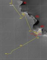
Map update after sol 1686.
To be double-checked once the navcam images are available. |
|
|
|
|
|
|
Oct 23 2008, 08:21 AM
Post
#2370
|
|||
|
Senior Member Group: Moderator Posts: 4279 Joined: 19-April 05 From: .br at .es Member No.: 253 |
Map updated after driving on sol 1687, and the big picture at half size (1m/pix).
|
||
|
|
|
||
|

|
Lo-Fi Version | Time is now: 26th April 2024 - 01:36 AM |
|
RULES AND GUIDELINES Please read the Forum Rules and Guidelines before posting. IMAGE COPYRIGHT |
OPINIONS AND MODERATION Opinions expressed on UnmannedSpaceflight.com are those of the individual posters and do not necessarily reflect the opinions of UnmannedSpaceflight.com or The Planetary Society. The all-volunteer UnmannedSpaceflight.com moderation team is wholly independent of The Planetary Society. The Planetary Society has no influence over decisions made by the UnmannedSpaceflight.com moderators. |
SUPPORT THE FORUM Unmannedspaceflight.com is funded by the Planetary Society. Please consider supporting our work and many other projects by donating to the Society or becoming a member. |
|