Unmanned landing sites from LRO, Surveyors, Lunas, Lunakhods and impact craters from hardware impacts |

  |
Unmanned landing sites from LRO, Surveyors, Lunas, Lunakhods and impact craters from hardware impacts |
 Sep 4 2015, 01:02 PM Sep 4 2015, 01:02 PM
Post
#151
|
|
 Lord Of The Uranian Rings  Group: Members Posts: 798 Joined: 18-July 05 From: Plymouth, UK Member No.: 437 |
Wow! I wonder if this area was covered by Apollo CSM or Metric Camera photography?
-------------------- |
 |
 
|
|
Sep 4 2015, 02:14 PM
Post
#152
|
|
|
Solar System Cartographer Group: Members Posts: 10160 Joined: 5-April 05 From: Canada Member No.: 227 |
The crater is only about 2 m across. There are no Apollo images of the area at any useful resolution.
Phil -------------------- ... because the Solar System ain't gonna map itself.
Also to be found posting similar content on https://mastodon.social/@PhilStooke Maps for download (free PD: https://upload.wikimedia.org/wikipedia/comm...Cartography.pdf NOTE: everything created by me which I post on UMSF is considered to be in the public domain (NOT CC, public domain) |
|
|
|
|
Sep 5 2015, 12:23 AM
Post
#153
|
|
 Senior Member Group: Members Posts: 3419 Joined: 9-February 04 From: Minneapolis, MN, USA Member No.: 15 |
Excellent find, Phil! That's exactly the kind of image I was looking for.
And, see -- once you locate hardware on the surface, the low sun images are actually helpful in characterizing them. The high-sun images would never have implied the amount of the retro-rocket that survived its final plunge intact. -the other Doug -------------------- The trouble ain't that there is too many fools, but that the lightning ain't distributed right. -Mark Twain
|
|
|
|
|
Sep 5 2015, 03:19 AM
Post
#154
|
|
|
Solar System Cartographer Group: Members Posts: 10160 Joined: 5-April 05 From: Canada Member No.: 227 |
I should say that that particular image is one of those taken from the very low orbit a few years ago before LRO moved into its current high orbit. It has a scale of 25 cm/pixel, twice as good as the best we have for any other Surveyor.
Phil -------------------- ... because the Solar System ain't gonna map itself.
Also to be found posting similar content on https://mastodon.social/@PhilStooke Maps for download (free PD: https://upload.wikimedia.org/wikipedia/comm...Cartography.pdf NOTE: everything created by me which I post on UMSF is considered to be in the public domain (NOT CC, public domain) |
|
|
|
|
Sep 29 2015, 09:29 PM
Post
#155
|
||
|
Lord Of The Uranian Rings Group: Members Posts: 798 Joined: 18-July 05 From: Plymouth, UK Member No.: 437 |
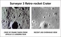
I have an exciting addendum to Phil's Surveyor 3 retro-rocket discovery, as detailed here:
http://www.planetary.org/blogs/guest-blogs...n-the-moon.html Last night, I came upon the candidate crater formed by the retro-rocket impact in the Apollo 12 descent film: https://www.youtube.com/watch?v=NlgGveDiqW4 It first appears at 3:24, is best seen around the 3:39 mark, and goes out of frame at 3:51. A frame culled from the 16-mm film (shot out of LMP Alan Bean's window), is shown below alongside a crop of the highest resolution LRO frame:
My thanks to Phil for confirming what I think is a rather interesting find: a man-made crater within walking distance of one of the Apollo landing sites! -------------------- |
|
|
|
|
|
|
Nov 27 2015, 09:43 PM
Post
#156
|
|||
|
Solar System Cartographer Group: Members Posts: 10160 Joined: 5-April 05 From: Canada Member No.: 227 |
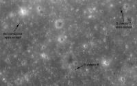
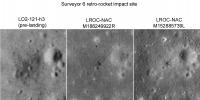
OK, it's time to prepare LPSC abstracts for next year. And what do you know, I was working on Surveyor retro-rocket images when I found that my Surveyor 6 suggestion above is wrong, and I found the real thing not far away.
This was the result of looking at Lunar Orbiter images from before the Surveyor 6 landing. LO2 frame 121-H3 reveals that the little spot I identified as the retro-rocket was there before the landing. But another one, the same distance from the lander (300 m) was NOT there before the landing. Eureka! Guess I should have done this earlier. (Unfortunately there are no pre-landing Lunar Orbiter images for Surveyor 1 or Surveyor 5) Phil
-------------------- ... because the Solar System ain't gonna map itself.
Also to be found posting similar content on https://mastodon.social/@PhilStooke Maps for download (free PD: https://upload.wikimedia.org/wikipedia/comm...Cartography.pdf NOTE: everything created by me which I post on UMSF is considered to be in the public domain (NOT CC, public domain) |
||
|
|
|
||
|
Nov 28 2015, 01:23 AM
Post
#157
|
|
|
Senior Member Group: Members Posts: 3419 Joined: 9-February 04 From: Minneapolis, MN, USA Member No.: 15 |
Oh, yeah -- it looks like you've definitely nailed it. If that's not the Surveyor VI retro-rocket, it's a very, very coincidental impact of exactly the right size, and in exactly the right place, that came from something else.
I still think the items with the highest cool factor would be to find the impact sites of Surveyors II and IV. I know that at least one of them is likely to be a small field of little craters, since it's likely that its solid-fuel retro exploded. But it would be really interesting to see the resulting impacts. (Doubtful they would be discernible, more's the pity...) -the other Doug -------------------- The trouble ain't that there is too many fools, but that the lightning ain't distributed right. -Mark Twain
|
|
|
|
|
Nov 30 2015, 01:56 AM
Post
#158
|
|
|
Solar System Cartographer Group: Members Posts: 10160 Joined: 5-April 05 From: Canada Member No.: 227 |
On a related note - not a landing site exactly - news of the Apollo 16 SIVB impact location on the Moon:
http://www.leonarddavid.com/found-impact-s...6-rocket-stage/ The location was very uncertain. I don't have coordinates yet. Phil -------------------- ... because the Solar System ain't gonna map itself.
Also to be found posting similar content on https://mastodon.social/@PhilStooke Maps for download (free PD: https://upload.wikimedia.org/wikipedia/comm...Cartography.pdf NOTE: everything created by me which I post on UMSF is considered to be in the public domain (NOT CC, public domain) |
|
|
|
|
Dec 14 2015, 06:40 PM
Post
#159
|
|
|
Solar System Cartographer Group: Members Posts: 10160 Joined: 5-April 05 From: Canada Member No.: 227 |
-------------------- ... because the Solar System ain't gonna map itself.
Also to be found posting similar content on https://mastodon.social/@PhilStooke Maps for download (free PD: https://upload.wikimedia.org/wikipedia/comm...Cartography.pdf NOTE: everything created by me which I post on UMSF is considered to be in the public domain (NOT CC, public domain) |
|
|
|
|
Dec 15 2015, 11:51 PM
Post
#160
|
||
|
Solar System Cartographer Group: Members Posts: 10160 Joined: 5-April 05 From: Canada Member No.: 227 |
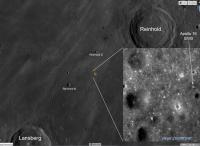
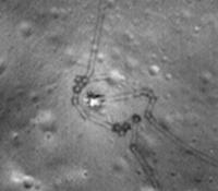
And here is a locator image if you want to find it yourself.
Phil
-------------------- ... because the Solar System ain't gonna map itself.
Also to be found posting similar content on https://mastodon.social/@PhilStooke Maps for download (free PD: https://upload.wikimedia.org/wikipedia/comm...Cartography.pdf NOTE: everything created by me which I post on UMSF is considered to be in the public domain (NOT CC, public domain) |
|
|
|
|
|
|
Jun 22 2016, 08:15 PM
Post
#161
|
|||
|
Solar System Cartographer Group: Members Posts: 10160 Joined: 5-April 05 From: Canada Member No.: 227 |
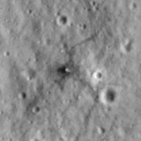
I have been experimenting with making improved images of Luna 17 and Lunokhod 1 for my revised moon atlas. These two images are each composites of eight LROC NAC images, enlarged and registered. The tracks are much more visible than in single images.
Phil
Luna 17
Lunokhod 1 -------------------- ... because the Solar System ain't gonna map itself.
Also to be found posting similar content on https://mastodon.social/@PhilStooke Maps for download (free PD: https://upload.wikimedia.org/wikipedia/comm...Cartography.pdf NOTE: everything created by me which I post on UMSF is considered to be in the public domain (NOT CC, public domain) |
||
|
|
|
||
|
Jul 26 2016, 09:24 PM
Post
#162
|
|||
|
Solar System Cartographer Group: Members Posts: 10160 Joined: 5-April 05 From: Canada Member No.: 227 |
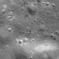
continuing the theme of improving LRO NAC images by combining several of them... here are two Surveyors:
Surveyor 1
Surveyor 3
Phil -------------------- ... because the Solar System ain't gonna map itself.
Also to be found posting similar content on https://mastodon.social/@PhilStooke Maps for download (free PD: https://upload.wikimedia.org/wikipedia/comm...Cartography.pdf NOTE: everything created by me which I post on UMSF is considered to be in the public domain (NOT CC, public domain) |
||
|
|
|
||
|
Mar 27 2018, 11:55 PM
Post
#163
|
|||
|
Solar System Cartographer Group: Members Posts: 10160 Joined: 5-April 05 From: Canada Member No.: 227 |
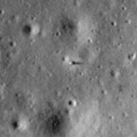
I had someone ask me about Surveyor 4 today, and the question comes up every now and then. Recently I tracked down a candidate for it, so here it is, with a bit of speculation.
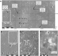
What should we be looking for? There are three obvious suggestions arising from three possible fates for the spacecraft. 1. Successful landing, but power or communications fail. We would see a lander like the other Surveyors, a lump casting a shadow in low sun images, probably surrounded by a bright patch where the rocket exhaust changes the surface - we see that for most landers. Also, a few hundred meters away we might see a dark spot, possibly resolved as a small crater, where the retro-rocket hit the surface after it was ejected. 2. The retrorocket fails to separate and the small thrusters used for landing fail or can't cope with the extra weight. A crash, showing up as a dark spot or small crater, but no separate retro-rocket impact. 3. The retrorocket separates, but one or more thrusters fail to ignite. The lander falls to the surface, with a retro-rocket impact nearby. What do we see? Here is a map showing the target and a zoom-in sequence leading to my candidate site:
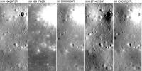
And here is a comparison of the five LROC-NAC images we have now:
My candidate is a dark spot which, in the best images may be resolved into a small crater. No bright halo, no lump casting a shadow. If it is Surveyor 4, it crashed. South of it at a distance of 200 m is a small dark spot which might be the retro-rocket. To me this suggests scenario 3. Phil -------------------- ... because the Solar System ain't gonna map itself.
Also to be found posting similar content on https://mastodon.social/@PhilStooke Maps for download (free PD: https://upload.wikimedia.org/wikipedia/comm...Cartography.pdf NOTE: everything created by me which I post on UMSF is considered to be in the public domain (NOT CC, public domain) |
||
|
|
|
||
|
Mar 28 2018, 12:22 AM
Post
#164
|
|
|
Merciless Robot Group: Admin Posts: 8783 Joined: 8-December 05 From: Los Angeles Member No.: 602 |
Looks compelling. Is it well within the intended landing ellipse? If there was a single thruster failure it may be offset from the projected course line.
-------------------- A few will take this knowledge and use this power of a dream realized as a force for change, an impetus for further discovery to make less ancient dreams real.
|
|
|
|
|
Mar 28 2018, 02:11 AM
Post
#165
|
|
|
Solar System Cartographer Group: Members Posts: 10160 Joined: 5-April 05 From: Canada Member No.: 227 |
Well within the ellipse which was about 30 km across, and in fact only about 1500 m from the location suggested by tracking.
Phil -------------------- ... because the Solar System ain't gonna map itself.
Also to be found posting similar content on https://mastodon.social/@PhilStooke Maps for download (free PD: https://upload.wikimedia.org/wikipedia/comm...Cartography.pdf NOTE: everything created by me which I post on UMSF is considered to be in the public domain (NOT CC, public domain) |
|
|
|
|

|
Lo-Fi Version | Time is now: 13th May 2024 - 09:27 AM |
|
RULES AND GUIDELINES Please read the Forum Rules and Guidelines before posting. IMAGE COPYRIGHT |
OPINIONS AND MODERATION Opinions expressed on UnmannedSpaceflight.com are those of the individual posters and do not necessarily reflect the opinions of UnmannedSpaceflight.com or The Planetary Society. The all-volunteer UnmannedSpaceflight.com moderation team is wholly independent of The Planetary Society. The Planetary Society has no influence over decisions made by the UnmannedSpaceflight.com moderators. |
SUPPORT THE FORUM Unmannedspaceflight.com is funded by the Planetary Society. Please consider supporting our work and many other projects by donating to the Society or becoming a member. |
|