Martian Cartography |

  |
Martian Cartography |
 Nov 3 2014, 01:16 AM Nov 3 2014, 01:16 AM
Post
#76
|
|
 Member  Group: Members Posts: 796 Joined: 27-February 08 From: Heart of Europe Member No.: 4057 |
I've just published my new topographic map of Mars in Mercator and polar stereographic projections.
Basic info is directly in the map. Map is available as 17 400 × 14 700 pix 78 MB jpeg via Flickr and as PDF with searchable text via Google Disc (106 MB!). As always for big PDFs, I recommend Sumatra viewer. Some other infos are on my blog but it's in Czech language. 
-------------------- |
 |
 
|
|
Nov 3 2014, 09:45 PM
Post
#77
|
|
 Senior Member Group: Members Posts: 1083 Joined: 19-February 05 From: Close to Meudon Observatory in France Member No.: 172 |
QUOTE (machi @ Nov 3 2014, 02:16 AM)  I've just published my new topographic map of Mars in Mercator and polar stereographic projections. Basic info is directly in the map. WOW ! WOW ! WOW ! What a MAP !!!!!!!!!!! Thanks so much Machi for sharing this impressive work of yours. Thank you so much again. With warmest regards, VM 
|
|
|
|
|
Nov 3 2014, 09:59 PM
Post
#78
|
|
 IMG to PNG GOD Group: Moderator Posts: 2250 Joined: 19-February 04 From: Near fire and ice Member No.: 38 |
Very impressive work. And Google translate apparently does a relatively good job translating the Czech text into English - I think I was able to understand/interpret all of translated text.
|
|
|
|
|
Nov 6 2014, 07:00 PM
Post
#79
|
|
|
Member Group: Members Posts: 796 Joined: 27-February 08 From: Heart of Europe Member No.: 4057 |
You're welcome!
QUOTE (Bjorn Jonsson @ Nov 3 2014, 10:59 PM) Very impressive work. And Google translate apparently does a relatively good job translating the Czech text into English - I think I was able to understand/interpret all of translated text. Google translate is very good for some languages in case of translating them to English and Czech is one of them ( I think  ). ).
-------------------- |
|
|
|
|
Jan 25 2015, 11:21 PM
Post
#80
|
||
|
Member Group: Members Posts: 796 Joined: 27-February 08 From: Heart of Europe Member No.: 4057 |
New version of my topographic map of Mars is now available.
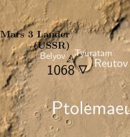
This "Easter egg" version has high resolution (~ 100 m/pix) parts around most of the landing sites. It works only as PDF so only this version is available. It has 116 MB and it needs good PDF viewer and computer with enough power (tested with Sumatra, FOXIT, SMART viewer and 8GB RAM). For an example here is part around Mars 3 landing site (located via HiView, longitude 202.01934056, latitude 45.0445105). EDIT: Files are now with correct English abbreviation for Soviet Union.
Attached thumbnail(s)
-------------------- |
|
|
|
|
|
|
Jan 26 2015, 10:48 AM
Post
#81
|
|
|
Senior Member Group: Members Posts: 1083 Joined: 19-February 05 From: Close to Meudon Observatory in France Member No.: 172 |
QUOTE (machi @ Jan 26 2015, 12:21 AM) .../... For an example here is part around Mars 3 landing site (located via HiView, longitude 202.01934056, latitude 45.0445105). Dear Machi, thanks so much !!!! Could you, please, be so kind to provide us also with the Mars 3 lander elevation ? Thanks so much in advance and with warmest regards, VM |
|
|
|
|
Jan 26 2015, 10:47 PM
Post
#82
|
|
|
Member Group: Members Posts: 796 Joined: 27-February 08 From: Heart of Europe Member No.: 4057 |
You're welcome!
Closest measurement from MOLA gives 1626 meters, HRSC DEM with better coverage but with lower precision gives ~1660 meters. Best guess based on published data 1655+/-30 meters. I suppose that I will add elevations for every identified lander in future version of the map. BTW, according to HiView coordinates of Beagle 2 are 90.4303226,11.5270253. These are slightly different than values which Doug Ellison extracted from Google Earth (90.4295E 11.5265N). This very small difference gives location error ~500 meters. But I have no idea how precise HiView is but based on my experience with other landers I suppose that Google is worse than HiView. -------------------- |
|
|
|
|
Jan 26 2015, 10:51 PM
Post
#83
|
|
|
Founder Group: Chairman Posts: 14432 Joined: 8-February 04 Member No.: 1 |
QUOTE (machi @ Jan 26 2015, 02:47 PM) BTW, according to HiView coordinates of Beagle 2 are 90.4303226,11.5270253. These are slightly different than values which Doug Ellison extracted from Google Earth (90.4295E 11.5265N). I pulled my values from HiView also...which is worrying. |
|
|
|
|
Jan 26 2015, 10:52 PM
Post
#84
|
|
|
Senior Member Group: Members Posts: 1083 Joined: 19-February 05 From: Close to Meudon Observatory in France Member No.: 172 |
QUOTE (machi @ Jan 26 2015, 11:47 PM) You're welcome! Closest measurement from MOLA gives 1626 meters, HRSC DEM with better coverage but with lower precision gives ~1660 meters. Best guess based on published data 1655+/-30 meters. I suppose that I will add elevations for every identified lander in future version of the map. BTW, according to HiView coordinates of Beagle 2 are 90.4303226,11.5270253. These are slightly different than values which Doug Ellison extracted from Google Earth (90.4295E 11.5265N). This very small difference gives location error ~500 meters. But I have no idea how precise HiView is but based on my experience with other landers I suppose that Google is worse than HiView. Thanks a lot Machi !
|
|
|
|
|
Jan 26 2015, 11:06 PM
Post
#85
|
|
|
Member Group: Members Posts: 796 Joined: 27-February 08 From: Heart of Europe Member No.: 4057 |
QUOTE (djellison @ Jan 26 2015, 11:51 PM) I pulled my values from HiView also...which is worrying. From which image? I've used ESP_037145_1915. I tried to extract location again in full resolution and it gives me 90.43036115568,11.52698736394 or 90.43036543916,11.52698314553. And I used wrong number in calculation so it's not error ~500 meters but only 50 meters. That's relatively negligible error. -------------------- |
|
|
|
|
Jan 27 2015, 10:42 AM
Post
#86
|
|
|
Member Group: Members Posts: 796 Joined: 27-February 08 From: Heart of Europe Member No.: 4057 |
My apology, as in previous version, I forgot Czech abbreviation of the Soviet Union in the map.
Now links leads to version with correct English abbreviation. And I've added small new feature - the map has hidden word "outpost" which facilitates the searching for landing sites. -------------------- |
|
|
|
|
Jan 15 2016, 02:12 AM
Post
#87
|
|
|
Member Group: Members Posts: 796 Joined: 27-February 08 From: Heart of Europe Member No.: 4057 |
Updated version of my map with all official names up to date 14.1.2016.
Full resolution image has ~110MB and PDF has 117MB. BTW, lowest place on Mars has finally official name - crater Badwater. 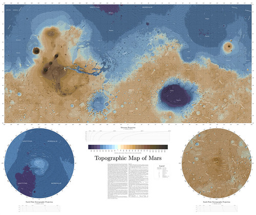
-------------------- |
|
|
|
|
Jan 20 2016, 09:04 AM
Post
#88
|
|
|
Senior Member Group: Members Posts: 1083 Joined: 19-February 05 From: Close to Meudon Observatory in France Member No.: 172 |
[quote name='machi' date='Jan 15 2016, 03:12 AM' post='229048']
Updated version of my map with all official names up to date 14.1.2016. What an INCREDIBLE work !!!!! Thanks a lot Machi ! |
|
|
|
|
Apr 12 2016, 01:52 AM
Post
#89
|
|
|
Senior Member Group: Members Posts: 1043 Joined: 17-February 09 Member No.: 4605 |
Interesting to match Machi's stunning topographical map with the just completed Gravity and crustal thickness maps.
http://mars.nasa.gov/mro/news/whatsnew/ind...amp;NewsID=1899 |
|
|
|
|
Dec 8 2016, 11:17 AM
Post
#90
|
|
|
Newbie Group: Members Posts: 1 Joined: 6-December 16 Member No.: 8084 |
what a nice photos

-------------------- Graduated from Soran University with First Class Degree with Honours in Computer Science.
|
|
|
|
|

|
Lo-Fi Version | Time is now: 25th April 2024 - 05:24 PM |
|
RULES AND GUIDELINES Please read the Forum Rules and Guidelines before posting. IMAGE COPYRIGHT |
OPINIONS AND MODERATION Opinions expressed on UnmannedSpaceflight.com are those of the individual posters and do not necessarily reflect the opinions of UnmannedSpaceflight.com or The Planetary Society. The all-volunteer UnmannedSpaceflight.com moderation team is wholly independent of The Planetary Society. The Planetary Society has no influence over decisions made by the UnmannedSpaceflight.com moderators. |
SUPPORT THE FORUM Unmannedspaceflight.com is funded by the Planetary Society. Please consider supporting our work and many other projects by donating to the Society or becoming a member. |
|