Journey to Mt Sharp - Part 4: Beyond the Kimberley, Sol 634 [May 19, '14] to 706 [Jul 31, '14] |

  |
Journey to Mt Sharp - Part 4: Beyond the Kimberley, Sol 634 [May 19, '14] to 706 [Jul 31, '14] |
 May 21 2014, 12:19 PM May 21 2014, 12:19 PM
Post
#16
|
||
 Senior Member  Group: Members Posts: 1465 Joined: 9-February 04 From: Columbus OH USA Member No.: 13 |
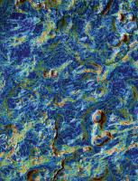
A little different view of the terrain, with the local slope color-coded:
dark blue: 0-5% light blue: 5-10% green: 10-15% orange: 15-20% red: >20% -------------------- |
|
 |
 
|
|
|
May 21 2014, 02:33 PM
Post
#17
|
||
|
Solar System Cartographer Group: Members Posts: 10145 Joined: 5-April 05 From: Canada Member No.: 227 |
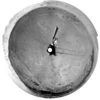
Here is Jan's panorama in circular form, showing a nice easy driving area. As jmknapp noted, it's going to get a lot more rugged pretty soon.
Phil
-------------------- ... because the Solar System ain't gonna map itself.
Also to be found posting similar content on https://mastodon.social/@PhilStooke NOTE: everything created by me which I post on UMSF is considered to be in the public domain (NOT CC, public domain) |
|
|
|
|
|
|
May 21 2014, 06:37 PM
Post
#18
|
|
|
Senior Member Group: Members Posts: 1074 Joined: 21-September 07 From: Québec, Canada Member No.: 3908 |
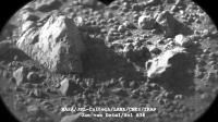
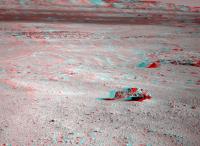
The large rock in the middle of this image seems a bit out of place. From this distance, its surface texture reminds me of the pits on a meteorite. Since we're moving more or less in that direction, maybe we'll get a better view later.
|
|
|
|
|
May 21 2014, 06:53 PM
Post
#19
|
|
|
Member Group: Members Posts: 201 Joined: 16-December 13 Member No.: 7067 |
Sol 636 images are coming down, here is the beginning of full pan, looking south and panning right
http://imgur.com/a/WQQox#0 Stretched version - far from perfect since I'm struggling to correct the tilt (straightforward with one image, less so with a pair), but it does bring out features I wouldn't have noticed. http://imgur.com/a/S2w8R#0 |
|
|
|
|
May 21 2014, 07:26 PM
Post
#20
|
|
|
Solar System Cartographer Group: Members Posts: 10145 Joined: 5-April 05 From: Canada Member No.: 227 |
That big rock does look enticing! I think we'll go pretty close to it.
Phil -------------------- ... because the Solar System ain't gonna map itself.
Also to be found posting similar content on https://mastodon.social/@PhilStooke NOTE: everything created by me which I post on UMSF is considered to be in the public domain (NOT CC, public domain) |
|
|
|
|
May 22 2014, 12:39 AM
Post
#21
|
|
 Administrator Group: Admin Posts: 5172 Joined: 4-August 05 From: Pasadena, CA, USA, Earth Member No.: 454 |
Random note: a few weeks ago I learned that the DAN pulsing neutron generator had a limited lifetime. Today someone pointed out the arithmetic to me: the warranted lifetime for DAN was 3 years after launch, or until December 2013. So any day that DAN's active mode continues to work is a blessing. Similar units on Earth have lasted anywhere from 2 to 6 years, so it could continue to work for a while, but may not. It should function forever in passive mode, and still do great science searching for anomalous levels of hydrogen in the subsurface, but once the neutron generator dies (and apparently once it goes, it goes quickly) it will no longer be able to suss out the layered structure of the subsurface.
-------------------- My website - My Patreon - @elakdawalla on Twitter - Please support unmannedspaceflight.com by donating here.
|
|
|
|
|
May 22 2014, 04:08 PM
Post
#22
|
|
|
Member Group: Members Posts: 201 Joined: 16-December 13 Member No.: 7067 |
Finished the Sol 636 anaglyph pan albums with the new images at the beginning http://imgur.com/a/WQQox
And stretched http://imgur.com/a/S2w8R 12 drive images - first 6 are disjointed pairs, last 6 are continuous http://i.imgur.com/36Brv7K.gif So here are the anaglyph versions split into the 3 pairs and last bit (included all for the sake of completeness) 1st -2nd - 3rd Interesting part Sol 637 anaglyph album so far http://imgur.com/a/NBy3Z#0 And 637 stretched http://imgur.com/a/zPAc3#0 |
|
|
|
|
May 22 2014, 06:41 PM
Post
#23
|
||
|
Senior Member Group: Members Posts: 2817 Joined: 22-April 05 From: Ridderkerk, Netherlands Member No.: 353 |
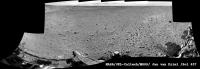
Chemcam panorama taken on Sol 636.
Jan van Driel
|
|
|
|
|
|
|
May 22 2014, 07:27 PM
Post
#24
|
|
|
Solar System Cartographer Group: Members Posts: 10145 Joined: 5-April 05 From: Canada Member No.: 227 |
Another drive on sol 637, and it looks from the Hazcam as if we are just uphill from that big rock. Maybe a weekend target?
Phil -------------------- ... because the Solar System ain't gonna map itself.
Also to be found posting similar content on https://mastodon.social/@PhilStooke NOTE: everything created by me which I post on UMSF is considered to be in the public domain (NOT CC, public domain) |
|
|
|
|
May 22 2014, 07:27 PM
Post
#25
|
||
|
Senior Member Group: Members Posts: 2817 Joined: 22-April 05 From: Ridderkerk, Netherlands Member No.: 353 |
Navcam NL B view on Sol 636.
Jan van Driel
|
|
|
|
|
|
|
May 23 2014, 07:41 AM
Post
#26
|
||
|
Senior Member Group: Members Posts: 2817 Joined: 22-April 05 From: Ridderkerk, Netherlands Member No.: 353 |
The Mastcam L view on Sol 636.
Jan van Driel
|
|
|
|
|
|
|
May 23 2014, 08:36 AM
Post
#27
|
||
|
Senior Member Group: Members Posts: 2817 Joined: 22-April 05 From: Ridderkerk, Netherlands Member No.: 353 |
The Navcam L view on Sol 637.
Jan van Driel
|
|
|
|
|
|
|
May 23 2014, 10:48 AM
Post
#28
|
||
|
Senior Member Group: Members Posts: 1465 Joined: 9-February 04 From: Columbus OH USA Member No.: 13 |
Anaglyph looking south:
-------------------- |
|
|
|
|
|
|
May 23 2014, 02:58 PM
Post
#29
|
|
|
Member Group: Members Posts: 910 Joined: 4-September 06 From: Boston Member No.: 1102 |
Nice!! Joe, what do you estimate the size of that rock/meteorite? Fred, we need someone standing next to it!
-------------------- |
|
|
|
|
May 23 2014, 03:11 PM
Post
#30
|
||
|
Senior Member Group: Members Posts: 2817 Joined: 22-April 05 From: Ridderkerk, Netherlands Member No.: 353 |
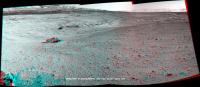
Part of the Sol 637 Navcam panorama in Stereo.
Jan van Driel
|
|
|
|
|
|
|

|
Lo-Fi Version | Time is now: 18th April 2024 - 02:58 PM |
|
RULES AND GUIDELINES Please read the Forum Rules and Guidelines before posting. IMAGE COPYRIGHT |
OPINIONS AND MODERATION Opinions expressed on UnmannedSpaceflight.com are those of the individual posters and do not necessarily reflect the opinions of UnmannedSpaceflight.com or The Planetary Society. The all-volunteer UnmannedSpaceflight.com moderation team is wholly independent of The Planetary Society. The Planetary Society has no influence over decisions made by the UnmannedSpaceflight.com moderators. |
SUPPORT THE FORUM Unmannedspaceflight.com is funded by the Planetary Society. Please consider supporting our work and many other projects by donating to the Society or becoming a member. |
|