MSL Route Map |

  |
MSL Route Map |
 Sep 26 2012, 04:24 PM Sep 26 2012, 04:24 PM
Post
#61
|
||
|
Solar System Cartographer  Group: Members Posts: 10227 Joined: 5-April 05 From: Canada Member No.: 227 |
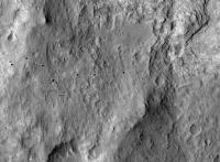
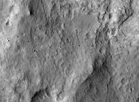
As it turned out the last map didn't need much revising - just a tiny adjustment, added in this one (previous one not edited). As for sol 50 - must be pretty close to here.
EDIT: sol 50 location replaced with a better match to images after making a hasty panorama - drive was the longest to date. Phil
-------------------- ... because the Solar System ain't gonna map itself.
Also to be found posting similar content on https://mastodon.social/@PhilStooke Maps for download (free PDF: https://upload.wikimedia.org/wikipedia/comm...Cartography.pdf NOTE: everything created by me which I post on UMSF is considered to be in the public domain (NOT CC, public domain) |
|
 |
 
|
|
|
Sep 27 2012, 07:24 PM
Post
#62
|
||
|
Solar System Cartographer Group: Members Posts: 10227 Joined: 5-April 05 From: Canada Member No.: 227 |
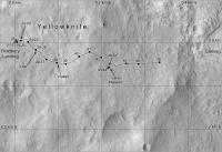
Nothing on sol 51 yet, but as we have some new feature names I will put this up - with 100 m grid for scale.
Phil
-------------------- ... because the Solar System ain't gonna map itself.
Also to be found posting similar content on https://mastodon.social/@PhilStooke Maps for download (free PDF: https://upload.wikimedia.org/wikipedia/comm...Cartography.pdf NOTE: everything created by me which I post on UMSF is considered to be in the public domain (NOT CC, public domain) |
|
|
|
|
|
|
Sep 27 2012, 08:06 PM
Post
#63
|
|
 Junior Member Group: Members Posts: 21 Joined: 21-August 12 From: the Netherlands Member No.: 6599 |
New V2.0 ...
Full Gale Crater basemap for Google Earth mid-res. improvement for Google's build-in low-res full crater map .  Updated: 30 sept.  goto__Google_Earth_KML___.htm ( 1.71K )
Number of downloads: 1095
goto__Google_Earth_KML___.htm ( 1.71K )
Number of downloads: 1095, |
|
|
|
|
Sep 28 2012, 06:05 PM
Post
#64
|
||
|
Solar System Cartographer Group: Members Posts: 10227 Joined: 5-April 05 From: Canada Member No.: 227 |
update for sol 52, a fairly well constrained position.
Phil
-------------------- ... because the Solar System ain't gonna map itself.
Also to be found posting similar content on https://mastodon.social/@PhilStooke Maps for download (free PDF: https://upload.wikimedia.org/wikipedia/comm...Cartography.pdf NOTE: everything created by me which I post on UMSF is considered to be in the public domain (NOT CC, public domain) |
|
|
|
|
|
|
Oct 1 2012, 01:39 PM
Post
#65
|
||
|
Solar System Cartographer Group: Members Posts: 10227 Joined: 5-April 05 From: Canada Member No.: 227 |
Updated map for sol 54. I'm hoping to get an outcrop name soon.
(PS what you're seeing here is work in progress for Vol. 2 of my Mars atlas. I'm keeping MSL and recent Opportunity up to date while filling in the earlier things.) Phil
-------------------- ... because the Solar System ain't gonna map itself.
Also to be found posting similar content on https://mastodon.social/@PhilStooke Maps for download (free PDF: https://upload.wikimedia.org/wikipedia/comm...Cartography.pdf NOTE: everything created by me which I post on UMSF is considered to be in the public domain (NOT CC, public domain) |
|
|
|
|
|
|
Oct 1 2012, 06:40 PM
Post
#66
|
||
|
Solar System Cartographer Group: Members Posts: 10227 Joined: 5-April 05 From: Canada Member No.: 227 |
Sol 55 update. The path between sol 54 and sol 55 is partly conjectural at this stage, but later navcams may help refine it.
Phil
-------------------- ... because the Solar System ain't gonna map itself.
Also to be found posting similar content on https://mastodon.social/@PhilStooke Maps for download (free PDF: https://upload.wikimedia.org/wikipedia/comm...Cartography.pdf NOTE: everything created by me which I post on UMSF is considered to be in the public domain (NOT CC, public domain) |
|
|
|
|
|
|
Oct 2 2012, 03:28 PM
Post
#67
|
|
 Senior Member Group: Members Posts: 1619 Joined: 12-February 06 From: Bergerac - FR Member No.: 678 |
An estimation of the total distance made by the rover ?
-------------------- |
|
|
|
|
Oct 2 2012, 03:49 PM
Post
#68
|
|
|
Solar System Cartographer Group: Members Posts: 10227 Joined: 5-April 05 From: Canada Member No.: 227 |
if you compare my current map with the version with a grid that I post occasionally, you will see we are just short of 400 m east of the landing site and about 40 m south of it. I have not added up the odometry for a total distance but it's probably in the JPL releases.
Phil -------------------- ... because the Solar System ain't gonna map itself.
Also to be found posting similar content on https://mastodon.social/@PhilStooke Maps for download (free PDF: https://upload.wikimedia.org/wikipedia/comm...Cartography.pdf NOTE: everything created by me which I post on UMSF is considered to be in the public domain (NOT CC, public domain) |
|
|
|
|
Oct 2 2012, 07:30 PM
Post
#69
|
||
|
Solar System Cartographer Group: Members Posts: 10227 Joined: 5-April 05 From: Canada Member No.: 227 |
Sol 56, small update. We will probably be here for a while now.
Phil
-------------------- ... because the Solar System ain't gonna map itself.
Also to be found posting similar content on https://mastodon.social/@PhilStooke Maps for download (free PDF: https://upload.wikimedia.org/wikipedia/comm...Cartography.pdf NOTE: everything created by me which I post on UMSF is considered to be in the public domain (NOT CC, public domain) |
|
|
|
|
|
|
Oct 4 2012, 09:49 PM
Post
#70
|
||
|
Solar System Cartographer Group: Members Posts: 10227 Joined: 5-April 05 From: Canada Member No.: 227 |
A corrected copy of the map - I was off in my position for the Bathurst Inlet stop.
Phil
-------------------- ... because the Solar System ain't gonna map itself.
Also to be found posting similar content on https://mastodon.social/@PhilStooke Maps for download (free PDF: https://upload.wikimedia.org/wikipedia/comm...Cartography.pdf NOTE: everything created by me which I post on UMSF is considered to be in the public domain (NOT CC, public domain) |
|
|
|
|
|
|
Oct 5 2012, 03:01 AM
Post
#71
|
||
|
Newbie Group: Members Posts: 14 Joined: 9-November 09 Member No.: 5032 |
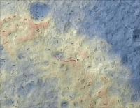
I was hoping to find a hypsographic map of the landing site but could not find any. So I made one using a HiRISE DEM and ArcGIS.
The orange tones denote higher elevations, yellow is intermediate elevations, and blue marks lower elevations. I could only find a KML on this thread up to Sol 42; if someone directs me to a newer KML, I can update this. Enjoy, Michael eclipse-maps.com
|
|
|
|
|
|
|
Oct 5 2012, 03:35 AM
Post
#72
|
|
 Member Group: Members Posts: 447 Joined: 1-July 05 From: New York City Member No.: 424 |
That's lovely. Anything further you make along these lines showing more of Gale Crater and MSL's expected exploration paths will be loudly appreciated, by me at least, and I suspect by others as well.
|
|
|
|
|
Oct 5 2012, 05:09 AM
Post
#73
|
|
|
Member Group: Members Posts: 166 Joined: 20-September 05 From: North Texas Member No.: 503 |
QUOTE (Michael Zeiler @ Oct 5 2012, 03:01 AM)  The orange tones denote higher elevations, yellow is intermediate elevations, and blue marks lower elevations. Thanks for the great map. I was just noticing the steep dropoffs in the North Central and the Northeast portions of the map. Those drops are 10 meters or more in a fairly short distance. I'm thinking those slopes must be over 20 degrees. Glad we didn't land on those slopes. |
|
|
|
|
Oct 5 2012, 05:28 AM
Post
#74
|
|
|
Member Group: Members Posts: 447 Joined: 1-July 05 From: New York City Member No.: 424 |
QUOTE (Ant103 @ Oct 2 2012, 11:28 AM) An estimation of the total distance made by the rover ? At today's press conference, one of the engineers said that total odometry was about 80 meters more than the "as the crow flies" distance, or about 480 meters total odometry. |
|
|
|
|
Oct 5 2012, 06:38 AM
Post
#75
|
|
 Senior Member Group: Members Posts: 1729 Joined: 3-August 06 From: 43° 35' 53" N 1° 26' 35" E Member No.: 1004 |
the caption of one of images released for yesterday's teleconf said 484 m total
|
|
|
|
|

|
Lo-Fi Version | Time is now: 25th September 2024 - 04:14 PM |
|
RULES AND GUIDELINES Please read the Forum Rules and Guidelines before posting. IMAGE COPYRIGHT |
OPINIONS AND MODERATION Opinions expressed on UnmannedSpaceflight.com are those of the individual posters and do not necessarily reflect the opinions of UnmannedSpaceflight.com or The Planetary Society. The all-volunteer UnmannedSpaceflight.com moderation team is wholly independent of The Planetary Society. The Planetary Society has no influence over decisions made by the UnmannedSpaceflight.com moderators. |
SUPPORT THE FORUM Unmannedspaceflight.com is funded by the Planetary Society. Please consider supporting our work and many other projects by donating to the Society or becoming a member. |
|