Geomorphology of Gale Crater, Rock on! |

  |
Geomorphology of Gale Crater, Rock on! |
 Oct 6 2012, 09:30 AM Oct 6 2012, 09:30 AM
Post
#46
|
|
|
Senior Member  Group: Members Posts: 3516 Joined: 4-November 05 From: North Wales Member No.: 542 |
I am particularly intrigued by the enclosed depression on the right of Peter's contoured elevation map:
http://petergrindrod.net/wp-content/upload...g-site-topo.png The depression coincides exactly with the outer margin of the high thermal inertia fan (HTIF). I'm also curious about where the substantial quantity of flowing water that formed the fan was actually flowing to. I'm toying with the idea that it spread out and froze in place, forming over time a substantial ice deposit. I don't know the proper name for such a thing so for now I'm calling it an 'ice snout'. Maybe all of the HTIF is a marker for the former extent of the ice snout. Sublimation of volatiles is widely invoked to explain hollows. Here we appear to have a hollow and a ready supply of volatile material at some time in the past. There are what look like polygonal markings on the bottom of the depression. Where have we seen that before? I can't wait to get down there. |
 |
 
|
|
Oct 6 2012, 07:26 PM
Post
#47
|
|
|
Junior Member Group: Members Posts: 85 Joined: 5-September 12 Member No.: 6635 |
QUOTE (ngunn @ Oct 6 2012, 10:30 AM)  I am particularly intrigued by the enclosed depression on the right of Peter's contoured elevation map: http://petergrindrod.net/wp-content/upload...g-site-topo.png Sublimation of volatiles is widely invoked to explain hollows. Hmm - The peculiarity of the craterlet density in the unit covering the area SE of Glenelg has been mentioned earlier in this thread. Notice the complete saturation and fairly uniform size of these little hollows in the eastern part of this unit. Could this unit be a remnant of a sediment saturated outflow that was deposited more or less all at once ?? Assuming the slurry is near the triple point pressure of H20, small variations in conditions within the slurry could result in explosive boiling one place while a few meters away the slurry is still liquid. At the same time it is rapidly freezing on its surface so that the little craterlets that are left behind as the vapor bubble breaks the surface are flash frozen in place. IF the slurry is thick enough the craterlets might still be discernible as the remaining H20 slowly sublimates away and the remaining dry deposit settles. (this is somewhat consistent with your "ice snout" idea) |
|
|
|
|
Oct 6 2012, 08:53 PM
Post
#48
|
|
|
Senior Member Group: Members Posts: 3516 Joined: 4-November 05 From: North Wales Member No.: 542 |
It's fun to look at those craterlets and imagine the kind of one-off event you describe, although I'm having difficulty with the idea of individual bubbles of the required size. There's a long timespan and a wide range for climate parameters (including, crucially, the total mass of the atmosphere) available as possible conditions for the processes that formed this landcape so it's open season for imaginative suggestions, I think.
EDIT: I've looked again and the crater sizes go right down there: too small for impacts under any kind of atmosphere. Interesting. |
|
|
|
|
Oct 6 2012, 09:08 PM
Post
#49
|
|
|
Junior Member Group: Members Posts: 85 Joined: 5-September 12 Member No.: 6635 |
I agree. It is great fun to try to imagine processes that are beyond our earth biased experiences.
Over on the "Temperature and Pressure" topic I've been making trouble with the goal of perhaps gaining some insight into the subject of this thread. It is hard to imagine how water might behave around the triple point on a large scale in a low g environment since it is beyond our earthly experience. But small changes can have major phase consequences. In addition, in the low Martian gravity I would imagine the bubbles would grow larger than on earth .... true? |
|
|
|
|
Oct 6 2012, 09:30 PM
Post
#50
|
|
|
Junior Member Group: Members Posts: 85 Joined: 5-September 12 Member No.: 6635 |
Also - as you queried - Where is the water flowing to
I've always been struck by the apparent contradiction between the ubiquitous, planet-wide evidence of flowing liquids on Mars but the almost complete lack of any strong evidence of any standing liquids on Mars at any time in Martian history. Mars is trying to tell us something. |
|
|
|
|
Oct 6 2012, 10:12 PM
Post
#51
|
|
|
Senior Member Group: Members Posts: 3516 Joined: 4-November 05 From: North Wales Member No.: 542 |
QUOTE (Eyesonmars @ Oct 6 2012, 10:30 PM) the almost complete lack of any strong evidence of any standing liquids on Mars at any time in Martian history I don't think that's quite true. I'm fairly persuaded by the the northern ocean shorelines. But you're right. It is the nature of water on Mars to do its deed and disappear, into space no doubt but also under ground (perhaps not very far). |
|
|
|
|
Oct 7 2012, 03:22 AM
Post
#52
|
|
|
Senior Member Group: Members Posts: 1045 Joined: 17-February 09 Member No.: 4605 |
QUOTE (Eyesonmars @ Oct 6 2012, 09:08 PM) It is hard to imagine how water might behave around the triple point on a large scale in a low g environment since it is beyond our earthly experience. The evidence of long lasting fluvial activity around and in gale would seem to indicate that the pressure and temperature 3 to 4 billion years ago was significantly different to today. From the apparent inverted channels it seems that most recently Gale has gone through a significant deflationary cycle. The topography during the fluvial period may have been quite different to today and some of the effects such as the hollows could be attributable to differential erosion. The low/high thermal inertia units look like part of the same fan. An alluvial fan that transitioned to an alluvial fan delta when it encountered standing water? Stranger things have happened. |
|
|
|
|
Oct 7 2012, 07:40 AM
Post
#53
|
|
|
Senior Member Group: Members Posts: 3516 Joined: 4-November 05 From: North Wales Member No.: 542 |
QUOTE (serpens @ Oct 7 2012, 04:22 AM) The low/high thermal inertia units look like part of the same fan. An alluvial fan that transitioned to an alluvial fan delta when it encountered standing water? Stranger things have happened. Another interesting idea.  Does the LTIF/HTIF boundary follow a topgraphic contour, and if so, how big an area does that contour enclose? We will need a more extensive map to answer such questions. Does the LTIF/HTIF boundary follow a topgraphic contour, and if so, how big an area does that contour enclose? We will need a more extensive map to answer such questions.Here's a variation on my 'ice snout' suggestion. In warmer conditions the fan could have terminated in a 'salt snout' rather than an icy one. Flood the whole area at a later epoch and the salt redissolves - another way to form a hollow perhaps. (Would that count as differential erosion?) |
|
|
|
|
Oct 7 2012, 08:59 AM
Post
#54
|
|
|
Member Group: Members Posts: 293 Joined: 22-September 08 From: Spain Member No.: 4350 |
Mmh, is the assumed order of events: 1) the last sulfate layers of Mt Sharp were deposited; 2) Mt Sharp was eroded; 3) The fan was deposited on the new floor of Gale Crater?
In that case the fan would be from an age long after conditions were suitable for the standing acidic water that created Mt Sharp layers, and after a dry period in which all the erosion happened. Maybe the atmosphere was gone already, and they were just seasonal flash streams from molten ice that then sublimated away. |
|
|
|
|
Oct 7 2012, 02:00 PM
Post
#55
|
|
|
Senior Member Group: Members Posts: 1045 Joined: 17-February 09 Member No.: 4605 |
The filled then excavated crater hypothesis seems a logical explanation for the reasonably thick clay layer exposed at the base of Mount Sharp (neutral pH), beneath the sulphates. The clay layer could be a lacustrine deposition and if so then the fan would possibly have formed at that time, been covered and then excavated. Curiosity will probably be able to clarify with ground truth.
|
|
|
|
|
Oct 7 2012, 09:30 PM
Post
#56
|
|
|
Junior Member Group: Members Posts: 59 Joined: 12-March 10 From: Austin, TX Member No.: 5262 |
QUOTE (Eyesonmars @ Oct 6 2012, 04:30 PM) Also - as you queried - Where is the water flowing to That's the question I wanted to ask on this forum also. I'm interested in identifying the lowest point in Gale between here and where we expect to head up to Sharp for two reasons: 1. It may be where some water went as some time in the geological history of Gale and 2. It could/should be the point where we'd expect to find the oldest layers in the stratigraphy of Gale/Sharp. I didn't identify any mention of such a location in the Anderson paper (not that that means it isn't there). It would seem orienting to me to know where that is and what's already know about what's there (for orbital images, spectroscopic studies, etc.) |
|
|
|
|
Oct 7 2012, 09:51 PM
Post
#57
|
|
|
Senior Member Group: Members Posts: 3516 Joined: 4-November 05 From: North Wales Member No.: 542 |
There are contours derived from CTX by Peter Grindrod here:
http://petergrindrod.net/wp-content/upload...CTX-context.png That shows we are right on the edge of an enclosed depression. I don't know whether it's the deepest in the whole crater, but if water flowed over the alluvial fan today I think it would have nowhere to go except into the hollow we are overlooking now. |
|
|
|
|
Oct 8 2012, 04:16 PM
Post
#58
|
||
|
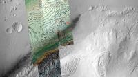
Junior Member Group: Members Posts: 59 Joined: 18-July 07 From: London, UK Member No.: 2873 |
After a few requests, I've made some base maps of Gale and the Bradbury Landing site at a few different zoom levels.
They're all linked over here, with a bit of an accompanying explanation. A scaled down example of what's there:
Hopefully they might be of some use in discussions like those above. Pete |
|
|
|
|
|
|
Oct 8 2012, 07:10 PM
Post
#59
|
|
|
Senior Member Group: Members Posts: 3516 Joined: 4-November 05 From: North Wales Member No.: 542 |
Extremely helpful and much, much appreciated.
|
|
|
|
|
Oct 9 2012, 01:23 AM
Post
#60
|
|
|
Junior Member Group: Members Posts: 59 Joined: 12-March 10 From: Austin, TX Member No.: 5262 |
Thanks Pete, very helpful indeed. One of the things I keep wondering about is the much bigger inflow channel (and alluvial fan?) coming in from the southwest crater rim. These maps show there is a very big "sink" at the end of the "fan" (roughly due west of the peak of Sharp), much bigger than the one at Glenelg. It would seem that deposits from that channel would not come into play at Glenelg by my reading, but I'm not sure of that. If the SW channel is the older one, I guess it's possible that it's deposits did reach Glenelg.
|
|
|
|
|

|
Lo-Fi Version | Time is now: 3rd June 2024 - 10:57 PM |
|
RULES AND GUIDELINES Please read the Forum Rules and Guidelines before posting. IMAGE COPYRIGHT |
OPINIONS AND MODERATION Opinions expressed on UnmannedSpaceflight.com are those of the individual posters and do not necessarily reflect the opinions of UnmannedSpaceflight.com or The Planetary Society. The all-volunteer UnmannedSpaceflight.com moderation team is wholly independent of The Planetary Society. The Planetary Society has no influence over decisions made by the UnmannedSpaceflight.com moderators. |
SUPPORT THE FORUM Unmannedspaceflight.com is funded by the Planetary Society. Please consider supporting our work and many other projects by donating to the Society or becoming a member. |
|