Journey to Mt Sharp - Part 2: Darwin to Cooperstown, Sol 402 [Sep23,'13] to Sol452 [Nov14,'13] NB: Warm Reset |

  |
Journey to Mt Sharp - Part 2: Darwin to Cooperstown, Sol 402 [Sep23,'13] to Sol452 [Nov14,'13] NB: Warm Reset |
 Sep 27 2013, 08:37 PM Sep 27 2013, 08:37 PM
Post
#31
|
||
 Member  Group: Members Posts: 219 Joined: 14-November 11 From: Washington, DC Member No.: 6237 |
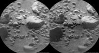
These two Sol 406 ChemCam images (flatfield corrected) provide both before-after and stereo views.
Crosseye:
|
|
 |
 
|
|
|
Sep 27 2013, 09:21 PM
Post
#32
|
|
|
Solar System Cartographer Group: Members Posts: 10153 Joined: 5-April 05 From: Canada Member No.: 227 |
Very nice!
And now a great new map from Fred Calef (I assume) at JPL, with lots of new names on it: http://mars.jpl.nasa.gov/msl/images/MSL_Tr...ol0406-full.jpg Phil -------------------- ... because the Solar System ain't gonna map itself.
Also to be found posting similar content on https://mastodon.social/@PhilStooke Maps for download (free PD: https://upload.wikimedia.org/wikipedia/comm...Cartography.pdf NOTE: everything created by me which I post on UMSF is considered to be in the public domain (NOT CC, public domain) |
|
|
|
|
Sep 28 2013, 11:35 AM
Post
#33
|
|
|
Newbie Group: Members Posts: 7 Joined: 21-August 12 Member No.: 6598 |
Great map. Is there a map that shows the path to-date but also includes the anticipated destination? It would be nice to be able to put into context where we striving to get to next. I know this wouldn't be exact and that the path is fluid but surely we have a rough idea where we are trying to get to?
Thanks. |
|
|
|
|
Sep 28 2013, 01:18 PM
Post
#34
|
|
|
Solar System Cartographer Group: Members Posts: 10153 Joined: 5-April 05 From: Canada Member No.: 227 |
http://mars.jpl.nasa.gov/msl/multimedia/images/?ImageID=5533
Just browse the Curiosity press release page! Phil -------------------- ... because the Solar System ain't gonna map itself.
Also to be found posting similar content on https://mastodon.social/@PhilStooke Maps for download (free PD: https://upload.wikimedia.org/wikipedia/comm...Cartography.pdf NOTE: everything created by me which I post on UMSF is considered to be in the public domain (NOT CC, public domain) |
|
|
|
|
Sep 28 2013, 01:40 PM
Post
#35
|
|
 Senior Member Group: Members Posts: 1084 Joined: 19-February 05 From: Close to Meudon Observatory in France Member No.: 172 |
QUOTE (Phil Stooke @ Sep 27 2013, 11:21 PM)  And now a great new map from Fred Calef (I assume) at JPL, with lots of new names on it. Phil Thanks Phil. ...and "bye-bye" for good to MSL's backshell and parachute imaging. A real missed opportunity for good outreach pics and for our Mars exploration pic log (  also as a French taxpayer to this mission) also as a French taxpayer to this mission)
|
|
|
|
|
Sep 28 2013, 02:46 PM
Post
#36
|
|
 Senior Member Group: Members Posts: 4246 Joined: 17-January 05 Member No.: 152 |
Viking: we had 360 navcam pans all through the potential hardware viewing zone, and if we had a clear line of sight to the parachute I'm sure it would've been obvious in navcam. So that suggests it would've meant driving some distance off our route to see the hardware. Of course you could still argue that that should've been done, but that's another argument...
QUOTE (Greenish @ Sep 27 2013, 09:37 PM) These two Sol 406 ChemCam images (flatfield corrected) provide both before-after and stereo views. Nice before and after, but no stereo I'd say - the rover would need to move between frames for real stereo (which actually happened once with chemcam). |
|
|
|
|
Sep 28 2013, 04:02 PM
Post
#37
|
|
|
Founder Group: Chairman Posts: 14432 Joined: 8-February 04 Member No.: 1 |
QUOTE (vikingmars @ Sep 28 2013, 06:40 AM) A real missed opportunity... It would have taken weeks to get to a location worthwhile for imaging that hardware. Weeks. Split the cost of the mission into Sols. Do the math. The lost opportunity would not be getting to Mt Sharp before the end of the prime mission. |
|
|
|
|
Sep 29 2013, 08:49 PM
Post
#38
|
|
 Member Group: Members Posts: 691 Joined: 21-December 07 From: Clatskanie, Oregon Member No.: 3988 |
Also the hardware may still be able to be seen at a distance from the flanks of Mount Sharp as we drive up.

|
|
|
|
|
Sep 30 2013, 02:05 PM
Post
#39
|
|
 Senior Member Group: Members Posts: 1465 Joined: 9-February 04 From: Columbus OH USA Member No.: 13 |
Long spell now without new images--three sols. Any particular reason? The USGS blog doesn't have a recent entry.
-------------------- |
|
|
|
|
Sep 30 2013, 02:37 PM
Post
#40
|
|
|
Senior Member Group: Members Posts: 2346 Joined: 7-December 12 Member No.: 6780 |
Restricted sols, Monday.
|
|
|
|
|
Sep 30 2013, 02:40 PM
Post
#41
|
|
 Senior Member Group: Members Posts: 2428 Joined: 30-January 13 From: Penang, Malaysia. Member No.: 6853 |
QUOTE (jmknapp @ Sep 30 2013, 10:05 PM) Long spell now without new images--three sols. Any particular reason? The USGS blog doesn't have a recent entry. I would speculate a combination of weekend and a possible tweak to the flight software to negate some of the issues that prematurely terminated the sol 404 drive? Almost certainly not time for a full fix, but maybe a relaxation of the 'conservative settings' that were in force? Just a thought |
|
|
|
|
Sep 30 2013, 07:01 PM
Post
#42
|
||
 Member Group: Members Posts: 334 Joined: 11-December 12 From: The home of Corby Crater (Corby-England) Member No.: 6783 |
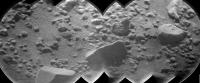
A sol 406 ChemCam pano showing 7(?) laser shots.
Tootin-Rootin Shootin! 
Attached thumbnail(s)
|
|
|
|
|
|
|
Sep 30 2013, 07:22 PM
Post
#43
|
|
|
Senior Member Group: Members Posts: 1465 Joined: 9-February 04 From: Columbus OH USA Member No.: 13 |
And, lo, 652 images from the last three sols were just released, including maybe a 3.5-hour drive on sol 409.
-------------------- |
|
|
|
|
Sep 30 2013, 07:45 PM
Post
#44
|
||
|
Solar System Cartographer Group: Members Posts: 10153 Joined: 5-April 05 From: Canada Member No.: 227 |
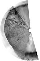
And maybe 60 or 70 m due south (or even slightly east of south). Here's a very rough partial pan in circular form.
Phil
-------------------- ... because the Solar System ain't gonna map itself.
Also to be found posting similar content on https://mastodon.social/@PhilStooke Maps for download (free PD: https://upload.wikimedia.org/wikipedia/comm...Cartography.pdf NOTE: everything created by me which I post on UMSF is considered to be in the public domain (NOT CC, public domain) |
|
|
|
|
|
|
Sep 30 2013, 08:00 PM
Post
#45
|
|
|
Senior Member Group: Members Posts: 2346 Joined: 7-December 12 Member No.: 6780 |
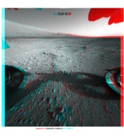
Sol 409 post-drive Front Hazcam, fisheye-corrected 125°, x-eye stereo and anaglyph:
|
|
|
|
|

|
Lo-Fi Version | Time is now: 30th April 2024 - 07:45 PM |
|
RULES AND GUIDELINES Please read the Forum Rules and Guidelines before posting. IMAGE COPYRIGHT |
OPINIONS AND MODERATION Opinions expressed on UnmannedSpaceflight.com are those of the individual posters and do not necessarily reflect the opinions of UnmannedSpaceflight.com or The Planetary Society. The all-volunteer UnmannedSpaceflight.com moderation team is wholly independent of The Planetary Society. The Planetary Society has no influence over decisions made by the UnmannedSpaceflight.com moderators. |
SUPPORT THE FORUM Unmannedspaceflight.com is funded by the Planetary Society. Please consider supporting our work and many other projects by donating to the Society or becoming a member. |
|