Titan's Equatorial Sand Seas |

  |
Titan's Equatorial Sand Seas |
 May 7 2007, 03:53 PM May 7 2007, 03:53 PM
Post
#1
|
|||||||
 Senior Member  Group: Moderator Posts: 2785 Joined: 10-November 06 From: Pasadena, CA Member No.: 1345 |
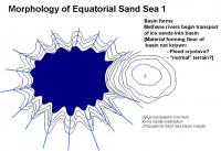
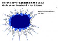
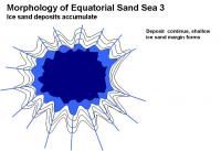
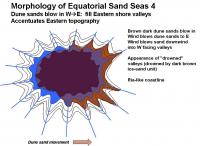
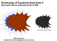
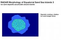
Ive put together a sequence of events that could explain the morphology of the Equatorial Sand Seas. (An example basin similar to Shangri-La is shown)
This could explain the ria-like topography [http://en.wikipedia.org/wiki/Ria] on the Eastern shore, as well as the VIMS dark blue western parts of the Sand seas, and the placement of the dark brown unit on the Eastern parts of the sand seas. 1. Basin formation. 2. Water-ice sand deposition [slowly, suddenly?] forms an ice-sand margin 3. Mobile dark brown dune sands deposit on E side, depositing inland up W facing valleys.
:attachment] The dark brown sands will blow in following the predominantly W winds and make a dust coating on low-lying terrains on the eastern margins. This will be visible by VIMS and ISS as the dark-bright margin, placed inland from the "real margin" and will accentuate the local topography as seen by optical instruments. This accentuation on the E margin will make the Equatorial Sand Sea visible margin look swoopy and windblown (in effect, it is) from the dark basin. Similarly, the W margin will have a dark blue zone that appears blown from the western bright areas. On the Eastern shore, the RADAR images will place the smooth-dark/mottled gray boundary far to the W of the VIMS brown dark-bright margin. (RADAR should be able to penetrate a thin coating of dark sands). The features in the limbo zone have been covered by dark sands, perhaps not enough to form dune structures, but enough to cover up the ice-sand margin, the near shore terrain, and perhaps even some of the underlying bright terrain. This makes the deposition sequence in the Equatorial Sand Seas: 1: Basin formation 2. Major water ice sand emplacement 3. Dune sands cover up low-lying downwind valleys (enough to mask visible imagery) Other Equatorial Sand Sea basins should look very similar around Titan: Shangri-La, Belet, Senkyo, Fensal and Quivra. Local winds may play a bonus role, but the overall trend of dark sand deposition up valley should be towards the E. For example: the false-color image in Figure 6 of the Soderblom paper seems to imply a predominant wind vector in Fensal and Quivra to the ESE. [Im pretty sure all this has been described in pieces before, but it gave me a really great excuse to play with PowerPoint.  ] ]-Mike
Attached thumbnail(s)
-------------------- Some higher resolution images available at my photostream: http://www.flickr.com/photos/31678681@N07/
|
||||||
 |
 
|
||||||
|
May 8 2007, 11:44 PM
Post
#2
|
|||||||
|
Senior Member Group: Moderator Posts: 2785 Joined: 10-November 06 From: Pasadena, CA Member No.: 1345 |
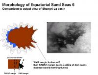
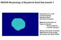
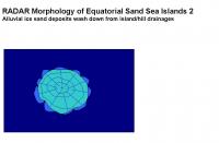
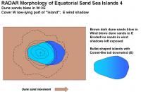
Ive put together another hypothetical series of events that could explain the RADAR appearance of many of the islands seen in the Equatorial Sand Sea.
1. Hill/ridge formation, either before or after the Sand Sea basin forms or is partially filled in. 2. Water ice sand erodes off the hill, forming a debris apron or ice sand margin. 3. Mobile dark brown dune sands deposit on E side, but dont fill in downwind (E) in the wind shadow of the island.
:attachment] This could explain the bullet-shaped appearance of the islands (or ridges) and the ghost-like tails that stretch downwind, usually towards the E. Other tectonic features, like grabens, would also show similar features. The relative height of the island above the equatorial dune sand level partly determines its appearance. Lower islands may not suffer erosion if they are covered by dune sands, so they may have a small or non-existant debris apron.. RADAR will penetrate the obscuring dune sands deeper, so the islands will appear bigger by RADAR than by VIMS or ISS. The eastern side of the island will have dark blue ice sands extending to the E as a tail. This may be visible in VIMS imaging until eventually obscured by a coating of dark brown unit dunes. The islands and features in all the Equatorial Sand Sea basin should look very similar. Islands and ridges in Shangri-La, Belet, Senkyo, Fensal and Quivra should all share a similar appearance. Many of the island ridges may have started out as tectonic features, like parallel ridges (as observed to the W of the Huygens landing area), or hummocks poking out of the basin. As an example, I pulled a RADAR image out of the T8 swath (PIA08454) {Actually, I used the image from TPS, for some reason it was clearer on my computer} -Mike
Attached thumbnail(s)
-------------------- Some higher resolution images available at my photostream: http://www.flickr.com/photos/31678681@N07/
|
||||||
|
|
|
||||||
|
May 9 2007, 02:39 PM
Post
#3
|
|
|
Senior Member Group: Members Posts: 3516 Joined: 4-November 05 From: North Wales Member No.: 542 |
Just in case you're wondering Mike I'm following your posts here with interest. It bothers me that if the prevailing winds are all one way there is still so much dune material out in the open that hasn't made it all the way to western side of a high obstacle by now. Either the wind reverses sometimes or the dune material is occasionally carried right over the 'continents' (without sticking) by exceptional gales. Also, what happens to a dune in a deluge? Shouldn't there be some dunes visibly damaged by flooding? Have we seen that anywhere? Does flooding somehow 'wipe the slate' from dark brown back to dark blue? Too many questions!!! I think we might answer some of them by following the Huygens flood deposits both upstream to their source and downstream to the first appearance of dune material, preferably with all of SAR, ISS and VIMS.
|
|
|
|
|
May 9 2007, 02:51 PM
Post
#4
|
|
|
Rover Driver Group: Members Posts: 1015 Joined: 4-March 04 Member No.: 47 |
I think a massive rain storm around the equator might be useful in that respect to shake things up a bit. I'm thinking equinox here
 Let's hope all is still working and funded by then (only 2.5 more years!) Let's hope all is still working and funded by then (only 2.5 more years!)
|
|
|
|
|
May 9 2007, 05:35 PM
Post
#5
|
|
|
Senior Member Group: Moderator Posts: 2785 Joined: 10-November 06 From: Pasadena, CA Member No.: 1345 |
QUOTE (ngunn @ May 9 2007, 10:39 AM)  Also, what happens to a dune in a deluge? Shouldn't there be some dunes visibly damaged by flooding? Have we seen that anywhere? Does flooding somehow 'wipe the slate' from dark brown back to dark blue? Those are excellent questions. I'm trying to find RADAR images where an obvious stream crosses over either VIMS brown dark unit material or VIMS dark blue unit material. If flooding does 'wipe the slate' from dark brown back to dark blue, I would expect to observe large dark blue margins in some areas along the Eastern shores. (as well as Northern, Southern, and Western shores - but the W ice sand margin is most susceptible to being covered up by windblown dune sands) But we don't see any large ice sand margins in the E. So the dune sand movement apparently happened AFTER the last major dark blue margin flood deposition event. -Mike -------------------- Some higher resolution images available at my photostream: http://www.flickr.com/photos/31678681@N07/
|
|
|
|
|
May 9 2007, 05:55 PM
Post
#6
|
|
|
Member Group: Members Posts: 153 Joined: 14-August 06 Member No.: 1041 |
QUOTE (ngunn @ May 9 2007, 08:39 AM) Just in case you're wondering Mike I'm following your posts here with interest. It bothers me that if the prevailing winds are all one way there is still so much dune material out in the open that hasn't made it all the way to western side of a high obstacle by now. Either the wind reverses sometimes or the dune material is occasionally carried right over the 'continents' (without sticking) by exceptional gales. Very good questions. On earth, we definitely find 'prevailing drift' patterns to the east or west of mountains - even small hills. Another factor to consider is the information released by NASA/Ciclops about the circulation of Saturn today. The atmosphere is flip-flopped from prior models - the 'dark bands' are thought to be drawn up from the deeper layers, while the 'light bands' are thought to originate in the upper atomosphere. This has application to Titan, if it is assumed the Dark bands of Saturn have the same or similar composition to the dark surface features of Titan. Is atmospheric chemistry on Titan a major or minor contributor to the color patterns we see on the surface? |
|
|
|
|
May 10 2007, 07:15 PM
Post
#7
|
|
 Senior Member Group: Moderator Posts: 3242 Joined: 11-February 04 From: Tucson, AZ Member No.: 23 |
QUOTE (Juramike @ May 8 2007, 04:44 PM) Ive put together another hypothetical series of events that could explain the RADAR appearance of many of the islands seen in the Equatorial Sand Sea. 1. Hill/ridge formation, either before or after the Sand Sea basin forms or is partially filled in. 2. Water ice sand erodes off the hill, forming a debris apron or ice sand margin. 3. Mobile dark brown dune sands deposit on E side, but dont fill in downwind (E) in the wind shadow of the island. Yep, that's just about right! -------------------- &@^^!% Jim! I'm a geologist, not a physicist!
The Gish Bar Times - A Blog all about Jupiter's Moon Io |
|
|
|
|
May 10 2007, 11:00 PM
Post
#8
|
||||||
|
Senior Member Group: Moderator Posts: 2785 Joined: 10-November 06 From: Pasadena, CA Member No.: 1345 |
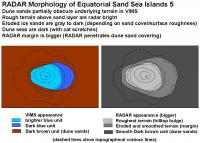
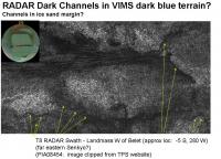
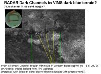
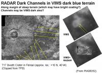
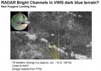
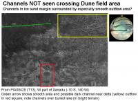
There are a few examples of both RADAR dark and RADAR bright channels lying on top of (presumably) VIMS dark blue deposits in the Equatorial Sand Seas.
These are shown here (channels indicated by yellow arrows):
I was not able to find any examples of a dune field clearly cut through by a channel (either bright or dark). The area near western Xanadu in the T13 RADAR swath shows a large delta complex that feeds into the Shangri-La. A channel may be barely visible, but it does not cut through a dune area located to the W. The dark smooth area may be where a broad outflow fan of ice sands was deposited, then overlain by dune seas. This is shown below (delta indicated inside yellow box, potential channel/outflow fan with green arrow):
So it appears that RADAR-dark channels and RADAR-bright channels overlay dark blue ice sands, but not dark brown dune sands. So deposition sequence (first to last): 1) Dark blue ice sands 2) Channels (RADAR-bright/RADAR-dark) 3) Dark brown dune sands This also implies that the dark blue ice sands are not always infinitely permeable to liquid. They can support a stream, at least in some locations. This is very similar to wet terrestrial sand. Perhaps the dark blue ice sands are almost saturated with liquid, or perhaps they have a slight barrier to the liquid (semi-permeable crust). Perhaps in most locations, a small decent-sized flow can soak in, but a massive flood event will scour across the surface for a distance. In some areas, permeability is locally reduced, and even normal amounts of flow will course across the surface. Since a massive feeder network of channels and ponds is not observed, rain must be able to soak into the sands to some extent. (Impermeable dirt would quickly create an eroded out network.) At the Huygens landing area, there are large and small channels visible in the straights off the island. There are also streams that flow off the island into the dark area. But I could not discern a connecting channel between the channels in the straight, and the outflow of the streams coming off the island. The outflow from the island streams seems absorbed by the dark blue ice sands. Perhaps the channels were carved during major flood events, presumably from the flow coming down the straight (SW to NE) and not from the island streams. From the available data so far, RADAR-bright channels streaking across the ice-sands are not common. This implies that the equatorial sand seas are relatively flat. Irregular rough (RADAR bright) boulders cannot be supported by gradual slopes. The fact that we do observe channels does imply a slight change in elevation, so the Sand Seas are not totally flat. Further analysis should be able to determine flow direction (thus topography). -Mike -------------------- Some higher resolution images available at my photostream: http://www.flickr.com/photos/31678681@N07/
|
|||||
|
|
|
|||||
|
May 11 2007, 07:04 PM
Post
#9
|
|
|
Senior Member Group: Members Posts: 3516 Joined: 4-November 05 From: North Wales Member No.: 542 |
QUOTE (Juramike @ May 11 2007, 12:00 AM) So deposition sequence (first to last): 1) Dark blue ice sands 2) Channels (RADAR-bright/RADAR-dark) 3) Dark brown dune sands -Mike Nice work, Mike. However I would propose an alternative caption to your 1 2 3 list as follows: "Titan surface features in decreasing order of formation timescale:" My reasoning is that the active processes involved are probably all concurrent over the long term. All that's needed to produce the apparent sequence is for the massive outwash floods to be very infrequent compared with 'ordinary' channel-forming rains and dune movement. I'm not even sure about the dunes coming third. Have you found any dunes that have drifted across (and blocked) a channel? |
|
|
|
|
May 11 2007, 07:34 PM
Post
#10
|
|
|
Senior Member Group: Moderator Posts: 2785 Joined: 10-November 06 From: Pasadena, CA Member No.: 1345 |
QUOTE (ngunn @ May 11 2007, 03:04 PM) Nice work, Mike. However I would propose an alternative caption to your 1 2 3 list as follows: "Titan surface features in decreasing order of formation timescale:" Ah, perfect: that the key phrase I was trying to come up with. Thanks! All these process are occuring either simultaneously or episodicaly. From any given point, I'm asking "What is the last event that happened here to make it look this way?" For example: a particular area may have had decades of stream deposition with dunes covering them at the same time, but then a massive flood came along and erased evidence of both of these events. As for dunes covering over channels, I have not yet found any that clearly cut across a dark channel. (Anyone else seen one?) -Mike -------------------- Some higher resolution images available at my photostream: http://www.flickr.com/photos/31678681@N07/
|
|
|
|
|
May 11 2007, 09:46 PM
Post
#11
|
||||
|
Senior Member Group: Moderator Posts: 2785 Joined: 10-November 06 From: Pasadena, CA Member No.: 1345 |
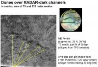
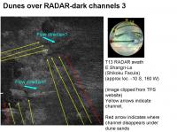
Here are some images and locations where dunes have partially buried a channel:
In the RADAR images of some of the dark channels in an earlier post (#8, above), dunes can be seen at the terminus of the channel. I was not able to find any images where a channel was blocked by dunes, and then the channel was clearly modified by the blocking dune. It appears that dune deposition is the "more-often happening event". The dunes are mobile. Or at least more mobile than the channels. -Mike -------------------- Some higher resolution images available at my photostream: http://www.flickr.com/photos/31678681@N07/
|
|||
|
|
|
|||
|
May 11 2007, 10:08 PM
Post
#12
|
||
|
Senior Member Group: Moderator Posts: 2785 Joined: 10-November 06 From: Pasadena, CA Member No.: 1345 |
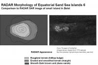
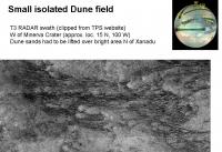
Here is an example of a smaller isolated Dune Sea. This is a smaller area to the W of Minerva Crater in an area North of Xanadu. It is bounded to the W by a bright area (continent? highland?) that presumably should block any sands from entering the basin.
Since there is a sand sea present, either: A. Sand can go over the bright areas. B. Sand can be washed in from bright areas. C. Sand occasionally comes from other directions, but the prevailing flow is generally W. (In this case the basin would be a sand trap) There are several (flat?) RADAR-darker areas in Xanadu that do not have cat-scratch dune fields. This implies that either the RADAR-bright material covers or modifies the sands, or that the sands are not able to flow over large continental masses. Gee, I wonder what is the nature of the bright material? -Mike -------------------- Some higher resolution images available at my photostream: http://www.flickr.com/photos/31678681@N07/
|
|
|
|
|
|
|
May 12 2007, 03:10 AM
Post
#13
|
|
 Senior Member Group: Members Posts: 1281 Joined: 18-December 04 From: San Diego, CA Member No.: 124 |
Thanks for all the awesomeness, Juramike
-------------------- Lyford Rome
"Zis is not nuts, zis is super-nuts!" Mathematician Richard Courant on viewing an Orion test |
|
|
|
|
May 12 2007, 03:40 PM
Post
#14
|
|
 Member Group: Members Posts: 613 Joined: 23-February 07 From: Occasionally in Columbia, MD Member No.: 1764 |
QUOTE (Juramike @ May 11 2007, 03:34 PM) As for dunes covering over channels, I have not yet found any that clearly cut across a dark channel. (Anyone else seen one?) -Mike Wish I had as much time to spend on analysing the Cassini data as you do! Between Cassini observation planning and the Titan flagship study (presentation to OPAG should go up on the OPAG website in due course), I'm barely managing to read all the posts..... I think in the bright area to the East of Menrva on T3 (with all the anabranching channels) you will see a couple of faint dark streaks on the bright oval, suggesting these are dunes that are superposed on a fluvial basin... |
|
|
|
|
May 12 2007, 07:35 PM
Post
#15
|
|
|
Senior Member Group: Members Posts: 3516 Joined: 4-November 05 From: North Wales Member No.: 542 |
Mike, in your first illustration in post 11 (for example) I'm not quite sure what sequence of events is evidenced. Where your upper yellow arrows are pointing the dune pattern, including whatever constitutes the inter-dune surface, certainly continues uninterrupted. However it's not clear that the dark channel was continuous at this point until being buried by the dunes. Where the lower arrows are pointing is very interesting though. I can persuade myself that I am seeing a very narrow channel that has been 'recut' through the ends of the dunes. It would be interesting to look for more like that. (I'm sure you will!)
|
|
|
|
|

|
Lo-Fi Version | Time is now: 27th September 2024 - 06:06 AM |
|
RULES AND GUIDELINES Please read the Forum Rules and Guidelines before posting. IMAGE COPYRIGHT |
OPINIONS AND MODERATION Opinions expressed on UnmannedSpaceflight.com are those of the individual posters and do not necessarily reflect the opinions of UnmannedSpaceflight.com or The Planetary Society. The all-volunteer UnmannedSpaceflight.com moderation team is wholly independent of The Planetary Society. The Planetary Society has no influence over decisions made by the UnmannedSpaceflight.com moderators. |
SUPPORT THE FORUM Unmannedspaceflight.com is funded by the Planetary Society. Please consider supporting our work and many other projects by donating to the Society or becoming a member. |
|