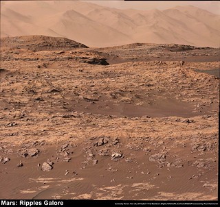
Exploring Mt Sharp - The Dunes - Part 1: Bagnold Dunes, Site 51-53, Sol 1172-1273, November 24, 2015-March 6, 2016 |

  |
Exploring Mt Sharp - The Dunes - Part 1: Bagnold Dunes, Site 51-53, Sol 1172-1273, November 24, 2015-March 6, 2016 |
 Nov 26 2015, 12:33 PM Nov 26 2015, 12:33 PM
Post
#16
|
|
 Senior Member  Group: Members Posts: 2428 Joined: 30-January 13 From: Penang, Malaysia. Member No.: 6853 |
|
 |
 
|
|
Nov 26 2015, 09:08 PM
Post
#17
|
|
 Member Group: Members Posts: 809 Joined: 3-June 04 From: Brittany, France Member No.: 79 |
My take on these recent panoramas of dunes and mountains:
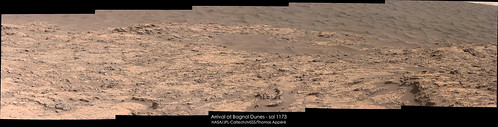   -------------------- |
|
|
|
|
Nov 27 2015, 12:50 AM
Post
#18
|
||
|
Senior Member Group: Members Posts: 2428 Joined: 30-January 13 From: Penang, Malaysia. Member No.: 6853 |
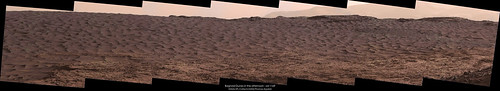
QUOTE (neo56 @ Nov 27 2015, 05:08 AM)  My take on these recent panoramas of dunes and mountains: Magnifique Thomas.....  Meanwhile: Let me share this wallpaper of Dune 2 @Bagnold (2560 x 1080 pixels) It comes with an extended sky, which I think really makes the NavCam's pop. Parts of Mount Sharp from Sol 1169 were used to fill out the horizon. From the stitching alone you can see that it's not my work, but from someone who has applied for membership here at UMSF. Hopefully that application will be processed soon, so we can see more of these images.
Imgur: Link |
|
|
|
|
|
|
Nov 27 2015, 07:15 PM
Post
#19
|
|
|
Member Group: Members Posts: 809 Joined: 3-June 04 From: Brittany, France Member No.: 79 |
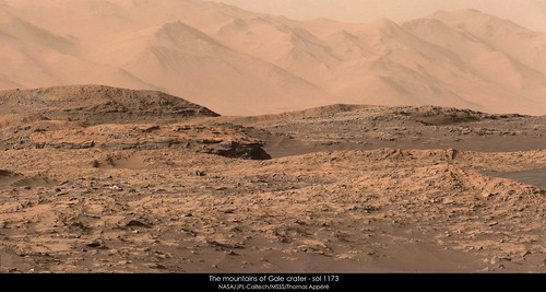
Another view of the wall of Gale crater, this time looking west:
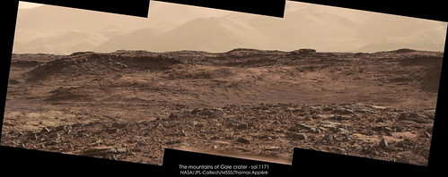 And with contrast increased to highlight gully-like features on the side of the mountains: 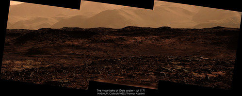
-------------------- |
|
|
|
|
Nov 30 2015, 07:15 PM
Post
#20
|
|
 Member Group: Members Posts: 244 Joined: 2-March 15 Member No.: 7408 |
|
|
|
|
|
Nov 30 2015, 08:18 PM
Post
#21
|
||
 Member Group: Members Posts: 691 Joined: 21-December 07 From: Clatskanie, Oregon Member No.: 3988 |
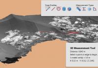
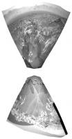
Here is a 3D DTM model that I generated using Navcam images from Sol-1174. You can rotate, and zoom up in the scene and even measure the size of objects and distances.
Adobe 3D PDF (6.2 Megs) https://www.dropbox.com/s/aj5ejvfgu1cl8in/M...htside.pdf?dl=1 |
|
|
|
|
|
|
Dec 1 2015, 08:08 PM
Post
#22
|
|
|
Member Group: Members Posts: 809 Joined: 3-June 04 From: Brittany, France Member No.: 79 |
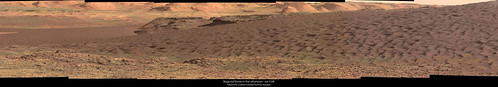
Two sections of the panorama taken with MC100 on sol 1169 at 16h10 local time. These two sections can be combined together but the MC100 picture that makes the connection was not taken with the same exposure time, hence it is difficult to debayer and calibrate colors correctly.
-------------------- |
|
|
|
|
Dec 2 2015, 07:17 AM
Post
#23
|
|
|
Senior Member Group: Members Posts: 2428 Joined: 30-January 13 From: Penang, Malaysia. Member No.: 6853 |
Mission Update by Ken Herkenhoff - Sol 1181: Mobility testing LINK
QUOTE Due to problems at the Goldstone DSN complex, the bundle of command sequences generated for Sol 1180 could not be sent to MSL. So the rover performed minimal activities on Sol 1180, as expected in runout mode. The good news is that the rovers batteries are charged up, and the engineering team determined that activities can be planned after the heater table update by avoiding the types of heating that are affected by the update. So the Sol 1181 plan includes the first part of the mobility test: drive a few meters into the dark sand in front of the rover, then back up enough to allow study of the rover tracks using the arm instruments. During the drive, MARDI will acquire many images of the surface behind the left front wheel, to document the sand as it is disturbed by the wheel. After the drive and the standard post-drive imaging are completed, ChemCam will observe its calibration targets, RMI and Mastcam will image part of Mount Sharp in the distance, and Navcam will search for clouds.
|
|
|
|
|
Dec 2 2015, 12:14 PM
Post
#24
|
|
|
Senior Member Group: Members Posts: 2428 Joined: 30-January 13 From: Penang, Malaysia. Member No.: 6853 |
|
|
|
|
|
Dec 2 2015, 02:57 PM
Post
#25
|
||
 Senior Member Group: Members Posts: 4246 Joined: 17-January 05 Member No.: 152 |
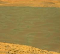
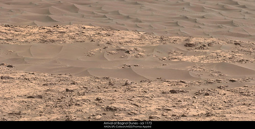
Interesting hue variations on the dunes. Here I've increased the saturation:
Redder in between the crests, perhaps due to more dust collecting there? |
|
|
|
|
|
|
Dec 2 2015, 07:14 PM
Post
#26
|
||
|
Solar System Cartographer Group: Members Posts: 10157 Joined: 5-April 05 From: Canada Member No.: 227 |
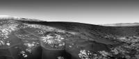
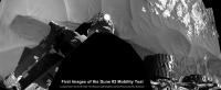
Reprojected Hazcam images show a little toe-dip into the dark sand on sol 1181.
Phil
-------------------- ... because the Solar System ain't gonna map itself.
Also to be found posting similar content on https://mastodon.social/@PhilStooke Maps for download (free PD: https://upload.wikimedia.org/wikipedia/comm...Cartography.pdf NOTE: everything created by me which I post on UMSF is considered to be in the public domain (NOT CC, public domain) |
|
|
|
|
|
|
Dec 2 2015, 07:27 PM
Post
#27
|
||
|
Member Group: Members Posts: 691 Joined: 21-December 07 From: Clatskanie, Oregon Member No.: 3988 |
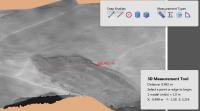
A 3D DTM of one of the wheel tracks into the dune-ripples on Sol-1181.
Adobe 3D PDF (8.7 Megs) http://bit.ly/1N41Yp6 |
|
|
|
|
|
|
Dec 2 2015, 11:21 PM
Post
#28
|
||
|
Senior Member Group: Members Posts: 2428 Joined: 30-January 13 From: Penang, Malaysia. Member No.: 6853 |
QUOTE (James Sorenson @ Dec 3 2015, 03:27 AM) A 3D DTM of one of the wheel tracks into the dune-ripples on Sol-1181. Great work James and a very useful measuring tool... Meanwhile here is a few more of the available L-NavCam's roughly stitched and cropped of the RH side of the rover recording the journey on and off the leading edge of the sands
Imgur LINK |
|
|
|
|
|
|
Dec 3 2015, 05:15 PM
Post
#29
|
|
|
Solar System Cartographer Group: Members Posts: 10157 Joined: 5-April 05 From: Canada Member No.: 227 |
http://www.midnightplanets.com/web/MSL/ima...CAM02181L1.html
Some great new RMI images looking over the dunes to the terrain beyond, on sol 1181. Phil -------------------- ... because the Solar System ain't gonna map itself.
Also to be found posting similar content on https://mastodon.social/@PhilStooke Maps for download (free PD: https://upload.wikimedia.org/wikipedia/comm...Cartography.pdf NOTE: everything created by me which I post on UMSF is considered to be in the public domain (NOT CC, public domain) |
|
|
|
|
Dec 3 2015, 08:50 PM
Post
#30
|
|
|
Junior Member Group: Members Posts: 58 Joined: 9-April 15 Member No.: 7433 |
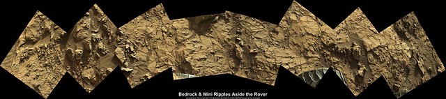
QUOTE (PaulH51 @ Dec 2 2015, 05:14 AM) Sol 1173: L-MastCam, MS ICE, enhanced. All three RH side wheels and a mix of exposed bedrock and mini-ripples Awesome!!! Can you do for SOL 1176? There is an awesome disturbed area...I stitched together, but my skills really well, not the best. |
|
|
|
|

|
Lo-Fi Version | Time is now: 4th May 2024 - 08:13 AM |
|
RULES AND GUIDELINES Please read the Forum Rules and Guidelines before posting. IMAGE COPYRIGHT |
OPINIONS AND MODERATION Opinions expressed on UnmannedSpaceflight.com are those of the individual posters and do not necessarily reflect the opinions of UnmannedSpaceflight.com or The Planetary Society. The all-volunteer UnmannedSpaceflight.com moderation team is wholly independent of The Planetary Society. The Planetary Society has no influence over decisions made by the UnmannedSpaceflight.com moderators. |
SUPPORT THE FORUM Unmannedspaceflight.com is funded by the Planetary Society. Please consider supporting our work and many other projects by donating to the Society or becoming a member. |
|