Printable Version of Topic
Click here to view this topic in its original format
Unmanned Spaceflight.com _ Perseverance- Mars 2020 Rover _ Finishing work in and around Seitah, sols 238-378
Posted by: Phil Stooke Oct 21 2021, 06:50 AM
It's time to start a new thread - this will cover the remaining work in Seitah and the drive back to the landing site.
Phil
Posted by: Phil Stooke Oct 22 2021, 12:13 AM
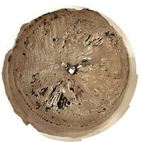
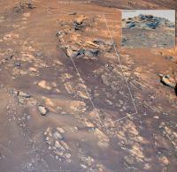
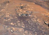
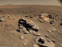
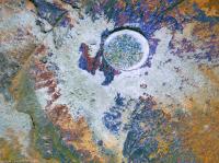
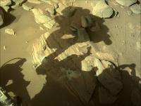
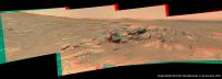
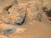
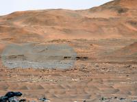
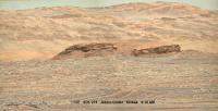
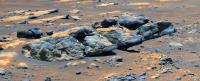
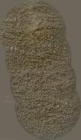
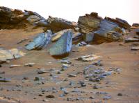
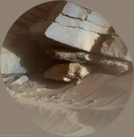
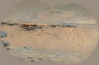
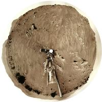
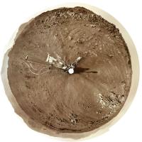
OK, a drive up to the outcrop on sol 238. Here is a circular view of the new location.
Phil
|
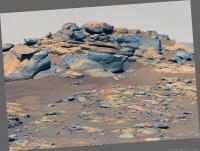
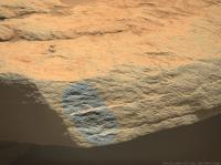
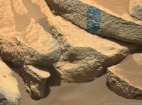
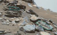
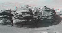
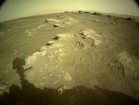
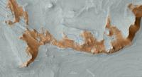
Posted by: tau Oct 22 2021, 12:13 PM
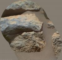
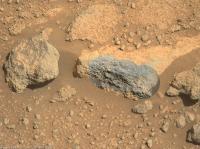
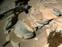
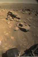
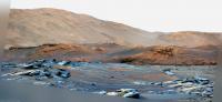
An outcrop of compact, layered rock with overlying vesicular rock fragments on sol 238.
Mastcam-Z left eye filter 0 (RGB), colors enhanced.
|
Posted by: Bill Harris Oct 22 2021, 04:19 PM
Tau, this stratigraphy is getting interesting.
Time to backtrack and try to intuit the bedding orientation.
--Bill
Posted by: serpens Oct 22 2021, 10:16 PM
Perseverance had a pretty fair tilt when this was taken and these are probably as horizontal as the precious ridge.
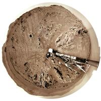
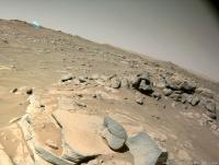
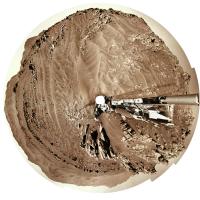
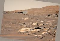
Posted by: Phil Stooke Oct 23 2021, 12:46 AM
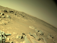
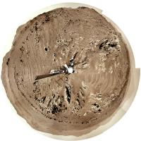
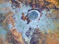
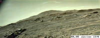
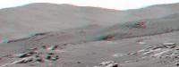
Sol 239, another drive... another circular panorama.
Phil
|
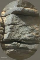
Posted by: serpens Oct 23 2021, 01:20 AM

To me this looks more like honeycomb weathering of basaltic sandstone rather than vesicular basalt tau, but I stand to be corrected.
Posted by: tau Oct 23 2021, 12:45 PM
If the term "vesicular" implies a specific type of rock or origin of the rock, then I would rather refer to it as "spongeous appearance".
I would not rule out weathering as the reason of the small holes/cavities.
Posted by: tau Oct 23 2021, 07:18 PM
Time to backtrack and try to intuit the bedding orientation.
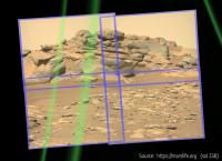
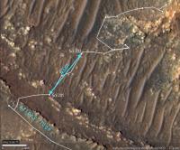
As to the bedding orientation, here is a sol 236 Navcam image with the sol 238 Mastcam-Z image as inset. If there is any tilt of the rover, it seems to be rather small.
Navcam and Mastcam-Z are looking east-northeast. The layers are dipping to the right, i.e., towards the Artuby ridge.
This is consistent with the Rimfax results in the screenshot below, which is from a presentation by Kathryn Stack Morgan. Thanks to cIclops for the link to this very interesting video!
The part about Rimfax and Séítah layering begins after 21 minutes. Here is a https://youtu.be/1pnaLETPWC4?t=1252.
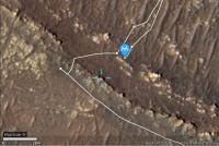
The field of view of the sol 238 Mastcam-Z image and the position of Perseverance on sol 239 are marked in the upper right section of a https://mars.nasa.gov/mars2020-raw-images/pub/ods/surface/sol/00174/ids/edr/browse/heli/HSF_0174_0682390593_685ECM_N0120001HELI00005_000085J02.png.
|

|
|
EDIT: Corrected the compass direction that the Navcam and Mastcam-Z looked at. I had accidentaly typed west where I meant east. The correct direction is east-nordeast.
Posted by: Bill Harris Oct 23 2021, 07:31 PM
I haven't had the chance to look at that video presentation yet.
The RIMFAX data fairly well corresponds to my general observations. In a general sense, the "beds are essentially flat-lying with a gentle regional dip to the southwest". Artuby ridge is stratigraphically the high point of this section of the traverse and we are headed along stratigraphically lower units. And Artuby is the youngest unit, and we are traversing along increasingly older units.
Nice presentation of yours.
--Bill
Posted by: serpens Oct 23 2021, 10:49 PM
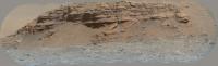
Indeed, good one tau. The Rimfax trace doesn't show any real change in the angle of dip despite a 90 degree turn across the terrain, not that I have any skill whatsoever in interpreting such.
The reason I suspected an element of tilt was due to this Sol 238 Navcam image.
|
Posted by: Phil Stooke Oct 24 2021, 12:07 AM
That picture was taken at the sol 238 location, but Tau's image was from the sol 237 location, before the drive on sol 238.
Phil
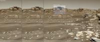
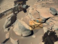
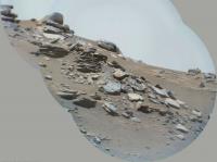
Posted by: PaulH51 Oct 24 2021, 10:45 AM
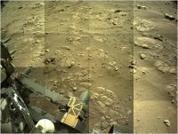
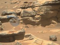
4x4 Navcam tile of Perseverance's post-drive workspace on sol 239.
Very roughly assembled and reduced to fit upload limits
|
Posted by: tau Oct 24 2021, 04:41 PM
The tilt of the previously shown sol 238 Mastcam-Z picture can be estimated with the projection of the images onto a sphere provided online by https://marslife.org.
The mast was tilted about 4° to the left (that's more than I presumed from the Navcam photos). When we apply the tilt to the picture, the layers are still tilted to the right (towards Artuby ridge) with an angle of about 7° to 8°.
This is in accordance with the http://www.unmannedspaceflight.com/index.php?act=attach&type=post&id=49594 where we have a dip angle of about 12° towards Artuby ridge.
|
|
Posted by: Bill Harris Oct 24 2021, 09:15 PM
This site you noted, https://marslife.org/ , looks interesting and potentially useful. Let me dig around and find documentation on the site.
--Bill
Posted by: serpens Oct 25 2021, 12:08 AM
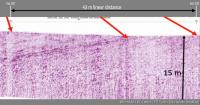
The dipping structure in the Rimfax trace seems to disappear at the third position Tau and it would be interesting to see subsequent results to determine if similar structure re-appears. The trace presentation seems to be truncated in the X axis which accentuates the angle of dip which if the trace were extended to agree with the 15 metre depth would be around 7 degrees.
Posted by: tau Oct 25 2021, 05:19 PM
The Rimfax diagram has two small marks for sol 201 and sol 202.
In the Hirise map, the positions of sol 201 and sol 202 can be connected by a stright line ("as the crow flies") with a linear distance of about 43 m.
This line is almost perpendicular to Artuby ridge. The ridge can be assumed to represent a strike line of the layers.
When the Rimfax diagram between sol 201 and sol 202 is stretched horizontally according to the vertical scale, we get a dip angle of about 11° to 12°.
|
|
Posted by: tau Oct 26 2021, 04:12 PM
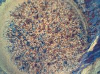
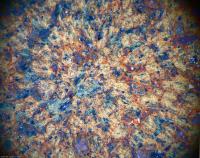
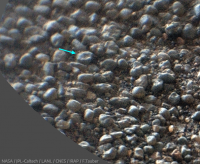
Sol 242 SuperCam Remote Micro Imager with double context.
Grain-size measurement by stereoscopy gives an average grain diameter of about 1.3 mm
|
|

|
Posted by: PaulH51 Nov 1 2021, 12:02 AM
Roughly processed sol 248 end-of-drive 4 tile Navcam. The site index incremented which could indicate we are at, or very close to the next sample site.

|
Posted by: Phil Stooke Nov 1 2021, 03:15 AM
Yes, a move, but really just a turn in place (possibly involving a drive downslope, a turn and back upslope, but I only see the end result).
Phil
Posted by: Bill Harris Nov 1 2021, 08:54 AM
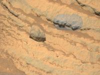
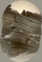
Plenty of interesting contacts here. Especially that (apparently) loose rock at the top with the dark basaltic (?) unit on top of the grey clastic (?) unit on top of the in-place units.
--Bill
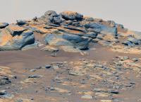
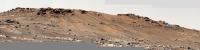
Posted by: tau Nov 1 2021, 01:05 PM
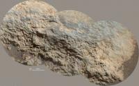
Kodiak behind Séítah as seen by the SuperCam Remote Micro-Imager on Sol 248
|
Posted by: Phil Stooke Nov 1 2021, 04:33 PM
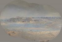
That's a beautiful image of Kodiak. Thanks!
Here is a circular panorama for the current position.
Phil
|
Posted by: Phil Stooke Nov 1 2021, 05:35 PM
Paul: "The site index incremented which could indicate we are at, or very close to the next sample site."
I was asked about site numbering, and i don't have specific information about Persererance, but this is a document for Curiosity which discusses sites. MSL_Coordinate_Frames_Mar5_2013.pdf ( 343.63K )
: 364
MSL_Coordinate_Frames_Mar5_2013.pdf ( 343.63K )
: 364
I expect the situation is the same for Perseverance. A new site number doesn't really suggest sampling is about to happen, though I expect it is.
Phil
Posted by: djellison Nov 1 2021, 06:38 PM
The site incrementing is usually because the propagated error in attitude knowledge has reached a certain limit. It's usually based on cumulative IMU on time.
Posted by: tau Nov 1 2021, 08:43 PM
Sol 247 SuperCam RMI with Mastcam-Z context and sol 147 Helicopter color camera context
|
|
|
Posted by: tau Nov 5 2021, 05:01 PM
Sol 252 SuperCam RMI with Mastcam-Z and Navcam context
|
|
|
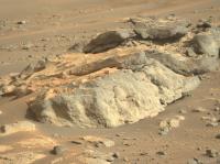
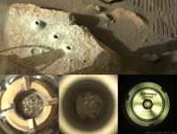
Posted by: PaulH51 Nov 6 2021, 08:09 AM
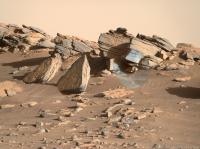
Sol 253: Processed R-Navcam (4-tiles) assembled in MS-ICE shows the latest abrasion target 'https://sketchfab.com/3d-models/m2020-zcam-brac-pre-abrasion-sol-249-8127c8cde2f24ba989dbdc456c65b816'

|
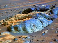
Posted by: tau Nov 6 2021, 01:27 PM
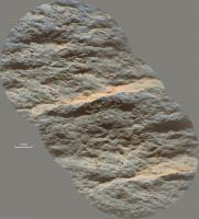
A sol 253 Sherloc Watson camera image with enhanced colors and an anaglyph of the abrasion target.
Could that small white triangle above the center of the abraded area be a lost part of the abrasion tool?
|
|
Posted by: tau Nov 6 2021, 06:05 PM
Sol 253 SuperCam RMI with Mastcam-Z and Navcam context
|
|
|
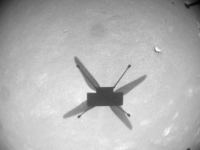
Posted by: PaulH51 Nov 6 2021, 09:43 PM
Mars Helicopter - November 6, 2021 (Sol 254) Flight 15 NavCam - 12:06 local time
|
Posted by: charborob Nov 8 2021, 02:50 PM
Sol 254 LMastcam-Z:
|
|
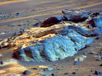
Posted by: tau Nov 8 2021, 07:44 PM
The sol 253 abrasion target in sol 255 Mastcam-Z images
1. Raw image left eye filter 0 (visible RGB)
2. Left eye filters 0 to 6 multispectral principal components
3. Right eye filter 0 (RGB) and infrared filters 1 to 6 multispectral principal components
1
|
|
|
Posted by: tau Nov 10 2021, 06:40 PM
The abraded surface in a combination of sol 257 images with SHERLOC Autofocus and Context Imager for detail and SHERLOC WATSON camera for enhanced color.
Do I see concentric zoning and lamellae in some crystals (I do not mean the visible effect of the abrading tool hammering), or are these just image artifacts or imagination ?
|
Posted by: Bill Harris Nov 10 2021, 08:21 PM
We do see zoning as well as lamellae in these mineral grains. I'm thinking that the zonation is due to weathering in a wet and oxygenated environment. These rocks are covered with a weathering crust and this abraded area is just beneath that zone.
--Bill
Posted by: tau Nov 12 2021, 05:55 PM
Sol 256 SuperCam Remote Micro Imager with Mastcam-Z context and anaglyph
|
|
|
Posted by: Bill Harris Nov 13 2021, 12:34 AM
Percy hasn't covered much distance since leaving the Artuby ridge. But the Micro Imager shows consistent grain size, sorting, and angularity in several images. More important than the linear surface distance is the stratigraphic interval, which covers time as well as space. We don't know the deposition rates yet, so this time interval could be years, tens, or hundreds or thousands.
--Bill
Posted by: Phil Stooke Nov 13 2021, 06:37 PM
Since this is Mars, it could be hundreds of millions of years.
Phil
Posted by: tau Nov 14 2021, 04:56 PM
Sol 248 Mastcam-Z. Kodiak with enhanced colors and as anaglyph.
The stereoscopic effect is quite weak because of the large distances.
The visible distant part of Séítah is about 1 km away, Kodiak 2 km, and the inner crater wall about 7 km and more.
|

|
Posted by: PaulH51 Nov 15 2021, 11:30 AM
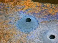
Latest sample from Jezero imaged in the rover's coring bit.
November 15, 2021 (Sol 262)
Edit: Added L-Navcam of the hole
Edit#2: roughly assembled raw 4-tile L-Navcam (MS-ICE)
All jpg'ed to reduce server impact

|
|
|
Posted by: neo56 Nov 15 2021, 09:42 PM
My take on the 4-tile NavCam Left mosaic.
https://flic.kr/p/2mK4Ew5
Posted by: PaulH51 Nov 15 2021, 11:08 PM
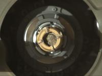
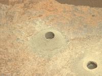
Sol 262 CacheCam shows the core is in at least two sections. The 2nd (later) image provides us a with a side-on view of the upper section of the core closest to the camera.
I'm assuming the upper section of the core rotated after the static probe was used at the Volume station to measure the size of the sample, and to ensure there was room to fit the seal.
I'm sure geologists will enjoy this bonus side-on view of the split core and its grain structure.

|
Posted by: tau Nov 18 2021, 11:16 AM
Sol 255 SuperCam Remote Micro Imager with context images (2 Mastcam-Z sol 255, 1 Navcam sol 253), ordered by decreasing focal length
|
|
|
|
Posted by: vikingmars Nov 18 2021, 03:58 PM
Thanks a lot Tau for this superb work of yours

Posted by: tau Nov 18 2021, 04:46 PM
Sol 265 SuperCam Remote Micro Imager with context images Mastcam-Z sol 241 and Navcam sol 248.
It took me a while to find appropriate context images.
|
|
|
Posted by: john_s Nov 18 2021, 06:25 PM
Looks like there may be some ripple structures preserved in the rock in that image.
John
Posted by: tdemko Nov 19 2021, 12:56 AM
I see what you are talking about, at some of the bed boundaries. There is also a fallen piece that has a bedding plane exposed with what could be small 3D dunes or ripples (can't quite determine the scale). They both are not pleasingly preserved, at least from here, so we'll have to wait and see. We've been seeing distinct bed boundaries for a while, in several places along the traverse, at several stratigraphic intervals. None of them looked completely planar, but there were no obvious ripple forms either, let alone cross-stratification within the beds. After finally determining that the grain size was in the medium-coarse to granule range, that's not surprising. Maybe the grain size is smaller in these outcrops, and ripples and dunes could have formed during the flows.
Posted by: xflare Nov 19 2021, 08:23 PM
John
Which image are you referring to?
Posted by: john_s Nov 19 2021, 08:46 PM
http://www.unmannedspaceflight.com/index.php?s=&showtopic=8661&view=findpost&p=255151. Specifically the wavy bedding planes left of center, and the funky-looking slab surface on the slope just lower right of center.
John
Posted by: tau Nov 20 2021, 12:59 PM
Here is a detail of the http://www.unmannedspaceflight.com/index.php?act=attach&type=post&id=49728 mentioned above. Those two rocks caught my attention, too.
|
Posted by: tau Nov 20 2021, 08:10 PM
Regarding the scale, here is a sol 265 Mastcam-Z context panorama for the sol 265 SuperCam detail image (bluish rectangle to the right), and a HiRISE map of the panorama's field of view.
The target taken by the SuperCam is circled on the map. It is almost exactly 200 m away from the rover.
With some calculations it came out that the visible distance between the suspected ripple crests is about 9 to 10 cm in the SuperCam detail image (see previous post).
|
|
Posted by: Phil Stooke Nov 24 2021, 06:44 PM
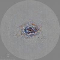
A second drill hole and sample just done at Brac.
https://mars.nasa.gov/mars2020-raw-images/pub/ods/surface/sol/00271/ids/edr/browse/ncam/NLF_0271_0691011600_601EBY_N0080000NCAM00705_03_0LLJ01_800.jpg
Phil
Posted by: neo56 Nov 24 2021, 08:50 PM
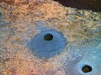
Here is a picture of the second drill hole in Brac taken on sol 271.

|
Posted by: Phil Stooke Nov 26 2021, 12:31 AM
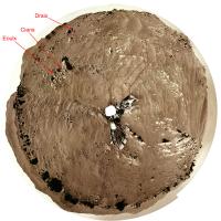
I have collected and labelled images of the various sampling (and related activities) sites with the names as I know them so far. I don't yet have a name for the most recent sample hole. All images are oriented roughly north-up, not in raw image orientation.
Phil
|
|
Posted by: vikingmars Nov 26 2021, 05:00 PM
Sol 265 partial pan and also in 3D. Enjoy
|
Posted by: vikingmars Nov 26 2021, 05:03 PM
|
Because the distances between the foreground and background are big, take some time to let your eyes adapt

Posted by: PaulH51 Nov 27 2021, 01:46 AM
Sol 271: CacheCam 2-tile fusion stitch of sample number 5 in its tube prior to sealing, roughly assembled in MS-ICE (unprocessed other than the stitch)

|
Posted by: vikingmars Nov 27 2021, 07:23 AM
Sol 248 of Perseverance's mission : more spectacular rocks to be seen... and also in 3D. Enjoy
|

|
Posted by: tau Nov 28 2021, 05:22 PM
Sol 274 SuperCam Remote Micro Imager with sol 274 and sol 265 Mastcam-Z context
|
|
|
|
Posted by: charborob Nov 29 2021, 02:18 PM
Sol 275 Lmastcam-Z:
|
|
Posted by: vikingmars Nov 29 2021, 03:56 PM
What a nice mosaic! Thanks Robert to share this work with us
Posted by: vikingmars Dec 1 2021, 08:15 AM
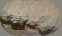
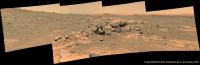
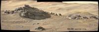
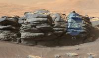
Sol 239 : here is one of the nicest views with gorgeous piles of rocks taken during the whole mission !
Also in 3D. Enjoy

|

|

|
Posted by: Sean Dec 1 2021, 04:30 PM
Here is my hasty effort ( avoid the extended sky! ) for Sol 275 MZR along with a 4k video on https://youtu.be/xS8JttdFOIY


Posted by: Phil Stooke Dec 1 2021, 06:08 PM
Very nice, Sean. Thanks!
Sol 278 - we just had a small move uphill, so the rover is now above Brac - behind it from the previous perspective.
Phil
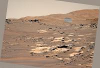
Posted by: Phil Stooke Dec 1 2021, 07:29 PM
A quick circular panorama for sol 278.
Phil
|
Posted by: tau Dec 3 2021, 05:33 PM
Sol 280 SuperCam Remote Micro Imager with sol 275 Mastcam-Z context showing the planned entrance to the delta remnants near a location on the crater floor called "Three Forks".
Will there be a continuation with some SuperCam RMI images on the right?
|
|
Edit: For extended context, check out the center of Sean's beautiful panorama in post #63.
Second edit: "Planned entrance" refers to https://photojournal.jpl.nasa.gov/catalog/PIA24379 in the JPL Photojournal from January 2021, that was before landing. Plans may have changed meanwhile.
Posted by: Phil Stooke Dec 3 2021, 08:09 PM
Sol 280, a circular view with lots of nice sandy ripples. This looks like the start of the return journey so it will lead to a new map.
Phil
|
Posted by: Phil Stooke Dec 5 2021, 08:43 AM
Another drive on sol 281 - here is a circular version of a panorama.
Phil
|
Posted by: tau Dec 6 2021, 04:49 PM
The planned entrance to the delta remnants in sol 280 Mastcam-Z images.
1. Raw image
2. Contrast enhanced
3. With simulated haze to emphasize the relief and the landscape units, and with distances from the rover position on sol 280
4. Left eye filters 1 to 6 multispectral principal components
1

|

|

|

|
For SuperCam details see also post #66.
Edit: "Planned entrance" refers to https://photojournal.jpl.nasa.gov/catalog/PIA24379 in the JPL Photojournal from January 2021, that was before landing. Plans may have changed meanwhile.
Posted by: Phil Stooke Dec 6 2021, 10:41 PM
Sol 283, we had a small move, a few m only, to the NE plus a rotation.
Phil
EDIT: here's a circular panorama for sol 283.
|
Posted by: PDP8E Dec 7 2021, 02:51 AM
SOL 275 9:15 AM
This is a part of the morning PAN (Kodiak) -- 4 image stitch
Adaptive-Equalization
|
Posted by: tau Dec 7 2021, 10:05 AM
Layered outcrops in Séítah with Kodiak and the crater wall in the background on sol 282
1. Mastcam-Z right eye filter 0 (RGB), colors enhanced by principal components analysis
2. Anaglyph with impressive stereo effects (best seen on displays with wide gamut or extended color space)
1

|

|
Posted by: PDP8E Dec 8 2021, 03:08 AM
SOL 283
We have clouds ...

|
Posted by: vikingmars Dec 8 2021, 08:54 AM
Sol 284: nice afternoon clouds. Enjoy

|
Posted by: vikingmars Dec 8 2021, 06:24 PM
Sol 279.
I could not resist building this small panorama that shows such a romantic view with its scattered rock piles seen at late afternoon: this is the 'Mars' dreamed by Ray Bradbury.
Also in 3D. Enjoy

|
Posted by: vikingmars Dec 8 2021, 06:26 PM
(cont.)

|
Posted by: Phil Stooke Dec 9 2021, 08:05 AM
Here is a circular panorama after the sol 285 drive. The next drive might just get out of Seitah, or to the bottom of the last slope.
Phil
|
Posted by: PaulH51 Dec 9 2021, 09:44 PM
Welcome to site 9...
Sol 286: 4-tile Navcam (roughly assembled in MS-ICE)
EDIT: Looks like a drive SSW by about 8 meters

|
Posted by: PDP8E Dec 9 2021, 11:08 PM
Sol 285 -- 2:28 PM
Early afternoon clouds over the crater rim -- deltas in the foreground
|
Posted by: PaulH51 Dec 12 2021, 12:24 AM
Looks like we may not be leaving Seitah as soon as I expected?
Sol 288 Hazcam (jpeg'd to save space)
Drill press? or maybe abrasion preparation?
Watch this space

|
Posted by: charborob Dec 12 2021, 03:25 AM
Sol 288 LMastcam-Z:
|
|
Posted by: PDP8E Dec 12 2021, 05:37 AM
Here is a subset of SOL88 Lmastcam-Z
|
Posted by: Bill Harris Dec 12 2021, 04:46 PM
Back at Artuby.
Posted by: tau Dec 12 2021, 07:15 PM
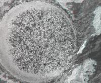
SuperCam Remote Micro Imager with Mastcam-Z and Navcam context on sol 286 at the edge of Séítah.
Stereophotometry gives an average grain diameter of about 1.3 mm

|

|

|
Posted by: tau Dec 12 2021, 10:18 PM
A pretty fragile structure on sol 286.
Mastcam-Z anaglyph and left eye filter 0 (RGB) with enhanced colors.

|
|
Posted by: Phil Stooke Dec 13 2021, 06:37 AM
Circular panorama for sol 286.
Phil

|
Posted by: PDP8E Dec 14 2021, 02:03 AM
Here is a local ridge PAN on SOL 289 -- 4:10 PM
|
|
Posted by: charborob Dec 14 2021, 04:27 PM
Sol 290 LMastcam-Z:
|
|
Posted by: tau Dec 14 2021, 05:10 PM
Many interesting panoramas in these days and sols.
Here comes sol 290 SuperCam Remote Micro Imager with context (Mastcam-Z and Navcam sol 288, HiRISE) and Mastcam-Z anaglyph.
The bright pebble in the SuperCam image to the right of center, enclosed between two layers, has a horizontal size of about 13 mm.
The distance from the rover to the SuperCam target is 18 m.
|
|

|
|
|
Posted by: tau Dec 14 2021, 09:42 PM
Sol 290 Mastcam-Z
1. Left eye filter 0 (RGB) raw image
2. Left eye filters 1 to 6 multispectral principal components
3. Right eye filters 0 to 6 multispectral principal components
The small sharp-edged fragments with a slightly purple tint in the foreground are probably made of a different material than the other rocks in the image.
|
|
|
Posted by: vikingmars Dec 15 2021, 10:17 AM
The next poster to be seen on the wall of my office. Enjoy

|
Posted by: Cherurbino Dec 15 2021, 12:18 PM
With what instrument was this test performed? (sol 291)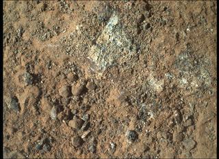
(full_res: https://mars.nasa.gov/mars2020-raw-images/pub/ods/surface/sol/00291/ids/edr/browse/shrlc/SIF_0291_0692782532_679EBY_N0090000SRLC00704_0000LMJ01.png)

|
Posted by: Floyd Dec 15 2021, 12:58 PM
Deliberate wheel scrape? There seem to be parallel scratches that a wheel scrape would make. Just a guess.
Posted by: tau Dec 15 2021, 05:22 PM
At first I had also thought of wheel scratches. But the lack of wheel marks around the rock and the timing looks like an abrasion attempt.
An uneven surface with rounded granules apparently prevented successful abrasion. Some of the granules were crushed.

|
Links to the original raw images:
https://mars.nasa.gov/mars2020-raw-images/pub/ods/surface/sol/00291/ids/edr/browse/zcam/ZL0_0291_0692781524_700EBY_N0090000ZCAM05066_0340LMJ01.png
https://mars.nasa.gov/mars2020-raw-images/pub/ods/surface/sol/00291/ids/edr/browse/fcam/FRF_0291_0692782417_802ECM_N0090000FHAZ00206_01_295J01.png
https://mars.nasa.gov/mars2020-raw-images/pub/ods/surface/sol/00291/ids/edr/browse/shrlc/SIF_0291_0692782519_632EBY_N0090000SRLC00704_0000LUJ01.png
Edit: Corrected annotation and raw image link to Front Right Hazard Avoidance Camera A
Posted by: tau Dec 15 2021, 05:40 PM
Sol 291 SHERLOC WATSON camera
A very elongated crystal (length/width ratio 12:1 or more), or something else?
|
Posted by: PDP8E Dec 16 2021, 02:31 AM
SOL 289
My DD detector couldn't find any DDs in this sequence but it kept lighting up the sky - Clouds
2:53 PM to 3:14 PM (~21 minutes)
Chopped out the foreground
(faint) Clouds in motion:
|
|
Posted by: Cherurbino Dec 16 2021, 05:05 AM
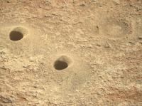
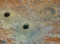
Meanwhile on December 15 NASA published unusually large set of materials in the 'News' section (six or more?) among which the most encouraging (IMHO) is https://mars.nasa.gov/news/9098 named «NASAs Perseverance Mars Rover Makes Surprising Discoveries». The article tells about the unexpected results of the 2-day intensive usage of RIMFAX at the entry of Seitah-S, just after crossing Artuby ridge on sol 200..png/800px-RIMFAX_radargram_at_the_entry_of_South_Seitah_(PIA25025).png)
Posted by: tau Dec 16 2021, 01:23 PM

|
Posted by: tau Dec 16 2021, 02:26 PM
Sol 292 SHERLOC WATSON camera image (with enhanced colors) of a successful abrasion
|
Posted by: Bill Harris Dec 16 2021, 03:42 PM
Phenocrysts!
https://www.cnn.com/2021/12/15/world/perseverance-rover-mars-findings-scn/index.html
Posted by: john_s Dec 16 2021, 03:57 PM
I must admit being surprised by the identification of the "Brac" rocks as volcanic. Their texture looks like a well-sorted, well-cemented, sandstone to me, and the fine layering and persistent dip, seen by RIMFAX and in the images of the Seitah outcrops, is surprising for lavas, particularly as tectonic tilting seems unlikely.
John
Posted by: dburt Dec 16 2021, 05:38 PM
John
Me too, especially given how extremely rich they are in sorted, granular olivine. Olivine-rich, silica-poor lavas (komatiites) typically form from dense, extremely hot magmas and tend to cool quickly, yielding branching dendritic ("spinifex") textures in olivine towards their tops. Fine layering and original dip could be formed in volcanic-pyroclastic or impactoclastic beds, but again the abundance of sorted, granular olivine would be a mystery. Possibly the olivine could be a cumulate deposit that settled out of magma or lava that was still flowing (some cumulates can be bedded), in which case the top could have been eroded off. An interesting mystery, but not one of my areas of expertise.
dburt
Posted by: Bill Harris Dec 16 2021, 06:49 PM
I keep vacillating between "clastic" and "magmatic" as a source for these rocks. I've been ending up back in the pyroclastics camp since we are so close to the Syrtis volcanic province. The mystery here is the persistent presence of sorted, angular olivine "phenoclasts". Fast-cooling ignimbrite would tend to be glassy, so it's possible that we have cumulate deposits. Or, clutching here, an impactoignimbrite base surge (I just constructed a term there) of want of other explanations. Mars is a very unique place.
I'm looking forward to reading some of the papers on this area.
It may even get more "sane" once we arrive at the clear-cut clastic of the deltaic deposits. But who knows what we will find.
--Bill
Posted by: john_s Dec 16 2021, 07:30 PM
The odd thing is that the wording of the press release implies that they think we're seeing primary crystallization textures, directly from a magma, not volcanoclastic or pyroclastic sediments. But yes, Mars is strange...
John
Posted by: tau Dec 16 2021, 09:21 PM
Two sol 291 SuperCam Remote Micro-Imager composite images (one of them with 10 laser holes), and their context from Mastcam-Z and Front Right Hazard Avoidance Camera A.
The smooth surface is presumably some kind of desert varnish.

|

|

|

|
Posted by: serpens Dec 16 2021, 11:17 PM
From the CNN report: "The rover's latest finding suggests that the bedrock it has been driving over since landing was once formed by volcanic lava flows -- something that was "completely unexpected," according to mission scientists."
Prior to landing the The consensus seemed to be that the crater floor was flooded by lava some 300 million years after the lake dried up. This embayed sedimentary/deltaic deposits including the olivine rich Séítah unit. Perseverance's track south and along Artuby ridge skirted Séítah and she didn't cross onto the olivine rich unit until Sol 201. So traversing eroded lava deposits and seemingly some sedimentary deposits since landing would not seem particularly unexpected.
Posted by: HSchirmer Dec 17 2021, 12:57 PM
... So traversing eroded lava deposits and seemingly some sedimentary deposits since landing would not seem particularly unexpected.
Eh, the quality level of consumer journalism has dropped quite a bit - as noted by some reviews of the print version of Time Magazine 's "Person of the Year" edition getting basically ALL the basic rocketry facts about Elon Musk wrong.
Posted by: john_s Dec 17 2021, 06:45 PM
Talking to someone who saw the AGU talk, it seems that the team actually agree that the Seitah rocks are sedimentary. But they contain clasts that they think preserve primary igneous textures. The press release is poorly worded, though, and gives the wrong impression (to me, anyway).
John
Posted by: Phil Stooke Dec 18 2021, 12:10 AM
We have a name for the rock being worked on now: Issole, which was a name used around sol 201.
Phil
Posted by: Bill Harris Dec 18 2021, 03:34 AM
John_s: "...they contain clasts that they think preserve primary igneous textures."
Not to muddy the waters (so to speak), but this is intriguing. To me, this implies a breccia or pebbles in the mix. At least with our close-up imagery, I can't say that I've seen larger clasts. Sometimes these "sandblasted aeolian-eroded surfaces" are challenging to interpret.
In college we had a drawer of rock and mineral specimens cut and polished into perfect 1" cubes, which made it devilish to ID.
--Bill
Posted by: Cherurbino Dec 18 2021, 05:14 AM
Phil
Thank you, Phil, and may I ask you to give the final verification for the pair to Salette (sample 4, sol 262)? On fig. 5 in http://www.unmannedspaceflight.com/index.php?act=attach&type=post&id=49748 to http://www.unmannedspaceflight.com/index.php?showtopic=8661&view=findpost&p=255205 the name for sample 5, sol 271 is dashed, while Dourbes is the name for the full abrasion on sol 253.
Meanwhile the photo of moulages at the counting desk in the JPL headquarters appeared.
.png)
The resolution is lower than may be imagined, but it is the only size available at NASA's catalogue https://photojournal.jpl.nasa.gov/catalog/PIA25026
My guess that the inscription on the last tube says "DOURBES". Am I right?
Posted by: vikingmars Dec 18 2021, 06:00 AM
For your perusal, mosaics showing interesting layered rocks taken Sols 288, 289 and 290. Also in 3D.
=>> Published also as a special tribute to Jim Bell, our dynamic past President (The Planetary Society), his Research Group at ASU, and the wonderful MastCam-Z Team.
Enjoy

|
|
|
Posted by: vikingmars Dec 18 2021, 06:01 AM
(Cont.)

|
|
|
Posted by: vikingmars Dec 18 2021, 06:02 AM
(Cont.)

|
Posted by: vikingmars Dec 18 2021, 06:04 AM
(Cont.)

|
Posted by: vikingmars Dec 18 2021, 06:05 AM
(Cont.)

|
|
|
Et voilà
Posted by: Phil Stooke Dec 18 2021, 07:52 AM
Per VikingMars's request above, here is an updated map of Brac showing the name Coulettes for the second sample.
I'm not sure what the 'partial abrasion' actually was. If anyone can explain it I would like to know. We had that on sol 289 at Issole as well, before the sol 292 abrasion.
Phil

|
Posted by: Saturns Moon Titan Dec 18 2021, 10:54 AM
John
That surprises me because I also watched the AGU talk and got the opposite impression. In Ken Farley's pre-recorded intro talk he went into detail about how the rock they identified in Seitah was a dunite. They showed a plot of 100 supercam measurements from Seitah which all plotted very close to olivine and a supercam zoom of a seemingly in-situ layer which they said showed primary igneous textures. The key evidence was a poikilitic crystal texture they found using PIXL in the Dourbes abrasian at Seitah, where a pyroxene crystal was seen to envelop an olivine. Farley didn't suggest this was a clast. Three possibilities were discussed for how this olivine cumulate formed: at base of a thick lava flow, lava lake, or an eroded intrusion. Personally, I find it hard to explain the obvious layering exhibited by these rocks without at least intervals of sedimentation between lava flows.
Just rewatched Joel Hurowitz's PIXL talk. For both Seitah and CF-Fr they determine the lithology to be primary igneous. a slide from his talk is attatched below.

|
Posted by: HSchirmer Dec 18 2021, 12:28 PM
Well, it's very odd to think about it, but it IS essentially snowing or sleeting mineral crystals INSIDE a magma chamber, and with multiple possible surface vents, you seem to get layering of different 'flavors & consistencies"
See, e.g.
Transmission of Flood Basalts through a Shallow Crustal Sill and the Correlation of Sill Layers with Extrusive Flows:
The Palisades Intrusive System and the Basalts of the Newark Basin, New Jersey, U.S.A.
https://www.jstor.org/stable/10.1086/595663
LINK TO AGU21 Press Conference
NASA’s Perseverance Mars rover has spent the 10 months since its landing exploring two very different geologic units on the Jezero crater floor. After exploring and taking its first two samples from the Crater Floor geologic unit, Perseverance entered Séítah geologic unit in October. The rover has spent the last several months analyzing multiple outcrops of Séítah, allowing the science team to begin to understand the relationship between these unique geologic units and their place in the geologic history of Jezero. What scientific discoveries have Perseverance’s on-board investigations made to date, and what explorations are still to come – in Séítah, and down the road at the crater’s intriguing ancient river delta?
Panelists:
Ken Farley, California Institute of Technology
Sanjeev Gupta, Imperial College London
Briony Horgan, Purdue University
Eva Scheller, California Institute of Technology
Kelsey Moore, California Institute of Technology
https://youtu.be/N0zWp-lR25g
Posted by: john_s Dec 18 2021, 03:06 PM
|
|
OK, I stand corrected (my information was second-hand). But I thus remain quite confused about how to reconcile the fine, tilted, layering and granular texture with a primary igneous unit.
John
Posted by: HSchirmer Dec 18 2021, 03:22 PM
John
As is everyone else!
You see large scale intrusive igneous sills following pre-existing tilted sedimentary rock bedding

In some cases, you seem to see VERY small-scale layering from magma chambers "snow globing"
http://faculty.strose.edu/maess/research.html
Posted by: tau Dec 18 2021, 04:34 PM
Sol 293 combined color/detail image of the sol 292 abrasion patch. Colors are enhanced. The scale may not be entirely accurate.
SHERLOC WATSON camera for color. https://mars.nasa.gov/mars2020-raw-images/pub/ods/surface/sol/00293/ids/edr/browse/shrlc/SIF_0293_0692957360_269EBY_N0090000SRLC00479_0000LMJ02.png.
SHERLOC Autofocus and Context Imager for detail. https://mars.nasa.gov/mars2020-raw-images/pub/ods/surface/sol/00293/ids/edr/browse/shrlc/SC3_0293_0692979624_464ECM_N0090000SRLC11360_0000LMJ01.png.

|
Posted by: Saturns Moon Titan Dec 18 2021, 05:44 PM
Thanks for the information about cumulate textures, HSchirmer. I also watched the press conference you linked, I found that it goes into a satisfying level of scientific detail that you don't usually see at press conferences. The team's excitement about these igneous rocks is very obvious.
Posted by: MichaelT Dec 18 2021, 09:42 PM
Could it be that Percy caught the first ever photos of a halo on another planet on Sol 292 with its navcam? Notice the ring around the sun in the images below?
According to the specifications the field of view of the navcams is 96° x 73°. When I use those numbers I arrive at an angle of about 22.4° for the inner edge of the halo, not considering any lens distortion. That would match really well a typical 22° halo that is one of the most common types of halo here on Earth. Therefore the ring around the sun in the images could be a halo caused by water ice crystals (hexagonal prisms). According to atoptics, CO2 ice crystals would create a halo 26° from the sun (https://www.atoptics.co.uk/halo/owmars.htm).
What do you all think? Have halos been imaged on Mars before?
Michael

|

|

|
Posted by: fredk Dec 18 2021, 10:14 PM
Nice catch. Those don't look like lens reflections or colour banding due to low bit depth, so might be a real halo. There've been suggestions of halos before but nothing confirmed, see http://www.unmannedspaceflight.com/index.php?showtopic=8525&st=600&p=250552&#entry250552
Posted by: serpens Dec 18 2021, 11:32 PM
Just wondering whether this may be a swarm of inclined sheets from a shallow magma chamber with periodic replenishment. The primary release from the main reservoir being elsewhere, for example the anomalous high elevation cone just outside the south east rim of Jezero.
Posted by: JTN Dec 19 2021, 12:43 AM
https://twitter.com/DDAVISSPACEART/status/1471823686332157953
Posted by: Julius Dec 19 2021, 12:46 AM
This Seitah region must have been buried under the delta at some point and exposed by erosion?
Posted by: tdemko Dec 19 2021, 01:03 AM
John
I'm also very confused. Layered igneous complexes form within the crust of planets, at least a few kms below the surface (all the talk about slow cooling, cumulate textures, mineralologic/density stratification, etc.). The dipping Seitah rocks are now at the surface. Where did all of the roof rocks above the magma chamber go? The original floor of the crater is far below the current surface, mantled by the crater fill. If this supposed layered igneous complex was intruded into crater fill, how did it get excavated down to the intruded depth, and how did that material exit the crater? And intercalated lava flows ?!?! None of this makes any geologic sense, and as far as I can see hinges on the relationship within one multi-mineral grain/phenocryst that shows an intergrown igneous texture between one crystal of olivine and some pyroxenes in a highly altered rock on an abraded surface.
My kingdom for a thin section and some crossed polars!
I can see why there still may be a contingent of investigators that may be carrying a volcaniclastic or reworked igneous/volcanic sedimentary origin. I certainly am. The "smoking gun phenocryst" could be a multi-mineral grain/clast in a coarse/granule sandstone. There could be a mafic igneous complex exposed in the uplifted crater rim bedrock that supplied these grains to a sedimentary transport system that contributed to the crater fill.
PS: I taught at University of Minnesota Duluth, which literally is on the Duluth Complex, one of the best known layered igneous complexes on Earth. I've led many field trips to Duluth Complex outcrops (including the famous "sedimentary" layering and "crossbedding"), as well as the volcanic and sedimentary rocks which overly the intrusion.
https://en.wikipedia.org/wiki/Duluth_Complex
Posted by: Bill Harris Dec 19 2021, 02:06 AM
Good post, Tim. In true Rover fashion, we are getting data and imagery in spurts, which can lead to speculation and arm-waving. I'm bad about seeing something and working up an interpretation only to get another "dribble of data" and revise the model. Arm-Waving at it's finest, as long as it doesn't morph into a rant!
No matter what, this will be a wondrous area to examine. We are making our way back to the landing point, and then westward towards the delta units. I'm looking forward to moving up in the current section, but moving slowly and not rushing things.
--Bill
Posted by: PaulH51 Dec 19 2021, 06:38 AM
Latest sample site from Jezero sol 295. The rock is named 'Issole', we don't appear to have a name for the abrasion or the core yet (AFAIK)
4-tile R-Navcam (using MS-ICE) and a L-Mastcam showing the core in the drill.

|

|
Posted by: serpens Dec 19 2021, 07:02 AM
It is hard to believe that they would take so many samples from what would effectively be a sterile unit.
Posted by: Saturns Moon Titan Dec 19 2021, 10:24 AM
Initially I was also quite alarmed as I think this new sample pair will push us past 1/4 of the samples already 'used up'. However it's easy to forget we're a full 10 months into the mission already, so actually it works out, at this rate we'll have used all the sample tubes up in ~3 years but that's the length of the prime mission. They always said they planned on depositing the first sample cache somewhere safe inside the crater at the end of the prime mission, just before they leave Jezero for good. It seems they actually intend to stay on-track with their timeline, so maybe by 2024 we really will be out the crater and driving away.
These rocks are clearly of great scientific value of course, as here we are 10 months later still confused by them. Radiometric dating will be a major motivation. Still it's not clear to me why 3 samples of Seitah are needed. I wouldn't call this unit effectively sterile - if it does indeed pre-date the delta then groundwater from the lake above has circulated through these rocks. The minor salt, carbonate and silica phases prove that aqueous alteration occured at some point, and these could preserve biosignatures.
Posted by: HSchirmer Dec 19 2021, 01:20 PM
(snip
I can see why there still may be a contingent of investigators that may be carrying a volcaniclastic or reworked igneous/volcanic sedimentary origin.
(snip)
...the maximum temperature decrease along the flow axis of the Ginkgo is 20 °C, suggesting cooling rates of 0.02–0.04 °C/km. These cooling rates ... allow emplacement either as a fast laminar flow under an insulating crust or as a slower, inflated flow. https://pubs.geoscienceworld.org/gsa/geology/article-abstract/25/5/403/206646/Temperature-constraints-on-the-Ginkgo-flow-of-the
Second mind blowing idea, estimated flow speed for Ginko flood basalt was 3-30 kph(2-28 mph)! Jezro resurfacing by laminar flow could 'crêpe' over the crater in less than 90 minutes to 15 hours!
Third, an excellent point by tdemko that debris or flowing liquids act REALLY weird. So, makes sense for some "flowing stuff' (water or lava) to entrain ash and create weird forms. It IS interesting how floodwaters with debris/ice/snow can form 'self levelling debris jams' which push out and across the landscape in ways that don't make sense.
https://youtu.be/_yCnQuILmsM?t=197
Posted by: JRehling Dec 19 2021, 04:50 PM
Without any geological expertise, but noting the confusion of those who have it, I note, by analogy, that sometimes a really strange accounting discrepancy is due to two errors in opposite directions.
Is it possible that Jezero has seen one more cycle of deposition and then removal by erosion than the simpler explanations that we started with? Then perhaps the things on the surface that seem like they should have taken place underground actually did take place underground, and have since been exhumed.
Posted by: PDP8E Dec 19 2021, 07:26 PM
SOL 294 -- 15 images, 360 Pan, (no DDs) but here is the pan ...
|
|
Posted by: Phil Stooke Dec 20 2021, 07:54 AM
https://twitter.com/NASAPersevere/status/1472817177086468097
The sample is called Robine.
Phil
Posted by: tau Dec 23 2021, 08:14 PM
Here is an attempt to outline some minerals in the Dourbes abrasion patch from sol 253.
The background image is an overlay of sol 257 images from the SHERLOC Autofocus and Context Imager (for detail) and the SHERLOC WATSON camera (for color, enhanced).
The boundaries between different minerals are hardly recognizable in the photos because the crystals have a crushed surface by the hammering abrasion tool.
The discussed olivine crystal, surrounded by pyroxene, is to the left of the center of the image. Pyroxene appears bluish here. Olivine looks very heterogeneous.

|
Concerning the minerals, following PIXL results were used:
https://www.jpl.nasa.gov/images/pia25041-pixls-view-of-dourbes . http://www.unmannedspaceflight.com/index.php?act=attach&type=post&id=49954 See also http://www.unmannedspaceflight.com/index.php?showtopic=8661&view=findpost&p=255536.


Posted by: john_s Dec 23 2021, 08:35 PM
Thanks- very useful to see that correlation!
John
Posted by: PDP8E Dec 23 2021, 10:33 PM
SOL 299 -- 15 images, 360 Pan, (no DDs) -- here is the PAN -- 4:25 PM -- low sun angle
|
|
Posted by: Bill Harris Dec 23 2021, 10:44 PM
Thanks for that analysis of the mineralogical makeup of this specimen. It narrows down the origin of this rock quite a bit.
--Bill
Posted by: tau Dec 25 2021, 05:57 PM
Sol 299 SuperCam Remote Micro-Imager with context images from sol 299 Mastcam-Z (with anaglyph) and sol 294 Navcam.
The SuperCam image is distorted in the context images because of parallax between SuperCam, Mastcam-Z, and Navcam.
The distance to the SuperCam target is about 21 m in the northwest direction.

|

|

|

|
Posted by: PDP8E Dec 25 2021, 06:42 PM
SOL 301 DD Pan -- 1:45 PM
|
|
Posted by: tau Dec 27 2021, 11:38 AM
John
Many of the outlines and all the mineralogical interpretation in the first image of my post #138 are based on the two images with PIXL results, hence the good correlation.
It is hardly possible to identify the individual minerals just from the photos (even more so because I am not a mineralogist).
The photos only helped to better delineate some of the crystals/grains, especially the bluish appearing pyroxene, the white sulfate and the small dark blue Fe-mineral grains.
It was not possible to distinguish olivine and feldspar in the photos, and there are some bluish parts in the olivine which look like pyroxene by color.
Here is an animated overlay of the SHERLOC and PIXL images.

|
Posted by: vikingmars Dec 28 2021, 06:38 AM
|
|
Thanks a lot PDP8E for this nice panoramic picture: the clouds are indeed very spectacular!
Posted by: tau Dec 28 2021, 02:32 PM
Sol 302 Mastcam-Z
1. Right eye filter 0 (RGB) raw image
2. Left eye filters 1 to 6 multispectral principal components
3. Right eye filters 0 to 6 multispectral principal components
1

|

|

|
Posted by: PaulH51 Dec 30 2021, 09:20 PM
Sol 306: We have a new sample in the drill acquired from the rock outcrop named 'Issole'!
The new cored hole can be seen next to 'Robine' in this 4-tile NavCam that I have roughly assembled in MS-ICE. The core was imaged by the L-MastCam-Z (a jpeg version of the image is uploaded)

|

|
Posted by: tau Dec 31 2021, 05:15 PM
Investigation of a finely textured rock coating (desert varnish?) on sol 305 with SuperCam Remote Micro-Imager and laser (at least 3 laser holes in the coating).
Context images from sol 305 Mastcam-Z and sol 303 Navcam.

|

|

|
Posted by: charborob Jan 3 2022, 01:22 AM
Sol 308 LMastcam-Z:
|
|
Posted by: tau Jan 3 2022, 06:33 PM
Sol 306 SuperCam Remote Micro-Imager (in this case rather a "Remote Tele-Imager") with a Mastcam-Z context image from sol 304, and the same Mastcam-Z image with enhanced contrast and colors .
There seems to be a slightly raised rim around the outcrop of the bright patchy sediment, and a faintly visible thin dark line (a layer boundary?) behind the bright sediment from the middle of the SuperCam image to the left.

|

|

|
Posted by: tau Jan 3 2022, 06:40 PM
Sol 308 SuperCam Remote Micro-Imager.
Mastcam-Z context images from sol 288 with 110 mm focal length and sol 308 with f=34 mm (raw and enhanced with special attention to the distant part of the landscape).

|

|

|
Posted by: tau Jan 4 2022, 01:32 PM
Addendum to post #150
The http://www.unmannedspaceflight.com/index.php?act=attach&type=post&id=50045 seen from orbit by https://www.uahirise.org/ESP_062530_1985 (JP2 Black and white map-projected, 889 MB),
and a part of the http://www.unmannedspaceflight.com/index.php?act=attach&type=post&id=50047 transformed to approximately match the HiRISE photo.
At the boundary between the smooth unit (bright, downhill to the right) and the rugged crater rim unit (uphill to the left) there is indeed a rim.
Could it be that the smooth unit is younger but firmer, leaving solid material on the erosion front between the two units to form the rim?

|

|
Posted by: tau Jan 4 2022, 02:51 PM
Second addendum to post #150
A broader context for the sol 306 SuperCam RMI target in an enhanced Mastcam-Z image from sol 282

|
Posted by: vikingmars Jan 4 2022, 05:39 PM
A broader context for the sol 306 SuperCam RMI target in an enhanced Mastcam-Z image from sol 282
Thanks so much Tau for this superb work of yours
Posted by: serpens Jan 5 2022, 01:40 AM
Concur.
Posted by: Bill Harris Jan 5 2022, 02:57 AM
Agree.
That image in post153 reminds me I'd Death Valley!
Posted by: Bill Harris Jan 5 2022, 03:03 AM
(snip)
My initial impression of this spot is that it is (aeolian) weathering of a less-resistant area.
--Bill
Posted by: charborob Jan 6 2022, 07:07 PM
Sol 312 anaglyph:

|
Posted by: tau Jan 6 2022, 08:44 PM
Sol 312 SuperCam Remote Micro-Imager with Mastcam-Z and Navcam context

|

|

|
Posted by: PaulH51 Jan 7 2022, 11:54 PM
Looks like we have a couple of pieces of Mars (rock core) that fell out of Perseverance's drill bit / tube, while it was being placed into the bit exchange mechanism in the rover's carousel that's located on the deck.
This will likely prevent changing bits and processing samples until they can be safely removed.
This heavily processed image is from the rover's Watson camera acquired on sol 314

|
EDIT
Mission update issued by the team https://mars.nasa.gov/mars2020/mission/status/356/assessing-perseverances-seventh-sample-collection/ and a nicely processed image

|
Posted by: Explorer1 Jan 8 2022, 08:45 PM
Blog post here with more details: https://mars.nasa.gov/mars2020/mission/status/356/assessing-perseverances-seventh-sample-collection/ Next week they will try to get them out.
Posted by: tau Jan 9 2022, 03:05 PM
Sol 315 SuperCam Remote Micro-Imager with Mastcam-Z context, showing a cliff of layered delta sediments.
Compared to a https://mars.nasa.gov/mars2020-raw-images/pub/ods/surface/sol/00282/ids/edr/browse/zcam/ZL0_0282_0691957753_863EBY_N0080410ZCAM08301_0340LMJ02.png, the air appears to be more dusty now.
Is that just a big broken off slab of rock under the cliff or an unconformity?

|

|
Posted by: tau Jan 9 2022, 05:35 PM
While the air was quite dusty and hazy on sol 315, it cleared up on sol 316.

|
Posted by: tau Jan 9 2022, 07:49 PM
Delta sediments in a sol 316 SuperCam RMI image with a sol 315 Mastcam-Z context (see also the right part of the context image in post #162)

|

|
Posted by: vikingmars Jan 9 2022, 10:47 PM
Sol 313 NavCam images showing the Martian sky duly processed: it was a very cloudy day indeed ! And those are rare events on Mars. Enjoy

|

|
Posted by: serpens Jan 10 2022, 11:18 AM
Given the haze obscuring the hills in the background could this be dust?
Posted by: tau Jan 11 2022, 11:31 AM
Various grains in a sol 315 SuperCam RMI photo mosaic.
At first I was puzzled why the overlapping parts of the individual images fit together so badly.
Then I found out that many grains changed orientation or moved between the takes (time intervals 10 to 13 minutes).
So a grain with a dimple can be seen twice in the SuperCam photo mosaic (arrows). Here is also an animation for this.
Did we have windy weather on sol 315? What does the weather report say?
|
|
|
Posted by: charborob Jan 11 2022, 12:07 PM
Sol 317 anaglyph:

|
Posted by: tau Jan 11 2022, 03:20 PM
Sol 317 SuperCam Remote Micro-Imager with Mastcam-Z context and Mastcam-Z left eye filters 1 to 6 multispectral principal components
|

|
|
Posted by: Ant103 Jan 12 2022, 11:41 AM
It think it's more of a dusty day Olivier
See the full panorama taken on Sol 313, especially the mountains under the Sun. Big patch of sand were blown away.
https://db-prods.net/marsroversimages/Perseverance/2022/Sol313_pano.jpg
3 sols later. A more homogenous sky, suggesting the dust load has risen since.
https://db-prods.net/marsroversimages/Perseverance/2022/Sol316_pano.jpg
(And a pretty sunset on Sol 318)
https://db-prods.net/marsroversimages/Perseverance/2022/Sol318_Mastcam34.jpg
Posted by: tau Jan 12 2022, 01:09 PM
More evidence of a presumed short-lived dust storm on day 315.
Sol 316 Hazcam: The lens of the Rear Right Hazard Avoidance Camera (Hazcam) is apparently covered with orange dust. Hopefully, this will not complicate hazard avoidance.
Sol 318 Mastcam-Z image: The rim of the drilling powder was partially blown away, and granular material was accumulated in the abrasion patch (raw image and enhanced).
Judging from the image, the wind or storm came from an easterly direction.
See also http://www.unmannedspaceflight.com/index.php?showtopic=8661&view=findpost&p=255825 (hazy atmosphere) and http://www.unmannedspaceflight.com/index.php?showtopic=8661&view=findpost&p=255852 (displaced sand grains).

|
|
|
Posted by: Bill Harris Jan 12 2022, 07:07 PM
Tau, this is another good demo of aeolian transportation in action. It acts long-term and shorr-term.
Posted by: tau Jan 13 2022, 07:28 PM
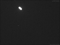
Sol 319 evening images of Phobos by Mastcam-Z.
Sun and stars appear to rise in the east and set in the west, the opposite is true for Phobos. It rises in the west and moves rapidly east about twice a day.
The opposite apparent motion of Phobos and two stars can be seen in this animation. View direction is southwest. Time is local mean solar time.
The track of Phobos is overexposed, but the night side of Phobos can be seen to the left of the track, illuminated by light reflected from Mars.
|
Posted by: fredk Jan 14 2022, 12:28 AM
The performance of MZ at night looks similar to MSL mastcam, as expected. Here's a stack of two differenced images, where the differencing removes most of the noise:

|
The field is in UMa, including the famous eyesight-tester pair of Alcor and Mizar at bottom. The stars are, of course, trailing in a weird direction, for those familiar with Earth's sky.
Posted by: Ant103 Jan 14 2022, 07:51 PM
Sol 320 MastcamZ panorama. Look at the rover tracks, partially erased from the Sol 312 wind blow
https://db-prods.net/marsroversimages/perseverance2022.php#4
Posted by: tau Jan 14 2022, 10:24 PM
Sol 316 Mastcam-Z landscape with delta cliffs (enhanced colors and contrast, anaglyph)
|
|
Posted by: tau Jan 14 2022, 10:28 PM
Sol 320 SuperCam Remote Micro-Imager with Mastcam-Z context
|
|
Posted by: tau Jan 14 2022, 10:32 PM
Another sol 320 SuperCam Remote Micro-Imager with sol 289 Mastcam-Z context
|
|
Posted by: Phil Stooke Jan 16 2022, 12:56 AM
This is my circular pan of the current area with three nearby features identified.
Phil
|
Posted by: vikingmars Jan 16 2022, 09:37 AM
Bravo Damia for this very nice panoramic image.
And also for the nice 360° sky images and the sunset pan!

Posted by: Ant103 Jan 16 2022, 11:48 AM
Merci Olivier Coming from you, this means a lot !
Posted by: tau Jan 17 2022, 10:25 AM
Sol 320 SuperCam Remote Micro-Imager shows the effect of a laser beam on the rock surface
1. Animation before and after impact of the laser beam
2. After impact
3. Difference image after-before. The small black dot in the center is the actual laser hole.
The dust on the rock surface was blown aside by the small explosion in the dark area with a radius of about 4 mm.
Some of the removed dust (light and reddish brown in this image) has accumulated ouside of the affected area.
4. Mastcam-Z context
1

|

|
|

|
Posted by: tau Jan 17 2022, 02:47 PM
Sol 322 SuperCam Remote Micro-Imager with Mastcam-Z context and again with remnants of those enigmatic coatings.
See also post #146 from sol 203 with two multispectral false-color images, where the coatings stand out in a different color from the bluish rock.

|

|
Posted by: Bill Harris Jan 17 2022, 10:04 PM
See also [snip]
I'm looking forward to the point when we have discussions from the investigators on the nature of this enigmatic coating. Has there been been any word on their composition from the Laser Zaps?
"Desert varnish" is one term I hear to describe them, but that is loaded because it has a specific meaning. I whimsically refer to them as "bird droppings", which is also incorrect. But they do have a curious drip-and-flow pattern to some patches.
--Bill
Posted by: serpens Jan 17 2022, 11:42 PM
The feature seems restricted to specific layers, almost as though it is the remnants of interaction with a fine sedimentary deposit during formation.
Posted by: tau Jan 18 2022, 10:34 AM
Concerning the coatings, here is a link to a https://www.nationalgeographic.com/science/article/mysterious-purple-coating-found-on-mars-rocks, with links to two abstracts of the AGU Fall Meeting.
https://agu.confex.com/agu/fm21/meetingapp.cgi/Paper/989148
Citation: "LIBS chemistry data indicate the surface may be relatively enriched in Mg, Mn, Cr, and possibly H, whereas the interior [of the coating or of the rock?] was relatively enriched in Si, Al, and Sr."
https://agu.confex.com/agu/fm21/meetingapp.cgi/Paper/989677
Citation: "Mastcam-Z multispectral data in the visible/near-infrared (VNIR; 440-1100nm) indicate these purple areas commonly display a narrow absorption band near 860 nm, possibly consistent with both fine-grained crystalline hematite and poorly crystalline iron oxides."
Unfortunately, there is free access only to the abstracts.
The particular color of the coatings in some images reminds me of a pigment called "caput mortuum", chemically Fe2O3. It is produced by strong heating of pyrite/marcasite or of ocher (hydrated iron oxide).
Posted by: tau Jan 18 2022, 03:16 PM
Sol 323 SuperCam Remote Micro-Imager no. 1 with sol 298 Mastcam-Z context

|

|
Posted by: tau Jan 18 2022, 03:18 PM
Sol 323 SuperCam Remote Micro-Imager no. 2 with sol 298 Mastcam-Z context

|

|
Posted by: serpens Jan 19 2022, 01:59 AM
The links to analysis of coatings in Tau's post refer to the dark coatings as imaged in his post #148. The recent images of beige coloured coatings seem to be a different beast. Thanks for your detailed images Tau.
Posted by: Bill Harris Jan 19 2022, 03:40 PM
Sounds like a typical desert varnish thus far.
Caput mortium? "Dead head". That's too much!
--Bill
Posted by: tau Jan 19 2022, 05:19 PM
Sol 315 and 323 SuperCam RMI mosaic.
What looks at first glance like a big broken off slab of rock lying on the talus, is even bigger than it seems without a scale.
By linking SuperCam RMI images, a HiRISE orthomosaic, and a HiRISE digital terrain model with control points, the dimensions of the scene could be calculated.
As a scale, a "marsonaut" (1.8 m tall) was inserted into the picture.
My presumption: It is not a broken off slab of rock, but the surface of layers that dip at an angle of 30° (foreset layers?).
Inset: a profile perpendicular to the cliff face.

|
Posted by: kymani76 Jan 19 2022, 09:23 PM

|
Spectacular images tau! 3D render of the above scene with Perseverance on top of the cliff for scale.
Posted by: Ant103 Jan 20 2022, 03:12 PM
Sol 321 Navcam panoramic
https://db-prods.net/marsroversimages/Perseverance/2022/Sol321_pano.jpg
Same, but with sky. I dreamt of it since years ! And it's done. But I still getting issues with the differences between the frames.
https://db-prods.net/marsroversimages/Perseverance/2022/Sol321_pano_sky.jpg
Posted by: tau Jan 20 2022, 05:22 PM
A second image series of the delta cliff by SuperCam RMI on sol 325, now with better visibility of the stratification due to a more favorable incidence of sunlight (solar elevation 68°) and a less dusty atmosphere than on sol 315.
On sol 315, the solar azimuth of 173° was perpenticular to the cliff face, but the sun was high in the sky (solar elevation 82°) causing more shadows by protruding parts of the cliff.
Taking into account geometry, shadows, and sun's position on sol 315, the part above the "marsonaut" protrudes about 1.7 m from the cliff (a very rough calculation due to the irregular shape of the cliff face).
Corresponding features in the SuperCam mosaic and in the HiRISE map are marked with letters.

|

|
Posted by: Bill Harris Jan 21 2022, 02:11 AM
On the pebble-clogged sampling bit carousel:
https://phys.org/news/2022-01-perseverance-dumps-contents-sample-tube.html
Posted by: djellison Jan 21 2022, 05:22 AM
Just a literal copy and paste of https://mars.nasa.gov/mars2020/mission/status/357/pebbles-before-mountains/
Posted by: Zelenyikot Jan 21 2022, 01:15 PM
Carousel debris on the ground

|

|
Posted by: Zelenyikot Jan 21 2022, 01:17 PM
Carousel is free!

|
Posted by: Explorer1 Jan 21 2022, 07:25 PM
Yes, all clear! https://mars.nasa.gov/mars2020/mission/status/359/ejecting-mars-pebbles/
The article also includes a surprisingly neat gif off the pebbles tumbling out in the 0.38 G to the surface.
Posted by: PaulH51 Jan 22 2022, 10:55 AM
A couple of 4-tile NavCam's after a short drive on sol 328 (roughly assembled in MS-ICE)
Both show a sand covered deck.

|

|
Posted by: Ant103 Jan 22 2022, 03:31 PM
I implemented an immersive version of my 321 panorama on my website :
https://db-prods.net/marsroversimages/galerie_immersive.php
Posted by: vikingmars Jan 22 2022, 05:35 PM
Same, but with sky. I dreamt of it since years ! And it's done. But I still getting issues with the differences between the frames.
What a great work and such great images ! Yes indeed, we dreamed to see such full pans made with real images (with no added artificiel sky) from -90° to + 90° since the Viking times !
Congratulations Damia
Posted by: Phil Stooke Jan 23 2022, 08:14 AM
Sol 328, a small move to the southeast. Perseverance was facing the rocky ledge it sampled, but it has turned away from the ledge and moved so it is facing away from it.
My image combines images to maximize viewing of the surface, not the rover, so the antenna at the back end is not visible. There was also a missing quadrant in one frame.
Phil

|
Posted by: tau Jan 23 2022, 05:11 PM
Sol 323 Mastcam-Z multispectral image series no. 1
1. Left eye filter 0 (RGB) raw image.
2. Left eye filters 1 to 6 principal components false colors.
3. Right eye infrared filters 1 to 6, first two principal components. The first component is mainly the illumination.
The second infrared component differentiates between two rock types. Most rocks with a bluish-gray false color are layered and angular. Rocks that appear yellow-brown have often a more rounder shape and vesicles.
The third principal component consists predominantly of flatfield inhomegeneities and therefore is omitted. All other components are mainly image noise.
1

|

|

|
Posted by: tau Jan 23 2022, 05:14 PM
Sol 323 Mastcam-Z multispectral image series no. 2
Explanation as in the previous post.
1

|

|

|
Posted by: tau Jan 23 2022, 05:16 PM
Sol 325 Mastcam-Z multispectral image series
Explanation as in the previous post.
1

|

|

|
Posted by: vikingmars Jan 23 2022, 08:12 PM
My image combines images to maximize viewing of the surface, not the rover, so the antenna at the back end is not visible. There was also a missing quadrant in one frame.
Phil
Thank a lot Phil ! This is a great work indeed
Posted by: serpens Jan 24 2022, 03:15 AM
Nice work Tau. Your post #206 seems to show a change in deposition with thin layering overlaid by blocky.

|
Posted by: tau Jan 26 2022, 03:16 PM
Sol 331 SuperCam Remote Micro-Imager with Mastcam-Z context and left eye filters 1 to 6 multispectral principal components

|

|

|
Posted by: tau Jan 26 2022, 04:04 PM
A delta cliff in a long-baseline stereo anaglyph compiled by Mastcam-Z images from sol 200 and 208 (see also SuperCam RMI mosaics of the cliff in post #191 and post #194).
If there is too much ghosting and cross-talk of the left and right eye channels in the shadows of the cliff in the first image due to a limited color space of the monitor, the second image might work better.

|

|
Posted by: tau Jan 26 2022, 04:07 PM
Sol 328 SuperCam Remote Micro-Imager of delta cliffs with a "marsonaut" for scale and a sol 308 Mastcam-Z context.
The images were aligned horizontally.
The layered outcrops to the right on the talus have a dip angle of at least 20° or more, depending on how they are cut at the surface.
|
|
Posted by: tau Jan 26 2022, 04:10 PM
Sol 331 SuperCam Remote Micro-Imager of layered delta (or river) sediment outcrops with two "marsonauts" for scale and a sol 308 Mastcam-Z context.
The images were aligned horizontally.
The distant marsonaut stands at a small crater on the inner wall of the Jezero crater.
|
|
Posted by: Phil Stooke Jan 28 2022, 03:23 AM
Sol 333, a small drive up onto the ledge, now facing the sampled block for another attempt.
Phil
|
Posted by: PaulH51 Jan 29 2022, 09:05 AM
A small readjustment on sol 335: 4-tile NavCam's assembled in ICE - Raw colours
|
|
|

|

|
Posted by: tau Jan 30 2022, 12:26 PM
A compilation of SuperCam RMI images of the delta cliffs from sol 306 to sol 331 in a Mastcam-Z context panorama and a HiRISE map.
Areas not visible from the rover position are grayed out in the HiRISE map. The contour interval is 2 m.

|
|
Links to individual high-resolution SuperCam mosaics and posts:
(Note: the first six mosaics are not rotated to the horizontal)
sol 306 http://www.unmannedspaceflight.com/index.php?act=attach&type=post&id=50045 / post #150 (no cliff)
sol 315 http://www.unmannedspaceflight.com/index.php?act=attach&type=post&id=50108 / post #162
sol 316 http://www.unmannedspaceflight.com/index.php?act=attach&type=post&id=50112 / post #164
sol 320 http://www.unmannedspaceflight.com/index.php?act=attach&type=post&id=50162 / post #177
sol 323 no. 1 http://www.unmannedspaceflight.com/index.php?act=attach&type=post&id=50224 / post #187
sol 323 no. 2 http://www.unmannedspaceflight.com/index.php?act=attach&type=post&id=50226 / post #188
sol 315+323 http://www.unmannedspaceflight.com/index.php?act=attach&type=post&id=50232 / post #191
sol 325 http://www.unmannedspaceflight.com/index.php?act=attach&type=post&id=50240 / post #194
sol 328 http://www.unmannedspaceflight.com/index.php?act=attach&type=post&id=50296 / post #211
sol 331 http://www.unmannedspaceflight.com/index.php?act=attach&type=post&id=50298 / post #212
Posted by: Phil Stooke Jan 30 2022, 10:15 PM
Tau, your work is amazing and very useful.
Sol 335, moving to get a better position for sampling.
Phil
|
Posted by: charborob Jan 31 2022, 02:59 AM
Sol 333 Lmastcam-Z:
|
|
Posted by: tau Jan 31 2022, 03:44 PM
Thank you, Phil, for your motivating and encouraging words.
On sol 337, the third coring attempt on the same rock appears to have been successfully completed:
|
Posted by: PaulH51 Feb 3 2022, 01:04 PM
Looks like a long drive on sol 340
4-tile NavCam looking back after the drive
The low sun caused a few exposure issues, but I still like the resulting mosaic (roughly assembled in MS-ICE)
|
Posted by: tau Feb 3 2022, 01:37 PM
The third drill hole seen by Mastcam-Z on sol 339
1. Left eye f = 110 mm filter 0 (RGB) raw image
2. Left eye filters 1 to 6 principal components false colors
3. Right eye filters 1 to 6 (infrared) principal components false colors
Interestingly, the drill tailings of the hole drilled on sol 306 have changed their multispectral color (dust from the dust storm?, aging of fresh surfaces?)
4. f = 34 mm anaglyph with discarded pieces of the second core
1 .
|
|
|
|
Posted by: Phil Stooke Feb 4 2022, 01:09 AM
Sol 340, the long drive Paul mentioned brings us to this spot. This could be the longest drive of the mission so far but I won't speculate about the exact length.
This panorama was very tricky. I don't really have time to do this but it's addictive.
Phil
|
Posted by: PaulH51 Feb 4 2022, 01:51 AM
JSON and GeoJSON are now reporting the length as 237.78 meters, so looks like a Mars rover record.
What is the longest drive on the Moon? Is it a solar system record?
Glad you still find time to do those circular pans, all I can do is the 5 individual NavCam 4-tile mosaics, the 360 pan is way beyond my skillset...
This panorama was very tricky. I don't really have time to do this but it's addictive.
Phil
Posted by: Phil Stooke Feb 4 2022, 03:27 AM
The longest drive on the Moon is tricky because the situations are in no way comparable. Strictly speaking I suppose the longest single uninterrupted drive was from the Apollo 17 lunar module to Station 2 at South Massif on EVA 2, driven by a human (Gene Cernan). For a robotic rover it was 3000 m (approx) during a single work shift for Lunokhod 2, driven using a live TV signal (slow scan but still live). Mars rover drives are all pre-programmed, though Perseverance is making use of advanced autonavigation software which must have been used here. The longest drive in a single sol on Mars before this was 220 m on sol 410 of Opportunity's mission. So this is a new record for Mars.
Phil
Posted by: Bill Harris Feb 4 2022, 04:56 AM
This panorama was very tricky. I don't really have time to do this but it's addictive.
Phil
Interesting that the tracks have a "reflective glint" to them. This impresses me as unusual for Mars. I've seen this on the Moon where the Buggy or Rover compresses the Fairy Castle Structure of the regolith.
--Bill
Posted by: Bill Harris Feb 4 2022, 05:02 AM
What is the longest drive on the Moon? Is it a solar system record?
I'm looking looking forward to seeing a map position and also getting a LOS connection with Ingenuity again.
--Bill
Posted by: Bill Harris Feb 4 2022, 05:21 AM
Interestingly, the drill tailings of the hole drilled on sol 306 have changed their multispectral color (dust from the dust storm?, aging of fresh surfaces?)
snipped
Interesting observation about the drill cutting's color change, and a good question. Is it dust accumulation or chemical weathering? I don't see, off the top of my head, weathering in a few days in this dry, cold and anoxic environment.
Again, useful imaging technique.
--Bill
Posted by: serpens Feb 4 2022, 08:41 AM
The Martian atmosphere is a desiccant and there is a possibility that the color change is due to dehydration in the powdery fines. While Olivine is nominally anhydrous it can include low levels of OH ions or water molecules. If there has been a change in the characteristics of the spectral reflectance of the fines, dehydration is the only thing I would think could occur in such a short timeframe.
Posted by: PaulH51 Feb 4 2022, 12:56 PM
another long drive on sol 341:
This end-of drive 4-tile NavCam mosaic looks like it's captured the tracks at the end-of drive on sol 175 at the 'Artuby' outcrop

|
EDIT: Another record drive! distance 240.73 m, bringing the odometer to 3330.78 m
Pity we don't get the drive duration reported in the JSON data, or the in-drive images
Posted by: Bill Harris Feb 4 2022, 02:04 PM
Good possibility. In other words, this other novel process being added to the mix is grinding the rock constituents to a very fine powder during the coring, and allowing this un-normal mixture to react and dehydrate for a few days. I don't recall seeing this color change before.
--Bill
Posted by: Deimos Feb 4 2022, 03:14 PM
Is what was left behind when the wind blew the pile away known to be the same color as what was blown away? Maybe fines vs. coarse grains of the same thing look different, or there is a depth (or lateral?) variation. Maybe compaction matters (none on the left vs. near-equilibrium shape on the right)? I am not denying it could be chemistry--just saying there are clear differences in physical properties and it is difficult to uniquely blame chemical weathering. (Disclaimer: I have no expertise in physical or chemical weathering--or borehole science.)
Posted by: stevesliva Feb 4 2022, 06:24 PM
My hypothesis: any powder under a positive phase angle will apparently brighten as it settles.
Posted by: PaulH51 Feb 5 2022, 01:46 PM
A much shorter drive on Sol 342
4-tile Navcam acquired after the drive and assembled in MS-ICE [2550x1914]

|
Posted by: Bill Harris Feb 5 2022, 06:43 PM
snip
This may be something to keep an eye on the next few years.
--Bill
Posted by: Bill Harris Feb 5 2022, 06:44 PM
The light-toned tracks?
--Bill
Posted by: djellison Feb 6 2022, 12:40 AM
The photometric effects of powdery things are quite strange. Try it with a small pile of cornflower and a torch. Compacted, a little bit, it can end up both darker and brighter dependent on phase angle, how well it compacted etc.
Posted by: serpens Feb 6 2022, 05:50 AM
True, but the effect also shows in the scattering of powder away from the pile.
Posted by: PaulH51 Feb 6 2022, 11:24 AM
Another short drive on sol 343 takes the rover up onto Artuby. The next sampling site?
End-of-Drive NavCam (4-tile, assembled in MS-ICE)

|
Posted by: Phil Stooke Feb 7 2022, 12:30 AM
Catching up... this is sol 341.
Phil

|
Posted by: Phil Stooke Feb 7 2022, 04:24 AM
And sol 342.
Phil

|
Posted by: Phil Stooke Feb 8 2022, 01:16 AM
And 343. Up to date!
Phil

|
Posted by: tau Feb 8 2022, 08:37 PM
Investigation of a rock coating (desert varnish?) at Artuby East
1. SuperCam Remote Micro Imager on sol 345
2. Mastcam-Z context with focal length = 110 mm on sol 343
3. Mastcam-Z context with focal length = 34 mm on sol 344
4. SHERLOC WATSON camera on sol 345. There are at least 9 laser holes in this image.
1

|

|

|

|
Posted by: Bill Harris Feb 9 2022, 01:07 AM
snip
It is exciting that they have been examining the enigmatic "desert varnish" during this phase.
And it seems to me that the grain size/distribution has changed in this part of Artuby.
--Bill
Posted by: Phil Stooke Feb 9 2022, 09:29 PM
A new abrasion:
https://mars.nasa.gov/mars2020-raw-images/pub/ods/surface/sol/00346/ids/edr/browse/shrlc/SIF_0346_0697661611_539EBY_N0092982SRLC00758_0000LMJ01_800.jpg
https://mars.nasa.gov/mars2020-raw-images/pub/ods/surface/sol/00346/ids/edr/browse/fcam/FRF_0346_0697660199_987EBY_N0092982FHAZ02008_03_0LLJ01_800.jpg
And thanks to a tip-off from Paul we have a name:
https://sketchfab.com/3d-models/m2020-watson-montpezat-abrasion-sol-346-3941243929be42bc98ed291ac690699e
Phil
Posted by: vikingmars Feb 10 2022, 09:46 AM
Sol 341 'rock piles' in 3D.
A 'romantic' view of Mars... Enjoy

|
Posted by: tau Feb 10 2022, 03:29 PM
Pieces of a material that resembles rock-coating material
1. Fragments of Mastcam-Z images from sol 346 and 343 (left and right eye)
2. Sol 346 Mastcam-Z left eye filters 1 to 6 multispectral principal components
3. Sol 343 anaglyph
4. Sol 346 Navcam context
1

|

|

|

|
Posted by: tau Feb 10 2022, 04:56 PM
Patches of "coating" (or whatever it is) adhering to the underside of an outcropping rock
Sol 346 Mastcam-Z image slightly enhanced

|
Posted by: tau Feb 10 2022, 08:19 PM
1. An image of an interestingly structured coating by SuperCam Remote Micro-Imager on sol 347
2. Sol 347 Mastcam-Z left eye filter 0 (RGB) with enhanced colors
3. Sol 344 Mastcam-Z context
1

|

|

|
Posted by: Phil Stooke Feb 10 2022, 10:11 PM
Here's a new map from an LPSC poster to try out:
http://www.hou.usra.edu/meetings/lpsc2022/pdf/1921.pdf
Phil
Posted by: Phil Stooke Feb 10 2022, 10:23 PM
And here is an abstract with some target names at South Seitah.
Phil
http://www.hou.usra.edu/meetings/lpsc2022/pdf/2956.pdf
Posted by: Phil Stooke Feb 14 2022, 07:14 AM
https://mars.nasa.gov/mars2020/mission/status/364/in-place-at-rimplas/
The current location is called Rimplas.
Phil
Posted by: PaulH51 Feb 14 2022, 08:41 AM
Just drove away, even got a few NavCam frames for a drive movie, fingers crossed for more frames...
The current location is called Rimplas.
Phil
Posted by: tau Feb 14 2022, 12:32 PM
Purple coatings on a rock of the Rimplas outcrop, imaged by SuperCam RMI on sol 349,
with context by Mastcam-Z (sol 349), Navcam (sol 346), and Front Hazcam (sol 345)

|

|

|

|
Posted by: Bill Harris Feb 14 2022, 06:46 PM
The current location is called Rimplas.
Phil
So Percy is phaps 1000m from Ginny and may reach that location in 5 Sols or so.
Using the internal thermoelectric power source is advantageous.
--Bill
Posted by: Bill Harris Feb 14 2022, 06:55 PM
snip
Have we gotten a closer look at the couple of "bedding plane lineations" in the outcrop above the coatings?
-Bill
Posted by: tau Feb 14 2022, 09:37 PM
Yes, we have. Here you are, with context images.
The sharpness of the SuperCam Remote Micro-Imager image is quite limited due to its very shallow depth of field.

|

|

|

|
Posted by: Phil Stooke Feb 15 2022, 07:08 PM
Sol 352... here is a circular panorama of the current position. For sol 351 we have a horrible mix of Navcam frames at different resolutions and I don't have time to try to build a panorama from it. How I wish the team would post assembled Navcam images instead of subframes! If anyone else can do something with sol 351, please do!
Phil

|
Posted by: Phil Stooke Feb 15 2022, 09:44 PM
I have not yet seen the updated map at JPL or positional information, but the rover has been scooting along - we seem to be uphill a bit from the sol 137 location now, based on the picture above.
Phil
Posted by: PaulH51 Feb 16 2022, 03:03 AM
The map path is now been update by the traverse geojson, but the 'waypoint' geojson and json's are missing drive data for sols 350 and 351, that means the waypoints are not shown on the map. Thankfully the drive lengths are also provided on the traverse json's so we appear to have another record drive of 313.83 meters (sol 351) and the three sol drives totalling 488.58 meters which is pretty impressive.
Phil
Posted by: Phil Stooke Feb 16 2022, 07:51 AM
I threw together a very quick panorama for sol 351, using just the top tier for 3 of the frames (no time to do more). Good enough for a quick look at that location.
Phil

|
Posted by: tau Feb 16 2022, 01:24 PM
Stereoscopic views of the sol 347 SuperCam RMI target (see also post #247).
1. Wiggle stereogram
2. Cross-eyed stereogram
3. Anaglyph
The purple coating appears to be formed by currents coming from a constant direction.
1.

|

|

|
Posted by: serpens Feb 16 2022, 10:28 PM
The ventifacts, some with coating would seem to indicate a mixture of aeolian erosion and deposition of silt or clay particles. I believe the coatings we see are remnants of larger deposits, gradually disappearing as the rocks weather and break up.
Posted by: Phil Stooke Feb 17 2022, 01:34 AM
Sol 353, a 212 m drive north to this location:

|
The JPL map has been updated with this, and also the sol 351 waypoint which was missing yesterday. But now its total drive distance is just showing this drive.
Phil
Posted by: vikingmars Feb 17 2022, 08:31 AM
Sol 353... I like so much those late-afternoon romantic views of Mars "a la Ray Bradbury"
Also in 3D. Enjoy

|
Posted by: vikingmars Feb 17 2022, 08:33 AM
(cont.)

|
Posted by: vikingmars Feb 17 2022, 09:23 AM
(cont.)
...with its zoomed central section in 3D.
Now, you are on Mars ! Enjoy also
|
|
Posted by: tau Feb 17 2022, 03:39 PM
Indeed a romantic view, vikingmars!
I could not resist making some adjustments in your panorama for a more comfortable stereo viewing.
|
|
Posted by: tau Feb 17 2022, 04:19 PM
The scenic view of sol 353 in multispectral colors. Mastcam-Z left eye filters 1 to 6.

|
Posted by: Mercure Feb 17 2022, 07:25 PM
I could not resist making some adjustments in your panorama for a more comfortable stereo viewing.
That one indeed makes for much more comfortable viewing. For me at least.
Thanks to you both!
Posted by: Sean Feb 18 2022, 01:45 AM
'Far Hills of Jezero'
Click https://www.youtube.com/watch?v=neWn_TvDlqc for the full panorama from sol 353 in 4k on Youtube
Detail...
Posted by: Phil Stooke Feb 18 2022, 03:57 AM
Sol 354 - a circular panorama. If you look closely you can see the southbound tracks in this view and the last one.
Phil

|
Posted by: vikingmars Feb 18 2022, 08:04 AM
Thank you so much Tau and congratulations also for this superb work of yours
Thanks a lot Sean : this is a superb work also
Posted by: tau Feb 18 2022, 01:47 PM
A Martian rock garden on sol 353. Mastcam-Z left eye filter 0 (RGB), colors enhanced.
|
|
Posted by: tau Feb 18 2022, 01:48 PM
. . . and the rock garden in stereo.
|
|
Posted by: vikingmars Feb 18 2022, 06:10 PM
Sol 353... The 'Thing' from another world ! 

|
Posted by: Phil Stooke Feb 18 2022, 08:58 PM
A good drive on sol 355 brings us within view of the crater Adziilii (visible near the top of this view, i.e. north). Obviously planning to drive east of it instead of west as before.
Phil

|
Posted by: Phil Stooke Feb 18 2022, 10:49 PM
https://mars.nasa.gov/mars2020/mission/status/365/a-sol-in-the-life-of-a-rover/
A nice description of one sol on Mars (sol 345) with four rock target names. Can we have this every sol?
Phil
Posted by: Ant103 Feb 19 2022, 12:00 PM
Sol 353 MastcamZ 110mm pano :
https://db-prods.net/marsroversimages/perseverance2022.php#6
And Sol 355 Navcam :
https://db-prods.net/marsroversimages/Perseverance/2022/Sol355_pano.jpg
Posted by: kymani76 Feb 19 2022, 01:39 PM
I agree, that would be great.
Posted by: tau Feb 20 2022, 05:19 PM
Sol 356: Mastcam-Z looking at the rock-covered inner wall of Adziilii crater. In the background slopes of the delta, in the distant background the rim of Jezero crater.
1. Raw image right eye
2. Left eye filters 1 to 6 multispectral principal components. Brightness from filter 0 for better details.
3. Right eye infrared filters 1 to 6 multispectral principal components, second component for color, third component omitted because of strong flatfield inhomogeneities. Brightness from filter 0.
4. Anaglyph
1

|

|

|

|
Posted by: Sean Feb 20 2022, 06:47 PM
'Plains of Jezero'
Click https://youtu.be/5dDdd-zQO9I for the full panorama from sol 354 in 4k on Youtube
Details...


Posted by: Cherurbino Feb 21 2022, 05:35 AM
A nice description of one sol on Mars (sol 345) with four rock target names. Can we have this every sol?
I remember the early years of Curiosity when detailed reports followed about twice a week. They were shorter, but detalized in relation to the particular instrument, or drive, or event. I went to tat bookmark every day waiting to the next update.
My question to this specific 'diary page' is about Ingenuity. The author says
While the helicopter was flying over Séítah, Percy used SuperCam, Mastcam-Z, and WATSON
Next, Mastcam-Z took some 3d stereo images documenting the targets. These two activities began at 12:09 and took about 1 hour and 45 minutes. Finally, the rovers robotic arm was deployed at 13:54
From 16:10- 16:33 in the late afternoon, Percy took some atmospheric measurements, including another Mastcam-Z basic tau and a skyward Navcam image to look for clouds. Sunset was at 17:26, and the evening was filled with more data transfers over the DSN
I may be dramatically wrong with my interpretation of the abovewritten, however it looks like
1. The plan for the whole sol is received around 11:00. Less than an hour before takeoff is a very tight interval, including time for the verified retransmission to Ingenuity its own portion of the 'morning post' together with the fresh meteodata; and then the pre-flight warming up. Meanwhile, MEDA is not mentioned at all - question: is it involved in the morning set of activities? Is the pre-programmed flight adjusted with the morning weather variables?
2. The after-flight data exchange with helicopter is also omitted from this schedule. Besides the automatic arrival radio check (of which everybody is aware after it failed on one bad day) there must be 2-3 sessions, of which the system state telemetry is urgent and short, NAV files may follow it immediately and heavy RTE may be postponed to the next sols.
The silliest of my questions: does DSN go asleep together with Perseverance after the sunset, or Perseverance may commit her file uploading to orbit (and further to the Earth) at night as well?
Are there any technical obstacles to the night uploads from Ingenuity to the Perseverance base station? I mean RTE files: they may take many hours when at >300 m distance the high-speed protocol is unavailable.
--Cherurbino
Posted by: Deimos Feb 21 2022, 03:19 PM
https://link.springer.com/article/10.1007/s11214-021-00816-9was likely given instructions shortly after the rover received them--it is designed to operate autonomously from the main rover computers after that. While there is no real-time application of weather information, Mars is a great place to assume today's weather is yesterday's weather. There are https://www.space.com/ingenuity-mars-helicopter-weather-delay-dust-storm when that fails.
I imagine many details are omitted from the summary in order to fit the perceived needs of a general audience.
The rover communicates with the orbiters https://spectrum.ieee.org/how-nasa-is-adapting-radios-to-a-noisier-mars, as have rovers and landers over more than two decades when power allows (not a silly question, there have sometimes been obstacles like Opportunity's stuck-on heater and its 'https://space.stackexchange.com/questions/32406/how-do-the-mars-rovers-sleep-through-the-night-on-mars' mode). These are typically brief wake periods as the orbiter is not overhead for long. I am not sure there are technical obstacles to overnight communication with the helicopter, but long chats would require both vehicles to be awake (and maybe heating something). That may be especially stressing for the https://www.linkedin.com/pulse/mars-helicopter-ingenuity-deep-dive-its-6-pack-damien-frost.
Posted by: tau Feb 21 2022, 08:08 PM
Sol 357: Mastcam-Z looking at the southern rim of Adziilii crater (right eye filter 0 enhanced RGB colors, and anaglyph).
Here and there are small clusters of thin, flat flakes with a purple color similar to that of the purple coatings.
But their shape does not look like remnants of coatings, rather like a disintegrated fine-grained laminated sedimentary rock (shale?).
If the meteoritic impact during Adziilii crater formation was deep enough to penetrate the basaltic crater floor,
pieces of possible lake sediments may have been excavated from below.

|

|
Posted by: Phil Stooke Feb 22 2022, 09:02 AM
Sol 358, we are right at the eastern end of the crater now.
Phil

|
Posted by: Ant103 Feb 22 2022, 11:32 AM
Sol 356 Mastcam Z panoramic
https://db-prods.net/marsroversimages/perseverance2022.php#8
Posted by: Cherurbino Feb 22 2022, 04:24 PM
I imagine many details are omitted from the summary in order to fit the perceived needs of a general audience.
The rover communicates with the orbiters https://spectrum.ieee.org/how-nasa-is-adapting-radios-to-a-noisier-mars, as have rovers and landers over more than two decades when power allows (not a silly question, there have sometimes been obstacles like Opportunity's stuck-on heater and its 'https://space.stackexchange.com/questions/32406/how-do-the-mars-rovers-sleep-through-the-night-on-mars' mode). These are typically brief wake periods as the orbiter is not overhead for long. I am not sure there are technical obstacles to overnight communication with the helicopter, but long chats would require both vehicles to be awake (and maybe heating something). That may be especially stressing for the https://www.linkedin.com/pulse/mars-helicopter-ingenuity-deep-dive-its-6-pack-damien-frost.
Thank you Deimos, especially for the links inserted/
Posted by: Phil Stooke Feb 22 2022, 08:53 PM
a few new feature names are found here:
https://www.youtube.com/watch?v=-IAcwLYYFGk, about 22 minutes in.
This is a screenshot:

|
I like the name Port Angeles. If I walk 2 blocks down to Dallas Road I can look across the water at Port Angeles.
Phil
Posted by: tau Feb 23 2022, 01:59 PM
In one of Tau's images it may be my overactive imagination but it looks as if there has been a degree of alteration around a couple of now absent clasts/crystals.
. . . . . .

|
Well spotted, serpens. It's not your imagination, it's the laser.
The alteration of the coating occured on sol 345 between 13:07 and 13:20 local mean solar time.
Here is a comparison of images before and after the laser impacts.
The laser holes are about 0.2 mm in diameter. The radius of the altered zones around the holes is about 0.5 mm (in words: half a millimeter!).
The distance from the SuperCam to the target was about 2.3 m.

|
Posted by: serpens Feb 23 2022, 10:16 PM
Thanks tau, not the first time I have been fooled by a laser.
Posted by: Phil Stooke Feb 24 2022, 12:37 AM
Sol 360, a drive right back to the sol 91 location near the landing site. I expect a sample will be collected here or somewhere nearby. After that, as we move away from the landing site, it will be time for a new thread.
This is the sol 360 location:

|
Phil
Posted by: Ant103 Feb 24 2022, 11:01 AM
Sol 360 panoramic
https://db-prods.net/marsroversimages/Perseverance/2022/Sol360_pano.jpg
Posted by: Phil Stooke Feb 25 2022, 12:02 AM
Very nice panorama! Thanks for posting it.
On sol 361 we moved about 12 m NE to this location:

|
Phil
Posted by: charborob Feb 25 2022, 01:31 PM
Sol 360 LMastcam-Z:
|
|
Posted by: tau Feb 25 2022, 05:24 PM
1. Sol 361 SuperCam Remote Micro-Imager
2. Sol 361 Mastcam-Z left eye context
3. Sol 361 Mastcam-Z right eye with enhanced colors
4. Sol 91 Navcam context. Perseverance was already here 270 sols ago
1

|

|

|

|
Posted by: kymani76 Feb 25 2022, 05:43 PM
Phil, I think Dragonera butte is named after excavated roman villa in in Istria, Croatia.
Posted by: Phil Stooke Feb 25 2022, 09:55 PM
Interesting! Here are some more names (thanks to Paul for the tip)
https://twitter.com/sfsholes/status/1496264943481819136
Phil
Posted by: Ant103 Feb 26 2022, 10:59 AM
Hey, thank you Phil
Here's the Sol 361 Navcam pan :
https://db-prods.net/marsroversimages/Perseverance/2022/Sol361_pano.jpg
Posted by: vikingmars Feb 27 2022, 09:28 PM
Here's the Sol 361 Navcam pan :What a nice pan ! Thank you Damia
Posted by: Phil Stooke Feb 28 2022, 08:21 AM
We didn't get a full panorama for sol 362 - a small move and a slight counterclockwise rotation - so this is a partial circular panorama.
Phil

|
Posted by: PaulH51 Mar 3 2022, 04:52 AM
Another abrasion, I believe the boulder is called 'Sid', they seem to name the abrasions as well, so I'll watch out for its name
Sol 367 NavCam

|
Powered by Invision Power Board (http://www.invisionboard.com)
© Invision Power Services (http://www.invisionpower.com)