Titan's topography, strange.... |

  |
Titan's topography, strange.... |
 Dec 2 2013, 11:52 PM Dec 2 2013, 11:52 PM
Post
#196
|
|
 Administrator  Group: Admin Posts: 5172 Joined: 4-August 05 From: Pasadena, CA, USA, Earth Member No.: 454 |
To elaborate, we use crater counts to establish relative age dates of surfaces. Tying those to absolute age dates is fraught with peril. (See this post about lunar chronology for more on that.) Estimating ages of individual craters really isn't possible without sample return. You can say they're relatively fresh or relatively degraded from their morphology, but that doesn't necessarily even tell you their relative age, because as ngunn points out different parts of the world may experience more or less rapid degradation.
-------------------- My website - My Patreon - @elakdawalla on Twitter - Please support unmannedspaceflight.com by donating here.
|
 |
 
|
|
Jun 5 2014, 07:24 PM
Post
#197
|
||
|
Member Group: Members Posts: 708 Joined: 1-April 08 From: Minnesota ! Member No.: 4081 |
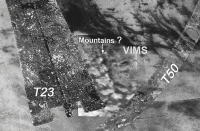
With the approach of T102 covering the area south of Yalaing Terra recent topographic maps of Titan from the 45th LPS conference (2014) came to mind for discussion. A very interesting abstract and figures was that of authors Z.Y.C Liu, J. Radebaugh, E.H Christiansen, C.D. Neish, R.L. Kirk, R.D. Lorenz and the Cassini Radar Team http://www.hou.usra.edu/meetings/lpsc2014/pdf/2766.pdf The abstract discusses the tectonic mechanisms of crustal uplift and mountain ridge locations on Titan emphasizing an east-west orientation of most ridges, concluding the most reasonable interpretation is that contractional tectonism built the ridges and thickened the icy lithosphere causing regional up-lift. Overlaying the mountain ridge map (Fig2 of the abstract) on existing ISS and VIMS maps of the region suggests a more north-south mountain ridge, higher than most of Titan’s confirmed mountains http://photojournal.jpl.nasa.gov/catalog/PIA09032 would be a remarkable observation indeed. The loss of T60 SAR coverage of this area is one major limit on the interpretation of the VIMS data in this region and is why there are no mountain ridges on the Liu et al map. VP has pointed out that some of the VIMS bright streaks have no mountain ridge correlation but the area is deserving of another attempt at SAR imaging I would think. Curiously, some T23 mountain ridges nearby are oriented more N-S than east-west! (mountain ridges are the dark structures in the image below).
|
|
|
|
|
|
|
Mar 24 2016, 04:21 AM
Post
#198
|
|
|
Member Group: Members Posts: 708 Joined: 1-April 08 From: Minnesota ! Member No.: 4081 |
A nice abstract http://www.hou.usra.edu/meetings/lpsc2016/pdf/2197.pdf
at the 47th LPSC conference on Titan discusses the 4 topographic rises in the southeastern quadrant of Titan. Spots A and D appear to be genuine elevated areas that have been examined by SAR imagery and SARTopo. Theoretical models suggest building these mountain plateaus “would require either a lower density material than the surrounding region (i.e., Pratt isostasy), or the mountain load was placed on top of the lithosphere.” Both mechanisms could result from cryovolcanic processes. Spot A (see SAR T53) is postulated to be of softer material easily eroded and has “badlands-style” erosion, whereas spot D (see SAR T07) may have a large channel emanating from a circular feature, possibly a caldera near the summit. Both spots A and D have been previously discussed in this forum after the publication of global topographic maps in Icarus by Lorenz et al in July 2013. (Maps kindly provided to UMSF by R Lorenz here: http://www.unmannedspaceflight.com/index.p...st&p=199847 (See below for some images of these areas). http://www.unmannedspaceflight.com/index.p...st&p=199824 |
|
|
|
|
Jan 31 2019, 11:21 AM
Post
#199
|
|
|
Senior Member Group: Members Posts: 3516 Joined: 4-November 05 From: North Wales Member No.: 542 |
Thanks to Phil for posting the link to the LPSC 2019 abstracts. There are many fascinating items in the Titan session including the intriguing possibility of two distinct liquid layers in the seas, molecular co-crystals and other organic chemistry. Here I will highlight in particular a paper on improved RADAR topography of Titan's mountains, hummocks and one dome/labyrinth.
http://www.hou.usra.edu/meetings/lpsc2019/pdf/2797.pdf |
|
|
|
|
May 2 2022, 05:17 PM
Post
#200
|
|
|
Member Group: Members Posts: 708 Joined: 1-April 08 From: Minnesota ! Member No.: 4081 |
A recent paper in Geophysical Research Letters https://agupubs.onlinelibrary.wiley.com/doi...29/2021GL097605 presents a hypothesis explaining the latitudinal variation of Titan's topography.
|
|
|
|
|
May 3 2022, 08:08 AM
Post
#201
|
|
|
Senior Member Group: Members Posts: 3516 Joined: 4-November 05 From: North Wales Member No.: 542 |
Interesting work, thanks for posting the link. All current modelling efforts are, however, hampered by a shortage of observational constraints, especially regarding the timescales of the various proposed landscape-forming processes both chemical and physical.
|
|
|
|
|

|
Lo-Fi Version | Time is now: 27th September 2024 - 10:10 AM |
|
RULES AND GUIDELINES Please read the Forum Rules and Guidelines before posting. IMAGE COPYRIGHT |
OPINIONS AND MODERATION Opinions expressed on UnmannedSpaceflight.com are those of the individual posters and do not necessarily reflect the opinions of UnmannedSpaceflight.com or The Planetary Society. The all-volunteer UnmannedSpaceflight.com moderation team is wholly independent of The Planetary Society. The Planetary Society has no influence over decisions made by the UnmannedSpaceflight.com moderators. |
SUPPORT THE FORUM Unmannedspaceflight.com is funded by the Planetary Society. Please consider supporting our work and many other projects by donating to the Society or becoming a member. |
|