Opportunity Route Map |

  |
Opportunity Route Map |
 Jun 26 2009, 09:42 PM Jun 26 2009, 09:42 PM
Post
#2536
|
|||
|
Senior Member  Group: Moderator Posts: 4279 Joined: 19-April 05 From: .br at .es Member No.: 253 |
You're welcome.
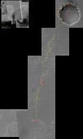
 For all you following the map in its GE version, I'll recommend downloading SFJCody's map extension posted here and covering the area south and west of the current position up to Endeavour, because now that the western path is the selected one, the route path will soon be out of the HiRISE picture featured in GE. Great job, SFJCody!
|
||
 |
 
|
||
|
Jun 27 2009, 05:00 AM
Post
#2537
|
|
 Member Group: Members Posts: 754 Joined: 9-February 07 Member No.: 1700 |
that's amazing! Flying around in the new Google was my latest ~wow!~ moment; this is another one. thanks Cody
|
|
|
|
|
Jun 27 2009, 05:40 AM
Post
#2538
|
|
 Senior Member Group: Members Posts: 2228 Joined: 1-December 04 From: Marble Falls, Texas, USA Member No.: 116 |
Thanks, Tesh, for reminding us to download the map extensions. I grabbed them tonight.
Thanks also, for your efforts, SFJCody.
-------------------- ...Tom
I'm not a Space Fan, I'm a Space Exploration Enthusiast. |
|
|
|
|
Jun 27 2009, 06:24 AM
Post
#2539
|
|
 Member Group: Members Posts: 813 Joined: 8-February 04 From: Arabia Terra Member No.: 12 |
That's only a temporary version! I'm hoping to do that at full resolution at some point (with help from James Canvin). New version will also have black set as the transparent colour so you don't see the frame at the edge of the image.
I have to replace a couple of broken sticks of RAM first, though. |
|
|
|
|
Jun 27 2009, 03:34 PM
Post
#2540
|
|
 Member Group: Members Posts: 399 Joined: 28-August 07 From: San Francisco Member No.: 3511 |
Thanks. I really appreciate your efforts to bring us more of Meridiani in google,
especially since my aging computer never got IAS viewer to behave, and the google folks aren't hinting at any updates... -------------------- 'She drove until the wheels fell off...'
|
|
|
|
|
Jul 11 2009, 09:04 PM
Post
#2541
|
|
|
Senior Member Group: Moderator Posts: 4279 Joined: 19-April 05 From: .br at .es Member No.: 253 |
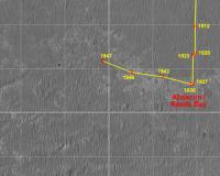
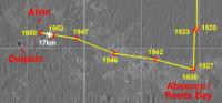
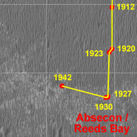
Here's a route map update after the drive on sol 1942.
  Route_Map_Sol1942.kml ( 23.82K )
Number of downloads: 420
Route_Map_Sol1942.kml ( 23.82K )
Number of downloads: 420 |
|
|
|
|
Jul 16 2009, 07:47 AM
Post
#2542
|
||
|
Senior Member Group: Moderator Posts: 4279 Joined: 19-April 05 From: .br at .es Member No.: 253 |
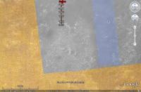
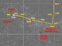
Now that Opportunity is heading west, it's time to update the whole picture in order to include new ground to the left, and since we are almost leaving the coverage of the HiRISE picture I was using on the map (PSP_009141_1780) it was the moment to add another one as background (ESP_011765_1780). The map is becoming really big --this version is 3000x5000 pixels and "weights" 1.3MB-- so I will probably post the whole picture not so often and only under certain circumstances like when adding another "square" to the map.
Here it is, updated up to sol 1946.
Route_Map_Sol1946.kml ( 24.01K )
Number of downloads: 439 |
|
|
|
|
|
|
Jul 17 2009, 07:57 AM
Post
#2543
|
|
|
Senior Member Group: Moderator Posts: 4279 Joined: 19-April 05 From: .br at .es Member No.: 253 |
|
|
|
|
|
Jul 20 2009, 06:37 AM
Post
#2544
|
|
|
Senior Member Group: Moderator Posts: 4279 Joined: 19-April 05 From: .br at .es Member No.: 253 |
|
|
|
|
|
Jul 22 2009, 01:53 PM
Post
#2545
|
||
|
Senior Member Group: Moderator Posts: 4279 Joined: 19-April 05 From: .br at .es Member No.: 253 |
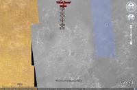
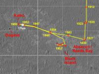
Here's a map crop, updated after sol 1952.
Route_Map_Sol1952n.kml ( 25.13K )
Number of downloads: 438Edit: Added "Block Island" to the KML file. |
|
|
|
|
|
|
Jul 24 2009, 08:25 AM
Post
#2546
|
||
|
Senior Member Group: Moderator Posts: 4279 Joined: 19-April 05 From: .br at .es Member No.: 253 |
Sol 1954; almost at the same site as on sol 1946.
Route_Map_Sol1954n.kml ( 25.35K )
Number of downloads: 417This post has been edited by Tesheiner: Jul 24 2009, 11:17 AM |
|
|
|
|
|
|
Jul 27 2009, 01:42 PM
Post
#2547
|
||
|
Senior Member Group: Moderator Posts: 4279 Joined: 19-April 05 From: .br at .es Member No.: 253 |
Sol 1957.
Route_Map_Sol1957.kml ( 25.6K )
Number of downloads: 439This post has been edited by Tesheiner: Jul 27 2009, 03:15 PM |
|
|
|
|
|
|
Jul 27 2009, 02:24 PM
Post
#2548
|
|
|
Junior Member Group: Members Posts: 90 Joined: 23-February 09 From: Edmonton, Alberta Member No.: 4611 |
Thx for the update... but my question...
is if we were nearing BI on Sol 1457 like on the map we should have been to Endeavour by now right  
|
|
|
|
|
Jul 27 2009, 03:17 PM
Post
#2549
|
|
|
Senior Member Group: Moderator Posts: 4279 Joined: 19-April 05 From: .br at .es Member No.: 253 |
Oooops! Thanks for the heads up... corrected now.
I think it's due to the summer vacations which are right at the corner. It may be affecting my skills.
|
|
|
|
|
Aug 3 2009, 03:42 PM
Post
#2550
|
||
 Senior Member Group: Members Posts: 1619 Joined: 12-February 06 From: Bergerac - FR Member No.: 678 |
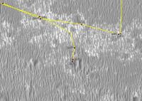
I took the liberty for updating the route map for the Sol 1963.
I think it's good, but it needs confirmations.
Attached thumbnail(s)
Attached File(s)
-------------------- |
|
|
|
|
|
|

|
Lo-Fi Version | Time is now: 24th April 2024 - 04:25 PM |
|
RULES AND GUIDELINES Please read the Forum Rules and Guidelines before posting. IMAGE COPYRIGHT |
OPINIONS AND MODERATION Opinions expressed on UnmannedSpaceflight.com are those of the individual posters and do not necessarily reflect the opinions of UnmannedSpaceflight.com or The Planetary Society. The all-volunteer UnmannedSpaceflight.com moderation team is wholly independent of The Planetary Society. The Planetary Society has no influence over decisions made by the UnmannedSpaceflight.com moderators. |
SUPPORT THE FORUM Unmannedspaceflight.com is funded by the Planetary Society. Please consider supporting our work and many other projects by donating to the Society or becoming a member. |
|