Printable Version of Topic
Click here to view this topic in its original format
Unmanned Spaceflight.com _ Spirit _ Home Plate Summary
Posted by: aldo12xu Feb 16 2006, 07:07 AM
Don't mean to compete against the Home Sweet Home thread, but I thought I'd put together a summary of the main observations and points discussed so far with regard to Home Plate, especially now that the thread is almost 20 pages long. I wouldn't be surprised that even after we eventually get the spectroscopy data, we'll probably still have a way to go before we get a handle on the origin of Home Plate.
So, anyways, I hope everybody finds the post of some use. The link is on my homepage.
Cheers,
Aldo.
Posted by: Nix Feb 16 2006, 08:14 AM
Very pleasing to read, as always, thanks Aldo!
Nico
Posted by: Bill Harris Feb 16 2006, 09:07 AM
Thanks, Aldo for that summary. Correct and concise, it is a welcome life-preserver for those of us becoming overwhelmed by these outcrops!
--Bill
Posted by: jamescanvin Feb 16 2006, 09:22 AM
Agreed, nice work Aldo. Nice to read somthing sensible about HP. I'm getting very confused with all the speculation.
James
Posted by: ljk4-1 Feb 16 2006, 02:27 PM
MARSDAILY
- Roving The Red Planet
http://www.spacedaily.com/reports/Roving_The_Red_Planet.html
Pasadena CA (JPL) Feb 15, 2006 - NASA's Mars rovers, Spirit and Opportunity,
have been working overtime to help scientists better understand ancient
environmental conditions on the red planet. The rovers are also generating
excitement about the exploration of Mars outlined in NASA's Vision for Space
Exploration.
- Home Plate Brings Mars Exploration To Every Desktop
http://www.spacedaily.com/reports/Home_Plate_Brings_Mars_Exploration_To_Every_Desktop.html
Posted by: aldo12xu Feb 16 2006, 03:57 PM
Glad everyone found the info useful. And thanks for the links, ljk. It's too bad the interview with Squyres was so brief. I think we're due for an update from him, maybe this weekend?
Posted by: SigurRosFan Feb 16 2006, 04:24 PM
Fantastic image!  Nice to see my virtual rover image.
Aldo, you use the old version. Try this:
http://xs68.xs.to/pics/06072/Sol_743_Pancam_Arriving_Home_Plate.jpg (614 KB)
Posted by: Zeke4ther Feb 16 2006, 04:42 PM
Truly outstanding! Sure keeps things clear for a non-geologist like myself. 
Posted by: aldo12xu Feb 16 2006, 04:51 PM
Oops, sorry about that, Nico. I'll fix it tonight after work.
Posted by: neb Feb 16 2006, 06:56 PM

So, anyways, I hope everybody finds the post of some use. The link is on my homepage.
Cheers,
Aldo.
Aldo: great image, A few observations I would like to note 1. The unit just above the lowest resistant bed appears to thin from right to left and may pinch out. 2. reddish mound on left side of image appears to be a basalt intrusion capped by thin HP sediments 3. beds draping over PM may indicate another basalt intrusion.
4. HP layers have been truncatedon on right side oof outcrop and extended an unknown distance in that direction which may indicate the current edge is near the center of an original saucer like accumulation.
5. Tim suggested groundwater,aqueous-mediated cementation of the upper beds which probably would't be possible unless the entire sediment pile were equally affected
Posted by: lyford Feb 16 2006, 08:03 PM
Thanks, Aldo, always a pleasure to see what you have in store!
Posted by: vikingmars Feb 18 2006, 12:44 PM
As a tribute and congratulations to Aldo for his FANTASTIC & nice website...
here is the full calibrated Home Plate mosaic from sol 743 delivered today to some friends at NASA...
PLUS its version as desktop wallpapers (1280x1024 and 1440x900 pixels).
Enjoy ! 
[quote name='aldo12xu' date='Feb 16 2006, 08:07 AM' post='41820'] ... and here are the 2 desktop wallpapers !
Enjoy !

|

|

|
Posted by: aldo12xu Feb 18 2006, 05:20 PM
Merci beaucoup, Olivier!! Great images, as always. Your renderings with the "Big Sky" and low sun always enhance the beauty of the Martian landscape.
Posted by: Nix Feb 18 2006, 05:52 PM
Very nice work Olivier. Agreed Aldo.
Nico
Posted by: RNeuhaus Feb 19 2006, 04:24 AM
Very nice romantic color pictures from Mars with Redish and dim light.
Rodolfo
Posted by: Pavel Feb 22 2006, 10:02 PM
Is there any information about composition of the HP? Why is everybody so obsessed with pretty pictures? Spirit has scientific instruments other than cameras, and I'm sure they were used on the HP rocks. My guess is the information is so sensational that it will be presented on a press-conference, just like finding past water by Opportunity was.
Posted by: Shaka Feb 22 2006, 11:20 PM
Hey, Pavel, welcome back, long time no see. Why do you think we're all - Well, some of us! are flaking out here? We drive up to the most amazing sight in Gusev Crater, Steve says, Nice layering! and then goes silent as The Sphinx. The PIs do the spectrometry at one or two spots, but never reveal a word about the results, Spirit then suddenly hauls

And then there's Exploratorium, but that's another rant...
Posted by: edstrick Feb 23 2006, 08:41 AM
Ok... contest: What's the silliest layered gunk we can come up with for lunatik-fringe specualtions on what Home Plate is made of?
How about Baklava?
http://www.yogurtland.com/images/baklava/baklava.jpg
Posted by: djellison Feb 23 2006, 08:47 AM
My guess is that they'll still trying to understand the MI images, the PC images, the TES data and the MB and APXS spectra to make the best interpretation of what they'll looking at. Things gont get answered by a single spectrum - they take context, understanding and interpretation.
Doug
Posted by: odave Feb 23 2006, 02:58 PM
...and add to that the time factor: Spirit needs to get to McCool Hill before winter sets in. To broaden the context, they'll need to see more of HP. To do that, they need to move from place to place fairly quickly. Adding my guess, they'll try to survey as much of HP as possible, then chew on the data over winter, and possibly return for more in spring, should Spirit still be alive.
Posted by: ElkGroveDan Feb 23 2006, 03:42 PM
How about Baklava?
http://www.yogurtland.com/images/baklava/baklava.jpg
How about Chinese Onion Cakes?
http://www.saturdaymarket.com/chinabreakfast/images/layered.jpg
Posted by: tdemko Feb 23 2006, 05:25 PM
Like just about everyone else, I'm waiting patiently for the interpretation of the analyses of the different Homeplate spectra. However, although I usually do not question the planning of the MER scientists and engineers (these people are heroes in every sense of the word), this long delay has made me dwell on the last few big moves, especially by Spirit.
Spirit made excellent progress from the crest of the Columbia Hills to Homeplate, and in fact, the approach to Homeplate seemed down right speedy (they seemed to have been hot on the trail!). Spirit drove directly up to an excellent cross section of the Homeplate strata and did a bang up job of collecting imagery and analyses (hopefully). Then, the bold charge up to the top of Homeplate. So far, so good...
I just finished Steve Squyres "Roving Mars" (wow, what a great book for rover geeks!), and he reiterated something that was said during some of the early MER briefings...that is, that the rovers can do in a sol what a human field geologist can do in a few seconds or minutes.
As a human field geologist, I've always then tried to keep the pace of the MER program into this context. So, here is where my experience would have led me to do the last few moves differently. The "Gibson" locality was pretty much pay dirt for Spirit. Although the Spirit team has kept a stiff upper lip throughout the exploration of Gusev, there has been a palpable disappointment that they did not find the lake they set out to find. This comes across very clearly in Squyres book. That is not to say that Spirit has not done huge science with the materials at hand. The analyses of the volcanic rocks, surficial sediments, and the altered volcanoclastic rocks of the Columbia Hills has been nothing less than fascinating. However, the elephant in the room is a little rover over on the Meridiani Plains literally sitting on a dried out sea bed, surrounded by slam dunk evidence for a large body of water.
Back to Homeplate...Spirit finds a significant section of layered, fairly unaltered, rocks. Bingo! Although my casual interpretations of the images have implied that they do not necessarily indicate the involvement of surface waters, I would not be suprised if there was some evidence somewhere in this section. If I were driving the rover, after the Gibson work, I would immediately have embarked on a circumnavigation of Homeplate to document this amazing stratigraphic section in detail. What are the lateral extents of the units? Are there facies changes? What is the depositional and structural dip of the strata? Are there even better, more complete sections of the strata that give us deeper views into older or younger parts of the stratigraphy?
I understand the need to get a view of the top of Homeplate...but, we could have easily guessed what we see now: the top of the cross-laminated upper unit, eroded and blasted by subsequent impacts. We get some nice views back to the Columbia Hills, and towards the Pitcher's Mound, but all indications are that times a' wastin' and they are already planning long drives into the surrounding hills for the winter. If it were me, I'd want as many analyses and images of the Homeplate strata as possible to chew on before bravely running away. Chances are that Spirit may not make it back...at all.
Posted by: Bill Harris Feb 23 2006, 08:01 PM
I think the same way. I was disappointed when they abandoned the Gibson site, I would have walked this outcrop southward toward Pitchers Mound and then made it to the top of Homeplate or started the climb up McCool Hill. The was a perfect chance to examine lateral changes in this section.
I'm really itching for Oppy to get moving and on that dark outcrop at Mogollon, I feel that it will be as important as the Gibson locale.
--Bill
Posted by: ljk4-1 Feb 23 2006, 08:11 PM
My question is, who is really running the show with MER: The geologists
or the engineers? Or management? The answer could explain the
current situation.
Posted by: djellison Feb 23 2006, 08:20 PM
Scientists say what they want
Engineers say what is possible
Management say what is fundable
More seriously -it's a case of the engineering team dictating what the scope for rover activities are, and the scientists choosing what to do within that scope.
It's a hard balance. But they've told us for months about the need to get to slopes. The option is to either sit here and try and do science while the rover dies...or...get something quick, get to the good slopes (with actually a quite reasonable chance of a healthy rover in 4 or 5 months ) and then revisit West Spur again.
It's not a choice they're really having to make - the calender and the dust are making it for them.
Doug
Posted by: RNeuhaus Feb 24 2006, 01:53 AM
Engineers say what is possible
Management say what is fundable
Everybody think when is possible to go home to care their family and friends. The funneral day would be a mix of feelings.
Rodolfo
Posted by: centsworth_II Feb 24 2006, 02:25 AM
I am not a geologist, but as interesting as a circumnavigation of Homeplate would be wouldn't it just provide different views of the same layers? Isn't making a transect of an interesting feature also a typical field technique?
Posted by: sattrackpro Feb 24 2006, 03:26 AM
The choice of "get it now, while we can" - or "get it later, after we escape a winter death" is a no-brainer... you act to stay alive, not die taking repeated one-last-looks.
Last winter, we did a lot of sitting in generally one place - but we did drive a bit, and get to new spots to marvel at. We found that drives raised the temperature inside the WEB, sometimes higher than expected - proving beneficial and getting to new places that still gave us the tilt toward the sun needed. I expect we'll see more drives this winter than last.
Posted by: dvandorn Feb 24 2006, 05:05 AM
Engineers say what is possible
Management say what is fundable
I'd put it slightly differently:
Scientists say what they want -- as long as it's published. If it's not yet published, they'll threaten you with reprisals if you even ask them what they think.
Engineers say what it possible -- but they often don't care if what is possible is actually do-able within the budget, or if it will actually work in a real-world situation. Or if it will work more than once.
Management says... whatever will make it most likely that, when the excrement hits the air circulation device, no one will be able to point to *them*. And whatever will make it most likely that any failure will result in someone else, and not them, getting fired over it.
-the other Doug
Posted by: Shaka Feb 24 2006, 05:05 AM
Nor am I, sir. (a geologist, I mean) And, yes, a circumnavigation could show exactly the same profile all the way around - but it might not - and under most circumstances, I suspect, that would be unlikely. We have seen two clear types of sediments (see Prof. Tim's lecture on the subject). We would desperately like to see more! We can see that there is not much more on top
 . There is still a chance that a third kind of deposit could appear at the bottom, somewhere around the edge of HP. This could be just another enigma, but it could also be definitive evidence of what HP is. The emanations from the PIs indicate that impact and volcanic origins are both in the running as to HP's origin. (The PIs already have spectroscopic info that could be definitive, but we don't know that. What they know might make the upper surface of HP much more important.) Another lower unit, however, will be that much closer to the source of the event; it might reveal impact breccia, or volcanic material that would settle the issue.
The recent flock of Mars geology papers show that different people can draw completely different conclusions from the same data! The PI's are going to want very conclusive evidence to support their future papers about Home Plate.
Posted by: dvandorn Feb 24 2006, 05:14 AM
Perhaps the hydrothermal or volcanic vent theories are still in the running for the origin of HP, and they really want to see if the center of the "vent" is any different, mineralogically or structurally, from the edges. That would tend to prove or disprove any vent theory. (In mroe geologic terms, radial observation/sampling of the feature is called for.)
So, see, there are circumstances in which it's not only OK to leave an interesting spot on a feature, it's a good idea to check and see if the data you've already collected is really pointing you in a given direction, or not...
-the other Doug
Posted by: edstrick Feb 24 2006, 08:31 AM
ElkGroveDan': How about Chinese Onion Cakes?
Um...they clearly have festoons. They're over at meridiani.
<grin!>
Posted by: Richard Trigaux Feb 24 2006, 01:09 PM
I am very puzzled too they don't publish any results of analysis. But if they do so, they may have a serious reason. I note that, anyway, on the rovers site, they often comment events and image extensively, but just quote analysis results in some words "basaltic rock" or the like. See the results of Ultreya analysis, keeping in three words, when this mistery was a leitmotiv since months.
Climbing on top of Homeplate, as tdemko noted earlier, seems useless:
But there may be a surprise with the analysis, or an unexpected difficulty. If Homeplate was simply some volcanic ash deposit, they would have found it easily and published immediatelly, as with Ultreya. If it was salt too. (after all, it is not the first salt we find on Mars). But their silence is tell tale of something else. either:
-the composition is completelly unexpected or very interesting (for instance limestone)
-the analysis were not conclusive, for instance Homeplate is a sandstone witht the grains and the cement of different compositions, as some microscopic imager images suggest. If so, the X ray spectrometer would show a mixture of the two spectra.
I cannot resist this guilty temptation...
-thick layers of mantras left by tibetan monks billions years ago.
Not bad enough?
-Billion years old beach with still footprints of beautiful martian maiden...
Still worse?
-Damn that stupids had to step just on my heap of unpaid bills.
Posted by: alan Feb 24 2006, 01:15 PM
Any explanation for the rock to the right of spirit's solar panels?
http://marsrovers.jpl.nasa.gov/gallery/all/2/p/749/2P192859966EFFAO55P2274L2M1.HTML
It almost looks like someone used a trowel to smooth part of it. 
Posted by: Bill Harris Feb 24 2006, 01:49 PM
Odd. Let's look a the L7 R1 images as a stereo pair.
I'll need to do this manually, so if someone wants to go ahead, feel free.
--Bill
Posted by: stevo Feb 24 2006, 03:06 PM
http://www.saturdaymarket.com/chinabreakfast/images/layered.jpg
I have to put in a vote for Kueh Lapis - fewer inclusions, more regular layering...
http://www.flickr.com/photos/46949250@N00/4395796/
Posted by: RNeuhaus Feb 24 2006, 03:56 PM
So, see, there are circumstances in which it's not only OK to leave an interesting spot on a feature, it's a good idea to check and see if the data you've already collected is really pointing you in a given direction, or not...
-the other Doug
I think it the same. I saw that the center of HP there is some kind of hole surronded by higher density of stones. It would be worth that Spirit stop over that and analyze the minerology structure there.
Rodolfo
Posted by: Holder of the Two Leashes Feb 24 2006, 05:46 PM
My guess is they're simply too busy right now, probably a bit of a crisis, trying to get home plate taken care of as best they can before they have to leave. We'll see the results soon enough when Spirit departs.
Millions of years of guano! We've discovered an ancient giant martian bat nesting site!
Posted by: ElkGroveDan Feb 24 2006, 05:59 PM
http://www.flickr.com/photos/46949250@N00/4395796/
I think I see a strike-slip fault there in the lower left.
Posted by: Richard Trigaux Feb 24 2006, 06:13 PM
I think that Homeplate is the most interesting site around, they should not depart so fast, and take the time to do what there is to do, without planning to come back one day (Spirit could stop working before). What is there to see in the hills that was not yet seen?
Eeeek! No wonder if they don't publish!
Hey but... What happens if the bats ARE COMING BACK???
Posted by: djellison Feb 24 2006, 06:18 PM
There's no choice to be made. The rover WILL DIE SOON if they stay here much longer. There's no question - it's a fact. They HAVE to go toward that good slope, and they HAVE to go SOON. When Spring comes, when the conditions are better, and there's every chance Spirit will survive winter, then they can revisit HP and do a proper job on it.
Doug
Posted by: Nix Feb 24 2006, 06:28 PM
I'd even say make the visit as short as possible so Spirit has all the more chance of being a healthy girl for a later, second visit.
Observations from Mc Cool Hill will add to the data collected now wether it's meaningful to return in the first place.(it probably is I recon)
On the way uphill we'll also get to see the isolated locations of exposed layering -which has been visible since the day Spirit landed btw and they look... I don't know but I hope to see 'em up close. For now I'm verry happy though to see Home Plate in this detail!
Nico
Posted by: ToSeek Feb 24 2006, 07:51 PM
Engineers say what is possible
Management say what is fundable
A scientist, an engineer, and a manager were driving in a car when the brakes fail just as they go over the top of a hill. The driver just barely manages to keep the car under control and then pull it to the side of the road and let it coast to a stop.
The manager says, "Okay, let's get together and develop a mission statement so we know how to handle this."
The engineer says, "No, it's no big deal, probably just a loose cable. I can fix it in five minutes."
The scientist says, "No, the first thing we need to do is to push the car back up the hill and see if it's reproducible."
Posted by: lyford Feb 24 2006, 08:35 PM
If it were a software engineer (s)he would have said:
"Turn it off, and everyone get out of the car then get back in and it should work fine..." 
Posted by: ljk4-1 Feb 24 2006, 08:42 PM
Three men are awaiting execution at the guillotine
during the French Revolution.
The first one puts his head in the stocks, but the blade
sticks in place and does not fall. The officials claim it is
an Act of God and let him go free.
Same thing happens to the second man.
Then an engineer puts his head in the stocks. He peers up
at the stuck blade and says:
"Oh, I see what's wrong with this thing...."
Posted by: Bob Shaw Feb 24 2006, 10:12 PM
"Turn it off, and everyone get out of the car then get back in and it should work fine..."
How many software engineers does it take to change a lightbulb?
None - it's a hardware issue.
How many Microsoft Certified Professionals does it take to change a lightbulb?
None - DarkNess ™ is the new industry standard
How many Systems Analysts does it take to change a lightbulb?
Do you really need that lighbulb?
Bob Shaw
Posted by: Holder of the Two Leashes Feb 24 2006, 11:17 PM
Now you know the REAL reason they're so anxious to get Spirit off of there!
Posted by: dvandorn Feb 25 2006, 03:38 AM
http://marsrovers.jpl.nasa.gov/gallery/all/2/p/749/2P192859966EFFAO55P2274L2M1.HTML
It almost looks like someone used a trowel to smooth part of it.
Looks more like someone troweled a thin layer of concrete over a rougher surface. In panel-like sections. One panel, for whatever reason, has resisted erosion, but adjacent panels have been flaked off, revealing the pebbly surface below.
Man -- this stuff does look a lot like concrete, doesn't it? A naturally-occurring concrete, of course... which is sort of what sandstone is, I suppose.
-the other Doug
Posted by: neb Feb 25 2006, 03:54 AM
Man -- this stuff does look a lot like concrete, doesn't it? A naturally-occurring concrete, of course... which is sort of what sandstone is, I suppose.
-the other Doug
That is a tough one, all I can say is it looks out of place and is not part of the bedded sequence. Also how how about the cylinderical feature imbedded in the top rock.
Posted by: Richard Trigaux Mar 3 2006, 11:34 AM
My hypothesis as what homeplate would be evaporites (Jarosite, Meridiani style) seems not to hold in front of close explorations.
My best guess now is for fall of volcanic cinder, away from a vent. Arguments:
-don't show erosion forms of the jarosite
-fine laminations crossing each other like in volcanic falls
-darker round grains into a finer white cement (could be cinder hail)
By the way such a formation perhaps needed more atmosphere than now (all the scoriaced lava blocks we see, where the holes are much larger than on Earth, are hinting for a thin atmosphere even in early Mars history). Perhaps the diametre of cinder hails could give an atmospheric density.
But the problem now is why they are not publishing the analysis results? Certainly not to "censor" them, but to reserve them for a thorough publishing of an unexpected or difficult result.
Basalt cinder would not be unexpected, there is basalt everywhere. So there is no reason that they delay the publishing of such a discovery. So my better guess is for an unusual lava, like the trachyte family or komatiites.
Komatiites, on Earth, result from the direct fusion of mantellic rocks, and they come at 1600°C in violent eruptions. They were common in ancient times, but very rare in more recent times. On Mars, we can expect they happened in early history, when the crust was still forming (assuming the mantle was liquid and very hot from accretion heat).
Trachytes, on Earth, result from a complete differentiation of lavas, the last step. Their magma chambers give rocks in the granite family. So they are elaborated continental rocks, hinting for the presence of cratons (continents building blocks, formed of granites) and of plate tectonics.
Discovering trachytes on Mars would be really a sensational event, an evidence the planet once had some plate tectonics like on earth.
Posted by: edstrick Mar 3 2006, 12:01 PM
Note that a lot of team members (and other planetary geosci-geeks) are prepping for presentation at the Lunar and Planetary Conference. This is one of the annual "biggies" for planetary geology researchers.
Posted by: paulanderson Mar 3 2006, 04:46 PM
My best guess now is for fall of volcanic cinder, away from a vent. Arguments:
-don't show erosion forms of the jarosite
-fine laminations crossing each other like in volcanic falls
-darker round grains into a finer white cement (could be cinder hail)
Yes, as noted in one or two of the othe HP threads, this is what the MER team is thinking now, that HP is the eroded remnants of a tuff cone or maar:
http://www.planetary.org/news/2006/0228_Mars_Exploration_Rovers_Update_Spirit.html
See this geology page also for illustrated earthly analogies (courtesy Kye Goodwin):
http://members.iinet.net.au/~boxer/WesternDistrict.htm
Even the volcanic bombs and cross bedding look quite similar to the HP images. What then about PM I wonder? Another tuff cone / maar? Scoria cone? If indeed an eroded volcanic cone, this also implies there was a groundwater table present, if we can go by an earthly analogy. Perhaps the "smaller concretions" seen and theorized about at HP are lapilli, as also mentioned on the geology page linked to?
I thought for a long time that HP and PM might be volcanically related, and wasn't convinced (and still not) that HP was simply a deposit left in an ordinary, eroded crater as some had suggested. I think either HP itself is a tuff cone / maar or a deposit left within a larger tuff cone / maar crater (there's some debate as to just what the MER team is referring to).
Posted by: CosmicRocker Mar 3 2006, 06:52 PM
Thanks especially for that last link, Paul. After looking at those examples and doing some related Googling, I think I can better understand what the Team may be thinking.
Posted by: Bob Shaw Mar 3 2006, 08:06 PM
http://www.planetary.org/news/2006/0228_Mars_Exploration_Rovers_Update_Spirit.html
See this geology page also for illustrated earthly analogies (courtesy Kye Goodwin):
http://members.iinet.net.au/~boxer/WesternDistrict.htm
Even the volcanic bombs and cross bedding look quite similar to the HP images. What then about PM I wonder? Another tuff cone / maar? Scoria cone? If indeed an eroded volcanic cone, this also implies there was a groundwater table present, if we can go by an earthly analogy. Perhaps the "smaller concretions" seen and theorized about at HP are lapilli, as also mentioned on the geology page linked to?
I thought for a long time that HP and PM might be volcanically related, and wasn't convinced (and still not) that HP was simply a deposit left in an ordinary, eroded crater as some had suggested. I think either HP itself is a tuff cone / maar or a deposit left within a larger tuff cone / maar crater (there's some debate as to just what the MER team is referring to).
Paul:
Regarding the Australian Maars etc, the bedding is, indeed *very* similar to that which we see at HP, right down to the smallest bedding details - but the *scale* of the structures is so different! I suppose that if we can identify more elements of a volcanic complex in the area then it'll be more credible. One other possibility, I think, might be localised pseudovulcanism as a result of an impact, with the effects of groundwater penetration allowing water alteration and enhancing the (temporary) violence of the events.
Bob Shaw
Posted by: Richard Trigaux Mar 3 2006, 09:59 PM
Regarding the Australian Maars etc, the bedding is, indeed *very* similar to that which we see at HP, right down to the smallest bedding details - but the *scale* of the structures is so different! I suppose that if we can identify more elements of a volcanic complex in the area then it'll be more credible. One other possibility, I think, might be localised pseudovulcanism as a result of an impact, with the effects of groundwater penetration allowing water alteration and enhancing the (temporary) violence of the events.
Bob Shaw
Bob, In Auvergne in France I have seen cinder laminations which closely look like Homeplate, scale and all. So there is no problem in the identification.
Posted by: RGClark Mar 3 2006, 10:13 PM
http://www.planetary.org/news/2006/0228_Mars_Exploration_Rovers_Update_Spirit.html
See this geology page also for illustrated earthly analogies (courtesy Kye Goodwin):
http://members.iinet.net.au/~boxer/WesternDistrict.htm
Even the volcanic bombs and cross bedding look quite similar to the HP images. What then about PM I wonder? Another tuff cone / maar? Scoria cone? If indeed an eroded volcanic cone, this also implies there was a groundwater table present, if we can go by an earthly analogy. Perhaps the "smaller concretions" seen and theorized about at HP are lapilli, as also mentioned on the geology page linked to?
I thought for a long time that HP and PM might be volcanically related, and wasn't convinced (and still not) that HP was simply a deposit left in an ordinary, eroded crater as some had suggested. I think either HP itself is a tuff cone / maar or a deposit left within a larger tuff cone / maar crater (there's some debate as to just what the MER team is referring to).
Thanks for the links. What might be key is the "bomb sag" features given on the volcanic features in Western District of Victoria page:
Volcanic bomb sag in tuffs at the Lake Purdiguluc maar.

Volcanic bomb sags in tuffs at the Tower Hill maar complex.

On the http://www.geology.sdsu.edu/how_volcanoes_work/Hydrovolcanic.html page is also given an example of a bomb sag:
Bomb sag.

There was a discussion on Uplink.space.com about some Spirit images that might show a bomb sag, referred to as a "drop stone" on that forum:
Uncalibrated color image at Home Plate.

Taken from these Pancam images:
Panoramic Camera :: Sol 751.
http://marsrovers.jpl.nasa.gov/gallery/all/spirit_p751.html
Bob Clark
Posted by: Richard Trigaux Mar 3 2006, 10:20 PM
That Homeplate would be volcanic is very likely.
But my point was rather on the COMPOSITION: if it was just another variety of basalt, they would have published it immediately, as they did for all the other rocks. The fact that they did not (yet) published the analysis results hints that they found something SPECIAL about this composition: unusual, unexpected, or unexplainable. So among possible candidates, volcanic or not volcanic:
-trachytic cinders (Usually such cinder are trachytic, but we also find some basaltic cinders)
-komatiites
-carbonatite (can form thin cinders which harden like concrete)
-limestone. In this case, there is a strong evidence of an ocean, not just a temporary one, but a long standing ocean, hot enough for limestone formation (not under an ice cap).
-limestone cementing round grains which could be fossils. If this is the case, I understand that they want some more checking before publishing!
-other
Please note also that maars form when there is a lava emerging through a watertable or water stream. But they don't do cinders, rather special kind of irregular bombs.
But komatiites, which erupt very violently, can also form maar-like holes.
Posted by: paulanderson Mar 3 2006, 10:23 PM
Good point about the scaling. In a previous post in "Home, Sweet Home," sattrackpro had pointed out that HP seems to be surrounded in its immediate environs by the "frothy boulders" which, as he mentioned, seemed to imply a possible direct volcanic connection to HP and maybe PM as well. I'm just keeping in mind also that the MER team has the initial analysis results in hand, which we (or most of here anyway?) haven't been privy to yet. The impact idea is possible of course, I'm just not sure we always need to associate impacts with almost everything we see on Mars (I just think there is sometimes a general over-tendency to do that, since we've learned that Mars is much more geologically diverse than used to be thought in the 60s - 80s for example). But as mentioned elsewhere, this will all sort itself out I'm sure.

Posted by: vikingmars Mar 4 2006, 03:50 PM
Well...
(i) to please all the Forum contributors ;
(ii) to thank its Administrators for all the work they are doing for us in keeping alive this wonderful tool of exchange ;
(iii) to honour the 2 discoverers of the Home Plate feature (Dr. Nathalie Cabrol and Dr. Edmond Grin at NASA/AMES + their student in Paris Gilles Dawidowicz who helped them map the Gusev crater and identify features inside),
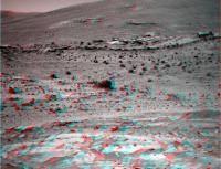
here is the sol 758 fully calibrated mosaic (reduced 50% in size to fit in the Forum)
PLUS the same image as desktop wallpaper for you to enjoy ! 1st desktop wallpaper
(2nd desktop wallpaper)

|

|

|
Posted by: Bob Shaw Mar 4 2006, 05:30 PM
Well... (i) to please all the Forum contributors ;
(ii) to thank its Administrators for all the work they are doing for us in keeping alive this wonderful tool of exchange ;
(iii) to honour the 2 discoverers of the Home Plate feature (Dr. Nathalie Cabrol and Dr. Edmond Grin at NASA/AMES + their student in Paris Gilles Dawidowicz who helped them map the Gusev crater and identify features inside),
here is the sol 758 fully calibrated mosaic (reduced 50% in size to fit in the Forum)
PLUS the same image as desktop wallpaper for you to enjoy !
1st desktop wallpaper(2nd desktop wallpaper)
I think I got a new desktop! Thanks!
Bob Shaw
Posted by: Phil Stooke Mar 4 2006, 06:11 PM
The bomb sag images look very convincing... but presumably impact ejecta blocks falling into soft layered sediments - say groudwater-soaked aeolian bedded drifts - would look the same. The mere appearance isn't enough to prove a volcanic origin. We have to get the chemistry.
Phil
Posted by: Zeke4ther Mar 4 2006, 06:39 PM
Well... (i) to please all the Forum contributors ;
(ii) to thank its Administrators for all the work they are doing for us in keeping alive this wonderful tool of exchange ;
(iii) to honour the 2 discoverers of the Home Plate feature (Dr. Nathalie Cabrol and Dr. Edmond Grin at NASA/AMES + their student in Paris Gilles Dawidowicz who helped them map the Gusev crater and identify features inside),
here is the sol 758 fully calibrated mosaic (reduced 50% in size to fit in the Forum)
PLUS the same image as desktop wallpaper for you to enjoy !
1st desktop wallpaper(2nd desktop wallpaper)
Excellent work! Thanks for the desktops.
Posted by: aldo12xu Mar 6 2006, 04:33 PM
Works of beauty, Olivier!!
....and yes, it looks like the case for a maar or tuff cone is getting stronger.
And getting back to what Richard Trigaux said in Post #50, what's interesting is that in Squyre's Journal of Geophysical Research 2006 paper, he describes the Backstay class of rocks as basalt/trachybasalts and that Peace is comprised of ultramafic sand grains (komatiites??). Another paper mentioned that Clovis has basaltic glass as it's principal component.
Posted by: Bill Harris Mar 7 2006, 01:52 AM
And getting back to what Richard Trigaux said in Post #50, what's interesting is that in Squyre's Journal of Geophysical Research 2006 paper, he describes the Backstay class of rocks as basalt/trachybasalts and that Peace is comprised of ultramafic sand grains (komatiites??). Another paper mentioned that Clovis has basaltic glass as it's principal component.
Yes, crumbs have been dropped for us for some time now. Many of these little puzzle pieces are going to start coming together.
Here is something interesting from today's imagery: we have the contact of the lower part of the Homeplate formation with the underlying unit, and the unit below that is the "fractal spongebob" scoria. Looking at other images, we can see weathered outcrops of bedded after bedded unit.
This is going to be a productive Winter.
--Bill

Posted by: neb Mar 7 2006, 04:48 AM
Bill: I have reviewed the images you refer to but my view differs somewhat.
I see steepening of the dip from the flat HP beds we have been on to fairly high dips at the edge of the outcrop in the foreground.including some of the basal HP unit. Mar 06 image 02075
I do not see any vescicular basalt in place which would represent a lower stratigraphic unit.
I did see several bomb -erratics in the x-bedded sediments which suggests ejected volcanic beds and a more convincing feature is the drape of HP eqivalent units over a small rise along the ridge immediately in front of us. This drape almost has to be associated with air-fall material.
I do agree that we are going to see more of these HP type beds at different elevations because they covered the topography at the time and have now been seperated by erosion into isolated patches.
Posted by: Richard Trigaux Mar 7 2006, 07:56 AM
I somewhat agree and somewhat disagree with neb.
The scoriaced basaltic blocks we see could have been added here much afterwards by meteorites impacts, as much of the blocks we see everywhere. So it is difficult to conclude.
"my" paradigm about Homeplate and the overal surrounding hills, that I already explained in this discution, is that the hills would be large spans of ancient soil, expelled by the Gussev impact, and which fell back in place (eventually upside-down) and were broken, folded, crunched, while keeping a recognizable layer pattern. Such formation can be seen in the Ries crater, in Germany (Sorry for Bruce Moomaw, but the exploration of Ries crater was made by manned missions, not robotic ). It is a bit surprising, but the evidences are just under our feets.
So the hills would be remnants of very ancient terrains, dating back perhaps to the formation of the martian crust, no less.
We earthlings are accustomed to see ancient terrains heavily metamorphised or eroded. On Mars this don't seems to happen, and we look at four billions years old lava scorias which look as fresh as what we can pick on a recent Earth volcano, I even have some at home that I gathered in the chaîne des puys, France.
But martian holes are larger, hinting for a weaker atmosphere from the very beginning of Mars history.
Also in the image above, the leftermost big bomb looks a bit like if it was formed in a phreatomagmatic eruption. A close look would be interesting, as knowing for phreatomagmatic eruptions on Mars would be an evidence for past water.
Posted by: abalone Mar 7 2006, 10:04 AM
Could it be that these layers in the distance and on the side of McCool hill are a continuation of the Home Plate sequence? I know its not new speculation but the evidence appears to be mounting
|
Posted by: neb Mar 7 2006, 05:17 PM
Abalone: I am confident the beds you refer to are equivalent to the HP section but possibly reduced in thickness. It will be interesting to see what their dip is.
Posted by: Shaka Mar 7 2006, 07:06 PM
Hmmm...well now. Do I get the drift from this discussion that HP may not represent a specific impact or volcanic structure, but perhaps just a chance residue of once continuous beds filling inner basin?

Posted by: Bob Shaw Mar 7 2006, 07:37 PM
Yup!
Though perhaps not all-enveloping - though any airfall could well be such.
Bob Shaw
Posted by: paulanderson Mar 7 2006, 07:58 PM
Though perhaps not all-enveloping - though any airfall could well be such.
Bob Shaw
But the MER team seems to be suggesting, almost with certainty now, that HP is a remnant maar / tuff cone. Airfall deposits would then be expected to be found, would they not? Couldn't the other nearby possible deposits be remains of other similar vents? Like others noted before, why is the ground around and near HP seemingly littered with the "sponge rocks"? Plus the imbedded (apparent) volcanic bombs in HP itself. All these things need to be taken into account. But again, I want to wait until they say more officially.
Posted by: Shaka Mar 7 2006, 08:30 PM
Though perhaps not all-enveloping - though any airfall could well be such.
Bob Shaw
 Donnerwetter nochmal! I suppose this finding was always lurking off in the fringes of our imaginations, like a gray stormcloud threatening our bright postulates for Home Plate. And I suppose we needn't hope to rove into the extinct volcano that did all this, since it could be far away or deep beneath the plains lavas. Sad, if true, but at least it will salve our regret if Spirit never returns to the Ballpark.
 Side note: I got very confused by the latest batch of MIs at Exploratorium: http://qt.exploratorium.edu/mars/spirit/micro_imager/2006-03-07/
until I figured out that they were over six months old! How can relics of the past like this suddenly show up? Surely these were not languishing in the deep recesses of Spirit's memory all this time! (I am unavoidably reminded of a Woody Allen seasickness joke about "a lunch he had in 1956".) sorry
Posted by: imipak Mar 7 2006, 08:33 PM
Surely HP-liked layers on McCool and/or Michaeltree Ridge doesn't disprove the volcanic vent theory. (I may not know much* geology but I seem to recall that there are large areas of Siberia and the Indian subcontinent covered by lava flows from one location, albeit a very large one with a completely different aetiology
Another factor -- presumably gravity 33% of that on earth would tend to mean that volcanic ejecta would tend to go higher and further from the source. And some have mentioned the possibility that the vent was actually submerged in a shallow sea or lake (rather than just occuring through water-soaked sediments) -- in which case explosive ash and other sediment would presumably be distributed by any currents or even just convection from the heat of the vent.
* s/much/any/
Posted by: odave Mar 7 2006, 08:36 PM
It all depends on the image priority. Images that deal with the next sol's drive/sequence planning always have higher priority than other data products. Some of them may in fact be parked in flash for a long time, simply because other images need to get down first, and there isn't enough time in the pass to get to lower priority items. Check out the http://www.unmannedspaceflight.com/index.php?s=&showtopic=2162&view=findpost&p=40358 from the 1/31/06 pancam update, 3rd DE question
Posted by: tty Mar 7 2006, 08:54 PM
Another factor -- presumably gravity 33% of that on earth would tend to mean that volcanic ejecta would tend to go higher and further from the source. And some have mentioned the possibility that the vent was actually submerged in a shallow sea or lake (rather than just occuring through water-soaked sediments) -- in which case explosive ash and other sediment would presumably be distributed by any currents or even just convection from the heat of the vent.
* s/much/any/
The deposits You are thinking of (the Siberian and Deccan traps) are plateau basalts which is a completely different type of deposit (and eruption).
If the eruption actually occurred underwater there should be pillow lavas around somewhere.
tty
Posted by: Bob Shaw Mar 7 2006, 08:56 PM
Another factor -- presumably gravity 33% of that on earth would tend to mean that volcanic ejecta would tend to go higher and further from the source. And some have mentioned the possibility that the vent was actually submerged in a shallow sea or lake (rather than just occuring through water-soaked sediments) -- in which case explosive ash and other sediment would presumably be distributed by any currents or even just convection from the heat of the vent.
* s/much/any/
The problem with a discrete volcanic vent is that we *want* it to be there, so modify our interpretations to fit rather than basing our interpretations on the more prosaic features which we actually *see*. It's human nature to want HP to be a bit more 'special' than it is - but if it helps establish a common stratigraphy over a much wider area, by simply being the most closely-examined example of a whole formation, then really it's *more* valuable than a dramatic little fumarole with no context.
Onward!
Though I'd still like to circumnavigate HP!
Bob Shaw
Posted by: Zeke4ther Mar 7 2006, 09:01 PM
http://qt.exploratorium.edu/mars/spirit/micro_imager/2006-03-07/
until I figured out that they were over six months old! How can relics of the past like this suddenly show up? Surely these were not languishing in the deep recesses of Spirit's memory all this time! (I am unavoidably reminded of a Woody Allen seasickness joke about "a lunch he had in 1956".)
These are low priority items that JPL has finally been able to download. There is a good explanation in the Pancam update intervew that Doug had with Jim Bell
http://www.planetary.org/explore/topics/mars_exploration_rovers/audio.html
(I think it's this one, or the interview prior
)edit: Looks like odave beat me to it! And he has the exact answer.
Posted by: paulanderson Mar 7 2006, 09:10 PM
How do we know HP isn't 'special' (in the sense of being a volcanic vent or something similar)? As I noted a couple posts ago, the MER team is thinking differently about this (so far anyway) and they are the ones with all of the analysis results in hand, which we haven't seen yet, plus all of the volcanic features in and around HP have to be considered. I just think it's too early to make absolute declarations either way, that's all. I wish Steve would do another update soon...
Posted by: Shaka Mar 7 2006, 09:16 PM
O.K., ODave, I'll concede it's possible. I'm just very surprised that the MERs have so much memory to burn that we can neglect to download so many MIs for so long. How can MIs be so low in priority? How can there be no download opportunities over 6+ months? It's almost like somebody (or some computer) forgot they were there, yet I can't conceive how that could happen. How many other views might still be lingering up there?
You can tell I'm no engineer, can't you.
Posted by: Richard Trigaux Mar 7 2006, 09:23 PM
tty
Not necessarily. Pillow lavas occur when there was a fluid lava flow under the sea, usually basalt.
Underwater explosions rather form special bombs in "chou fleur" we say in french, I don't know in english.
That Homeplate could be a cinder layered deposid don't necessary implies that the vent would be in the center of Homeplate. Such deposits on Earth can occur very far from the vent, cover a steep volcano flank, or extend in far plains ten or thirty kilometres away. If we add to this that Husbands hills were disturbed, broken and eventually turned upside down plates of pre-Gussev terrain, out chance of ever finding the vent are very weak. But for a volcanologist, stratigraphy and composition of an ashfall tell much more than the shape of the vent.
STILL NO ANALYSIS RESULTS????
Posted by: Shaka Mar 7 2006, 09:26 PM
What if we all went outside and looked at a star and crossed our fingers and said, "I wish, I wish, I wish!"
Posted by: Bill Harris Mar 7 2006, 09:26 PM
My first thoughts on this are that the HP formation represents an airfall deposit of volcanic ash but, as noted, the MER team is leaning toward a maar/tuff cone feature. I'm not at all lemming-like, but I'm inclined to lean in that direction, too, since they are playing with a better hand than I.
I'll give a definite maybe to both interpretations until I know better...
--Bill
Posted by: djellison Mar 7 2006, 09:29 PM
You can tell I'm no engineer, can't you.
It's not a case of memory to burn, it's simply what's important. These images are not important. They were the extreme ends of a focus-pull for the MI etc. Spirit's been very busy in the last few months, and so has had lots of high priority imagery ( for driving, new panoramas etc ).
How many other images are up there? According to the pancam tracking page,
There are 3633 individual imaging products onboard totallying 700.3 Mbits on Spirit, 3946 products totalling 923 Mbits on Opportunity. Some of these will simply be images that have been downloaded but not deleted, some of them will be one's that have not been deleted. Huge numbers (the vast majority) of them are likely to be tiny reference files, downsampled autonav imagery etc - things that hardly even count as images.
Doug
Posted by: Phil Stooke Mar 7 2006, 09:37 PM
chou fleur - cauliflower (he said cryptically)
Phil
Posted by: Shaka Mar 7 2006, 09:54 PM
How many other images are up there? According to the pancam tracking page,
There are 3633 individual imaging products onboard totallying 700.3 Mbits on Spirit, 3946 products totalling 923 Mbits on Opportunity. Some of these will simply be images that have been downloaded but not deleted, some of them will be one's that have not been deleted. Huge numbers (the vast majority) of them are likely to be tiny reference files, downsampled autonav imagery etc - things that hardly even count as images.
Doug
Thanx, Doug. As usual you're the man with the answers. I even learned a new MER function - a focus-pull - I didn't know about. I suppose the amounts of memory tied up in those thousands of imaging products are a trivial percentage of the total available, which is rarely if ever strained by MER operations, otherwise the controllers would delete them. It's reassuring to know that things are even better in hand than I'd hoped. I do worry too much.
Posted by: Richard Trigaux Mar 7 2006, 10:07 PM
Phil
Thanks. I don't know if english speaking geologists call this a cauliflower bomb, but everybody will catch the image and see how these bombs will look like.
These bombs form when a quantity of lava is quickly mixed with water, a thing which of course results in a large explosion. This happens in submarine strombolian activity, but also in maars, when the lava climbs through a watertable, or when a stream pours into the maar. It is these explosions which form the maar and project debris and ashes far away, so that maars often have no rims.
NEW UPDATE ON THE NASA SITE AND STILL NO ANALYSIS RESULTS.
Posted by: neb Mar 7 2006, 10:56 PM
Shaka: In a way the HP deposits are related to an impact structure in that they accumulated in a depression caused by an earlier impact and were preserved by the protection this low area provided.\While on speculations, are the scattered chunks of viscicular basalt associated with a thin flow at a later time or are they air -fall erratics associated with a volcanic eruption. Mainly because of their distribution, I am inclined to think they are ejecta but would it not require a different vent source from the HP volcanics because of a their mafic composition??
Posted by: Shaka Mar 7 2006, 11:51 PM
Back when I was rude and crude I might have made a joke about this, but no more!
Tell me, Richard (is my pronunciation - Reeshard - correct?) can you tell me something about the pioneer, Faget. His name has been given to one of the rocky exposures on McCool Hill. I know Korolev but not Faget (Fajay? I hope) TIA
Neb, (do you spell your name backwards in the yellow forum?), I'm pleased to see that you are keeping the faith on our impact postulate. You would agree that if we could core down far enough we would find suevite, breccia, shatter cones, PDFs - the whole box-and-dice?. (It might be hard to find a place on Mars where you wouldn't, right?) If these spongebob rocks went flying up into the air, would they come down looking this good, and in a non-random distribution? Why is it that, try as I might, I just can't see the vesicular, vacuolar, styrofoam structure of the laminated cross-bedded upper unit of HP?? I look at it, and all I see is sandstone! http://marsrovers.jpl.nasa.gov/gallery/all/2/m/753/2M193210336EFFAOA0P2956M2M1.JPG
I see lots of little bumps, and under each bump is a partly-rounded, dark grain of "olivine-rich basalt", bound up with a lighter matrix that, apparently, is not sulfate. Why don't I see more openings, exposed on the surface, to all these vacuoles? Some of us used to think that this unit was like Eldorado well steeped in brine and then dried. Why am I the only one left who thinks that?
Your guidance is appreciated, and, if Tim Denko is reading, yours also.
Posted by: tdemko Mar 8 2006, 12:08 AM
Although everyone seems to be jumping on the all-volcano, all-the-time bandwagon, seemingly based on the whiffs of interpretation we get from the Cornell/JPL/etc. folks, I'd like to speculate on some alternatives.
The Homeplate section is made up of three basic packages of material: (1) the lower interbedded series of coarser-grained, fining-upward (graded) units; (2) medial units consisting of crudely bedded to massive, clotty-looking material, sharply bounded above by (3) lighter-colored, fine-grained, moderately well- to well-sorted cross-laminated strata. The strata in unit (1) are discontinuous, thicken and thin across the outcrop, and show onlapping relationships with underlying strata. The strata in units (1) and (2) show very steep dips on the side of Homeplate where Spirit currently is working. Dips in unit (3) vary across the examined outcrop, but seems to be overall much less than the underlying units.
Are the dips that we see structural (due to deformation by some sort of tectonism) or are they depositional (due to filling in of irregular buried topography)? The underlying pre-Homeplate strata seem to have widely varying dips, but not totally chaotic....there seem to be some broad antiform-synform structures that are traceable in the general Homeplate-Pitcher's Mound-Columbia Hills lowlands area. However, it seems to me that Homplate units (1) and (2) are locally much more steeply dipping, and in Spirit's partially completed circumnavigation, it seems that they are dipping radially towards the center of Homeplate.
This still looks like the margins of a crater fill to me. The fining-upward nature of the interbedded units indicates to me that these are some sort of repeated sediment gravity flows. Could they have been sourced by nearby volcanic vents? Sure, no reason why not. Could the crater be volcanic instead of impact-generated? Again, no reason why not. However, both units (1) and (2) look like they have undergone some alteration, cementation, or welding. Unit (2) is a real mystery to me as far as a depositional or volcanic origin. Some of it looks even mudflow/lahar-like to me. The very sharp upper boundary is particulary intriguing.
Unit (3) is likely a depositional unit. It seems to me to be too well sorted and cross laminated to be a primary ash fall. The pictures of terrestrial base surge deposits posted recently are all very evocative as far as some of the structures. However, they all have much different sorting and lots of variation in clast composition. Plinian eruptions and other explosive volcanic events are violent messy deals that involve primary ash and cinders from the cooling and crystallization of recently molten material, and lots of chunks of previously erupted solid material from around the vents and in the (say this like Dr. Evil) magma plumbing system. That's why we see the variation in clast size, composition, and those cool bombs and bomb sags in the earth photos. Unit (3) may have started out as a primary ash fall locally, but it must have been subsequently significantly reworked (sorted and stratified) by aeolian processes. Remember, our one good "dropstone/bomb-sag" from the images is in unit (1). Unit (3) is uniform through the examined areas of Homeplate as far as texture, and presumably composition. The spherical grains also suggest a period of reworking and rounding. There did not seem to be any angular clasts or pieces of breccia present at all in unit (3) in the images we've seen so far.
Homeplate seems to fit into somewhere into the classification of "volcanoclastic" rocks. That is, that the primary material that makes up the units did once erupt out of volcanic vents. There have been other volcanoclastic units described during the traverse up and down from Husband Hill. However, the Homeplate strata are distinctly different in that they seem to have undergone significant sedimentary transport and reworking. The presumably older volcanoclastic units were all poorly sorted conglomerates and breccias. Homeplate is different, and important, because of the various expressions of distinct sedimentary fabric and textural maturity that we observe. The views across the basin and towards McCool Hill suggest that there are more outcrops of these types of units. They may be correlative units, or they may be similar deposits higher or lower in the stratigraphic succession.
Maybe it's because of my local geology here along the north shore of Lake Superior in Minnesota, but I am not all that suprised by this mixture of volcanic, volcanoclastic, and sedimentary units. Just a mile or so away from me are wonderful outcrops of extensive, thick, stacked, lava flows, ash flows, related layered mafic plutons, and beautiful successions of interbedded sedimentary deposits with exquisite crossbeds and cross-lamination, all 1.2 billion years old. And as red as Mars...
Posted by: Shaka Mar 8 2006, 12:40 AM
Lecture 4 - Right on the money.
Posted by: monty python Mar 8 2006, 03:15 AM
Posted by: Phil Stooke Mar 8 2006, 03:35 AM
Maxime Faget, designer of much of the early US manned space hadware...
Wich feature is Faget? (edit - now I know, here's a new map at JPL)
Phil
Posted by: Shaka Mar 8 2006, 04:00 AM
Wich feature is Faget? (edit - now I know, here's a new map at JPL)
Phil
Right, and here's an informative 'unofficial' lateral view: http://img419.imageshack.us/img419/7/innerbasin99rvonbraunetc5jv.jpg
I'm guessing we might get a good look at Korolev and Faget, the others...??
What sort of stuff did Faget design?
What did Oberth do?
Posted by: dvandorn Mar 8 2006, 04:41 AM
What sort of stuff did Max Faget design? Lessee -- the Mercury, Gemini and Apollo spacecraft, for a few... he also did a lot of design work for the Shuttle, though his main design ultimately was not used (the first time an American manned spacecraft did not come more or less directly from Faget and his nuts-and-bolts design engineer, Caldwell Johnson, who fleshed Faget's concepts out into detailed mechanical drawings).
-the other Doug
Posted by: CosmicRocker Mar 8 2006, 04:43 AM
Actually Shaka, the concept that the discontinuous cap-like layers on the various mesas and other landforms in this basin might be the eroded remnants of once more-continuous layers that covered the area has been one of the running hypotheses in this forum for quite a long time now. What is not yet clear is that all of the layers that appear to drape this area are the same as those at Home Plate. It seems a good bet that they are stratigraphically related, but we haven't seen enough of these layers closely to be confident of that. It wasn't that long ago that the cap-like layer on Pitcher's Mound was speculated to be the same as Home Plate, but now that we have seen it more closely, that seems unlikely.
Tim: Thanks for the excellent discussion of the observations so far. Regarding the lower unit #1, and possibly also #2, I see similarities to turbidites. I can easily picture such things forming in a water-filled crater. Later, it dries up, undergoes erosion, and then a sharp contact can be formed when eolian sediments are laid on top. We just haven't seen enough of that contact to know what it's geometry is. Another more basic problem I am having is due to the fact that I don't have a lot of real experience with volcanic deposits, so I tend to see sedimentary analogs when I see layering. So, I am still trying to be open-minded about the volcanic/basal surge thing for the lower units, but unit #3 surely must be sourced from elsewhere, or reworked local stuff.
Posted by: Shaka Mar 8 2006, 07:16 AM
-the other Doug
Awesome. And I didn't even know his name.
(How did Max pronounce it? I want to get it right. I owe him that.)
Posted by: Shaka Mar 8 2006, 07:48 AM
C'mon, Tom, don't just light up the room and then leave. What about HP vs PM (or should I say von Braun?) I'm here to learn. Why isn't it likely anymore?
Only Salvador Dali could be comfortable with the Pitcher's cap, but what does geology tell us?P.S. I'm going to grab a few hours of shuteye, Doug. You might as well hit the sack too.
Posted by: Richard Trigaux Mar 8 2006, 08:08 AM
Tell me, Richard (is my pronunciation - Reeshard - correct?) can you tell me something about the pioneer, Faget. His name has been given to one of the rocky exposures on McCool Hill. I know Korolev but not Faget (Fajay? I hope) TIA
Sorry I did not caught the joke about cauliflower bombs, perhaps it is better not to tell
Yes reeshard is the correct pronunciation, but in french we don't swallow our tongue to say "r".
About Faget, sorry I don't know. Try googling, but faget is a common family name and place name. I found this on Wiki: http://fr.wikipedia.org/wiki/Paul_de_Faget_de_Casteljau. I appreciate the sporadic team efforts to give names which are from other cultures than english/US, after all "they come in peace for all mankind". A little wheel turn for a robot, but a great turn for mankind...
Posted by: general Mar 8 2006, 08:51 AM
http://www.kiosek.com/oberth/
Posted by: Bill Harris Mar 8 2006, 09:08 AM
Very good comments, Tim. I am still not lemming-like, but I am rocking on the maar---aeolian volcanoclastic fence because, like CosmicRocker, I am not well-versed in volcanics. Although on faith I'll lean towards the cataclysmic eruptive event, my instinct suggests to me that we are looking at the uniformitarian series of volcanics and aeolian processes.
I'm glad to see that the features on McCool Hill are named and named after space and rocket pioneers. Especially Goddard and VonBraun since this tells me that these features will be visited.
I wish thay we had lithologies on these rocks, but in the publish-or-perish world of research I can undserstand; it is still wonderful getting to see the imagery and be able to participate in this adventure.
--Bill
Posted by: dvandorn Mar 8 2006, 01:09 PM
Max Faget was from Louisiana -- the name was French in origin. It was pronounced Fa-zhay.
-the other Doug
Posted by: djellison Mar 8 2006, 01:17 PM
I've always pronounced it like Faberge, but with out the 'ber' in the middle
Doug
Posted by: Shaka Mar 8 2006, 06:54 PM
Thanks, Danke, Merci, Gentlemen.
Yes, Oberth, Goddard and von Braun may wait for a return trip.
Posted by: imipak Mar 8 2006, 08:07 PM
neb, your use of the word 'distribution' there reminded me that on the lower slopes of McCool behind Mitcheltree Ridge, there seem to be distinct demarcation lines between regions liberally scattered with free-standing rocks on the surface, adjoining areas with very few. Abalone's anaglyph shows it up really well:
http://www.unmannedspaceflight.com/index.php?act=Attach&type=post&id=4410
I don't think it's just a trick of perspective, though I've been wrong before
So - question: are there any maps showing the distribution of individual free-standing surface rocks along Spirit's track? I imagine this would be well beyond the scope of non-professional efforts, purely because of the time it would take.
[ tangent]
(Although I dimly remember signing up for a "crater distribution at home" web project, whereby
random yahoos such as myself who passed some simple training & tests were allowed to actually
count actual craters on Mars, on uncounted images. The site and project seem to be dormant
owing to funding cuts
- see the last page archived here:http://web.archive.org/web/*/http://www.clickworkers.arc.nasa.gov/
[ / tangent]
There'd be issues about how small a rock you'd show, how to indicate size - I'm thinking differntly sized dots? whether to indicate type or even basic visual characteristics (Fractal-Sponge-Bobs, for example, are very distinctive, but I realise a there are several completely different types of rock that are visually indistinguishable, without an MI survey at least.)
If that were possible, something might be learned through statistical analysis of their distributions - where the vesicular basalt's coming from, whether debris fields have simply migrated down slopes,.. perhaps the gradient of change from dense to thin coverage might say something about impact ejecta... perhaps the possible location of an original vent, unless the whole area has literally been tossed in the air hundreds of meters- I have difficulty picturing that, to be honest! - and so on.
(Edited to say -- I did try Google without success - well, lots of stuff turns up for "mars crater distribution map Spirit", but not what I'm thinking of!)
(But then, if I could flap my arms and fly fast enough and didn't need to breath, I could fetch a few samples,... please pardon my pointless speculation, I'm over-fond of the word 'perhaps'
/i
Posted by: neb Mar 8 2006, 08:50 PM
http://www.unmannedspaceflight.com/index.php?act=Attach&type=post&id=4410
I don't think it's just a trick of perspective, though I've been wrong before
So - question: are there any maps showing the distribution of individual free-standing surface rocks along Spirit's track? I imagine this would be well beyond the scope of non-professional efforts, purely because of the time it would take.
[ tangent]
(Although I dimly remember signing up for a "crater distribution at home" web project, whereby
random yahoos such as myself who passed some simple training & tests were allowed to actually
count actual craters on Mars, on uncounted images. The site and project seem to be dormant
owing to funding cuts
- see the last page archived here:http://web.archive.org/web/*/http://www.clickworkers.arc.nasa.gov/
[ / tangent]
There'd be issues about how small a rock you'd show, how to indicate size - I'm thinking differntly sized dots? whether to indicate type or even basic visual characteristics (Fractal-Sponge-Bobs, for example, are very distinctive, but I realise a there are several completely different types of rock that are visually indistinguishable, without an MI survey at least.)
If that were possible, something might be learned through statistical analysis of their distributions - where the vesicular basalt's coming from, whether debris fields have simply migrated down slopes,.. perhaps the gradient of change from dense to thin coverage might say something about impact ejecta... perhaps the possible location of an original vent, unless the whole area has literally been tossed in the air hundreds of meters- I have difficulty picturing that, to be honest! - and so on.
(Edited to say -- I did try Google without success - well, lots of stuff turns up for "mars crater distribution map Spirit", but not what I'm thinking of!)
(But then, if I could flap my arms and fly fast enough and didn't need to breath, I could fetch a few samples,... please pardon my pointless speculation, I'm over-fond of the word 'perhaps'
/i
IMIPAK I don't know of any maps of the type you suggest but keep hoping that are new orbiter may be able to define something like this with the help of our surface observations. In my mind I keep going back to Ultrea wondering if the basalt-olivine sands might have represented the last gasps of a vent that ejected the vesicular basalt. Could the eroded vent even be under the dunes ??
Posted by: Shaka Mar 8 2006, 09:09 PM
So - question: are there any maps showing the distribution of individual free-standing surface rocks along Spirit's track? I imagine this would be well beyond the scope of non-professional efforts, purely because of the time it would take.
The sort of analyses you're interested in are probably being carried out as we speak by 'Happy' Matt Golombek and his many colleagues, especially J.G. Ward and R.E. Arvidson. When the results for Inner Basin will be published, is hard to say. Analysis of data from the Gusev Plain has appeared recently:
Golombek, M.P. and 17 co-authors. 2006. Geology of the Gusev cratered plains from the Spirit rover traverse. J. Geophys. Research vol. 111, E02S07.
Ward, J.G., R.E. Arvidson, and M. Golombek. 2005. The size-frequency and areal distribution of rock clasts at the Spirit landing site, Gusev crater, Mars. Geophys. Res. Letters vol. 32, L11203.
Posted by: imipak Mar 8 2006, 10:04 PM
Golombek, M.P. and 17 co-authors. 2006. Geology of the Gusev cratered plains from the Spirit rover traverse. J. Geophys. Research vol. 111, E02S07.
Ward, J.G., R.E. Arvidson, and M. Golombek. 2005. The size-frequency and areal distribution of rock clasts at the Spirit landing site, Gusev crater, Mars. Geophys. Res. Letters vol. 32, L11203.
Not knowing the learned scholar in question, I can only speculate about how much more appropriate the nickname is now than three months ago
Thanks for the references, I'll do my best to find copies. Hmm, that'll make the first trip to the library for a long time!
Posted by: CosmicRocker Mar 9 2006, 05:52 AM
I almost feel as if I should apologize in advance for the shoddy nature of the marked-up panorama I am attaching to this post, but I had to throw this together in quite a rush as I dealt with other things. I just did not want to see us rush past this point without at least noticing, and commenting along the way.
We have seen variable dips on HP, but mostly the rocks were dipping radially inward, as best as we can tell. On sol 772 we were privileged to see another abrupt contact of the inwardly dipping edge of HP, but this time in context with some bedding on the Micheltree Ridge side. At this location the dips reverse direction across a relatively short distance. It doesn't appear to be a structural fold, since that would require HP strata to appear on the other side. So, it seems to be some kind of discontinuity, like a fault or an erosional contact.

|
Posted by: Bill Harris Mar 9 2006, 09:13 AM
That works, Tom. We're doing gee-ology and not pretty pictures this time.
I noticed that line of dipping bed, as well as another one further on near the Oberth outcrop. And we need to keep an eye on rock fragments in/on the residium (=residual soils) we're driving over as this will tell us a lot about the underlying lithologies. For example, note that the occurance of pieces of spongebob scoria increases after the inward-dipping beds, tapers off, then pick up again after the oputward-dipping outcrop. This is not coincidence but reflects the underlying lithology.
I hope Spirit won't be in a headlong rush to get to a north-facing slope and will be able to stop for Pancams of these features we pass. I wish we had been able to stop at the ledge of light-toned layered rock near the Aram sulfate bloom; I suspect that it was the "Gibson unit", but we'll never know for sure.
--Bill
Posted by: edstrick Mar 9 2006, 10:33 AM
Imipak: ".....So - question: are there any maps showing the distribution of individual free-standing surface rocks along Spirit's track? I imagine this would be well beyond the scope of non-professional efforts, purely because of the time it would take...."
That's what Grad Students and undergraduate interns are for!
Posted by: Oersted Mar 9 2006, 11:14 AM
Golombek was the "face" of the Mars Pathfinder mission, he seems to have a bit more of a background role with regard to the Rovers.
Posted by: neb Mar 9 2006, 05:35 PM
We have seen variable dips on HP, but mostly the rocks were dipping radially inward, as best as we can tell. On sol 772 we were privileged to see another abrupt contact of the inwardly dipping edge of HP, but this time in context with some bedding on the Micheltree Ridge side. At this location the dips reverse direction across a relatively short distance. It doesn't appear to be a structural fold, since that would require HP strata to appear on the other side. So, it seems to be some kind of discontinuity, like a fault or an erosional contact.
Thanks for commenting on these features I pointed out several days ago. What does it take,a yellow greased pencil ,to get anyones attention??? Neb
Posted by: Shaka Mar 9 2006, 07:28 PM
the smiling "face...
Matt begins every interview and briefing with a solemn expression that lasts, on average, 36 seconds.
Posted by: elakdawalla Mar 9 2006, 07:31 PM
He chaired the Landing Site Selection Committee, and serves as a SOWG chair, but isn't an instrument PI so tends not to get top billing.
--Emily
Posted by: AlexBlackwell Mar 9 2006, 07:42 PM
We all should offer thanks to our respective deities that the MER EDL problem for Gusev was solved and that Golombek's recommended backup, the "wind-safe" landing sites in Elysium, which were, in my opinion, totally crappy from a science standpoint, didn't win out.
Posted by: Shaka Mar 9 2006, 07:50 PM
You always have my attention, Nebby. So how about expanding a bit on what lies beneath Spirit's wheels, and what it could indicate about its past history.
An occasional estimate of time scales - Noachian, Hesperian, Amazonian, last hundred million years - would also help us 'unrocky' people grasp what we're seeing. 
BTW, there are some cool fonts and colors available for getting peoples' attention. Just don't overdo it. That's a no-no. B)
Posted by: Phil Stooke Mar 9 2006, 08:59 PM
The pattern of inward-dipping layers at Home Plate might be explained best as the result of multiple layers forming by aeolian deposition over a pre-existing bowl. Drop 10 cm of ash or dust over rough topography, and you get a layer roughly parallel to that topography. Some might be blown or shed off higher areas and redistributed, but generally the layer would be parallel to the underlying topography. AT HP we would be seeing multiple layers forming like that and quickly cemented, and now being eroded away, leaving remnants like HP. Other remnants might occur as Arad-like buried soil deposits... possibly.
At any rate, this idea allows the layers to dip inwards all around the bowl, whereas trying to account for the dips as a result of impact disruption would involve too much disruption, I think.
HP could have formed in a bowl which was an old impact crater, or maybe a volcanic cone. If the latter, it might itself be the source of the ash forming the layers... first eruptions depositing vesicular basalt and building cones, and later ones producing ash.
One test might be the nature of the other outcrops nearby, including Faget, Oberth etc. and the light outcrops near Comanche. Were the latter basically the same as the top of HP? Will we see HP-style fine layering in Faget? The more widespread this stuff is, the less likely it was erupted out of HP, and vice versa.
Phil
Posted by: Shaka Mar 9 2006, 10:23 PM
Gotcha, Phil. Clear enough. And these "seams" that dip opposite to HP could just be following the topography of the basin outside of the HP crater? Should we be able to match up the seam lithology with HP layers? (I mean, granted adequate time and tools.) And the 'cementing' process involves a water soak, does it?
I would certainly agree. I see fractured strata here, but I don't see impact breccia.
This part I have trouble with. How could we be standing right over the vent that produced these nice horizontal (approximately), parallel (ditto) layers? Or are you suggesting that initially the ash was in a more jumbled (how's that for a geo term?
) pile which was subsequently reworked and rounded into the nice grains we see, and layered by eolian forces (shoot, I mean the wind) and then cemented by a good soak?Phil
Haven't we already been told by our PIs the nature of the light substrate around Comanche? Didn't they say it was modified basalt? I can't remember any MIs; could it have been like HP "sandstone"? i.e. sedimentary?
 Thanx for your input.
Posted by: CosmicRocker Mar 10 2006, 08:36 AM
Neb: I didn't think I was commenting on something you mentioned several days ago, but perhaps I did, inadvertently. We've been discussing the nature of Home Plate and it's relationship to other nearby features for the last 8-9 months, and I was just tossing my latest 2-cents worth into the forum's collective fodder grinder.
Don't feel neglected. You are adding useful information to the discussion here, but I would say that a yellow crayon might help your cause. We sometimes tend to go over the deep end as we geologize about Mars. Other readers of this forum have said that they appreciate annotated or marked-up images that illustrate the points being made, as well as explantations of terminology used, so they can follow the discussions without having to earn a geology degree.
Posted by: Steve Mar 10 2006, 07:02 PM

|

|
Posted by: Pavel Mar 10 2006, 08:17 PM
A circle would fit even better, IMHO. Note the dark feature NWW of HP - possibly an eroded central peakr?
|
Posted by: Phil Stooke Mar 10 2006, 08:34 PM
Central peaks are only found in much larger craters.
Phil
Posted by: Bob Shaw Mar 10 2006, 09:42 PM
Phil
Phil:
That's *exactly* what we need here - some ground truth which will nail the blighter. If the HP deposit is simply an outstanding part of a general feature of the area, then it opens one set of doors; if not, another.
I confess that I lean more and more to HP being interesting, and convenient, but *not* special.
Bob Shaw
Posted by: Steve Mar 11 2006, 12:03 AM
At the present, do we have sufficient topographic detail from the MOLA survey or from stereo imaging from MGS to see what's there? I'm old fashioned; I like contour lines.

If not, we'll just have to wait till the MRO gives us some HIRISE images, cause Spirit's not likely to get to that neighborhood.
Powered by Invision Power Board (http://www.invisionboard.com)
© Invision Power Services (http://www.invisionpower.com)