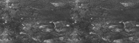
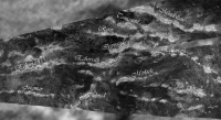
Titan's topography, strange.... |

Titan's topography, strange.... |
 Apr 12 2009, 12:44 PM Apr 12 2009, 12:44 PM
Post
#1
|
|
 Senior Member  Group: Moderator Posts: 2785 Joined: 10-November 06 From: Pasadena, CA Member No.: 1345 |
Recent article in Science by Zebker et al.:
Zebker et al. Science in press, "Size and Shape of Saturn's Moon Titan". doi: 10.1126/science.1168905 (published online April 2, 2009) Link to abstract (pay-for article): http://www.sciencemag.org/cgi/content/abstract/1168905 Article on spaceref discusses this paper: http://www.spaceref.com/news/viewpr.html?pid=27912 Figure 3 from the Science article is a global elevation map relative to barycenter. Key points of article:
"Xanadu seems to be systematically lower than other parts of the equatorial belt, and not uplifted like most mountainous areas on Earth." (quote from Fig. 3 caption in article) -Mike -------------------- Some higher resolution images available at my photostream: http://www.flickr.com/photos/31678681@N07/
|
 |
 
|
 |
|
Apr 12 2009, 03:32 PM
Post
#2
|
||
|
Senior Member Group: Moderator Posts: 2785 Joined: 10-November 06 From: Pasadena, CA Member No.: 1345 |
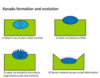
Here's a cartooon showing how Xanadu could have formed:
1) A diapiric rise of warm low density (mostly due to warmth) water ice 2) reaches surface; erosion begins 3) cools and contracts; ice now denser (heavier) than surrounding crust; crustal deformation begins 3) regional depression begins as old diaipir sinks due to now-cooled higher density material Quote from the spaceref article: QUOTE "Zebker said that if you look at images of the surface of Titan, you see surface features that look every bit like mountains on Earth but don't have the high elevations compared to the plains stretching out around them.
'One of the really surprising finds that we have from this, is that the largest apparent continent is lower than the average elevation on Titan, as opposed to higher than the average elevation, as we have on the Earth,' Zebker said. 'My favorite explanation is that the material that forms the mountains is simply more dense than the material surrounding them,' he said. That would result in the mountains pushing down the surrounding crust, effectively putting the mountains in a basin of their own creation. On Earth, the situation is the reverse: The crust that lies under the oceans is denser than the material that makes up the continental crust, where mountain ranges are built up. 'The things that we would expect to exist on the surface of Titan would either be solid hydrocarbon materials, essentially frozen ethane and methane, and that is fairly light, and then frozen water ice, which is denser,' Zebker said. 'If the mountains are composed of water ice and the plain features in between are composed of these solid hydrocarbons, that could lead to this kind of a situation.' " -------------------- Some higher resolution images available at my photostream: http://www.flickr.com/photos/31678681@N07/
|
|
|
|
|
|
|
Apr 12 2009, 03:46 PM
Post
#3
|
||||
|
Senior Member Group: Moderator Posts: 2785 Joined: 10-November 06 From: Pasadena, CA Member No.: 1345 |
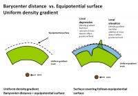
The Science article is in reference to the Barycentric center of Titan.
This could be different from the equipotential surface. If I understand this correctly.... In a perfect world, with a uniform density gradient, the elevation and equipotential surfaces pretty much match:
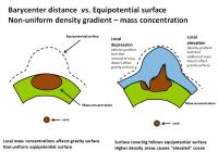
A large mass concentration (high density crustal materials) can cause a localized gravity well, and cause the equipotential surface to bulge out. (More mass, more gravity, more "pull"). So you can get an elevated ocean that covers a elevated (based on barycenter distance) rise.
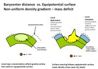
A mass deficit (lower density crustal materials) can cause a localized gravity deficit and cause the equipotential surface to dip in. (less mass, less gravity, less "pull"). This could cause a basin that one would think should be flooded, to be dry. The water table responds to the equipotential surface, not the elevation.
http://en.wikipedia.org/wiki/Geoid -------------------- Some higher resolution images available at my photostream: http://www.flickr.com/photos/31678681@N07/
|
|||
|
|
|
|||
|
Apr 12 2009, 04:00 PM
Post
#4
|
|||
|
Senior Member Group: Moderator Posts: 2785 Joined: 10-November 06 From: Pasadena, CA Member No.: 1345 |
So now a Big Question:
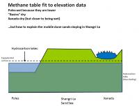
Why are the poles wet, the equatorial Sand Seas dry, and Xanadu dry and sand-free? The elevation difference can explain why the poles are wet:
QUOTE (from Zebker et al. Science in press, "Size and Shape of Saturn's Moon Titan". doi: 10.1126/science.1168905 (published online April 2, 2009): If we posit that the lakes are surface expressions of a more or less continuous liquid organic "water table," then the lower elevations of the poles could lead to the observed preponderance of lakes at high latitudes. However, whether the polar surface intersects a methane table depends on its distance from a constant gravity potential surface, and not the on its elevation from the barycenter, because the equipotential may be depressed as well at the poles. But keeping lower lying downwind Xanadu free from Shangri-La's dune sands is harder to explain. If the equipotential is depressed at Xanadu (due to a lower overall density of crustal materials), this could explain why the mobile dune sands remain in Shangri-La (which is higher barycentric elevation) and don't fill in Xanadu.
Otherwise some funky physical barriers would need to be invoked. [The sand seas could be isolated from the north polar lakes due to many reasons: an isolating temperate airfall deposit, lack of sand reservoirs, lack of winds carrying material into the poles, and also sands getting trapped by the lakes] This Science paper is awesome. It raises a lot of really tough questions..... -------------------- Some higher resolution images available at my photostream: http://www.flickr.com/photos/31678681@N07/
|
||
|
|
|
||
|
Apr 12 2009, 08:24 PM
Post
#5
|
|
|
Senior Member Group: Members Posts: 3516 Joined: 4-November 05 From: North Wales Member No.: 542 |
Thanks for starting off a discussion on this. One fairly safe conclusion would seem to be that for Titan a triaxial ellipsoid is a very poor fit to an equipotential. The latter must be very bumpy compared with what we're used to. But as you say there are problems everywhere with this (which likely means that it will be a very productive observation in the long run). Are Xanadu's mountains dense, or light and porous? We have observational evidence for the latter, yet here it is suggested that they are denser than surrounding terrain and thus capable of making their own basin to sit in.
A general observation (not necessarily helpful): topsy-turvy topography is less difficult to explain away if ALL the surface materials (except the liquids) are of very low density, i.e. fluffy or aerated. |
|
|
|
|
Apr 12 2009, 08:44 PM
Post
#6
|
|
 Member Group: Members Posts: 276 Joined: 11-December 07 From: Dar es Salaam, Tanzania Member No.: 3978 |
Forgive my ignorance ngunn but exactly what was that observational evidence that indicates light and porous material in Xanadu?
-------------------- |
|
|
|
|
Apr 12 2009, 09:03 PM
Post
#7
|
|
|
Senior Member Group: Members Posts: 3516 Joined: 4-November 05 From: North Wales Member No.: 542 |
It came from RADAR reflectance observations of the dielectric properties if I remember correctly. It was a while ago now, but it led to extensive discussion here and elsewhere about possible underground cave systems (likened to Xanadu in the poem). Emily's Planetary Society blog had at least one entry on it at the time, which may or may not have been called something like 'Caverns measureless to man'. Sorry not to be more specific - I wish I was better at keeping references.
|
|
|
|
|
Apr 13 2009, 01:45 AM
Post
#8
|
|
|
Senior Member Group: Moderator Posts: 2785 Joined: 10-November 06 From: Pasadena, CA Member No.: 1345 |
Nigel's right, the most recent evidence comes from a Janssen article on dielectric constant (discussed here: Titan's Mid Latitudes thread, post 6). The dielectric constant in some parts of Xanadu was waaay too low to be of any normal materials, even very low dielectric organics.
Dielectric constant is modified by fluffiness (pores). Volume scattering can make the material appear to have a much lower dielectric constant. It was postulated that volume scattering was responsible for the apparent low dielectric constant. -------------------- Some higher resolution images available at my photostream: http://www.flickr.com/photos/31678681@N07/
|
|
|
|
|
Apr 13 2009, 02:07 AM
Post
#9
|
|
|
Senior Member Group: Moderator Posts: 2785 Joined: 10-November 06 From: Pasadena, CA Member No.: 1345 |
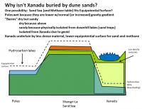
The channel drainage pattern in W Xanadu in the T13 SAR RADAR Swath is very consistent with the Zebker elevation data.
(For E Xanadu, check out Fig 2b the freely available LPSC abstract: http://www.lpi.usra.edu/meetings/lpsc2009/pdf/1037.pdf. For W Xanadu, check out Fig. 7 a and b in Lorenz et al. Planetary and Space Science 56 (2008) 1132-1144. "Fluvial Channels on Titan: Initial Cassini RADAR observations." doi: 10.1016/j.psss.2008.02.009 The dendritic drainage pattern across the T13 RADAR Swath pattern is to the S, towards the lowest regional barycentric elevation determined to be in SW Xanadu. Thus, the elevation data seems to agree with the local geoid in W Xanadu. Back to the tough question, what prevents the Shangri-La dune sands from dropping down into the SW Xanadu low elevation basin??? **** The Zebker paper also makes the airfall origin of the sand sea dunes difficult to explain. If atmospheric deposition and sintering is supposedly occuring all over, it should occur over Xanadu. The regional gradient should make it collect in the SW Xanadu basin. According to this idea, there should be a dune sea filling in the SW Xanadu depression. But there isn't. (At least no dunes are seen by RADAR, and ISS shows a bright coating rather than a dark dune sea.) There is, however, a smooth (RADAR) dark area seen with channels crossing into it, again going downgradient. -------------------- Some higher resolution images available at my photostream: http://www.flickr.com/photos/31678681@N07/
|
|
|
|
|
Apr 15 2009, 03:31 AM
Post
#10
|
|
 Member Group: Members Posts: 611 Joined: 23-February 07 From: Occasionally in Columbia, MD Member No.: 1764 |
QUOTE (Doc @ Apr 12 2009, 04:44 PM)  Forgive my ignorance ngunn but exactly what was that observational evidence that indicates light and porous material in Xanadu? As another post noted, Xanadu has very peculiar dielectric properties - its radar echo is quite depolarized, suggestive of porosity (see the Janssen paper) There is also the result published by Buratti et al of the VIMS team suggesting that the near-IR phase function of Xanadu suggests rougher material (at the microscale, IIRC) |
|
|
|
|
Apr 15 2009, 03:39 AM
Post
#11
|
|
|
Member Group: Members Posts: 611 Joined: 23-February 07 From: Occasionally in Columbia, MD Member No.: 1764 |
QUOTE (ngunn @ Apr 12 2009, 04:24 PM) Thanks for starting off a discussion on this. One fairly safe conclusion would seem to be that for Titan a triaxial ellipsoid is a very poor fit to an equipotential. ... A general observation (not necessarily helpful): topsy-turvy topography is less difficult to explain away if ALL the surface materials (except the liquids) are of very low density, i.e. fluffy or aerated. For your first remark, we'll need to wait to see what the published gravity field is. If the 3rd order terms are, in fact low (at one time the retrievals suggested they might not be), then in fact a triaxial ellipsoid IS a good fit to the EQUIPOTENTIAL. Maybe (since you are referring to the shape measured from radar) you mean that a triaxial ellipsoid isnt a good fit to the figure ? As far as liquids draining downhill goes, there does seem to be a consistency between lakes at high latitudes, and the hint of a tendency (with incomplete sampling) in my fluvial paper for rivers to flow poleward, and the difference between the topographic shape and reasonable geopotentials. The low-latitude longitudinal contrasts (viz, low Xanadu vs the dunes) is harder to explain, as is the orientation of the dunes themselves. I sometimes wonder about albedo-driven wind (i.e. sea-breeze type circulations - with effectively katabatic flow away from high albedo regions). The Zebker et al (you can call me al !) paper about the shape - like the Lorenz et al spin paper last year - is I think just going to be the start of a long and complicated story. |
|
|
|
|
Apr 15 2009, 09:34 AM
Post
#12
|
|
|
Senior Member Group: Members Posts: 3516 Joined: 4-November 05 From: North Wales Member No.: 542 |
On the ellipsoid vs. equipotential I'm happy to be corrected. (I can't pretend I meant something different.) Like you say, we're just at the beginning.
I'm very interested in your idea of albedo-driven winds. For some time I've been trying to shake off habitual assumptions about the importance of gravity in distributing surface materials on Titan. At the Huygens landing site for example there seems to be evidence of fairly recent fluid flow from at least two directions. To me that suggests something like a storm-driven flood, followed up by some gravitational trickling. Of course lighter materials would pay even less heed to gravitational constraint. Even on high-g Earth with heavy silicate sand there is striking evidence that sand seas don't follow equipotentials. The Taklamakhan in western China is a good example. It is much higher at it's western end. I was lucky enough to be there last year and was amazed to see sand 'mountains' piled high on the Pamir plateau, deposited near the head of the steep valley that leads up there from the desert. |
|
|
|
|
Apr 15 2009, 02:34 PM
Post
#13
|
|
|
Senior Member Group: Moderator Posts: 2785 Joined: 10-November 06 From: Pasadena, CA Member No.: 1345 |
Looking at channels in the RADAR Swaths, I haven't seen any obvious places where the apparent flow direction is different from the proposed barycentric elevation differential (Fig 3 in Zebker et al.).
[BTW, the actual swath traces and their altimetry data can be seen in the figures in the text. This was really helpful.] As far as I can tell, the barycentric elevation data seem to fit the equipotential surface (geoid). Why Xanadu is not filled in baffles me... -Mike -------------------- Some higher resolution images available at my photostream: http://www.flickr.com/photos/31678681@N07/
|
|
|
|
|
Apr 15 2009, 03:06 PM
Post
#14
|
|
|
Senior Member Group: Members Posts: 3516 Joined: 4-November 05 From: North Wales Member No.: 542 |
QUOTE (Juramike @ Apr 15 2009, 03:34 PM) Why Xanadu is not filled in baffles me... Perhaps dune particles have a finite lifetime on Titan, and some areas like Xanadu are simply made of the wrong materials for producing them. I agree with your point in an earlier post that they can't be falling from the sky. It has always been awkward to explain how some areas are swept clean if that were the case. |
|
|
|
|
Apr 15 2009, 03:18 PM
Post
#15
|
||
|
Senior Member Group: Moderator Posts: 2785 Joined: 10-November 06 From: Pasadena, CA Member No.: 1345 |
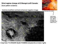
QUOTE (rlorenz @ Apr 14 2009, 10:39 PM) The low-latitude longitudinal contrasts (viz, low Xanadu vs the dunes) is harder to explain, as is the orientation of the dunes themselves. I sometimes wonder about albedo-driven wind (i.e. sea-breeze type circulations - with effectively katabatic flow away from high albedo regions). Here is a detail of the dune pattern near the E Shangri-La/W Xanadu boundary using Amazing Dune-O-Vision (gamma-modified, contrast enhanced, negative image) for a portion of the T13 Swath. I highlighted the dune pattern orientation in some areas using yellow lines.
There seems to be a sudden turn southward near Xanadu as the dunes smack into Xanadu. For a sea-breeze circulation, I would have thought that the off-Xanadu circulation would make the dune pattern "confused" or dissappear in a marginal zone around Xanadu. Instead, while the dune orientation changes, it remains very clear right up until hitting Xanadu. (Also indicating that the Xanadu margin is not much of a topographical barrier) And the dune sand migration seems to bend to the S when it starts to go across Xanadu. Is this vector change sufficient to divert sand flow around the depression instead of into it? Where does the sand eventually end up? -Mike -------------------- Some higher resolution images available at my photostream: http://www.flickr.com/photos/31678681@N07/
|
|
|
|
|
|
|
Apr 15 2009, 03:44 PM
Post
#16
|
|
|
Senior Member Group: Members Posts: 3516 Joined: 4-November 05 From: North Wales Member No.: 542 |
Correct me if I'm wrong (again), but aren't these dunes consistent with winds blowing alternately one way then the reverse? In that case you could in principle have a single longitudinal dune where the wind regime was 60% W, 40% E at one end and 60% E, 40% W at the other. That would fit with the albedo idea, I think, and it would provide geographical confinement for the sand seas.
|
|
|
|
|
Apr 15 2009, 05:10 PM
Post
#17
|
|
|
Senior Member Group: Moderator Posts: 2785 Joined: 10-November 06 From: Pasadena, CA Member No.: 1345 |
If I understand this correctly, the dunes line up along the vector addition product of the alternate wind vectors.
So 50% winds blowing from the NW + 50% winds blowing from the SW will give an EW dune (with the mobile dune particles kinda marching to the E). The change in wind direction could be daily, or seasonal. [http://www.tec.army.mil/research/products/...et/lslinear.htm] (Another clue to average wind direction vector is dune bifurcation, in case of Y-junctions, the "stem" of the Y is downwind.) The key is that to make a stable linear dune, the difference between the two alternate vectors has to be pretty large. Otherwise, the linear dune will decay into a barchan-type dune. Check out: http://www.comphys.ethz.ch/hans/p/457.pdf Extending this to the linear dune direction change to the SSE vector in E Shangri-La/W Xanadu, BOTH alternate wind vectors need to be shifted. So the evidenced wind regime near the margin should be (assuming a 90 degree alternate vector (theta-w) difference) WNW alternating with NNE winds. -------------------- Some higher resolution images available at my photostream: http://www.flickr.com/photos/31678681@N07/
|
|
|
|
|
Apr 15 2009, 05:32 PM
Post
#18
|
|
|
Senior Member Group: Moderator Posts: 2785 Joined: 10-November 06 From: Pasadena, CA Member No.: 1345 |
Two different wind regimes, but with one component larger than the other, can form linear dunes with the vector addition product.
But sand movement will be the time-average of the relative strength of the two alternate regimes. The sand movement vector can be different from the dune alignment vector. Check out this section of a book preview here (Note how the dune pattern changes around Australia due to interaction of winds with the seasonal anticyclonic high. This might be an example of what Ralph was mentioning above, i.e. Xanadu having a permanent pressure system.) -------------------- Some higher resolution images available at my photostream: http://www.flickr.com/photos/31678681@N07/
|
|
|
|
|
Apr 15 2009, 06:06 PM
Post
#19
|
|
|
Senior Member Group: Members Posts: 3516 Joined: 4-November 05 From: North Wales Member No.: 542 |
Mike I'm having trouble reconciling what you describe with the recently published wind vector map where the arrows seem mostly more or less aligned E-W with the dune crests. It is agreed that there is 180 degree ambiguity in the inferred wind direction at any one locality. It has also been suggested that the wind directions could reverse with the tidal cycle. If that's so then presumably material is transported both ways alternately along any particular section of dune. Even a slight preponderence of one direction over the other would be enough to produce the teardrop shapes we see around 'islands', but following the direction inferred at one point could lead you to a place where the preponderance, and therefore the net transport, is the opposite way. There need be no discontinuity in the dune pattern between the two locations, which might be at opposite sides of a sand sea.
I'm sure I'm oversimplifying . . |
|
|
|
|
Apr 15 2009, 07:17 PM
Post
#20
|
|
|
Senior Member Group: Moderator Posts: 2785 Joined: 10-November 06 From: Pasadena, CA Member No.: 1345 |
The maps show the linear dune orientation. The linear dune orientation is based on the averaged wind vector. The alternating winds come from two different directions. These could be daily (tidal) or seasonal.
To make a linear dune, the alternating wind vectors need to be about 90 degrees apart or more. Looking at a linear dune, the averaged wind vector could be in either direction of the line. Looking at the forking pattern can determine which is the correct average direction. The GCM for Titan predicted an overall westerly course for the average winds on Titan (so average wind vector from the E). The observations show an average westerly vector for the surface winds. This is in contrast to the predicted GCM model (by Tokano et al.). Check out: http://www.astronomy.com/asy/default.aspx?c=a&id=7972 And you are correct, a typical sand particle will have a zig-zag path due to the alternating winds, but will run downcrest. If I understand it correctly, a strong wind from one of the alternating components could cause it the particle to "shift" it's path to the next dune set during it's zig-zag path (it zigs more than it zags). Thus the net sand flow could be off-angle to the dune crests. -------------------- Some higher resolution images available at my photostream: http://www.flickr.com/photos/31678681@N07/
|
|
|
|
|
Apr 15 2009, 07:36 PM
Post
#21
|
|
|
Senior Member Group: Members Posts: 3516 Joined: 4-November 05 From: North Wales Member No.: 542 |
QUOTE (Juramike @ Apr 15 2009, 08:17 PM) To make a linear dune, the alternating wind vectors need to be about 90 degrees apart or more. Hope I'm not trying your patience, but this is the bit I don't quite get. What you say implies winds that blow, in general, at angles of 45 degrees or more to the equator. But this is not what Huygens observed, which was roughly E-W movement (parallel to the pair of nearby dunes), with reversals. It also seems at odds with the way we see clouds behaving, forming more or less latitudinal streaks. |
|
|
|
|
Apr 15 2009, 09:40 PM
Post
#22
|
|
|
Senior Member Group: Moderator Posts: 2785 Joined: 10-November 06 From: Pasadena, CA Member No.: 1345 |
If I remember correctly, the GCM wind field changes as Titan goes around Saturn (there is a tidal component). The average vectors predominate from one direction, then alternate with another that is roughly orthogonal.
I'm not sure how this all fits with the Huygens descent data (which also changed direction with altitude): Did the probe descend during a "typical" predominate wind day? Are the winds that Huygens encountered typical of the surface winds? What kind of winds do the banded clouds indicate? (And how do they relate to surface winds?) -------------------- Some higher resolution images available at my photostream: http://www.flickr.com/photos/31678681@N07/
|
|
|
|
|
Apr 15 2009, 09:59 PM
Post
#23
|
|
|
Senior Member Group: Members Posts: 3516 Joined: 4-November 05 From: North Wales Member No.: 542 |
I'm just reading the transcript of the Titan spin CHARM now and it includes an explanation of the dune formation consistent with yours, that is: two wind directions separated by 120-odd degrees. But it also mentions the Tokano et al climate model which has winds switching between W-E and E-W with the seasons (not with the tides - I got that wrong before). So which is it? Do the dune particles move inexorably eastward, albeit by north-south zig-zags, or do they move alternately eastward and westward? The implications of the two are very different.
|
|
|
|
|
Apr 16 2009, 02:45 AM
Post
#24
|
|
|
Senior Member Group: Moderator Posts: 2785 Joined: 10-November 06 From: Pasadena, CA Member No.: 1345 |
From looking at RADAR images, it looks like the W sides of most of the sand seas are lacking in dunes, while the E sides have dunes.
I'd take this as observational evidence that net flow is eastward. -------------------- Some higher resolution images available at my photostream: http://www.flickr.com/photos/31678681@N07/
|
|
|
|
|
Apr 16 2009, 02:46 AM
Post
#25
|
|
|
Senior Member Group: Moderator Posts: 2785 Joined: 10-November 06 From: Pasadena, CA Member No.: 1345 |
Bingo!
Tokano, T. Icarus 194 (2008) 243-262. "Dune forming winds on the surface of Titan and the influence of topography." doi:10.1016/j.icarus.2007.10.007 Pay-for article, abstract available here. QUOTE If Xanadu is a hypothetical large mountain, a wind pattern converging in Xanadu that entirely disagrees with the dune observations is predicted. If instead Xanadu is a large basin, the wind arcs clockwise north of Xanadu and anti-clockwise west and southwest of Xanadu, in agreement with the dune orientations in the vicinity of Xanadu. Here is an additional explanation of the GCM with pretty diagrams: http://www.esa.int/SPECIALS/Cassini-Huygens/SEMF9F9RR1F_0.html ://http://www.esa.int/SPECIALS/Cassini...9F9RR1F_0.html -------------------- Some higher resolution images available at my photostream: http://www.flickr.com/photos/31678681@N07/
|
|
|
|
|
Apr 16 2009, 08:50 AM
Post
#26
|
|
|
Senior Member Group: Members Posts: 3516 Joined: 4-November 05 From: North Wales Member No.: 542 |
QUOTE (Juramike @ Apr 16 2009, 03:45 AM) I'd take this as observational evidence that net flow is eastward. So, four possibilities: 1/ There is a sink of dune particles on the west facing 'coasts'. 2/ On reaching a 'continent' the dune particles skip right over without sticking and start again on the other side. 3/ There is a net eastward flow over much of the sand seas but the net flow reduces to zero at their eastern margins. 4/ Come back in half a million years to see the Xanadu sand sea and the Shangri-la mountains. Nice that the Tokano paper predicted the Xanadu basin - thanks for posting that. |
|
|
|
|
Apr 16 2009, 10:01 AM
Post
#27
|
|
|
Senior Member Group: Members Posts: 3516 Joined: 4-November 05 From: North Wales Member No.: 542 |
A further thought on albedo-controlled winds. Since the dunes themselves are dark, winds that systematically blow from light to dark would constitute a positive feedback mechanism tending to accentuate the separation between light and dark areas. This would be akin to the situation on Iapetus, albeit involving a totally different physical process. All you would need to start it off would be a slight initial tonal dichotomy or a slightly uneven supply of dune forming material.
|
|
|
|
|
Apr 16 2009, 10:32 AM
Post
#28
|
|
|
Senior Member Group: Members Posts: 3516 Joined: 4-November 05 From: North Wales Member No.: 542 |
Let's take this even further into the realm of guesswork. If a computer simulation of this positive feedback system were run it would not surprise me if the light and dark areas evolved towards a state where their EW extent became roughly commensurate with their NS extent. Since the feedback system is confined approximately between 30N and 30S that would lead to 6 alternating light and dark areas ranged around the equator, i.e. 3 major sand seas separated by 3 'continents'. I'd love to see a frequency spectrum of the actual longitude distribution of Titan's sand seas.
|
|
|
|
|
Apr 16 2009, 11:31 AM
Post
#29
|
|
|
Senior Member Group: Moderator Posts: 2785 Joined: 10-November 06 From: Pasadena, CA Member No.: 1345 |
It also means that Xanadu, and processes that operate there, could be a potential source of dune sands.
Since any sands generated in this region would get "swept" away. -------------------- Some higher resolution images available at my photostream: http://www.flickr.com/photos/31678681@N07/
|
|
|
|
|
Apr 16 2009, 11:38 AM
Post
#30
|
|
|
Senior Member Group: Members Posts: 3516 Joined: 4-November 05 From: North Wales Member No.: 542 |
Possibly, but it also restores - or rather preserves - the credibility of the current 'official' hypothesis that the dune particles form in the atmosphere.
|
|
|
|
|
Apr 16 2009, 07:47 PM
Post
#31
|
|
|
Senior Member Group: Moderator Posts: 2785 Joined: 10-November 06 From: Pasadena, CA Member No.: 1345 |
QUOTE (ngunn @ Apr 16 2009, 06:38 AM) Possibly, but it also restores - or rather preserves - the credibility of the current 'official' hypothesis that the dune particles form in the atmosphere. Yup. And if you invoke the sands being able to bounce easily across bright terrain (your item #2), it supports the atmospheric deposition hypothesis. Any atmospheric fallout that hits bright terrain could be blown off. But I'm not sure how this would explain the relatively dune-free W margins of the dune seas. A Xanadu depression makes some of my earlier speculations go bye-bye: it is hard to invoke an earlier sand-sea filling nitrogen ocean without filling in Xanadu as well. -------------------- Some higher resolution images available at my photostream: http://www.flickr.com/photos/31678681@N07/
|
|
|
|
|
Apr 16 2009, 09:52 PM
Post
#32
|
|
|
Senior Member Group: Members Posts: 3516 Joined: 4-November 05 From: North Wales Member No.: 542 |
QUOTE (Juramike @ Apr 16 2009, 08:47 PM) sands being able to bounce easily across bright terrain (your item #2) That wasn't meant to be a serious suggestion. I take it as read that corrugated terrain would be harder for sand to cross than a flat plain. Neither was option 1. (What are we to imagine - critters lining the beaches and eating the stuff?) Option 3 was the serious one, though on reflection you could have a blend of 3 and 4, with a bright albedo obstacle like Xanadu temporarily arresting an inexorable eastward migration of the sands, only to be overwhelmed in a comparatively swift event when eventually the piling up of sand to the west of it becomes just too great and everything moves to it's next quasi-stable position. I have also been thinking about disposal of the atmospheric fallout that lands on Xanadu. In corrugated terrain perhaps not all of it blows clean away. Some could be trapped in pockets or fissures too small for current imaging to resolve and too small also to affect the overall albedo of the region. |
|
|
|
|
Apr 20 2009, 11:07 AM
Post
#33
|
|
|
Senior Member Group: Members Posts: 3516 Joined: 4-November 05 From: North Wales Member No.: 542 |
This thread has gone very quiet! In the meantime I have been trying to put some thoughts into words, and I hope I may be allowed the indulgence of a longer than usual post, even if some of it repeats what's already been said. Here goes:
- - - Ever since we found out that the low latitude dark markings on Titan consist of drifting sands the map of Titan has been giving me a dull headache. It takes sand movement to form and maintain dunes and that means we cannot be looking at a static system. A steady state dynamic system is also ruled out by the presence of a single complete gap in the pattern. Xanadu acts in effect like a giant capacitor blocking the DC flow of sand. The next possibility is AC sand flow - an oscillating system. However, the asymmetries that we see in the sand seas must have taken ages to form, implying a very long time period for the oscillations. There is no obvious driver for such a process. It seems hard to avoid the conclusion that we are looking at a pattern that is somehow being maintained in a non-equilibrium state, hence the headache. Now for the first time that I am aware of we have, in albedo-driven winds (and wind-driven albedos), a process proposed which would involve positive feedback. Positive feedback is exactly what's required to maintain a system in a non-equilibrium state. Positive feedback can give even a feeble or inefficient process the leverage to transform worlds, creating emergent order that makes no sense in other terms. That's why I find this idea so exciting. It raises a host of new questions and the pleasant anticipation that some of them may soon be answered. There is a nice symmetry of scales to this explanation too. Sand dunes and the regular patterns they form are themselves emergent non-equilibrium structures maintained by a different positive feedback system involving wind and another partner, in that case local-scale topography. We are still a long way from knowing that we have the final answer, but that does not worry me at all. I think that at least we can see clearly now what kind of answer we are seeking: a positive feedback mechanism of some sort which can render Titan's sand seas self-confining and its 'continents' self-cleaning. We have in view at last a domain of possible explanations that does not defy reason. The headache is cured. What about the asymmetry of the sand seas and its strong implication of DC sand flow? No problem. We can have eastward drift and positive feedback operating together. This would likely produce a sand flow regime that is continuous at some longitudes and episodic at others where some underlying property of the substrate - very plausibly albedo - dams the flow. The large scale pattern of the sand seas may indeed migrate eastward over long time scales, with Xanadu simply happening to be the most effective dam operating in the particular configuration that prevails in our epoch. - - - I hope Ralph will pay us another visit here and share more of his insights, but even if he doesn't I don't think we've heard the last of this by a long way. |
|
|
|
|
Apr 20 2009, 02:10 PM
Post
#34
|
|
|
Senior Member Group: Members Posts: 3516 Joined: 4-November 05 From: North Wales Member No.: 542 |
A poem:
- - - The Walrus and the Carpenter Were walking close at hand; They wept like anything to see Such quantities of sand: "If this were only cleared away," They said, "it would be grand!" "If seven maids with seven mops Swept it for half a year. Do you suppose," the Walrus said, "That they could get it clear?" "I doubt it," said the Carpenter, And shed a bitter tear. - - - And a piece of music: - - - http://images.google.com/imgres?imgurl=htt...sa%3DN%26um%3D1 |
|
|
|
|
Apr 21 2009, 12:50 AM
Post
#35
|
|
 Member Group: Members Posts: 131 Joined: 30-August 06 From: Moscow, Idaho Member No.: 1086 |
QUOTE (ngunn @ Apr 16 2009, 04:38 AM) Possibly, but it also restores - or rather preserves - the credibility of the current 'official' hypothesis that the dune particles form in the atmosphere. The dune particles do not form in the atmosphere. The atmospheric haze is about 1 micron across, while the sand particles are like 300 microns across. The stuff that falls out of the atmosphere is 300 million times too small (by mass) to form sand-sized grains. The haze must be being reprocessed somehow to get the sand grains. We still don't know how that process works, yet. - Jason |
|
|
|
|
Apr 21 2009, 12:51 AM
Post
#36
|
|
|
Member Group: Members Posts: 131 Joined: 30-August 06 From: Moscow, Idaho Member No.: 1086 |
QUOTE (Jason W Barnes @ Apr 20 2009, 05:50 PM) The dune particles do not form in the atmosphere. The atmospheric haze is about 1 micron across, while the sand particles are like 300 microns across. The stuff that falls out of the atmosphere is 300 million times too small (by mass) to form sand-sized grains. - Jason Check that -- lost an order of magnitude there. Should be 30 million times. - Jason |
|
|
|
|
Apr 21 2009, 02:44 AM
Post
#37
|
|
|
Solar System Cartographer Group: Members Posts: 10163 Joined: 5-April 05 From: Canada Member No.: 227 |
What's an order of magnitude among friends?
Phil -------------------- ... because the Solar System ain't gonna map itself.
Also to be found posting similar content on https://mastodon.social/@PhilStooke Maps for download (free PD: https://upload.wikimedia.org/wikipedia/comm...Cartography.pdf NOTE: everything created by me which I post on UMSF is considered to be in the public domain (NOT CC, public domain) |
|
|
|
|
Apr 21 2009, 03:06 AM
Post
#38
|
|
|
Senior Member Group: Moderator Posts: 2785 Joined: 10-November 06 From: Pasadena, CA Member No.: 1345 |
If Xanadu is "self-clearing" then the dune particles must be going around the southern edge of Xanadu. (The dune pattern in W Xanadu indicates a southern flow)
So you'd expect to see an ISS-dark and RADAR-dark dune sea somewhere along the southern margin...but you don't. One possibility is if there is a temperate/polar bright deposit that forms faster than the dune seas move. So instead of dark dune seas forming, there are bright smooth deposits that form in the temperate regions in south-central Xanadu. In effect the dune seas get "tamped down" and covered up by an ISS-bright atmospheric deposit. So limited "equatorial dunes" in the temperate regions, the deposit seals up the sand supply. So in the big picture of timing of features on Titan, that would imply: Temperate/polar atmospheric deposits>dune seas>other process (save cryovolcanic outlflows) This seems to fit not only Xanadu but the rest of the temperate regions in general. I'll bet that the normalized brightness of Mezzoramia is still not as dark as that of Shangri-La. (Another piece of evidence, look at craterforms: not much in polar/temperate regions, some in dune seas, but pretty much everything exposed in Xanadu) -------------------- Some higher resolution images available at my photostream: http://www.flickr.com/photos/31678681@N07/
|
|
|
|
|
Apr 21 2009, 08:06 AM
Post
#39
|
|
|
Senior Member Group: Members Posts: 3516 Joined: 4-November 05 From: North Wales Member No.: 542 |
QUOTE (Juramike @ Apr 21 2009, 04:06 AM) If Xanadu is "self-clearing" then the dune particles must be going around the southern edge of Xanadu. Not necessarily. There may be no flow across or round Xanadu at this particular epoch but rather a very gradual encroachment at its western margin. When eventually enough of it is covered a lot of sand may cross in a relatively short period. I do think though that there must be some net leakage of sand to temperate latitudes where maybe it becomes damp and less mobile. A lot of dark streaks seem to be diverging from the tropics. RE "The dune particles do not form in the atmosphere" EDITED LAST PARA: I expressed myself sloppily there, and thanks Jason for pointing that out. On the respective particle sizes of haze and sand, I'm not forgetting that there must be a processing step or five to get from the former to the latter, if that is indeed what happens. The point as it relates to this discussion, though, is whether all parts of Titan receive equal doses of the raw material for making sand or whether it has a more localised origin. I was merely pointing out that the albedo winds idea is consistent with virtually any origin for the sand particles, including an atmospheric source for the material, whereas some other conceivable explanations for their uneven distribution might rely on localised sources and sinks. |
|
|
|
|
Apr 21 2009, 03:36 PM
Post
#40
|
|
|
Senior Member Group: Members Posts: 3516 Joined: 4-November 05 From: North Wales Member No.: 542 |
I've just peformed an experiment which crudely simulates what I think happens to the sandflow at Xanadu. It only took a few minutes to set up. No pics unfortunately but here's what I did.
I set up an airtrack at a slight gradient. Above the airtrack I positioned a hairdryer angled slightly downwards but facing the airtrack's uphill direction. Before starting the airflow to the track I placed three pucks well spaced out along it and turned on the hairdryer. On starting the airflow to the track the pucks began moving downhill, remaining evenly spaced. As the first one approached the hairdryer it stopped and reversed back up until the second puck ran into it. Now joined together (blu-tack) the first two pucks came to a halt in front of the hairdryer. When the third puck caught up with the first two they collectively overcame the headwind from the hairdryer and all moved through together. |
|
|
|
|
Apr 21 2009, 04:39 PM
Post
#41
|
|
 Dublin Correspondent Group: Admin Posts: 1799 Joined: 28-March 05 From: Celbridge, Ireland Member No.: 220 |
Very nice work there ngunn - I was struggling to follow the process until you described your own experiment. Very nice demonstration - even if there were no pics.
|
|
|
|
|
Apr 21 2009, 09:54 PM
Post
#42
|
|
|
Senior Member Group: Members Posts: 3516 Joined: 4-November 05 From: North Wales Member No.: 542 |
Glad you liked it. Did you listen to the Takemitsu?
|
|
|
|
|
Apr 22 2009, 07:45 PM
Post
#43
|
|
|
Member Group: Members Posts: 131 Joined: 30-August 06 From: Moscow, Idaho Member No.: 1086 |
QUOTE (ngunn @ Apr 21 2009, 08:36 AM) I've just peformed an experiment which crudely simulates what I think happens to the sandflow at Xanadu. An interesting idea. If this were true, then what we might see would be Barchan dunes racing around Xanadu to the North and South, carrying these spillover sands faster than the longitudinal dunes. I haven't seen this in the VIMS data, but we might reasonably not be expected to given small Barchans and our outrageously crappy spatial resolution near 90W. Does RADAR see anything? My personal best guess right now (subject to change when more data arrive!) is that there is no net sandflow through Xanadu, and that in general W-to-E flux of sand is rather low (but nonzero!). - VIMS Jason |
|
|
|
|
Apr 22 2009, 08:43 PM
Post
#44
|
|
|
Senior Member Group: Members Posts: 1583 Joined: 14-October 05 From: Vermont Member No.: 530 |
QUOTE (Jason W Barnes @ Apr 22 2009, 03:45 PM) My personal best guess right now (subject to change when more data arrive!) is that there is no net sandflow through Xanadu, and that in general W-to-E flux of sand is rather low (but nonzero!). Well, if it's raining 1um grains, and the dunes are 300um, perhaps the 1um stuff blows around on short timescales and corns up into bigger clumps through freeze-thaw cycles. Or something. Snowdrifts definitely don't have the same flake size after just a few days. |
|
|
|
|
Apr 22 2009, 09:37 PM
Post
#45
|
|
|
Senior Member Group: Members Posts: 3516 Joined: 4-November 05 From: North Wales Member No.: 542 |
QUOTE (Jason W Barnes @ Apr 22 2009, 08:45 PM) My personal best guess right now (subject to change when more data arrive!) is that there is no net sandflow through Xanadu, and that in general W-to-E flux of sand is rather low (but nonzero!). The fast-moving mid-latitude barchans is an interesting idea too, but I have a query about your last point. As ever we are bedevilled by our ignorance of timescales for Titan's active processes. Are you saying that unidirectional flow could produce the observed sand sea features yet still be so low that even after hundreds of millions of years (maybe!) the sand would not all have piled up on western Xanadu? For the record what my experiment was attempting to simulate was the periodic overwhelming of Xanadu by a whole sand sea in one big flush, after which (being bright) it would dust itself off quite quickly and remain sand free for perhaps another million years, damming the flow completely as we seem to see it doing now. |
|
|
|
|
Apr 23 2009, 08:01 AM
Post
#46
|
|
|
Senior Member Group: Members Posts: 3516 Joined: 4-November 05 From: North Wales Member No.: 542 |
After sleeping on it I'll now try to be more explicit about why I have difficulty with Jason's quasi-static scenario above.
I have no knowledge of how far sand particles must travel to build a dune sea or the streamlined teardrop shapes around islands, but we can see how far it must have travelled to clear Xanadu. To do that, any sand that formed in the middle of it must have drifted through at least one Xanadu radius. If the global eastward drift were much less than that we would see positive accumulations of sand on [i]both[/ sides of Xanadu, not just the western side. Instead we see a depletion of sand on the eastern side. I think that implies that the global eastward drift at least equals, and may exceed, the flow rate associated with the albedo cleaning process. In other words each sand particle must have drifted, over the history of the sand seas, a distance at least comparable with the dimensions of the sand seas themselves, and possibly much further. That in turn suggests that if Xanadu did not occasionally flush there should by now be a very much bigger pile of sand at its western margin. |
|
|
|
|
Apr 24 2009, 12:39 AM
Post
#47
|
|
|
Member Group: Members Posts: 131 Joined: 30-August 06 From: Moscow, Idaho Member No.: 1086 |
QUOTE (stevesliva @ Apr 22 2009, 01:43 PM) Well, if it's raining 1um grains, and the dunes are 300um, perhaps the 1um stuff blows around on short timescales and corns up into bigger clumps through freeze-thaw cycles. Or something. Snowdrifts definitely don't have the same flake size after just a few days. No -- they tend to agglomerate into ice sheets. At least they do on my driveway if I don't shovel it in time!  Bob Brown at U of Arizona (VIMS Team Leader) suggested that maybe the grains are sintering together like hot metals, and I talk about that briefly in my sand dunes paper. Bottom line is that it's possible, but it would require the right compositional properties and resistance to both erosion and to sintering past the saltation size. And they can't turn into a solid block under the weight of 100 meters of the stuff  - VIMS Jason |
|
|
|
|
Apr 24 2009, 02:27 PM
Post
#48
|
|
|
Senior Member Group: Members Posts: 1583 Joined: 14-October 05 From: Vermont Member No.: 530 |
QUOTE (Jason W Barnes @ Apr 23 2009, 08:39 PM) Bob Brown at U of Arizona (VIMS Team Leader) suggested that maybe the grains are sintering together like hot metals, Both the ice and metal analogies are crystalline. I imagine that this goop wouldn't be. Always have to throw in a "or sumthin'" qualifier because I have no idea what Titan goop really does. Perhaps LN-cold wax is a better analogy. Give it a little heat over a long time period and it'll start sticking together, right? |
|
|
|
|
Apr 24 2009, 03:53 PM
Post
#49
|
|
|
Junior Member Group: Members Posts: 41 Joined: 11-April 07 From: London, U.K. Member No.: 1957 |
"No disrespect," to quote Jon Stewart, but this is why I don't like the application of goo, gloop, etc to Titan. Wax IS crystalline; you can check out some fascinating papers on the crystallography of candle wax by Dorset in Acta Cryst. (e.g., http://dx.doi.org/10.1107/S0108768195005465).
I have every expectation that the ices, hydrates, clathrates, AND the organic solids will be crystalline. I cover this in slightly more detail in my paper in press - http://dx.doi.org/10.1016/j.asr.2008.11.024 |
|
|
|
|
Apr 24 2009, 06:40 PM
Post
#50
|
|
|
Senior Member Group: Moderator Posts: 2785 Joined: 10-November 06 From: Pasadena, CA Member No.: 1345 |
Link for Dorset, Acta Crystallographica B51 (1995) 1021-1028. "The crystal structure of wax."
(Pay for article; no abstract): http://scripts.iucr.org/cgi-bin/paper?S0108768195005465 The authors showed that mixed paraffin waxes after evaporation from light peteroleum ether (mostly pentanes, probably the best room-temperature terrestrial analog for liquid methane) oriented themselves into laminar sheets. When viewed from the side, the position of the carbon atoms is in a hexagonal arrangement (like a sheet of benzenes). The kinks of the chain are evidently 180 degrees out-of-phase with the chain below it. So the distance of 2 adjacent carbons is close, then far, then close as one moves along the chain. The atoms at the center of the chain are pretty locked in, but at the edges the location is more random. (Probably due to voids or other defects since these are mixed component crystals) (The structures in the article were not placed in the Cambridge Crystallographic Database). However, the crystal structure of the more complex beeswax, was much less resolved. Since one would expect multiple functionalities on Titan surface deposit materials (tholin NMR analysis indicates multiple functional groups in the mix), I'd expect that beeswax might be a better analog. [Although some of the functional groups might help orient the molecules in a crystal lattice] Another article mentions that large long chain alkanes with varying lengths compounds can orient themselves in different ways. One form which can cause large voids in the structure. http://scripts.iucr.org/cgi-bin/paper?S0108768195005465 But again, these are long straight-chain boring hydrocarbons. AFAIK, the tholin formation/deposition experiment results have been goopy smears. **** Titan's surface organics are presumably caused either by atmospheric fallout or by chemical reactions from stuff released at the surface (declathrate/reaction) or processing of stuff in hydrocarbon or aqueous solution in the subsurface. Stuff falling out of the atmosphere should be in the amorphous phase (and fluffy). It would need to be reprocessed by either solution (aqueous/organic), pressure or melting to dissolve/reorder/crystallize or reorder/recrystallize the materials. I'm not quite sure I understand the mechanism by which non-volatile dry atmospheric fallout could recrystallize/reorder at 1.5 atm and 95 K. (However, under pressure, in partial-solution, or at higher temperature the grains could agglomerate and recrystallize) -------------------- Some higher resolution images available at my photostream: http://www.flickr.com/photos/31678681@N07/
|
|
|
|
|
Apr 24 2009, 07:41 PM
Post
#51
|
|
|
Senior Member Group: Moderator Posts: 2785 Joined: 10-November 06 From: Pasadena, CA Member No.: 1345 |
Stiles et al. Icarus (2009) ASAP. "Determining Titan surface topography from Cassini SAR Data" doi: doi:10.1016/j.icarus.2009.03.032
Pretty pictures of "seams" along RADAR tracks give detailed elevation data inside the SAR Swaths. (These are also visible in the Science article.) -------------------- Some higher resolution images available at my photostream: http://www.flickr.com/photos/31678681@N07/
|
|
|
|
|
Apr 24 2009, 08:25 PM
Post
#52
|
|
|
Senior Member Group: Members Posts: 3516 Joined: 4-November 05 From: North Wales Member No.: 542 |
A stray thought on the dust-into-sand coagulation process. Could the presence of beta radiation have anything to do with it? Newly fallen dust should be the most radioactive material on the surface of Titan. Any effect would be naturally time-limited, and spatially limited to perhaps a few millimetres.
|
|
|
|
|
Apr 24 2009, 10:50 PM
Post
#53
|
|
|
Junior Member Group: Members Posts: 41 Joined: 11-April 07 From: London, U.K. Member No.: 1957 |
On the crystalline versus amorphous debate
There are some recent laboratory studies of hydrocarbon ices, investigating the amorphous to crystalline transition temperature. These are found to be 70 K in diaceteylene (Zhou et al. in press Planet. Space. Sci. doi:10.1016/j.pss.2009.02.003) and 93 K in vinylacetylene (Kim & Kaiser, 2009, Astrophys. J. Suppl. Ser. 181, 543, doi:10.1088/0067-0049/181/2/543). Since much of Titan's stratosphere is warmer, then one might expect such condensates to be crystalline. There is also observation evidence (IR lattice modes) for crystalline organic ices in Titan's stratosphere - Khanna, 2005a,b (doi:10.1016/j.icarus.2005.02.014 & 10.1016/j.icarus.2005.03.011). I think there's a paper just out by Mike Flasar which reviews this kind of thing. There is also the possibility that amorphous ices might be transformed to a crystalline state by UV radiation, as demonstrated by Chakarov & Kasemo (1998) in Phys. Rev. Lett. 81, 5181. These authors discuss relevance to comets and outer solar system atmosphere. And last of all, we must recall that whilst diffusion rates may be incredibly slow at 95 K, the materials may be kicking about for several billions years. It is likely that any glassy material will devitrify on such timescales, bearing in mind that 95 K is not *that* cold, and water ice is expected to undergo orientational ordering on geological timescales below 70 K. |
|
|
|
|
Apr 24 2009, 11:55 PM
Post
#54
|
|
|
Senior Member Group: Moderator Posts: 2785 Joined: 10-November 06 From: Pasadena, CA Member No.: 1345 |
Good points.
F.M Flasar and R.K Achterberg, Phil. Trans. R. Soc. A February 28, 2009 367:649-664 "The structure and dynamics of Titan's middle atmosphere." doi:10.1098/rsta.2008.0242 Abstract via PubMed here. (I can't access the full article) Link to abstract for Kaiser article mentioned above here Quote from kaiser abstract: QUOTE New laboratory spectra of crystalline and amorphous diacetylene ice have been recorded in the range of 7000500 cm−1 (1.420 μm) to aid in the identification of solid diacetylene on Saturn's moon Titan. We have established that amorphous diacetylene ice is stable only at temperatures less than 70±1 K. So, if it is possible to get atmospheric fallout grains to crystallize/sinter/structurally reorganize into larger grains, does that also imply that over enough time that a stable dune field could also "lock up" and fossilize out? -------------------- Some higher resolution images available at my photostream: http://www.flickr.com/photos/31678681@N07/
|
|
|
|
|
Apr 27 2009, 06:41 PM
Post
#55
|
|
|
Member Group: Members Posts: 131 Joined: 30-August 06 From: Moscow, Idaho Member No.: 1086 |
QUOTE (Juramike @ Apr 24 2009, 04:55 PM) So, if it is possible to get atmospheric fallout grains to crystallize/sinter/structurally reorganize into larger grains, does that also imply that over enough time that a stable dune field could also "lock up" and fossilize out? Possibly so given crystallization and reorganization, but not strictly from sintering alone. The rate of growth for a particle, i.e. dr/dt, is proportional to the radius to the 4th power. So as the sintering grains grow, they do so more and more slowly as a function of time. This can naturally limit their final size to something in the right range, if you tweak the initial parameters properly. - Jason |
|
|
|
|
Apr 27 2009, 09:39 PM
Post
#56
|
|
|
Senior Member Group: Members Posts: 1583 Joined: 14-October 05 From: Vermont Member No.: 530 |
QUOTE (Jason W Barnes @ Apr 27 2009, 02:41 PM) Possibly so given crystallization and reorganization, but not strictly from sintering alone. The rate of growth for a particle, i.e. dr/dt, is proportional to the radius to the 4th power. So as the sintering grains grow, they do so more and more slowly as a function of time. This can naturally limit their final size to something in the right range, if you tweak the initial parameters properly. I was wondering if a little kinetic energy from wind transport helped growth, and that once a particle was too big to be blown around, that it also limited further growth. If those particles are 300um in size, though, that would seem small enough to blow around unless the wind was pretty damn weak. And if they can blow around, that would mean a less fossilized dune field. That must have been discussed here already. Time to use teh google. |
|
|
|
|
May 15 2009, 08:58 AM
Post
#57
|
|
|
Senior Member Group: Members Posts: 3516 Joined: 4-November 05 From: North Wales Member No.: 542 |
The paper is in the current issue of 'Science' out now:
http://www.sciencemag.org/cgi/content/short/324/5929/921 |
|
|
|
|
Sep 26 2009, 09:33 AM
Post
#58
|
||
|
Member Group: Members Posts: 700 Joined: 1-April 08 From: Minnesota ! Member No.: 4081 |
Wow such an incredible discussion ! It is time for some pretty images however.
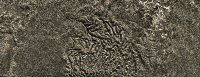
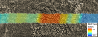
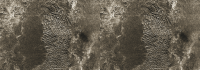
The altimetry data paper of Bryan Stiles et al http://dx.doi.org/10.1016/j.icarus.2009.03.032 published earlier this year did provide sensible correlations for many of the radar swath images although that was not stressed in their paper. Altitudinal data for the T7 swath for example provides a good concordance of downslope gradient and surface flow-fluvial features.
|
|
|
|
|
|
|
Sep 26 2009, 09:44 AM
Post
#59
|
|
|
Senior Member Group: Members Posts: 3516 Joined: 4-November 05 From: North Wales Member No.: 542 |
Brilliant, TR! I think that needs doing for all the SAR swathes.
|
|
|
|
|
Sep 27 2009, 03:38 AM
Post
#60
|
||
|
Member Group: Members Posts: 700 Joined: 1-April 08 From: Minnesota ! Member No.: 4081 |
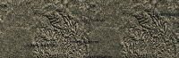
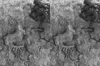
QUOTE (ngunn @ Sep 26 2009, 04:44 AM) Brilliant, TR! I think that needs doing for all the SAR swathes. Now you're really trying to keep me busy!!! I hope you'll settle for just one more, today anyway. The topo map below again takes SAR altimetry data from Stiles paper http://dx.doi.org/10.1016/j.icarus.2009.03.032 and blends it with SAR swath images. The map shows the S poleward portion of T 39 (T39 part 1 in Perry's compilation) from -40 S to -80 S roughly along 210 deg W longitude. Highly dissected terrain with an unusual radar bright basin(?) highlight this swath.
|
|
|
|
|
|
|
Sep 30 2009, 11:34 PM
Post
#61
|
||
|
Member Group: Members Posts: 700 Joined: 1-April 08 From: Minnesota ! Member No.: 4081 |
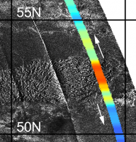
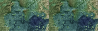
Here's a modified SARTopo map for Adiri and the T8 swath. The relative elevation of Adiri seems apparent. The eastern end has more elevated ridges to the south than the northern end of the swath and this seems evident. The Huygens landing site is in the southern swath portion.
|
|
|
|
|
|
|
Sep 30 2009, 11:41 PM
Post
#62
|
||
|
Member Group: Members Posts: 700 Joined: 1-April 08 From: Minnesota ! Member No.: 4081 |
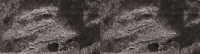
Here's a modified SARTopo map of the Huygens landing site. The last 2 frames embed a copy of Mike's 'vortex distorted' Karkoschka mosaic (PIA08114) highlighting the location.
|
|
|
|
|
|
|
Oct 4 2009, 05:17 PM
Post
#63
|
|
|
Member Group: Members Posts: 700 Joined: 1-April 08 From: Minnesota ! Member No.: 4081 |
QUOTE (titanicrivers @ Sep 30 2009, 06:41 PM) Here's a modified SARTopo map of the Huygens landing site. The last 2 frames embed a copy of Mike's 'vortex distorted' Karkoschka mosaic (PIA08114) highlighting the location. Its interesting how the 'spooky dude' and major fluvial erosion features point in the direction of the lowest portion of the SARTopo (dark blue) swath as one might anticipate. |
|
|
|
|
Oct 4 2009, 06:00 PM
Post
#64
|
|
|
Senior Member Group: Moderator Posts: 2785 Joined: 10-November 06 From: Pasadena, CA Member No.: 1345 |
The "spooky dude" feature still puzzles me. The tapered end points downhill. But the large oval depressions seem to be uphill from the tapered point. This is kinda opposite of what one would expect (I think).
-------------------- Some higher resolution images available at my photostream: http://www.flickr.com/photos/31678681@N07/
|
|
|
|
|
Oct 4 2009, 07:15 PM
Post
#65
|
|
|
Senior Member Group: Members Posts: 3516 Joined: 4-November 05 From: North Wales Member No.: 542 |
Mike, I noticed that you had implied this in one ot two other posts a while back. I've always taken on trust the eastward flow direction inferred in published papers on the landing site, but I have pondered whether I should be sharing your doubts.
For me it is the quasi-elliptical dark lobes that most graphically suggest a formation process for the spooky dude features. I picture each lobe as having been formed by a single huge 'river' of liquid pushing a moraine-like front of debris before it. Where it eventually loses momentum, or most of the liquid has drained into the ground, the debris front is deposited in place acting as a dam. Behind the dam there is still some liquid, and this being somewhat elevated with respect to the outside, some of it trickles through the dam forming small channels draining from inside the ellipse outward. I think this fairly describes what was seen in the few hundred metres around the landing site. What about the pointy ends? Well I've sort of half persuaded myself that if lobe-forming events happen repeatedly over time the loose material will be reworked into different patterns and earlier lobes may be truncated abruptly. Perhaps the points can be explained as bits and pieces of truncated lobes? I agree that this is shaky and I have often thought about staging an experiment to try to reproduce the shapes. I am hopeful that the VIMS landing site paper when it appears (soon?) will shed new light on what materials are actually involved in making these features, and how they might behave when mobile. |
|
|
|
|
Oct 4 2009, 07:58 PM
Post
#66
|
||
|
Member Group: Members Posts: 700 Joined: 1-April 08 From: Minnesota ! Member No.: 4081 |
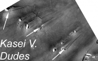
I would also wonder if catastrophic flow was running up against buried, more resilant and perhaps oval shaped calderas in which case one might get the spooky dude shape similar to the 'dudes' pictured below from the Kasei Valles on Mars. On Mars the resilant structures are crater rims. In many examples the upstream rim seems to erode first producing an open half-circle and the stream-lined point looking a bit like Titan's Dudes.
|
|
|
|
|
|
|
Oct 4 2009, 08:31 PM
Post
#67
|
|
|
Senior Member Group: Members Posts: 3516 Joined: 4-November 05 From: North Wales Member No.: 542 |
Against that suggestion I would note that these ovals really are very elongated and seem to be nicely aligned with the flow direction. There are craters and other raised features with leeward tails on Titan, but those do not resemble the spooky dude formation at all. Having said that, the possibility that resistant bedrock contributes part of the morphology, perhaps an important functional part, is also recognised in the literature and I wouldn't dismiss it entirely. My inclination for the moment, though, is to see the whole thing - dark playa material and bright pebbly moraines - as a drift deposit.
|
|
|
|
|
Oct 5 2009, 12:14 AM
Post
#68
|
|
|
Senior Member Group: Moderator Posts: 2785 Joined: 10-November 06 From: Pasadena, CA Member No.: 1345 |
Elevation shows the spooky dude formation is elevated a few hundred meters above the dark deposit.
If it was deposited by catastrophic liquid/mudflow, the stuff couldn't pile up higher than the liquid surface (*I think*). So if the whole shebang was deposited by an E-running liquid flow, it would imply a really, really big catastrophic flow. (Huygens Island is about the same elevation, what would constrain it through this channel at that elevation?) (Glacial moraine deposit is still possible - with the lobes being kettle holes). I think a possible scenario is that the formation was original bedrock, with cavities in the mass. Then a large catastrophic flow came from the E (going W, upgradient) and caused the tapering point towards the E. (An impact driven tsunami's could easily get that high with Titan's low gravity.) As the wave hit, it shaped the formation, and removed much of the loosely consolidated stuff covering the oval cavities on the backside of the formation. (The cavities were that shape pre-tsunami). But I still have just no clue... -------------------- Some higher resolution images available at my photostream: http://www.flickr.com/photos/31678681@N07/
|
|
|
|
|
Oct 5 2009, 01:49 AM
Post
#69
|
|
|
Member Group: Members Posts: 700 Joined: 1-April 08 From: Minnesota ! Member No.: 4081 |
QUOTE (Juramike @ Oct 4 2009, 07:14 PM) Elevation shows the spooky dude formation is elevated a few hundred meters above the dark deposit ... I think a possible scenario is that the formation was original bedrock, with cavities in the mass ... Hmm with that scenario and the current topography favoring a west to east direction, the occassionally fierce flows would extract the sediments and looser material from the cavities once the upstream wall of the formation was eroded and breached. Flow downhill would erode and sharpen the point and one shouldn't need catastrophic flows uphill in that case. |
|
|
|
|
Oct 5 2009, 06:12 AM
Post
#70
|
|
|
Senior Member Group: Members Posts: 3516 Joined: 4-November 05 From: North Wales Member No.: 542 |
QUOTE (Juramike @ Oct 5 2009, 01:14 AM) Elevation shows the spooky dude formation is elevated a few hundred meters above the dark deposit. If it was deposited by catastrophic liquid/mudflow, the stuff couldn't pile up higher than the liquid surface (*I think*). I think most of it is lower than that - more like tens of metres. As far as I know we don't have elevations for the features nearest the probe, but if they were hundreds of metres high we'd see that in the surface view. Also the banks could pile up higher than the liquid if some of the bank materials were buoyant, something that I have long suspected for a variety of reasons. But I have to admit that, like you, I just don't know. |
|
|
|
|
Oct 6 2009, 08:20 PM
Post
#71
|
||
|
Member Group: Members Posts: 700 Joined: 1-April 08 From: Minnesota ! Member No.: 4081 |
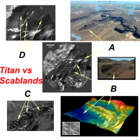
QUOTE (ngunn @ Oct 4 2009, 03:31 PM) Against that suggestion I would note that these ovals really are very elongated and seem to be nicely aligned with the flow direction ... I must confess the more I study the Huygen's channel the more similarities I find to some Earth catastrophic stream carved channel lands but at a smaller scale. Using the Channeled Scablands of the USA state of Washington for comparison one can find A) tapered streamlined elevations pointing downstream with alcoves and basins upstream. B oval scour basins at different elevations C) small channels cut through eroded ridges and D) other streamlined hills and erosional deposits pointing downstream at slightly different angles. If the spooky dudes are rock-hard water ice constructs wouldn't they be expected to be relatively resistant to moderate methane currents that would scour and remove looser non-ice deposits and small ice pebbles like the scabland floods removed loess and softer sedimentary rock while underlying bedrock was partially resistant?
|
|
|
|
|
|
|
Oct 6 2009, 09:03 PM
Post
#72
|
|
|
Senior Member Group: Members Posts: 3516 Joined: 4-November 05 From: North Wales Member No.: 542 |
Interesting comparisons there for sure. I'd like to take the digital terrain model at the bottom right there as a starting point for comments, first of all on the elevations question. That model and another like it form the basis of the statement by Soderblom et al that the bright features within the dark plains are around 100m (not hundreds of metres) high. That particular example shows a feature I have been calling 'the enclosure' some few kilometres southwest of the landing site. An interesting fact about the enclosure is that its interior is higher than the plains around it. Also, in general plan it does not resemble at all what we might call the classical spooky dude shapes with upstream ovals and downstream points. For both of these reasons I think it is actually something intrinsically different. (Your terrestrial analog for that feature is maybe less convincing that your others, which wouldn't be surprising if it is not in fact a flow feature.) The other 3D model shows mainly part of the 'Huygens island' with only a small part of the dark plain. The beach-like features there are actually contiguous with the island and may indeed be structurally part of it. Therefore they too, in my view, are ruled out of the spooky dude club. This means that for the features under discussion we have in fact no elevation data. The dark oval closest to the landing site is about 500 meters wide. It's bright boundary is only tens of metres wide and cannot be more that a few metres high in most places. The wider parts of the 'spooky dude' nearer the pointy end may be a bit higher, or they may not.
I agree with your statement that nothing in the immediate vicinity of the probe seems likely to be bedrock. The VIMS observation should contain pixels entirely filled by spooky dude bright stuff. I expect them to be spectrally distinct from the highlands bright stuff of the Huygens island. EDIT - the 'enclosure' shows up quite clearly on SAR - I think it was one of the features used by Mike and yourself for the most recent attempts at precise registration of the DISR with SAR - whereas the dudes are barely if at all visible, consistent with relatively low relief. |
|
|
|
|
Oct 7 2009, 12:34 AM
Post
#73
|
|
|
Senior Member Group: Moderator Posts: 2785 Joined: 10-November 06 From: Pasadena, CA Member No.: 1345 |
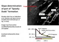
This oval feature shown above is part of the "Spooky Dude" formation. It is the 3rd or fourth oval-thingy over from where the Huygens probe landed.
The center of this feature is 3 km (almost exactly) to the ESE from where the probe touched down. I used the final version of Soderblom's paper (Soderblom et al. Planetary and Space Sci 55 (2007) 2015-2024) and imported the gridded DEM and scale into Photoshop to make absolutely sure of the scale match. The DEM I used is the furthest left figure in Figure 7 of the text. The tippy-top of the ridge is at 180-200 m elevation. The lowest point of the oval-thingy (center of the oval) is at -20-0 m elevation. The difference is between 220-180 m from the bottom of the oval to the top of the (pink) ridge. The green beach in this structure is at 20-40 m elevation. This is about the level of the bright-dark margin. From the top of the (pink) ridge to the (green) beach of the oval, it is an elevation differential of 180-140 m. This is over a horizontal distance of (7.21 pixels x 23 m/pixel) 170 m from the top of the ridge to the beach. The slope angle is between 47 and 39 degrees. (Very steep - this argues against the bright stuff being unconsolidated material). From the beach down to the center of the oval, it is a differential of 80 - 40 m over a horizontal distance of (9.9 pixel x 23 m/pixel) 228 m. Thus the dark stuff is at an angle between 20 and 10 degrees. (The terrain break supports an argument that the dark stuff was deposited or reworked by fluid or that it is unconsolidated stuff.) -Mike -------------------- Some higher resolution images available at my photostream: http://www.flickr.com/photos/31678681@N07/
|
|
|
|
|
Oct 7 2009, 01:11 AM
Post
#74
|
||
|
Senior Member Group: Moderator Posts: 2785 Joined: 10-November 06 From: Pasadena, CA Member No.: 1345 |
Graphic showing elevation trace (based only on the 3 points mentioned above):
-------------------- Some higher resolution images available at my photostream: http://www.flickr.com/photos/31678681@N07/
|
|
|
|
|
|
|
Oct 7 2009, 07:28 AM
Post
#75
|
|
|
Senior Member Group: Members Posts: 3516 Joined: 4-November 05 From: North Wales Member No.: 542 |
Right! Got my position wrong, but the arguments about the morphology being different from the features closer to the probe still remain - no lobes open in the upstream direction or downstream points. Does that feature show up on the radar? Need to look at that again. In this directon the Huygens DISR was looking into the light so genuine bits of highland terrain there would appear different to the Huygens island (which also has internal hollows with outward drainage to the plains like this feature). Roll on that VIMS paper.
Attached File(s)
|
|
|
|
|
Oct 11 2009, 10:35 PM
Post
#76
|
||
|
Member Group: Members Posts: 700 Joined: 1-April 08 From: Minnesota ! Member No.: 4081 |
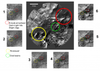
QUOTE (ngunn @ Oct 7 2009, 02:28 AM) Right! Got my position wrong, but the arguments about the morphology being different from the features closer to the probe still remain - no lobes open in the upstream direction or downstream points. Does that feature show up on the radar? Need to look at that again. Taking stills from my animated post # 569 of the Huygens Landing thread I show in the graphic below the spooky dude arrowhead area, the oval basins area and the 'enclosure'. The central figure (the DISR modified Karkoschka image) shows the structures. Side panel #1 shows whats visible in the SAR alone and #2 through #6 overlays the DISR image in increasing amounts to help in identification. The dude arrowhead north edge and 2 hills (one bright one dark) appear, the oval basins are not too visible and dark portions of the enclosure show up. Given the complexity of what makes structures visible in SAR its hard to be definite about the makeup or topography of these structures.
|
|
|
|
|
|
|
Oct 11 2009, 11:10 PM
Post
#77
|
|
|
Senior Member Group: Members Posts: 3516 Joined: 4-November 05 From: North Wales Member No.: 542 |
That's great: I so much prefer a sequence of stills to an animation that can't be slowed down or paused. I'm slightly puzzled by the T8 + T41 SAR there. I'm sure I remember seeing a little bit more in the SAR before. Maybe T8 alone would be better. I think any speculation now will have a short life! I am expecting a 'eureka' moment from the VIMS paper, if not from that long awaited three colour image alone. However I think we have enough already to say that at least two things are going on: catastrophic floods with their depositional and erosional traces plus something else, maybe pre-existing topographic obstacles, the former perhaps less visible to radar than the latter.
Huygens saw pebbles on the ground. I want to know what they're made of - water ice or the bright organic stuff that Cassini sees in highland areas. I think that large parts of the spooky dude formation are likely made of these pebbles, so I'm hoping VIMS will tell us the answer. |
|
|
|
|
Oct 12 2009, 12:43 AM
Post
#78
|
|
|
Senior Member Group: Members Posts: 1276 Joined: 25-November 04 Member No.: 114 |
titanicrivers WOW!
|
|
|
|
|
Oct 12 2009, 02:35 AM
Post
#79
|
|
|
Senior Member Group: Moderator Posts: 2785 Joined: 10-November 06 From: Pasadena, CA Member No.: 1345 |
Nice overlay TR!
I'm not sure if the Spooky Dude formation can be discerned by RADAR. The best SAR gets is 180 m/pixel. The basins are just at the size where a pixel would splat over it. BUT, take a close look at the RADAR-dark but DISR-bright "steaming mass o' something" that is just S of where Huygens landed. That does get picked out by SAR RADAR as a small circular dark spot. (Just to the S of the green circle, 'bout halfway to the bottom of the figure.) That should be visible by VIMS (I hope!) -Mike -------------------- Some higher resolution images available at my photostream: http://www.flickr.com/photos/31678681@N07/
|
|
|
|
|
Aug 25 2010, 02:02 AM
Post
#80
|
||||
|
Member Group: Members Posts: 700 Joined: 1-April 08 From: Minnesota ! Member No.: 4081 |
The recent http://photojournal.jpl.nasa.gov/target/Titan
Planetary Photojournal images of Titans mountains (PIA 13330) are fascinating although well known to UMSF members. I was especially struck by the mountains north of Aaru when I first looked at the T16 radar swath! http://pirlwww.lpl.arizona.edu/~perry/RADAR/#T16 Although photojournal images are well done I thought one might tweak the raws some more to get a better idea of what these landforms look like. Below are 3 views done in photoshop elements using the northern most portion of PIA 13330. The last 3D image was created with a nice shareware program T3D-2D to 3D Image Converter from Cherry Cola Studios using the geometric and parallel 20 weight and shift of 1 reverse depth cue settings. (you'll have to cross your eyes and stare at the middle image until its clear to see the 3D effect !) These mountains seem highly eroded by fluvial processes. Some of the eroding rivers are still prominent, draining into the radar smooth plain to the north.
|
|||
|
|
|
|||
|
Aug 25 2010, 02:28 AM
Post
#81
|
|
|
Senior Member Group: Moderator Posts: 2785 Joined: 10-November 06 From: Pasadena, CA Member No.: 1345 |
Interesting how the channels go to the north into a local minimum, while the regional minimum is directly to the south.
In the images N is to the left, S is to the left. -------------------- Some higher resolution images available at my photostream: http://www.flickr.com/photos/31678681@N07/
|
|
|
|
|
Aug 25 2010, 07:08 AM
Post
#82
|
||
|
Member Group: Members Posts: 700 Joined: 1-April 08 From: Minnesota ! Member No.: 4081 |
QUOTE (Juramike @ Aug 24 2010, 08:28 PM) Interesting how the channels go to the north into a local minimum, while the regional minimum is directly to the south. In the images N is to the left, S is to the left. ... Titan has strange topography but ... N is to the left and S is to the right  in the above figures. in the above figures.Drainage channels appear on either side of the mountains (see fig below) as one might anticipate if the region arose as a plateau and was eroded on both sides. Perhaps the northern facing side had greater fluvial erosion given its more northerly location and current polar atmospheric/weather patterns.
|
|
|
|
|
|
|
Aug 25 2010, 04:17 PM
Post
#83
|
|
|
Senior Member Group: Members Posts: 2998 Joined: 30-October 04 Member No.: 105 |
TR--
Nifty topography. Reminds me of an uplifted plateau that has been dissected. Think of the Grand Canyon area. Minor typo, though: From Post#80: (you'll have to cross your eyes and stare at the middle image until its clear to see the 3D effect !) Should read: (you'll have to cross your eyes and stare at the middle of the (third) image until its clear to see the 3D effect !) You'll go googley-eyed trying to get x-eyed stereo out of the middle image... --Bill -------------------- |
|
|
|
|
Aug 26 2010, 02:21 AM
Post
#84
|
|
|
Senior Member Group: Members Posts: 1276 Joined: 25-November 04 Member No.: 114 |
^ I tried to do the cross eyed thing and my result was a headache!
 Have you done a 3D image? |
|
|
|
|
Aug 26 2010, 08:51 AM
Post
#85
|
||
|
Member Group: Members Posts: 700 Joined: 1-April 08 From: Minnesota ! Member No.: 4081 |
I found this article via Wikipedia that may help you freeview the images and achieve a 3D image that is in focus. Try the example below as its fairly easy to do. The reference article is found here. http://www.angelfire.com/ca/erker/freeview.html
Learning to Cross Eye Freeview: In cross eye freeviewing the image for the left eye is on the right and the image for the right eye is on the left. You stare at a point about 1/2 way to the screen so that your eye's gaze is crossing at the half way point. Thus the left eye sees the correct image which is on the right. As you cross your eyes the image will go double. When your eyes are crossed the correct amount the middle images will overlap and be in 3d. The two outer images will remain and will be in 2d. Try to cross eye freeview view the image below. Hint: be sure to maximize the image window to remove distracting objects like the window border and background text etc.
|
|
|
|
|
|
|
Sep 1 2010, 05:43 AM
Post
#86
|
||
|
Member Group: Members Posts: 700 Joined: 1-April 08 From: Minnesota ! Member No.: 4081 |
Here is another 2D to 3D image that is relatively easy to obtain 3D effect with cross-eye free viewing. The 'Please Register' comment appears because I cannot find a way to purchase this shareware to register it!
The dissected elevated hills near the Huygens landing site as seen by the DISR are emphasized in this view. Both dendritic and rectangular drainage channel patterns are noted. A nice discussion of titan river drainage patterns appears here http://www.planetary.org/blog/article/00002542/
|
|
|
|
|
|
|
Sep 7 2010, 06:27 AM
Post
#87
|
|||
|
Member Group: Members Posts: 700 Joined: 1-April 08 From: Minnesota ! Member No.: 4081 |
N00153307-9 composite with 2D to 3D conversion and Titan and Tethys below provide more examples to try the cross-eye stereoscopic view.
|
||
|
|
|
||
|
Sep 10 2010, 08:31 AM
Post
#88
|
|||
|
Member Group: Members Posts: 700 Joined: 1-April 08 From: Minnesota ! Member No.: 4081 |
N Aaru Mountains, Titan. T16 SAR swath Part2, edited to remove artifacts.
Edit: Now with the 3D version (cross-eyed of course)
|
||
|
|
|
||
|
Dec 6 2010, 06:56 PM
Post
#89
|
||
|
Member Group: Members Posts: 700 Joined: 1-April 08 From: Minnesota ! Member No.: 4081 |
Things are a little slow with Titan at the moment! While waiting for the post T72 storm raws of Titan, I went to a favorite SAR of many of us and constructed a perspective-pseudo-3D version of part of T39. Shown below is a 'cross-eyes' stereo version. Not sure all the apparent topographic hi's and low's are real (have to check Mikes work again) but the area would be an amazing place to visit one day.
|
|
|
|
|
|
|
Dec 7 2010, 01:59 PM
Post
#90
|
|
 Member Group: Members Posts: 656 Joined: 20-April 05 From: League City, Texas Member No.: 285 |
QUOTE (titanicrivers @ Dec 6 2010, 12:56 PM) ...Not sure all the apparent topographic hi's and low's are real... The topography I see seems to relate nicely to the stream networks, though the horizontal ridge spanning the center left of the image may be questionable. I'd enjoy seeing lots more cross-eyed like this, or even entire radar swaths
|
|
|
|
|
Dec 11 2010, 07:46 AM
Post
#91
|
||
|
Member Group: Members Posts: 700 Joined: 1-April 08 From: Minnesota ! Member No.: 4081 |
Agree the horizontal ridge is not compatible with work done by Juramike as beautifully depicted in the channel and valley topic. http://www.unmannedspaceflight.com/index.p...c=6430&st=0
However looking at T39 from another angle and using a Juramike color scheme for topography and applying the 3D conversion yields a better view. The ridge is now a series of eroded buttes and channels hidden in the previous image are in full view. Edit: Sorry all. But I just checked and can't find my red-blue glasses anywhere! (Ya really should keep trying that little school house image a few posts back and it will come. I had to try on medical xrays for a week before I got it the first time.)
|
|
|
|
|
|
|
Dec 11 2010, 09:09 AM
Post
#92
|
|
 Member Group: Members Posts: 593 Joined: 20-April 05 Member No.: 279 |
My head's not wired to do cross-eyed 3d images. Here's my attempt at the above in redcyananaglyphovision
 : : It does look like a fascinating area. Andy |
|
|
|
|
Dec 11 2010, 02:37 PM
Post
#93
|
|
|
Senior Member Group: Moderator Posts: 2785 Joined: 10-November 06 From: Pasadena, CA Member No.: 1345 |
Yeah, my head's not wired for side by side views either.
And it is a very fascinating area, stay tuned... -------------------- Some higher resolution images available at my photostream: http://www.flickr.com/photos/31678681@N07/
|
|
|
|
|
Feb 27 2011, 07:47 AM
Post
#94
|
||
|
Member Group: Members Posts: 700 Joined: 1-April 08 From: Minnesota ! Member No.: 4081 |
Here's a favorite spot on Titan for many of us. (with sincere apologies to those whose eyes cannot cross and focus!)
|
|
|
|
|
|
|
Feb 28 2011, 04:11 PM
Post
#95
|
|
|
Member Group: Members Posts: 656 Joined: 20-April 05 From: League City, Texas Member No.: 285 |
Very subtle topography in this one.
Incidentally, it would be really helpful if something like Stereo Photo Maker were embedded in browsers; perhaps a plug-in for Firefox could be an option someday. Then any stereo image could be adjusted on-the-fly to the preferences of each viewer; generally I don't bother with images posted as anaglyphs unless I'm sufficiently motivated to save them and then view them cross-eyed using SPM. Here's a thought... how about a user preference setting for the UMSF site which displays stereo images per the user's preferences? Apologies if I've drifted too far off-topic. |
|
|
|
|
May 9 2011, 05:13 AM
Post
#96
|
||
|
Member Group: Members Posts: 700 Joined: 1-April 08 From: Minnesota ! Member No.: 4081 |
T8 SAR part 2 contains lots of interesting topography as well as the resting site of the Huygens probe. Below is a cross-eye stereo approximately centered on the touchdown site.
|
|
|
|
|
|
|
Jan 6 2013, 05:58 AM
Post
#97
|
||
|
Member Group: Members Posts: 700 Joined: 1-April 08 From: Minnesota ! Member No.: 4081 |
The recent Photojournal image http://photojournal.jpl.nasa.gov/catalog/PIA16598 locating and naming mountain ranges prompted me to construct this figure from the overlapping SAR's of T8 and T61. The IAU names are from Middle-earth, the fictional setting in fantasy novels by English author J.R.R. Tolkien (1892-1973).
|
|
|
|
|
|
|
Jan 8 2013, 07:33 PM
Post
#98
|
|
|
Member Group: Members Posts: 204 Joined: 14-April 06 From: Seattle, WA Member No.: 745 |
I just saw this on the JPL web site:
Cassini Suggests Icing on a Lake Who would have imagined? Like them, I thought methane ice would sink: "Up to this point, Cassini scientists assumed that Titan lakes would not have floating ice, because solid methane is denser than liquid methane and would sink. But the new model considers the interaction between the lakes and the atmosphere, resulting in different mixtures of compositions, pockets of nitrogen gas, and changes in temperature." I am reminded of Haldane's quote that the "universe may not only be stranger than we imagine" ... though our imagination seems to be doing a good job of keeping up. I look forward to a discussion of this by the experts. Mods: I will let you decide if this needs its own topic. I guess it does relate to Titanian topography. |
|
|
|
|
Jan 8 2013, 10:45 PM
Post
#99
|
|
|
Senior Member Group: Members Posts: 1583 Joined: 14-October 05 From: Vermont Member No.: 530 |
I bet there's some fantastic small-scale topography created by the interaction of liquid flowing over solid. Moulins and ice caves... awesome stuff.
|
|
|
|
|
Jan 9 2013, 04:02 AM
Post
#100
|
|
|
Member Group: Members Posts: 204 Joined: 14-April 06 From: Seattle, WA Member No.: 745 |
Yeah, my mind is quivering with possibilities.
Maybe TiME will have to be an icebreaker. My question is: Is methane (or ethane) ice at this temperature more like wax than the brittle water ice I am familiar with? |
|
|
|
 |

|
Lo-Fi Version | Time is now: 18th May 2024 - 09:54 AM |
|
RULES AND GUIDELINES Please read the Forum Rules and Guidelines before posting. IMAGE COPYRIGHT |
OPINIONS AND MODERATION Opinions expressed on UnmannedSpaceflight.com are those of the individual posters and do not necessarily reflect the opinions of UnmannedSpaceflight.com or The Planetary Society. The all-volunteer UnmannedSpaceflight.com moderation team is wholly independent of The Planetary Society. The Planetary Society has no influence over decisions made by the UnmannedSpaceflight.com moderators. |
SUPPORT THE FORUM Unmannedspaceflight.com is funded by the Planetary Society. Please consider supporting our work and many other projects by donating to the Society or becoming a member. |
|