Locating landers by panoramic horizon imaging |

Locating landers by panoramic horizon imaging |
 Sep 9 2019, 09:35 AM Sep 9 2019, 09:35 AM
Post
#1
|
|
|
Newbie  Group: Members Posts: 18 Joined: 4-January 07 Member No.: 1558 |
Has anyone (for example the great Phil Stooke) ever described a procedure for establishing the location of a lander on a map or orbiter image by reference to peaks seen in horizon images taken by the lander?
This has proved to be a tricky one to search for on the forum although I know individual examples have been discussed both for MER and lunar landers. I thought of this while browsing an entirely different forum https://www.railforums.co.uk/threads/longes...ight-uk.136247/ where sightlines were being discussed, and posters were challenging the identity of horizon features seen from a known location, a sort of reverse problem to that faced on here. |
 |
 
|
 |
|
Sep 10 2019, 08:34 PM
Post
#2
|
||
|
Solar System Cartographer Group: Members Posts: 10146 Joined: 5-April 05 From: Canada Member No.: 227 |
Thanks, John.
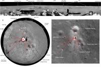
This method is really the same as the standard method for finding your location on Earth by the process of Intersection (A similar method is called Resection). See this example: https://www.armystudyguide.com/content/army...using-int.shtml The more points you can identify the better. Also, here is an illustration of the method for Chang'e 3.
Phil -------------------- ... because the Solar System ain't gonna map itself.
Also to be found posting similar content on https://mastodon.social/@PhilStooke NOTE: everything created by me which I post on UMSF is considered to be in the public domain (NOT CC, public domain) |
|
|
|
|
|
|
Sep 10 2019, 11:22 PM
Post
#3
|
|
 Member Group: Members Posts: 684 Joined: 24-July 15 Member No.: 7619 |
QUOTE (Phil Stooke @ Sep 10 2019, 08:34 PM)  This method is really the same as the standard method for finding your location on Earth ... The more points you can identify the better. Eh, "The Englishman who went up a hill and came down a mountain"... http://www.surveyhistory.org/englishman_wh...t_up_a_hill.htm |
|
|
|
 lollipop Locating landers by panoramic horizon imaging Sep 9 2019, 09:35 AM
 Phil Stooke I don't know about a procedure description, bu... Sep 10 2019, 02:33 AM John Moore Phil...simply a wonderful reply of knowledge to th... Sep 10 2019, 08:48 AM
 |

|
Lo-Fi Version | Time is now: 20th April 2024 - 12:36 AM |
|
RULES AND GUIDELINES Please read the Forum Rules and Guidelines before posting. IMAGE COPYRIGHT |
OPINIONS AND MODERATION Opinions expressed on UnmannedSpaceflight.com are those of the individual posters and do not necessarily reflect the opinions of UnmannedSpaceflight.com or The Planetary Society. The all-volunteer UnmannedSpaceflight.com moderation team is wholly independent of The Planetary Society. The Planetary Society has no influence over decisions made by the UnmannedSpaceflight.com moderators. |
SUPPORT THE FORUM Unmannedspaceflight.com is funded by the Planetary Society. Please consider supporting our work and many other projects by donating to the Society or becoming a member. |
|