MSL "Drive, drive, drive" toward Glenelg, The scientists (mostly) get the keys - sols 38-56 |

  |
MSL "Drive, drive, drive" toward Glenelg, The scientists (mostly) get the keys - sols 38-56 |
 Sep 25 2012, 02:59 PM Sep 25 2012, 02:59 PM
Post
#226
|
||
 Senior Member  Group: Members Posts: 4246 Joined: 17-January 05 Member No.: 152 |
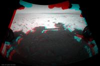
Definitely starting to look interesting as we approach Glenelg. Sol 49 anaglyph:
|
|
 |
 
|
|
|
Sep 25 2012, 03:09 PM
Post
#227
|
|
|
Senior Member Group: Members Posts: 2920 Joined: 14-February 06 From: Very close to the Pyrénées Mountains (France) Member No.: 682 |
I'm starting to think that when Alan Chen said "we've found a nice spot place (for landing)" he was right after all
 Getting rough now -------------------- |
|
|
|
|
Sep 25 2012, 03:25 PM
Post
#228
|
||
 Member Group: Members Posts: 222 Joined: 7-August 12 From: Garberville, CA Member No.: 6500 |
Rough terrain it is... Hazcam from about 3 hrs ago....(Sol 49)...
-------------------- "We shall not cease from exploration, and the end of all our exploring will be to arrive where we started and know the place for the first time." -T.S. Eliot
|
|
|
|
|
|
|
Sep 25 2012, 04:50 PM
Post
#229
|
|
|
Member Group: Members Posts: 252 Joined: 5-May 05 From: Mississippi (USA) Member No.: 379 |
QUOTE (fredk @ Sep 25 2012, 09:59 AM)  Definitely starting to look interesting as we approach Glenelg. Sol 49 anaglyph: That depression, straight ahead, might have some fine grained soil that Curiosity could eat. If it is time for her first meal that is. Jack |
|
|
|
|
Sep 25 2012, 04:55 PM
Post
#230
|
||
|
Senior Member Group: Members Posts: 4246 Joined: 17-January 05 Member No.: 152 |
Long baseline stereo view from sols 19 and 42 (there's some residual headachiness I couldn't get rid of):
|
|
|
|
|
|
|
Sep 25 2012, 05:54 PM
Post
#231
|
|
|
Member Group: Members Posts: 222 Joined: 7-August 12 From: Garberville, CA Member No.: 6500 |
Nice Fred, I almost did that one too as it's one of the few latter day MC100 overlaps from the Sol19 and 23 pans. I'm anxiously awaiting the hi-res versions of the Sol 45 MC100 full panorama of Mt. Sharp to pair with the Sol 23 pano to render the foothills to the south and the slopes above. With that baseline it will be stunning. A handful of the upper slopes came in today. Hoping the rest follow soon... In fact, I went ahead and stitched some of the Sol 45 thumbnails together just to do quick check of level of depth it would provide. It's a little wonky to view because the left eye's red band is quite blurry but it clearly confirms what kind of eye-popping results can be achieved with a Sol 23 & 45 pairing when the full 45's are down.
Here is my very rough and preliminary depth test (left eye is the Sol 45 thumbnail mosaic) : .jpg) When the full resolution version of this can finally be rendered it'll be "chewing gum for the eyes"... -------------------- "We shall not cease from exploration, and the end of all our exploring will be to arrive where we started and know the place for the first time." -T.S. Eliot
|
|
|
|
|
Sep 25 2012, 08:10 PM
Post
#232
|
|
|
Senior Member Group: Members Posts: 2920 Joined: 14-February 06 From: Very close to the Pyrénées Mountains (France) Member No.: 682 |
On today Mars program conference they announced that there will be a Televised Curiosity Science conference this Thursday at 2PM eastern. Stay tuned for Official announcement.
-------------------- |
|
|
|
|
Sep 25 2012, 08:23 PM
Post
#233
|
|
|
Member Group: Members Posts: 139 Joined: 14-October 05 From: Toronto, Canada Member No.: 529 |
An interesting article in Information Week.
Looks like there is a plan for Curiosity to get little sister Opportunity's AEGIS software capability. -------------------- -- Robin
|
|
|
|
|
Sep 26 2012, 12:56 AM
Post
#234
|
|
|
Junior Member Group: Members Posts: 59 Joined: 12-March 10 From: Austin, TX Member No.: 5262 |
In 9 to 12 months, Curiosity will be up in the highlands and probably not roaming long distances or over fields of rocks. Anybody know why not now when it would be most useful on the trek to the hills?
|
|
|
|
|
Sep 26 2012, 02:57 AM
Post
#235
|
|
 Senior Member Group: Admin Posts: 3108 Joined: 21-December 05 From: Canberra, Australia Member No.: 615 |
"Anybody know why not now....." what?
1) Short drives to longer ones later during commissioning/early phases - drivers getting the hang of the vehicle characteristics in an 'alien' environment 2) Challenging terrain - rocks, craters, dust bowls etc 3) It'll take a year to actually get to the hills and there's lots of awesome geology and science inbetween 4) There are dunes and inverted terrain to cross first 5) They'll be climbing in difficult terrain when they do get there 6) Orbitial imagery suggests pretty dusty environs in the valleys, not quite so rocky as out on the plains 7) etc, etc Am I hearing: "Are we there yet?!" from the backseat
|
|
|
|
|
Sep 26 2012, 02:59 AM
Post
#236
|
|
|
Senior Member Group: Members Posts: 4246 Joined: 17-January 05 Member No.: 152 |
Some MR shots are down showing Phobos in the late afternoon sky - here's the best one I noticed:
http://mars.jpl.nasa.gov/msl-raw-images/ms...2000E1_DXXX.jpg Can anyone check to see the altitude of sun and Phobos at the time that was taken? It was taken around 5:30 pm LMST, so the sun was probably very low. Judging from the phase of Phobos, it's probably around 30 degrees from the sun. |
|
|
|
|
Sep 26 2012, 03:04 AM
Post
#237
|
|
|
Member Group: Members Posts: 866 Joined: 15-March 05 From: Santa Cruz, CA Member No.: 196 |
Oh too bad they didn't build AEGIS in from the start!! im guessing it was on the planning board but shelved for perfectly reasonable reasons like risk to the development/launch schedule. But jamming a major upgrade into MSL's package in just 9-12 months does seem ambitious. though risk may seem minimal, unforseen complications and interactions with other elements of the system require vigilant pre-emption through extensive test planning and retesting under various conditions and its good engineering sense to plan on such tasks taking at least 4 times longer than you plan for (the last 20% takes 80% of the work!!)..
Mainly, im guessing they dont want to risk the 1 year "mission success" milestone for MSL and so would rather tack it on after the warranty runs out. As with MER (and i dont know how much testing it got before they popped v1.0 into Oppy), they would have still had a wildly successful 5+ years at 2009, so then if an unfortunate software upgrade croaked the platform, it wouldnt lead to a big media frenzy fiasco like MCO/MPL/DS1 and would have mostly lead to bored UMSF'ers waiting for MSL to touch down...safely.. |
|
|
|
|
Sep 26 2012, 03:39 AM
Post
#238
|
|
|
Founder Group: Chairman Posts: 14432 Joined: 8-February 04 Member No.: 1 |
QUOTE (atomoid @ Sep 25 2012, 07:04 PM) But jamming a major upgrade into MSL's package in just 9-12 months does seem ambitious. On what basis are you saying it's 'jamming'. You don't know how long AEGIS has been worked on at JPL for MSL deployment. You don't know when it started, what the schedule is like, what the testing plan is etc etc. You're talking as if the flight software engineers are morons. They are not. |
|
|
|
|
Sep 26 2012, 03:47 AM
Post
#239
|
|
|
Member Group: Members Posts: 139 Joined: 14-October 05 From: Toronto, Canada Member No.: 529 |
QUOTE (Astro0 @ Sep 25 2012, 09:57 PM) "Anybody know why not now....." what? ... Astro0, I believe Ondaweb was posing his question based on the article on the AEGIS software. His point is, why are they going to wait 9 to 12 month (as per the article) to install the software, when it would be more useful during the approach phase to Mt. Sharp; where we will start doing longer, autonomous, drives. -------------------- -- Robin
|
|
|
|
|
Sep 26 2012, 03:48 AM
Post
#240
|
|
 Member Group: Members Posts: 404 Joined: 5-January 10 Member No.: 5161 |
QUOTE (fredk @ Sep 25 2012, 06:59 PM) Some MR shots are down showing Phobos in the late afternoon sky - here's the best one I noticed: http://mars.jpl.nasa.gov/msl-raw-images/ms...2000E1_DXXX.jpg OMG! I've never seen such an image, such a clear shot of an alien moon taken from the surface of another planet in which the moon is clearly outlined. I know images have been taken showing the other-worldly moons of Mars, and even distant Earth, as mere points of light, wonderful in their own way. But this is a first, is it not? I'm blown away by this image. It's like gazing up at our own moon, yet outrageously different with its not-so-circular crescent through an alien haze. As some on the team said after the first pics came down, the landing place looks familiar. This Phobos moon shot makes it more so. Alright, 'nuff said. |
|
|
|
|

|
Lo-Fi Version | Time is now: 28th April 2024 - 12:26 PM |
|
RULES AND GUIDELINES Please read the Forum Rules and Guidelines before posting. IMAGE COPYRIGHT |
OPINIONS AND MODERATION Opinions expressed on UnmannedSpaceflight.com are those of the individual posters and do not necessarily reflect the opinions of UnmannedSpaceflight.com or The Planetary Society. The all-volunteer UnmannedSpaceflight.com moderation team is wholly independent of The Planetary Society. The Planetary Society has no influence over decisions made by the UnmannedSpaceflight.com moderators. |
SUPPORT THE FORUM Unmannedspaceflight.com is funded by the Planetary Society. Please consider supporting our work and many other projects by donating to the Society or becoming a member. |
|