Roving into the Sulfate Hills, Sol 3200-3387, 6 Aug 2021-16 Feb 2022 |

  |
Roving into the Sulfate Hills, Sol 3200-3387, 6 Aug 2021-16 Feb 2022 |
 Aug 5 2021, 06:24 AM Aug 5 2021, 06:24 AM
Post
#1
|
|
|
Solar System Cartographer  Group: Members Posts: 10145 Joined: 5-April 05 From: Canada Member No.: 227 |
I am starting a new thread for the climb into the hills and valleys of the sulfate unit. I had naively anticipated knowing when a sharp compositional boundary would be crossed, but more likely it will be gradual and the crossing point arbitrary. So the odometer clicking up to 3200 seems like a reasonable place to start a new section. There will be no shortage of amazing views to greet us as we rove on, singing 'sulfates on the soles of our shoes' perhaps.
Start posting here on sol 3200! Phil -------------------- ... because the Solar System ain't gonna map itself.
Also to be found posting similar content on https://mastodon.social/@PhilStooke NOTE: everything created by me which I post on UMSF is considered to be in the public domain (NOT CC, public domain) |
 |
 
|
|
Aug 5 2021, 10:24 AM
Post
#2
|
|
 Senior Member Group: Members Posts: 1079 Joined: 19-February 05 From: Close to Meudon Observatory in France Member No.: 172 |
QUOTE (Phil Stooke @ Aug 5 2021, 08:24 AM)  I am starting a new thread for the climb into the hills and valleys of the sulfate unit. I had naively anticipated knowing when a sharp compositional boundary would be crossed, but more likely it will be gradual and the crossing point arbitrary. So the odometer clicking up to 3200 seems like a reasonable place to start a new section. There will be no shortage of amazing views to greet us as we rove on, singing 'sulfates on the soles of our shoes' perhaps. Start posting here on sol 3200! Phil What a nice idea! Thanks a lot Phil  |
|
|
|
|
Aug 5 2021, 12:02 PM
Post
#3
|
|
|
Junior Member Group: Members Posts: 75 Joined: 8-July 15 Member No.: 7566 |
The rugged terrain Curiosity has reached is arguably the most spectacular landscape ever visited by a Mars rover and I cannot wait for the pictures we are going to get. It'll be a fitting place for Curiosity to spend her final years <3. Can anyone point me to a rough traverse path of where the rover will be headed over the next year or two? I hope we get to return to the pediment soon, the view from up there of the rover's 8-year journey will be amazing I'm sure.
|
|
|
|
|
Aug 5 2021, 12:15 PM
Post
#4
|
|
 Senior Member Group: Members Posts: 2425 Joined: 30-January 13 From: Penang, Malaysia. Member No.: 6853 |
Version 10 of the 'Mount Sharp Ascent Route' (MSAR) is the latest version that I am aware of.
It was documented in an abstract from the 52nd Lunar and Planetary Science Conference. The abstract has several figures that show the path and describe some of the candidate science waypoints along the path. Spoiler alert: They do plan to revisit the Pediment LINKQUOTE (Saturns Moon Titan @ Aug 5 2021, 08:02 PM) ...Can anyone point me to a rough traverse path of where the rover will be headed over the next year or two? I hope we get to return to the pediment soon... |
|
|
|
|
Aug 5 2021, 06:38 PM
Post
#5
|
||
|
Senior Member Group: Members Posts: 2816 Joined: 22-April 05 From: Ridderkerk, Netherlands Member No.: 353 |
The Navcam R view on Sol 3197.
Jan van Driel
|
|
|
|
|
|
|
Aug 5 2021, 06:41 PM
Post
#6
|
|
|
Senior Member Group: Members Posts: 2998 Joined: 30-October 04 Member No.: 105 |
QUOTE (Phil Stooke @ Aug 5 2021, 01:24 AM) I am starting a new thread for the climb into the hills and valleys of the sulfate unit. I had naively anticipated knowing when a sharp compositional boundary would be crossed, but... Phil Likely with all the float moving downslope we won't see a sharp boundary. We can keep looking for undisturbed outcrops not at the head of talus slopes and close enough to zap with the Chemcam. Astounding journey... --Bill -------------------- |
|
|
|
|
Aug 8 2021, 03:37 AM
Post
#7
|
||
|
Senior Member Group: Members Posts: 2425 Joined: 30-January 13 From: Penang, Malaysia. Member No.: 6853 |
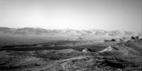
May as well kick off this thread properly with this majestic view from one of the NavCam during sol 3200
|
|
|
|
|
|
|
Aug 8 2021, 07:30 AM
Post
#8
|
|
|
Solar System Cartographer Group: Members Posts: 10145 Joined: 5-April 05 From: Canada Member No.: 227 |
Incredible! The atmosphere has really cleared up. A few months ago you could hardly see the hills.
Phil -------------------- ... because the Solar System ain't gonna map itself.
Also to be found posting similar content on https://mastodon.social/@PhilStooke NOTE: everything created by me which I post on UMSF is considered to be in the public domain (NOT CC, public domain) |
|
|
|
|
Aug 9 2021, 03:27 PM
Post
#9
|
||
|
Senior Member Group: Members Posts: 2816 Joined: 22-April 05 From: Ridderkerk, Netherlands Member No.: 353 |
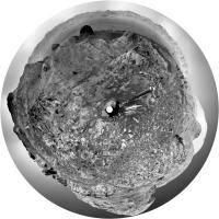
The Navcam R view on Sol 3202.
Jan van Driel
|
|
|
|
|
|
|
Aug 9 2021, 06:41 PM
Post
#10
|
||
|
Solar System Cartographer Group: Members Posts: 10145 Joined: 5-April 05 From: Canada Member No.: 227 |
Jan's panorama in circular form:
Phil
-------------------- ... because the Solar System ain't gonna map itself.
Also to be found posting similar content on https://mastodon.social/@PhilStooke NOTE: everything created by me which I post on UMSF is considered to be in the public domain (NOT CC, public domain) |
|
|
|
|
|
|
Aug 10 2021, 11:47 AM
Post
#11
|
||
|
Senior Member Group: Members Posts: 2816 Joined: 22-April 05 From: Ridderkerk, Netherlands Member No.: 353 |
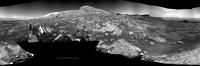
The Mastcam L view on Sol 3201.
Jan van Driel
|
|
|
|
|
|
|
Aug 10 2021, 11:50 AM
Post
#12
|
||
|
Senior Member Group: Members Posts: 1074 Joined: 21-September 07 From: Québec, Canada Member No.: 3908 |
Sol 3202 Rmastcam:
|
|
|
|
|
|
|
Aug 11 2021, 12:50 AM
Post
#13
|
|
 Senior Member Group: Members Posts: 1887 Joined: 20-November 04 From: Iowa Member No.: 110 |
Interesting color contrast between the cap and the lower layers.
|
|
|
|
|
Aug 11 2021, 05:10 PM
Post
#14
|
||
|
Senior Member Group: Members Posts: 2816 Joined: 22-April 05 From: Ridderkerk, Netherlands Member No.: 353 |
The Navcam R view on Sol 3203.
Jan van Driel
|
|
|
|
|
|
|
Aug 11 2021, 08:24 PM
Post
#15
|
||
|
Junior Member Group: Members Posts: 75 Joined: 8-July 15 Member No.: 7566 |
And we have almost arrived at the pediment already! The resistant capstone at the top of the cliff in front of us is indeed the Greenheugh pediment I have overlaid the MSAR_10 route (the most recent strategic route) to show roughly where the team probably intends to ascend up onto the pediment. From the looks of the planned traverse, the rover will follow this cliff uphill, squeezing through a narrow passage and then ascending a ramp. However, before all that I expect they'll want to drill nearby to where we are now, to document the chemistry of the rocks directly underneath the pediment. Once we're ontop, the view will be very special. Looks like they plan on sending the rover towards that big ridge that runs down the middle of it - my understanding is that there's debate over whether the Greenheugh pediment represents just aeolian sandstones, basically a lateral continuation of the stimson formation (remember the buttes all those years ago?), alternatively it might be an alluvial fan. It certainly resembles a fan in shape and that big ridge running down the middle could be an inverted channel. This is why the mission geologists want to send the rover there, to check which theory's true!
|
|
|
|
|
|
|

|
Lo-Fi Version | Time is now: 16th April 2024 - 05:47 AM |
|
RULES AND GUIDELINES Please read the Forum Rules and Guidelines before posting. IMAGE COPYRIGHT |
OPINIONS AND MODERATION Opinions expressed on UnmannedSpaceflight.com are those of the individual posters and do not necessarily reflect the opinions of UnmannedSpaceflight.com or The Planetary Society. The all-volunteer UnmannedSpaceflight.com moderation team is wholly independent of The Planetary Society. The Planetary Society has no influence over decisions made by the UnmannedSpaceflight.com moderators. |
SUPPORT THE FORUM Unmannedspaceflight.com is funded by the Planetary Society. Please consider supporting our work and many other projects by donating to the Society or becoming a member. |
|