Mars software |

  |
Mars software |
 Apr 26 2006, 06:51 PM Apr 26 2006, 06:51 PM
Post
#1
|
|
|
Member  Group: Members Posts: 147 Joined: 14-April 06 From: Berlin Member No.: 744 |
I have read about the Midnight Mars Viewer but I work on ancient computers here and it could not possibly fit on any of the tiny hard drives not to mention extreme RAM deficiency. I am looking for a neat LITTLE thingy that would show me a map of Mars with certain degree of interactivity (daylight, landing sites etc. would be nice). And yes, I know these guys:
http://www.merid.cam.org/meridian/index.html http://skyandtelescope.com/resources/softw...ticle_328_2.asp http://pds-rings.seti.org/tools/viewer2_mar.html So, any nice little thingy links anyone? Regards, Karol P. -------------------- |
 |
 
|
|
Apr 26 2006, 07:27 PM
Post
#2
|
|
 Dublin Correspondent Group: Admin Posts: 1799 Joined: 28-March 05 From: Celbridge, Ireland Member No.: 220 |
Celestia will run on a Win95 SE machine with 64Meg of RAM and less than a hundred meg of disk space.
It will show you as much detail as you want and is plenty accurate for your purposes. The one requirement is a reasonably capable 2nd generation 3D graphics card (Something like an Nvidia TNT) but pretty much any video card produced since around 2000 will manage the basic rendering option. |
|
|
|
|
Apr 27 2006, 12:48 AM
Post
#3
|
|
 Senior Member Group: Moderator Posts: 2262 Joined: 9-February 04 From: Melbourne - Oz Member No.: 16 |
Celestia is hardly LITTLE though!
 But well worth it if you can get it running. But well worth it if you can get it running.Seeing your comment "daylight, landing sites etc." made me immediately think of Mars24 which does that at least. James -------------------- |
|
|
|
|
Apr 27 2006, 09:24 AM
Post
#4
|
|
|
Member Group: Members Posts: 147 Joined: 14-April 06 From: Berlin Member No.: 744 |
Thank you for your quick answers but I already know Celestia and Mars 24. As for Celestia, I am looking for something Mars-specific and less demanding when it comes to graphics - oh yes, the only computers that I can access conveniently are from before 2000. As for Mars 24, it does show landing sites but only the NASA ones. I was thinking more of something really tiny, a bit like Meridian but more sophisticated. On the USGS website there is a great, higly accurate, detailed MOLA map colorised for elevation but it is only a Mercator style map in a PDF file and it would be great if someone could turn it into an interactive application with the surface features actually projected onto a globe which can be turned and viewed from above or below, zoomed and maybe even have some search features. It is amazing what ingenious software people come up with nowadays and I thought someone has already created that kind of software.
-------------------- |
|
|
|
|
Apr 27 2006, 12:19 PM
Post
#5
|
|
|
Dublin Correspondent Group: Admin Posts: 1799 Joined: 28-March 05 From: Celbridge, Ireland Member No.: 220 |
QUOTE (karolp @ Apr 27 2006, 09:24 AM)  It is amazing what ingenious software people come up with nowadays and I thought someone has already created that kind of software. Sounds like a nice exercise for someone to take on if it hasn't been done already. It wouldn't be trivial but it should be possible to build a very compact general purpose "sphere" viewer that needed very little hardware horsepower that could then have things like a Mars Map and location information textured over it. I'd volunteer but graphics rendering apps are not my thing, it would be fun though. I wanted to build a general purpose engine to visualise Mars at once time, ideally using the MOLA maps as the base structure but then I discovered Celestia and kind of lost the impetus. |
|
|
|
|
Apr 27 2006, 06:27 PM
Post
#6
|
|
|
Member Group: Members Posts: 147 Joined: 14-April 06 From: Berlin Member No.: 744 |
I have just stumbled upon just that: a 3d engine with superimposed texture:
http://planetarium.civ.pl/downland/uklad.php (position No. 2 in the software list). It does not have any names on it though and is kind of slow at rendering things. -------------------- |
|
|
|
|
Apr 28 2006, 12:17 AM
Post
#7
|
|
|
Senior Member Group: Moderator Posts: 2262 Joined: 9-February 04 From: Melbourne - Oz Member No.: 16 |
QUOTE (karolp @ Apr 27 2006, 07:24 PM) As for Mars 24, it does show landing sites but only the NASA ones. That's not true, it includes Beagle 2 and Mars 2/3/6, plus a whole load of surface features. -------------------- |
|
|
|
|
Apr 28 2006, 03:58 PM
Post
#8
|
|
 Senior Member Group: Members Posts: 1281 Joined: 18-December 04 From: San Diego, CA Member No.: 124 |
I think this the right place to post this, but it looks like a newer version of Terragen in in the pipeline:
Terragen 2 Technology Preview Release Announcement  Some great work has been done with the older version here. -------------------- Lyford Rome
"Zis is not nuts, zis is super-nuts!" Mathematician Richard Courant on viewing an Orion test |
|
|
|
|
Apr 28 2006, 08:50 PM
Post
#9
|
||
 Senior Member Group: Members Posts: 2488 Joined: 17-April 05 From: Glasgow, Scotland, UK Member No.: 239 |
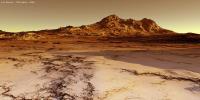
QUOTE (lyford @ Apr 28 2006, 04:58 PM) I think this the right place to post this, but it looks like a newer version of Terragen in in the pipeline: Terragen 2 Technology Preview Release Announcement Some great work has been done with the older version here. Lyford: I've had lots of fun in the past with both VistaPro and Terragen and look forward to TG2! Here's a quick play with one of Luc Bianco's images of a (Terrestrial) icy landscape (the original is at: http://lucbianco.free.fr/3D/TGD12.jpg): Bob Shaw
Attached thumbnail(s)
-------------------- Remember: Time Flies like the wind - but Fruit Flies like bananas!
|
|
|
|
|
|
|
Apr 28 2006, 09:07 PM
Post
#10
|
|
|
Senior Member Group: Members Posts: 1281 Joined: 18-December 04 From: San Diego, CA Member No.: 124 |
Wow that turned out pretty nice!
Now we just have to add a rover to it 
-------------------- Lyford Rome
"Zis is not nuts, zis is super-nuts!" Mathematician Richard Courant on viewing an Orion test |
|
|
|
|
Apr 29 2006, 01:33 PM
Post
#11
|
|
|
Member Group: Members Posts: 147 Joined: 14-April 06 From: Berlin Member No.: 744 |
QUOTE (jamescanvin @ Apr 28 2006, 02:17 AM) That's not true, it includes Beagle 2 and Mars 2/3/6, plus a whole load of surface features. Oops, sorry about that. The older landers are not displayed as default though. -------------------- |
|
|
|
|
Sep 24 2007, 01:30 AM
Post
#12
|
|
|
Senior Member Group: Members Posts: 1074 Joined: 21-September 07 From: Québec, Canada Member No.: 3908 |
A few months ago I stumbled upon a website where you could download a program that permits you to navigate around Mars (kind of what Google Earth does) using actual data from Mars. There was a video showing a zoom into Victoria crater and moving around the crater in a 3D view. Unfortunately, I didn't bookmark the site, and I can't find it anymore. The software was called something like "Malathea" or "Galathea". I think it was developed by a group in a university. Any of you know anything about that?
Thanks for any help. |
|
|
|
|
Sep 24 2007, 01:59 AM
Post
#13
|
|
|
Senior Member Group: Members Posts: 2511 Joined: 13-September 05 Member No.: 497 |
QUOTE (charborob @ Sep 23 2007, 06:30 PM) The software was called something like "Malathea" or "Galathea". I think it was developed by a group in a university. Not a HHGTTG fan, eh?  That would be Magrathea: http://www.magrathea-engine.org/v2/index.php?lang=en -------------------- Disclaimer: This post is based on public information only. Any opinions are my own.
|
|
|
|
|
Sep 24 2007, 04:39 AM
Post
#14
|
|
 Senior Member Group: Members Posts: 3419 Joined: 9-February 04 From: Minneapolis, MN, USA Member No.: 15 |
Ah, but did they make the sky *just* the right shade of pink?
 -the other Doug -------------------- The trouble ain't that there is too many fools, but that the lightning ain't distributed right. -Mark Twain
|
|
|
|
|
Sep 24 2007, 01:35 PM
Post
#15
|
|
|
Senior Member Group: Members Posts: 1074 Joined: 21-September 07 From: Québec, Canada Member No.: 3908 |
QUOTE (mcaplinger @ Sep 23 2007, 09:59 PM) Yes, that's it. Thanks. What is HHGTTG? |
|
|
|
|

|
Lo-Fi Version | Time is now: 25th April 2024 - 01:48 AM |
|
RULES AND GUIDELINES Please read the Forum Rules and Guidelines before posting. IMAGE COPYRIGHT |
OPINIONS AND MODERATION Opinions expressed on UnmannedSpaceflight.com are those of the individual posters and do not necessarily reflect the opinions of UnmannedSpaceflight.com or The Planetary Society. The all-volunteer UnmannedSpaceflight.com moderation team is wholly independent of The Planetary Society. The Planetary Society has no influence over decisions made by the UnmannedSpaceflight.com moderators. |
SUPPORT THE FORUM Unmannedspaceflight.com is funded by the Planetary Society. Please consider supporting our work and many other projects by donating to the Society or becoming a member. |
|