Printable Version of Topic
Click here to view this topic in its original format
Unmanned Spaceflight.com _ Spirit _ Home Plate Speculations
Posted by: dvandorn Jan 25 2006, 04:10 PM
Down in the Front Page Stories board, Phillip asked what all of us UMSF types think Home Plate might be made of and how it was formed. He actually wants Jim Bell's speculations, but asked for UMSF's speculations, as well.
Since we're getting close to getting there, it's time for any of your uninformed speculations out there to be recorded for all posterity... 
I posted the following in that thread, but it really belongs here, so I'm reposting it here and inviting discussion. I figure that a lot of us don't bother to read the boards we don't stay actively involved with, so for all of you, this is new. Otherwise, I apologize for the repetitiion!
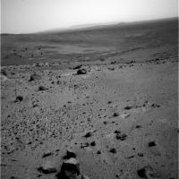
Look at the vertically-exaggerated image posted http://www.unmannedspaceflight.com/index.php?act=Attach&type=post&id=3572.
Home Plate seems very obviously, in this stretched image, to be the remnant of an impact crater. There are several impact crater remnants in the inner basin, here. Each seems to have been formed in a surface that was a good many meters higher than the present surface -- those missing several meters have been deflated from this terrain, by some process, leaving the shocked "pedestal" remnants of the deeper cratering forms.
Remember, when you make an impact crater, you don't just affect the surface. The disruption caused by the cratering event goes well under the surface, consisting of impact melt (if the impact is energetic enough) and shocked, brecciated rocks.
The crater remnants we're seeing on the surface look like the brecciated and shocked rocks that were originally created in a bowl-shaped lining beneath this cluster of impact craters. I can see traces of at least five different craters within the inner basin, here. (The ridge of rock Spirit is passing right now is, in fact, a small crater remnant.)
As for Home Plate, it sits within the largest and most well-defined of these crater remnants. Maybe such layers were exhumed in *all* of the craters here, and have since been completely eroded away -- but that doesn't seem right. We have traces of several craters, and in only one of them do we see any trace of this lighter-colored material.
I'd have to think that either the impact target composition was different where the Home Plate impact occurred -- which seems a little unlikely when you consider some of these impacts are only a few tens of meters apart -- or that some other substance was deposited in Home Plate crater that wasn't deposited in the other craters. (Or that has been completely deflated from the other craters, if it ever existed there.)
So, logic *seems* to point towards post-cratering material deposition accounting for the light-rock ring. Personally, I think it could have been water deposition. Home Plate could have been a puddle that was filled and dried thousands of times (maybe with an internal artesian spring) that resulted in aqueous transport and deposition.
Or, it could have just been a good wind trap and it trapped a lot of light-colored dust. Hard to say.
I'm not only interested in the light-rock ring's composition, I'm getting very curious about the erosion process that deflated the original surface. Could aeolian erosion have deflated *that* much surface, even over a few billion years? Do we need to postulate aqueous erosion, or even glacial erosion?
Maybe the specific composition and erosion patterns we see on the light-rock ring will help us puzzle that out.
-the other Doug
Posted by: general Jan 25 2006, 04:38 PM
Eroded core of a volcano
Posted by: Marz Jan 25 2006, 04:45 PM
Or, it could have just been a good wind trap and it trapped a lot of light-colored dust. Hard to say.
-the other Doug

I'd agree that Homeplate most resembles the exumed floor of an impact basin, but there are a few inconsistencies:
1. why is the SE "rim" sheared off in a straight line?
2. why isn't there more craters in Gusev that show homeplate-like features? It seems too enigmatic.
3. Bonneville was an excellent sand trap, but it's floor didn't look like this, so I think the sand-trap theory is not as likely, but maybe a crater floor with a puddle... but again, why would this be the only crater to form evaporites?
Thanks for opening the speculation flood gates!
Posted by: Bill Harris Jan 25 2006, 04:52 PM
Good question, but we won't know for sure until we can thwack Homeplate.
My thoughts are that Homeplate and the several light "layered deposits" are erosional remnants of a widespread unit that has been deflated or eroded.
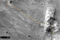
I have a map on this board, adapted from Alan's route map, that ties the Homeplate to the scattered layered unit outcrops. I can't find it on the board right now, but I have it on my home 'puter and will post it later tonight.
I think that Homeplate might be the bowl of a paleocrater, but we need to find impact breccia, shattercones, etc first.
Put me down for a definite maybe...
--Bill
Posted by: Phil Stooke Jan 25 2006, 04:53 PM
Very interesting topic - and a good idea to move it here.
It's not so clear to me that HP is a crater remnant. Admittedly it looks a bit like it in the image Doug linked to. But what about all the other light material on the way, especially just before Comanche? In fact, Comanche seemed to be superimposed on bright stuff, stratigraphically higher. Is HP part of a much wider layer? If so, what is it?
Just as a working hypothesis I'll throw out this possibility. The hills are a composite of multiple layers of ejecta, volcanic ash from Apollinaris or elsewhere, and maybe wind-deposited material, stacked up over hundreds of millions of years after Gusev formed. They were sculpted by small impacts (Inner Basin, East Basin etc.). A brief flood - more like a mudflow - from Ma'adim Vallis soaked the area, but never really formed a lake. Later the basalts of the actual landing area flooded part of the Gusev floor. Since then small impacts like Castril and Bonneville have scattered ejecta over everything. Deflation acting over 3 Gy has gradually eaten away at the hills, which were never consolidated and deflate faster than the basalt plains.
HP would be part of one such layer. I don't know what it is, but let's say for sake of argument it's a layer of fine volcanic ash deposited over an irregular surface within the stack of ejecta etc comprising the hills. Other parts of the same formation are visible around (under) Comanche. It will be altered by exposure to water. Now it's being exhumed by aeolian action in several places. Maybe HP itself is a place where the layer was deposited in an old depression and has been preserved better than elsewhere.
Just a guess!
To my mind one of the most interesting things about this will be looking for stratigraphic contacts. Can we see where the HP material sits right on top of the underlying stuff? I have a hunch that the NW corner of it exposes a section at least a meter or two high. That would be my first priority.
Phil
Posted by: john_s Jan 25 2006, 06:03 PM
I suspect Phil is exactly right. Homeplate is probably an unusually symmetrical remnant of one of the light-colored layers like the ones we've been traversing on the way down from Husband Hill, maybe preserved because it's at a low point in the undulations that are apparent in the layers throughout the Columbia Hills.
I still don't understand all these undulations though- most deposition mechanisms would form fairly horizontal layers initially (draping over existing topography is possible, but usually the deposited stuff just collects in the depressions, and doesn't form a uniformly thick mantle over everything). It's not clear to me how impacts could warp the layers in the broad, coherent way that we see.
Posted by: The Messenger Jan 25 2006, 07:26 PM
Given the clean lines on the rim, I would go with a snapped off fossilized Sequia - notice the proturding serpentine root structure 
Seriously, I vote for a volcanic origin for this very reason: The serpentine hills surrounding homeplate could be volcanic in nature...either that or the grounds keeper left the hose out and running, and it sunk into the mud.
Very curious feature.
Posted by: space_student Jan 25 2006, 07:33 PM
Just to throw out an alternate hypothesis, perhaps Home Plate is a megablock excavated by some large impact event. As for composition, it can certainly end up being volcanic ash, but a far more exciting possibility would be lacustrine deposits from the ancient lake in Gusev crater, which is what Spirit was originally sent to find.
Posted by: general Jan 25 2006, 07:39 PM
Could these strange 'sandwich'rocks be an indication of what HP might be? They look like layers of pumice and petrified ash (?)
http://qt.exploratorium.edu/mars/spirit/pancam/2006-01-24/2P191347156EFFAN00P2555L7M1.JPG
Posted by: Bill Harris Jan 25 2006, 07:40 PM
I wouldn't be suprised if, just as the Homeplate formation is draped over a wide area of the Inner Basin, the unit now typified by Comanche is present as erosional remants overlying that lower Homeplate unit, visible as the "Pitcher's Mound", the hill just south of the Ultreya dunes, and other spots in the Inner Basin. Look at Alan's vertically exaggerated Route Map of the Inner Basin.
--Bill
Posted by: MaxSt Jan 25 2006, 09:09 PM
I think Home Plate is very salty.
Posted by: algorimancer Jan 25 2006, 09:50 PM
Odds are that it is evaporite, with volcanic ash blended-in. However, have we ruled-out water ice with any confidence? That is, has the remote sensing from on top of the hill (and orbit) been sufficient to look for H20 and determine it was absent? If not, the structure and geography might suggest an ice plug above a spring (I believe a spring would be required to maintain an exposure of ice at this latitude). Not likely, but just at the moment I wouldn't rule it out.
Posted by: RNeuhaus Jan 26 2006, 04:09 AM
I put my toughts on the following.
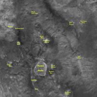
The Home Plate is not a good oval or circle in as an impact factor. I am not considering this as an impact origin. On the other hand, the HP has light color surface and it is not only one but there is another similar but smaller and it is located in the North Basin (see the pictures from August 23, 2005)
|
The other reasoning is that the water from Gusev must not have filled into these holes (North and Inner Basin). I discard that the light color is a product of mixing of condensed water wapor with volcanic ash from atmosphere. Mars might have undergone severe glacial periods due to its high tilt. The most probable hypothesis that I think might be from hot water coming out from subsurface as a spring of warm water or steam caused by some kinetic energy originated by impact meteors around Hills (McCool, Columbia, Husband).
Then I think that these plates were formed by the action of spring and not by an impact.
Below is the Spirit landing zone and I have circled two blue circles showing the alike light color circles
|
Rodolfo
Posted by: CosmicRocker Jan 26 2006, 05:38 AM
I have to get in on this crapshoot. Although I have no idea what Home Plate actually is, as far as the rock type, minerals, or actual mode of origin, I do have some hypotheses based on what we have seen so far. It sure would help if someone would leak some spectral information that was likely collected with the mini-TES, or reflectance spectra based on the filtered imagery. (hint)
I think my first speculations on the nature of this area were mentioned http://www.unmannedspaceflight.com/index.php?showtopic=1301&view=findpost&p=18225, and http://www.unmannedspaceflight.com/index.php?showtopic=1402&view=findpost&p=20639
At this point, I still pretty much hold those views, though I suppose I could expand on them a bit, but it will be mostly be another way of describing what some others have already said. This whole valley seems to be filled with erosional remnants of layered rock units. Some appear as decent-looking mesas, and others are more degraded and less defined.
I'm not sure that all of the "remnants" are the same unit as the Home Plate layers. I doubt they are, but they are probably pretty close, stratigraphically. I'll admit that I am not absolutely certain, but what little is left of the more resistant of the layers suggests to me a scenario where the original layers of fill were draped over a pre-existant topography. Alternatively, I can't rule out the possibility that some post-depositional, structural deformation has occurred. I think I see some slight concavity in HP. That could easily be from a draping effect, or the expression of an eroded syncline.
While the rocks themselves may have originated from volcanic or impact events elsewhere, I don't see HP as the center of such events, only the place where the clasts settled, and were later eroded.
Oh, and before I forget to ask again, will the person who originally proposed the name "Pitcher's Mound" for the curious mesa across from Home Plate please stand up and take a bow? That label has obviously become an icon that all here in the UMSF community have come to know and love.
Posted by: Shaka Jan 26 2006, 06:18 AM
Sir, You will have to speak to the General, Sir!
I believe this term originated at oh eight twenty six hundred hours on two zero September, 2005. Sir. The post was number one seven within the subject designated as "Stereo Home Plate!".
Posted by: general Jan 26 2006, 07:40 AM
Thank you, thank you. *bows* 

Posted by: djellison Jan 26 2006, 10:12 AM
Didnt pitchers mound get mentioned by Steve like, a year+ ago?
(not attempting to steal thunder here, but I'm sure he mentioned it)
Doug
Posted by: vikingmars Jan 26 2006, 10:31 AM
For your info, excerpts from the 2002 original Gusev presentation at NASA showing "Home Plate" as one of the major features to explore in Gusev, justifying itself a MER landing in Gusev...
Enjoy !

|

|
Posted by: Bill Harris Jan 26 2006, 01:55 PM
(not attempting to steal thunder here, but I'm sure he mentioned it)
Doug
At first we were calling this feature "The Cinder Cone" and someone pointed out that the "official" name was "Pitcher's Mound", in keeping with the baseball there. I don't recall whne this was, but it was a while back.
Vikingmars, I do recall that the original target at Columbia Hills was the Inner Basin and Homeplate. Do you have a link to the 2002 Gusev presentation that those two images were excerpted from?
--Bill
Posted by: ustrax Jan 26 2006, 01:59 PM
I'm not certain but I have the impression that I first read the name at the Mark Forum...Can't recall who was it...It was you general?...
Posted by: general Jan 26 2006, 03:03 PM
That was me, indeed
Posted by: silylene Jan 26 2006, 03:42 PM
"The Cinder Cone" originated from a long thread speculating on what we would find at the space.com boards a while ago. It was a poor but distinctive name since it implied a (almost certainly incorrect) causation. "Pitcher's Mound" is a much better name.
My two cents on this: Home Plate is a remnant fossil crater, and it has some evaporite deposts within it. I predict that we will be puzzling how those evaporite deposits became localized and prevalent within this crate remnant. I speculate that ancient cycles of ice deposition at high obliquity (especially when the atmosphere was a bit thicker), followed by subsequent sublimation and maybe possible ephemeral brine formation on very warm days caused the evaporites to concentrate at the surface.
We will see!
Posted by: vikingmars Jan 26 2006, 05:04 PM
Here are the 2 major links featuring Home Plate (from decisions "end to end") :
May 10, 2002 (3rd MER 2003 Workshop where Gusev is 1st closely examined among the 4 remaining sites)
http://webgis.wr.usgs.gov/mer/March_2002_presentations/Cabrol/Cabrol_Gusev_MER_A_Final_version.pdf
30 December 2003 (last JGR issue, 5 days before landing on Gusev)
http://www.higp.hawaii.edu/~scott/NASA_2005/reading_material/Cabrol_et_al_2003.pdf
Enjoy !
--Bill
Posted by: gpurcell Jan 26 2006, 05:14 PM
I'm going to go out on a limb and argue for a sedimentary remnant, perhaps bounded by a crater older than the surrounding lava flows. The walls of the crater protected the sedimentary materials inside from the lava that covered the rest of the ancient lake bed.
Posted by: Chmee Jan 26 2006, 05:27 PM
Here are the 2 major links featuring Home Plate (from decisions "end to end") :May 10, 2002 (3rd MER 2003 Workshop where Gusev is 1st closely examined among the 4 remaining sites)
http://webgis.wr.usgs.gov/mer/March_2002_presentations/Cabrol/Cabrol_Gusev_MER_A_Final_version.pdf
Yes, they used an image of the Inner Basin as an arguement (see slide 12 of th epresentation for the photo) as evidence for sedimentary deposit, specifically just above El Dorado.
Interesting that what seems obvious from orbit is not the case when we have "ground truth".
Posted by: RNeuhaus Jan 26 2006, 06:33 PM
Here are the 2 major links featuring Home Plate (from decisions "end to end") :May 10, 2002 (3rd MER 2003 Workshop where Gusev is 1st closely examined among the 4 remaining sites)
http://webgis.wr.usgs.gov/mer/March_2002_presentations/Cabrol/Cabrol_Gusev_MER_A_Final_version.pdf
30 December 2003 (last JGR issue, 5 days before landing on Gusev)
http://www.higp.hawaii.edu/~scott/NASA_2005/reading_material/Cabrol_et_al_2003.pdf
Enjoy !
Vikingmars:
Thank you for enjoying us with interesting documents.
Rodolfo
Posted by: Oersted Jan 26 2006, 06:35 PM
This was my idea back from January 14:
"Possibly out on a limb here, but maybe Home Plate is the source of these thin layers of white material, perhaps salts, that we see just under the surface in the valley.
There's no distinct tail of white deposits downwind from Home Plate on the surface. This could be because such deposits are blanketed with darker sands from time to time during dust storms.
So, Home Plate could be the source of the white material to the surrounding lower areas. Home Plate itself is higher up, and therefore does not get covered in darker windblown deposits, which rather collect in the eolian cul-de-sacs.
Maybe Home Plate protrudes from the valley floor because it is made of a harder material than the surrounding areas. Would this fit together with Home Plate being white due to salts?"
Posted by: Shaka Jan 26 2006, 06:54 PM
Here are the 2 major links featuring Home Plate (from decisions "end to end") :May 10, 2002 (3rd MER 2003 Workshop where Gusev is 1st closely examined among the 4 remaining sites)
http://webgis.wr.usgs.gov/mer/March_2002_presentations/Cabrol/Cabrol_Gusev_MER_A_Final_version.pdf
30 December 2003 (last JGR issue, 5 days before landing on Gusev)
http://www.higp.hawaii.edu/~scott/NASA_2005/reading_material/Cabrol_et_al_2003.pdf
Enjoy !
Thanx. I've gone through both documents looking for the names Homeplate and Pitcher's mound without success. I see the features in the orbital photos, but not the names.
Posted by: vikingmars Jan 26 2006, 07:53 PM
....because at that time, no much was named there, exept the Columbia Hills that were still dubbed "Edmund's Hills" ("Collines d'Edmond") referring to Edmond Grin, working with Nathalie Cabrol, who saw them first in Gusev in 1985 at the University of Paris-Sorbonne and Observatory of Paris-Meudon on Viking Orbiter pictures. Also, he understood their importance for understanding the stratigraphy and history of Gusev.
Posted by: CosmicRocker Jan 27 2006, 04:07 AM
I couldn't verify the origin of the term "pitcher's mound" for that feature. I did a number of Google searches using their site search feature, searching the MER site, JPL, and the Markcarey forum. It's not important, though. It's a good name, wherever it came from.
After reading the widely diverse opinions of Home Plate's nature here, I can quite confidently predict that once we get there, some of us will be very surprised.
Posted by: Bill Harris Jan 27 2006, 04:19 AM
I do recall that when Spirit first topped Husband Hill and we saw the Pitchers Mound feature, my first impression was to refer to it as the Cinder Cone because it looked like one. Although misleading, incorrect and loaded, the term was used by many of us until the name"Pitchers Mound" came to be.
I think just about all of us will be suprised in a few Sols, even those of us who are correct. 
--Bill
Posted by: Phil Stooke Jan 27 2006, 04:23 AM
I have been following names closely, and I've never seen 'Pitcher's Mound' in any MER team document. But it is an excellent name.
Phil
Posted by: vikingmars Jan 27 2006, 10:21 AM
In fact, at the beginning of the mission, Pitcher's Mound (not yet named) was seen by Spirit team as an interesting figure to explore (also referred as a "cinder cone"), because from orbit MOC images it did not showed up as a "cone", so this was a real discovery...
Well at that time, it was still a dream to go there !
Here are :
- the 1st good view of this "cone" feature from Bonneville's rim
http://marsrovers.jpl.nasa.gov/gallery/all/2/p/068/2P132405789EFF1800P2287L6M1.JPG
- its last good view, just before reaching the the Columbia Hills
http://marsrovers.jpl.nasa.gov/gallery/all/2/p/126/2P137560325EFF4700P2425L7M1.JPG
Enjoy !
--Bill
Posted by: aldo12xu Jan 27 2006, 04:35 PM
And here's a coloured version cropped from Dan Crotty's collection
http://www.marsgeo.com/Photos/Spirit/Layering/Cone123Le.jpg
......It was hard not to get caught up in the exciting prospect of it being a cinder cone when we had our first good views of the structure. But the most straightforward explanation for lighter-toned rocks capping Pitcher's Mound and Home Plate is erosional remnant of a more extensive layer, parts of which are hinted at along the lower pertions of McCool Hill, the easter part of the Inner Basin and possibly Alegheny Ridge.
My money is on Home Plate being a remnant impact crater with the western portion of the lighter-toned layer -- along with the western rim -- being eroded away or over-ridden by basaltic flows from the plains. In fact, I wonder if Micheltree Ridge represents the crater's eastern rim?? 
Posted by: CosmicRocker Jan 27 2006, 05:54 PM
This is off topic, but I couldn't help but notice that this topic has thrown the "Ads by Google" a real curve ball. 
Posted by: odave Jan 27 2006, 06:26 PM
I expect to see ads for DVD sets of "The Honeymooners" when NH starts returning data from Ralph and Alice.
Posted by: Shaka Jan 27 2006, 07:28 PM
http://marsrovers.jpl.nasa.gov/gallery/all/2/p/126/2P137560325EFF4700P2425L7M1.JPG
Enjoy !
Man, There's something else this photo reminds us. There weren't any "spongebob" rocks on that side of the hills. If they're impact ejecta, they can't have flown for miles!
Posted by: Bob Shaw Jan 27 2006, 08:39 PM
I bid for 'Baby Mound' as the Official Martian Native Name of the mini-version of PM to the right of HP!
So: what are we looking for on HP?
Sounds to me like, apart from in-situ compositional data, we're looking for visual evidence to back up various lines of (ahem) enquiry. Trouble is, many of the processes which lay down beds will lay down bedding which will look very similar to those produced by a variety of such processes, except in the detailed detail. A 'smash and grab' visit to HP may not be quite enough.
In many ways, HP is a bit like Endurance, and would be worth while spending a l-o-o-n-g time investigating - and perhaps spending the winter near (there must be a good slope, facing in the right direction, where Spirit could do some nice long Mini-TES sessions).
I want to clearly see the contact between beds, to look at the detailed structures, and to see right round the whole shebang. And the rest!
Bob Shaw
Posted by: ElkGroveDan Jan 27 2006, 08:49 PM
If you look at a diagram of a baseball diamond, the feature next to homeplate would be the "On Deck Circle".
Posted by: Bill Harris Jan 27 2006, 09:17 PM
Amen. But if the "north-facing slope" is a vital requirement to keep our intrepid explorer from dying, she may have to head up McCool Hill, where there is plenty of outcrop to do science, and make her way back down to Homeplate by Springtime. I feel that the Homeplate area will the the Holy Grail of this field trip, it has (apparently) so many distinct processes that are well-defined and clearly exposed.
--Bill
Posted by: Bob Shaw Jan 27 2006, 09:27 PM
What's 'baseball'?
Is it like... ...Rounders?
(All your base(ball) are belong to us!)
Bob Shaw
Posted by: Shaka Jan 27 2006, 10:20 PM
HEY, Who let 'Jolly Jock' in the gate?
O.K. We're gonna do this; we're gonna do this right !
|
And there ain't no Baby Mound!
You could look it up.
Posted by: Bob Shaw Jan 27 2006, 10:38 PM
O.K. We're gonna do this; we're gonna do this right !
|
|
And there ain't no Baby Mound!
You could look it up.
Do words like 'Silly' 'Mid' and 'On' mean anything to you?
Not that I actually *care*, you unnerstan', living in Scotland, see?
Now, as for Doug...
Bob Shaw
Posted by: Shaka Jan 27 2006, 10:48 PM
What. You mean that Limey game that takes 6 weeks to play, where foul balls count as runs? Sheeeesh...
Posted by: tdemko Jan 27 2006, 10:49 PM
My shots in the dark:
material: sulfate-cemented, porous, highly altered volcaniclastic sediment or impactite
outcrop: erosional remnant of crater floor exhumed by erosion, or a deformed, more widely distributed layer within the lower, more altered strata in the volcanic/ejecta pile that is the Columbia Hills
Questions: If the Inner Basin is a series of eroded remnants of previously more widespread units, what did all that eroding? Just wind?
How much of the topography of the Columbia Hills is due to differential erosion? What caused the uplift in the first place? Are they buried hills? (seems like it from the onlapping relationships of the surrounding Gusev crater floor deposits...)
...note like a good scientist, I provide more questions than answers...
Posted by: Shaka Jan 27 2006, 10:51 PM
AND they wear sweaters while they play it!
Posted by: stevesliva Jan 27 2006, 10:56 PM
Posted by: dvandorn Jan 28 2006, 12:56 AM
Is it like... ...Rounders?
Yes. But it is, in absolutely NO conceivable manner, ANYTHING like Cricket!
-the other Doug
Posted by: djellison Jan 28 2006, 01:16 AM
There's no need to specifically for this place. As I mentioned when introducing the google ads - they are fundamentally optional. If you check the bottom left of the forum, you can pick a skin to have ads, no ads, or a search box.
Doug
Posted by: CosmicRocker Jan 28 2006, 05:27 AM
OT, again. Personally, I'm happy to see the ads here. They are very unintrusive, and I click on them from time to time, to support this amazing forum in another small way. Gee, you've really got to look for them. It's not like they're in your face.
Of course, people are free to do what they want, but I'd encourage folks to not use the sans-ads skin. Where else can one go to have access to such fine discussions on space exploration, the ability to submit questions to the stars of space exploration, and a host who can apparently request the reprocessing of pancam sequences. 
Support UMSF. BTW, have you visited the shop recently? I've been looking at that clock for my next purchase, but it would be nice to have a few more items to choose from.
Posted by: paulanderson Jan 28 2006, 05:30 AM
Today's MER update makes interesting references to the "frothy" rocks (using their term) Spirit has been seeing as it nears Home Plate.
http://marsrovers.jpl.nasa.gov/gallery/press/spirit/20060127a.html
"Spirit first encountered basalts at its landing site two years ago, on a vast plain covered with solidified lava that appeared to have flowed across Gusev Crater. Later, basaltic rocks became rare as Spirit climbed Husband Hill. The basaltic rocks that Spirit is now seeing are interesting because they exhibit many small holes or vesicles, similar to some kinds of volcanic rocks on Earth. Vesicular rocks form when gas bubbles are trapped in lava flows and the rock solidifies around the bubbles. When the gas escapes, it leaves holes in the rock. The quantity of gas bubbles in rocks on Husband Hill varies considerably; some rocks have none and some, such as several here at FuYi, are downright frothy."
In particular:
"The change in textures and the location of the basalts may be signs that Spirit is driving along the edge of a lava flow. This lava may be the same as the basalt blanketing the plains of Spirit's landing site, or it may be different. The large size and frothy nature of the boulders around Lorre Ridge might indicate that eruptions once took place at the edge of the lava flow, where the lava interacted with the rocks of the basin floor. Scientists hope to learn more as Spirit continues to investigate these rocks."
Could this possibly indicate Home Plate being some kind of volcanic remnant as some had suggested? It would be cool if the possible remaining crater rim (Mitcheltree Ridge) partially surrounding Home Plate turned out to be an eroded old caldera instead... regardless of what it actually is, I think it will be very interesting, and we're getting pretty close now.
Posted by: nprev Jan 28 2006, 06:09 AM
Hmm...If HP is indeed a volcanic structure, I wonder if the salt deposits and other 'volatile-enriched' sites are hydrothermal rather than evaporative artifacts. In fact, some of these rocks almost seem as if they might have been immersed in hot water at some point; I've seen etched, spongy red sulfurous rocks around natural hot springs in Montana before.
Posted by: CosmicRocker Jan 28 2006, 06:25 AM
Whoah! That was an interesting press release, Paul. Thanks for the alert. I know better than to speculate too much about such things as my bedtime approaches, but that is definitely interesting news. I wasn't expecting to see the basin basalt lapping up into this area, but maybe the "froth on the broth" did. If you had a large glass of beer (or a small one, for that matter), the bubbles would rise to the top, would they not?
Posted by: edstrick Jan 28 2006, 10:25 AM
I find Silylene's ideas presented several postings back quite plausible. I've tended to think that the feature is a crater-bottom deposit in a crater that is now largely eroded away -- hardly a new idea here. However, it is not necessarily a salt deposit, though it may well be salt rich. From orbital geologic studies, Mars has a long history of being mantled with thin to thick eolian deposits and then the deposits being stripped away, leaving essentially unaltered surfaces.
My speculation has been that HomePlate is the remnant of a deposit on a crater floor that was cemented enough that it's been resistant to erosion. You could have atmospheric dust... silt to clay-sized particles, that was eroded from some regional deposit that was salts-enriched... maybe 10-20% salts. Perhaps after a major flood event, you get transient salt-flats over large areas that then tend to get stripped and redistributed and finally remixed back into the global dust-inventory.
Anyway, the Columbia hills, though they contain solid, coherent rock layers and units, seem in some way jumbled, maybe much of them are debris deposits like ejecta blankets. Unlike on the moon, where the absence of water water lets hot ejecta blankets (like the highland megaregolith and impact basin ejecta) sinter and re-weld into reasonably hard rock, the presence of water in the martian crust will make ejecta blankets icy, to wet or at least damp, to steamy. Not easy to weld back into hardrock. The presumed crater that held homeplate may have punched through a thin layer of basalt (the dark rubble) into generally poorly consolidated materials of the Columbia hills and thus be quite as readily eroded as a salt-cemented dust deposit on it's floor.
Posted by: Bill Harris Jan 28 2006, 10:57 AM
Light-toned layered and widespread deposits on Mars are not unknown: the "type feature" that come to mind is the Whiterock Formation of the crater Pollock (google "whiterock mars" for more info). This feature is a series of light-toned, finely-layered and somewhat erosion-resistant unit that is visible in many areas from Syrtis Major to Meridiani. When I first saw it from MOC imagery my initial thoughts were "ah ha, carbonates or evaporites!", but it turns out that it is apparently neither and probably more interesting. I'd suspect that the Homeplate Formation may be in that same class.
Folks are thinking evaporite because of our experiences at Meridiani and because sulfates have bene found at Arad and other sites. That can be easily answered once we get to the Homeplate outcrop.
>seem in some way jumbled, maybe much of them are debris deposits like ejecta blankets.
Reflect on the history of the area: Starting with Gusev crater, this spot has been impacted, flooded with lava and water and lava and water, sprinkled with ash and dust; indeed, the Columbia Hills seem to be the remants of a buried crater. This spite had a troubled childhood.
--Bill
Posted by: Myran Jan 30 2006, 11:51 AM
Yes froth ends up on top, in volcanism its the material we call pumice.
But I dont think homeplate is volcanic, but agree with those who have suggested it might a crater. A year have passed after I first suggested it here, yet I still think it is ice that have altered the terrrain, scraping off the crater wall and created the feature we see here. So if this had been on Earth I would expect some of the material in Homeplate to be shocked quartz, now it might be something different, lets wait for a closer inspection.
Posted by: Bob Shaw Jan 30 2006, 02:47 PM
But I dont think homeplate is volcanic, but agree with those who have suggested it might a crater. A year have passed after I first suggested it here, yet I still think it is ice that have altered the terrrain, scraping off the crater wall and created the feature we see here. So if this had been on Earth I would expect some of the material in Homeplate to be shocked quartz, now it might be something different, lets wait for a closer inspection.
The obliquity of Mars varies radically over time; polar areas currently support landcapes covered with frozen CO2, which is a sink for much of the atmospheric mass of the planet. So what happens to the landforms underneath the mantle of CO2 (and water) snow? We've seen more-or-less current erosion in north-facing crater walls from orbit, but what happens in flattish areas? Could HP have been eroded during a different climatic period caused by polar wandering etc?
Anyone got any thoughts on such processes, and how they might refer to the landforms we see today from the MER images?
Bob Shaw
Posted by: Richard Trigaux Jan 30 2006, 03:58 PM
We have a model of Husband hills right on Earth, at Ries, Germany.
When we look at recent Moon craters like Tycho, we find that the bottom of them is filled with cowpat looking mounds, while the ejecta blanket shows lava lakes and chorded lava flows, perhaps less than some metres thick, closely matching the underneath ejecta form.
On Earth the Ries crater formed on a granitic substrate covered by about a hundred metres of limestone and shale layers. It is perhaps more recent than Tycho (38-30 million years) but more eroded. There is however still enough to see here, for tourists gazing from the central peak and think they are on the Moon. We find again a thin layer of lava (less than 10m) all around over the ejecta blanket. Analyzing this lava shows that it is the molten granite, and it fell all around the ejecta, and apparently AFTER it (some seconds I imagine). This lava also formed nice light-green glassy tektites 1000Kms away, known as moldavites. And into the crater, the cowpat mounds turn to be large blocks of sedimentary layers, lifted up, eventually overturned, but which fell back in place, shattered and torn, (jumbled sayd Edstrick) but with their overal sedimentary structure still recognizable (sometimes inverted).
So how this helps us to understand what are the Husband Hills?
It seems very likely that the Husband Hills are one of the "cowpats" which formed when the Gussev crater debris fell back on the ground. Of course other explanation are possible, but this is the most likely I think.
So the stratigraphy in Husband Hills formed BEFORE the Gussev crater, and it can be eventually very ancient, from the time Mars still had a plate tectonics, even back from the time it was still hot from formation, with many volcanoes emitting gasses and lavas (Husband Hills material are very likely all of volcanic origin). All these very ancient eruptions formed the Mars's southern highlands.
What happened to the Husband Hills after Gussev formation? Volcanoes seem unlikely at this epoch. Impacts are much more likely, there obviously was many, and perhaps 100% of the Gussev Hills surface was ablated by impacts. But the overal layered structure is still visible, and small impacts of this magnitude don't form lava. (So the lavas visible today are not from impacts more recent than Gussev).
But the main event was certainly the formation of the gigantic network of Ma'adim vallis. As far I can guess, there was short events (perhaps only one) but gigantic surges of water, and even more likely mudflows, and we known that such large mudflow can flow very far and form large horizontal surfaces. There is an example in the USA, near the Shasta Mount. This Earthy mudflow shows a region of small ridges perpendicular to the flow, and further a very large and flat alluvial fan, not much smaller than the Gussev plain. It is exactly what we see in Gussev! First parallel ridges barring the exit of ma'adim Vallis, and further a large flat land. We can even see the border of the alluvial fan skirting around Husband Hills and all the other hills in the vicinity! Spirit traversed this little downward slope just before entering the Husband Hills terrain. The land where Spirit landed, with the Bonneville crater and all, was the alluvial fan itself, and it showed to be just a muddle of blocks and sand, exactly as we can see in Earth's mud flows.
Does this tell us what can be Homeplate, the other smaller similar structures, and the darker mounds all around? I am afraid no. But it constrains the various hypothesis explained here by former posts in this thread. I shall say that Homeplate can be:
-A remant of a distinctive "sedimentary" layer existing before Gussev (I say sedimentary as it is layered, but it is more likely various layers of lava flows, pumice, tuft layers, etc).
-A larger block which fell here
-A remant of a VERTICAL volcano chimney (eventualy containing more unusual lavas, in the komatiites or trachytes families, see carbonatite family. Such volcanoes could have formed later than all the horizontal basalt flows we see everywhere, at a further cooling stage).
-Eventually this zone could be the true floor of Gussev, only the Hills being a "cowpat". When Gussev formed, it may have cut horizontally a vertical lava chimney, and eventually a whole system of volcano chimneys, with lavas of different composition, dykes, circular fractures, etc.
The problem with the idea of trachytic volcanoes is that they would be visible on all the southern highlands. But all the southern highlands were so heavily craterized that there is no hope to find traces of the original surface.
If Homeplate is formed of komatiites, there is some chances we find semi-precious stones like jadeite, metal ores, or even diamonds!!!! (But diamond form under continents, not likely on Mars).
I shall add here other phantasms, if I find more. What is there to earn for the one who best guessed what is Homeplate?
Posted by: Bill Harris Jan 31 2006, 01:25 AM
That is a good analogy, Richard. I've learned to be careful about applying terrestrial analogs to Martian conditions, but I think yours is valid.
We approach to Homeplate plateau (or the crest of Mitcheltree Ridge, whatever) and we see scoria, basalt, sand and a sulfate (salt) sprinkle on the rocks. Imagine that...
--Bill
Posted by: Richard Trigaux Jan 31 2006, 02:19 PM
We approach to Homeplate plateau (or the crest of Mitcheltree Ridge, whatever) and we see scoria, basalt, sand and a sulfate (salt) sprinkle on the rocks. Imagine that...
--Bill
Thank you for your support, Bill.
I think it is not only an analogy: the same mechanisms are at work. Of course they will not give the same result, depending on atmosphere, gravity, etc... So we must be wary.
I already note that the crest of Mitcheltree Ridge is not layered, so it is not a native ground feature. Rather some process gathered rocks here, and there are many similar features in the surrounding terrains (around other hills in the vicinity, in place which were not covered by the mudflow). So I think it is an important feature which existed in many parts of Gussev crater before mud filling. It is too linear to be impacts, it has too large blocks to be dunes, and water erosion cannot give this. It either don't look like cowpats. My best guess would be that the Gussev impact hit a thick ice layer, among other terrains. When the whole thing fell back, there was large ice blocks, and the spaces between them filled with loose stones and sand. After, this exposed ice melt or sublimed, lefting those curious small ridges and mounds where there was spaces between ice blocks.
Another "phantasm" I will add here is that homeplate would be a piece of hard sedimentary rock. When the highland formed, there was perhaps permanent water or things like that. So it would not be a surprise to find hardened sedimentary rocks, hard ones to bear the shattering and keep large dimentions: sandstone, and even limestone. The later would be a good find.
Posted by: Bill Harris Jan 31 2006, 03:27 PM
Correct, "analogous mechanism or process" is a better description than "analogy". Of course, the concept of Uniformitarianism can be applied across planetary distances as well as geologic time. Volcanism is volcanism on either planet, but there are environmental and geochemical differences so the fine details can be different, and of course, the weathering processes are quite different. And on Mars, catastrophism also plays a major role, as the effects of catastrophic events are still visible after millions or billions of years, whereas on Earth, those ancient events have been eroded or subducted out of existence. And, likely, on Mars there were more impacts than on Earth with Mars' proximity to the asteroid zone.
In a few Sols we'll be close enough to Homeplate to start collecting more puzzle-pieces and we'll increase our understanding of this small part of the planet.
The sulfates are interesting, but here I look at them more as a weathering byproduct than as a evaporite.
--Bill
Posted by: RNeuhaus Jan 31 2006, 03:51 PM
Another "phantasm" I will add here is that homeplate would be a piece of hard sedimentary rock. When the highland formed, there was perhaps permanent water or things like that. So it would not be a surprise to find hardened sedimentary rocks, hard ones to bear the shattering and keep large dimentions: sandstone, and even limestone. The later would be a good find.
I do believe that the Gusev crater was impacted by an icy asteroide as you tought. The surface Gusev is so plain and has lead me to think that crater was filled by mud (mix of water and sand) and the higher parts of Gusev crater has more boulders or stones than the lower parts, it might be due to the mud water erosion due to the gravity and leave naked stones and boulders.
Rodolfo
Posted by: Richard Trigaux Jan 31 2006, 04:40 PM
After all, ice is not the only possible material for such a process. Many materials would do the same: sandstone, jarosite, limestone... once eroded, dissolved by water or deflated by the wind, only remain those heaps of hard basalt stones we see everywhere.
Posted by: Bob Shaw Jan 31 2006, 08:01 PM
Here's a thought: apart from Devon Island, which is rather old, do we know of any Terrestrial impact craters near the poles, where ice/water may have played a part in the surrounding areas? Canadian Shield chappies that are half a billion years old don't count!
A quantifiable analogy might make it all the way up to a genuine analogue...
Bob Shaw
Posted by: tty Jan 31 2006, 08:28 PM
A quantifiable analogy might make it all the way up to a genuine analogue...
Bob Shaw
If You mean a major impact into glacial ice or permafrost the answer is, as far as I know, no. The youngest major high-latitude impact is probably Elgygytgyn in Chukotka which is Pliocene (ca 3 million years old), but the climate in the area at that time was probably cool-temperate.
There are a couple small Holocene craters in Estonia, but they are very small and the climate at the time was similar to the present.
There are only a few (deep) ocean impacts known, the youngest is probably the Eltanin impact in the southern Pacific about two million years ago. This was actually too small to cause a crater because of the deep water, but is known from impactor fragments found in seabottom deposits and traces on land in South America and perhaps Antarctica.
Since Antarctica has been at least partly glaciated since the Oligocene (ca 35 million years) there almost certainly has been sizable impacts into glacial ice there, but a crater that does not reach bedrock will disappear in at most a few hundred thousand years, and a crater that does reach bedrock would be quite difficult to find and even more difficult to study! Even so it might be a worthwhile to search for circular subglacial structures in Antarctice, I don't know if anyone has tried.
tty
Posted by: imipak Jan 31 2006, 08:31 PM
I'm sorry, but you've given me the image of Geoffrey Boycott pushing his car keys into HP... "Well Ritchie, the air's cool and dry this morning, so the ball won't be swinging for Shane Warne. The wicket is very dry, too, so look for the pace men to have the ball lifting sharply off the basalt... especially at the Husband Hill End."
Posted by: tty Jan 31 2006, 08:37 PM
Rodolfo
It might well have been, but that is completely irrelevant to whether Gusev has been filled with mud or not. Any water in the impactor is instantly turned into (very) superheated steam on impact and most of it is dispersed at hypersonic speed. Any mud in the crater would be due to either (1) melting of permafrost by the impact, (2) groundwater, (3) discharge from the Ma'adim valley or (4) rain.
tty
Posted by: Shaka Jan 31 2006, 09:40 PM
Hey, Pal. When The Commonwealth lands a rover on Mars, you can use all the Cricket terminology you want!
Jeez, that game ... They don't even have real pitchers! One of the outfielders gets the ball, runs all the way in to the mound and kinda heaves the ball like a hand grenade! Naturally most of them can't even reach the plate without bouncin' the ball; foul balls count as runs, so naturally one batter can score like 7000 runs! Meanwhile out in the bleachers the elderly are passin' away, pregnant women are being delivered, and their offspring are learning to say "Well bowled." And this can go on for weeks and in the end the game can still end IN A TIE!!! I mean, Gimme a break!
And a tie is a good outcome for England; otherwise they lose to one of the island colonies like New Zealand or The Falklands....keeeriss...
Posted by: Bob Shaw Jan 31 2006, 09:46 PM
Jeez, that game ... They don't even have real pitchers! One of the outfielders gets the ball, runs all the way in to the mound and kinda heaves the ball like a hand grenade! Naturally most of them can't even reach the plate without bouncin' the ball; foul balls count as runs, so naturally one batter can score like 7000 runs! Meanwhile out in the bleachers the elderly are passin' away, pregnant women are being delivered, and their offspring are learning to say "Well bowled." And this can go on for weeks and in the end the game can still end IN A TIE!!! I mean, Gimme a break!
And a tie is a good outcome for England; otherwise they lose to one of the island colonies like New Zealand or The Falklands....keeeriss...
It's at times like this that I'm really glad I live in...
...Scotland.
Bob Shaw
Posted by: djellison Jan 31 2006, 10:24 PM
Ritchie "Thank you Geoffrey, that's the forth set of keys of mine you'd got stuck into the pitch. Infact my lovely gold pen is about 6 inches under the popping crease"
I'm sure there was a comedy sketch about that at some point.
/english humour
Doug
Posted by: Shaka Jan 31 2006, 10:50 PM
...Scotland.
Bob Shaw
 Yeah...Long as you can chuck a few cabers around, you're happy, right?
Posted by: Shaka Jan 31 2006, 10:53 PM
Doug
Yeah, and we forgive you, Dougie, cause you're such a sweet guy and distinguished role model!
Posted by: helvick Jan 31 2006, 11:42 PM
/english humour
As (possibly) the only Irish Cricket fan known to mankind (thanks to 10 years spent in the southern hemisphere) I have to say that there is no finer way to spend an extended weekend than watching a Test. preferably live, and for my part the place to do it is at St George's Park, Port Elizabeth.
Posted by: Shaka Feb 1 2006, 12:27 AM
Good show, lads! Look's like you've made a convert.
(Took you 400 years - plus 10 years of the blood rushing to his head!)
Posted by: dvandorn Feb 1 2006, 02:01 AM
Speaking of cricket...
I used to live in an integrated neighborhood in north Minneapolis. By "integrated," I mean that there was a good mix of white, black, hispanic and asian ethnicities represented. We were all pretty middle-middle class, and there were no real racial problems in our neighborhood. (In general, I prefer to live in a pretty evenly mixed, integrated area.)
Having said that, a good many of the black youths in the area chose the "urban black" culture and look -- at this point, basically the gangsta rapper look.
So, imagine my stupefaction when I passed a local park, one spring day a few years ago, to see a fair number of local young black males, in the park -- playing cricket! Wearing traditional cricket uniforms of sweaters, white pants, those silly little hats -- the whole nine yards.
It was amusing, heart-warming (in a way), and above all, extremely unexpected. The latter being the reason for the formers, I'm sure.
So, every time I think of cricket, I think of a bunch of young black men, in the park, wearing their cute, oh-so-very-English cricket outfits, bowling and batting...
-the other Doug
Posted by: RNeuhaus Feb 1 2006, 02:12 AM
tty
I appreciate your comments since they are good ones! This topic is becoming very interesting since nobody are VERY sure about the origin of HP.
Rodolfo
Posted by: Richard Trigaux Feb 1 2006, 08:48 AM
What do you think, you all, that Homeplate is a fosilized cricket ground? or a former Commonwealth colony? Please tell it aloud, not by allusion!
It is since permitted, so long that we don't know what Homeplate really is... a french petanque ground.

 PRRRT Hahahaha
By the way, this is only a friendly joke, I have nothing against english people. I live in a little integrated town, with all kind of people, French, English, and we have no racial problems
Posted by: Shaka Feb 1 2006, 07:38 PM
It is since permitted, so long that we don't know what Homeplate really is... a french petanque ground.
hehehehehe.....my lips are sealed...
O.K. Reeshard, I assume this is your final official guess for the HP Sweepstakes: "a petanque ground" (whatever in God's green earth that might be)
By the way, I've heard a rumor that the Grand Prize is a trip for two to France .
Not bad, eh?
Posted by: Bill Harris Feb 1 2006, 09:28 PM
This is wild... I was reviewing recent imagery, and saw a rind (exfoliation?) in one of the Spirit images. Near the lower side.
--Bill
Posted by: CosmicRocker Feb 2 2006, 06:30 AM
OMG! That whole thing went right over my head. Thank goodness "/english humour" was posted with a leading slash. Otherwise my head might not be here today to enjoy the aftermath. I'll never cease to be amazed by the interplay of languages here.
Posted by: Bob Shaw Feb 2 2006, 10:34 AM
--Bill
Bill:
Oh, for a brush...
Bob Shaw
Posted by: alan Feb 2 2006, 04:58 PM
The of edge Homeplate is visible. Speculations anyone?
Posted by: aldo12xu Feb 2 2006, 05:53 PM
Well, it looks too rough textured to be, say, a lacustrine sediment. In my opinion, the majority of the exposure has a volcanic appearance to it. But there is some hint of layering, so maybe there's a volcanic ash airfall component to the unit.
Posted by: Richard Trigaux Feb 2 2006, 06:39 PM
Speculations anyone?hmmmmm... it looks like anything else here. Maybe it's just a volcanic ash layer. Pity, I think everybody expected something more exotic.
But wait for analysis of rock.
Maybe also this image is not in the same wavelength than the orbital image, so it appears here the same colour than other rocks, when on orbital images it appears white.
Posted by: atomoid Feb 2 2006, 10:26 PM
yup, http://qt.exploratorium.edu/mars/spirit/pancam/2006-02-02/2P192154402EFFANRYP2360R1M1.JPG uses the "R1" 739nm filter, so the white doesnt show up.
Here's http://qt.exploratorium.edu/mars/spirit/navcam/2006-02-02/2N192153634EFFANRYP0705R0M1.JPG, the above R1 image is the area right below and to the left of the white mound, and shows the same isolated rock at its left side (topmost large rock), and you can see how white the dust pan above it is in the unfiltered image but the layer in question doesnt show up as white, so i dont think that line of strata is really part of the white part of the homeplate, its probably an older layer below it.
Are we actually seeing into the bowels of homeplate or are we looking up onto its slope? (i dont have my anaglyphs)
In any event you can compare the unfiltered white chalky mound to the same http://qt.exploratorium.edu/mars/spirit/pancam/2006-02-01/2P192063629EFFANO8P2359R1M1.JPG.
Posted by: Bob Shaw Feb 2 2006, 11:32 PM
As ever, the closer we get to something the less we see the structures and only the surface rocks!
Try these images for orientation - we're looking *up* one of the slopes in the Pancam image above. There's bedding, there's textural changes, there's also much more of a cohesive feel now to the whole area, right from HP through Baby Mound and up to Pitcher's Mound. We really need to get a bit closer, and see some outcrops...
...the good news is, sandtraps excepted, it all looks as though it could be driven over!
Bob Shaw

|

|
Posted by: Marz Feb 3 2006, 12:03 AM
The ashfall layer is very likely, but it's still strange that it's so contained in a restricted area. There are outcrops that may be the same unit on Ramon, but maybe the ash has been modified.
Just one crackpot idea before reality clonks me on the head (again): since it almost resembled an exhumed crater and a layer of ash, maybe it's a little of both? Perhaps something like a small comet fragment hit a layer of sultate-rich ash. The ice and energy from the comet was just enough to fuse it into a wind-resistant layer that we now see?
I guess 100m will take a few more Sols to reach, but I'm already holding my breath.
Posted by: Shaka Feb 3 2006, 03:32 AM
Dam' How can something look so prominent from orbit, and so underwhelming close up? The guys over in the yellow forum don't even see it; they're looking off in the wrong direction.
Where's our big white Plate? Big Black Rock Redux There is a white layer - not very thick - 10cm? Hey Dilo, Caro, How thick is the white layer and the whole structure?
Posted by: Bill Harris Feb 3 2006, 04:48 AM
There is a simple explanation for the lack of tonal contrasts in these initial Homeplate Pancam images: They are taken with L7 and R1, which are at 430 microns (UV-ish). I'd expect a reddish feature like Homeplate to look a bit bland.
I'd suspect that a proper L257 or L456 will look better.
--Bill
Posted by: dvandorn Feb 3 2006, 04:49 AM
Guys -- if you compare the pancam image in which alan declares that the edge of Home Plate is visible, to the navcam locator image linked by atomoid, you'll see that the white ring structure is not at all visible in the pancam image.
The flat sand patch with the bent rock that points to the left is identifiable in both images. When you then compare the two images, you see that the entire field of view of the pancam image lies below the visible portion of Home Plate's white ring. We're looking up the outer slope of the "inner rim" around the white ring. This inner rim obscures the white ring from Spirit's present vantage point.
So, there's your answer -- the white ring isn't visible in the frame!
-the other Doug
Posted by: edstrick Feb 3 2006, 10:41 AM
Shaka: "Dam' How can something look so prominent from orbit, and so underwhelming close up? "
Uh....
Take a look at the RAW Mars global surveyor image data!
Granted the shot is looking down through the hazy atmosphere, but there has been MASSIVE contrast stretching <usually saturating "ultreya" black> on presented versions of the orbital images.
Posted by: Bill Harris Feb 3 2006, 10:52 AM
And also, remember that we are used to seeing Homeplate in images that have been stretched 3x or more. The view that we are looking at is also physically flat, too.
--Bill
Posted by: sattrackpro Feb 3 2006, 12:59 PM
Is it really? How about the top layer of PM? It isn't flat, but an apparent duplicate of the same kind of material that makes up HP lops off over the edge - or, is it the same material... then, there is that slab to the SE of PM, it also appears pretty flat... but, it isn't the same kind of material, is it?
I lean away from HP being a deposit blown in or carried in by wind, water or liquid CO2 - seems more likely to me that Richard Trigaux was closer with his suggestion of small volcanic chimney(s) - but rather than being filled by outside forces, HP could have came up the chimney as hot semi-liquid material that didn't overflow... just stopped rising where it sits today. That sort of small vent action could explain the material that lops off over the side of PM too - sort of freezing in place.
Whatever it is - the speculation here has been most interesting and fun! Hehe... though, at times I think I learned more about British ball games than about geological formations.
Posted by: Bill Harris Feb 3 2006, 01:18 PM
Umm, I wasn't too clear. Although there is appreciable relief all around, the slopes around the edge of Homeplate are fairly gentle. We have become accustomed to seeing Homeplate in the views of the Inner Basin which frequently have vertical exaggeration. In reality, the scarp on Homeplate is not as prominent as we tend to think, either physically or tonally.
Ed made a good point, too. The area is also optically flat and the contrast has been exaggerated, too. Take Ultreya: from MGS views it looks like an inkblot, but from the ground it is barely a smudge.
--Bill
Posted by: Richard Trigaux Feb 3 2006, 02:29 PM
It all looks strange, perhaps the strangest of all.
The strange is that Homeplate seems to have a precise color limit, which don't really coincide with its shape. As if some joker had painted an ordinary mound.
The first idea we get is that Homeplate is a different rock of the surrounding; but the sharp limit is surprising when you see everything else blurred and mixed by billions of years of erosion.
Especially this yellow sand and dust cover we find everywhere should also cover Homeplate evenly, with only outcrops of rock of a different color. So it looks as if Homeplate's material was added recently and roughly spread wih a buldozer.
So I don't know what to say.
Posted by: Richard Trigaux Feb 3 2006, 07:49 PM
Pétanque or cricket?
Posted by: edstrick Feb 3 2006, 09:59 PM
I'll stick with my fossilized pizza-crust-of-the-gods idea.
Keep your eyes peeled for fosslized manhole-cover sized pepperoni and meter long anchovies!
Posted by: Bob Shaw Feb 3 2006, 11:09 PM
Keep your eyes peeled for fosslized manhole-cover sized pepperoni and meter long anchovies!
Did somebody mention manhole-covers? Irradiated or subject to chocolatier alteration?
Bob Shaw
Posted by: Bill Harris Feb 3 2006, 11:38 PM
Bob, Ed-- shush.
I've been playing with a couple of our Homeplate images to have something close-in to work with while we're moving around HP. Sort of localized route maps.
Attached is an enhancement of the HP-regional image, contrast tweaked and stretched 3x, and a color Vicinity Map clipped from Alan's Homeplate route map, both at more-or-less the same size.
On the HP-regional image, look on the near slope of the scarp, you can see a crescent-shaped failure surface of an incipient slump. And other goodies.
Interesting place, this. Next week is going to be great.
--Bill
Posted by: tty Feb 3 2006, 11:46 PM
There is a lot of small whitish rock fragments in the loose sand in the foreground. Could they be remnants of the "Home plate layer" that has been eroded away?
tty
Posted by: Shaka Feb 4 2006, 12:00 AM
...snip.... And other goodies.
Interesting place, this. Next week is going to be great.
--Bill
You're right, Bill. This is a special moment. After such long anticipation, it's here, and I'm feeling that our waiting will be rewarded.
You rockhounds go and do your work. I'll just watch.
Posted by: RNeuhaus Feb 4 2006, 04:59 AM
I will put two interesting observations which are :
The HP is not niveled but it has a slight slope toward west and the west ridge has a small channel where there is the best way for Oppy to climb into. I tought it might be what the mud or some kind of thick water had drained from HP. It does not look very eroded by the liquid but it seems more as a drift of a some kind of mud.
Rodolfo
http://qt.exploratorium.edu/mars/spirit/navcam/2006-02-03/2N192153634EFFANRYP0705L0M1.JPG
Posted by: Richard Trigaux Feb 4 2006, 09:29 AM
When we look at recent Moon craters like Tycho...
...gigantic surges of water, and even more likely mudflows...
If you look backward to this post, where I explained the likely geological processes which formed the Homeplate context, I coul add a new possible explanation:
Homeplate could be a blob of lava formed during Gussev impact and which fell here.
But I note that surrounding smaller hills also have smaller homeplates on them, as if an unique layer was cut in several hills by erosion.
Which erosion? in the context only wind deflation can do the job.
Posted by: Bill Harris Feb 4 2006, 03:46 PM
I look at this and I keep thinking of Whiterock Formation of Pollack crater.
http://www.msss.com/mars_images/moc/dec00_seds/pollack/
A light-toned, layered, widespread unit, present, as far as I recall, from Syrtis to Marineris on the other side of the planet. Initially I tried to relate it to the evaporites at Meridiani, but it seems to be possibly some manner of windblown ashfall.
Aeolian erosion is a major player on Mars, but it surely didn't create the Ma'dim Valles nor it's delta in Gusev. Other processes have been at work...
The principle of Uniformatarianism assumes gentle, consistent processes over geologic time, but on Mars we should consider that catastrophic events punctuate the quiet progression of time.
--Bill
Posted by: Richard Trigaux Feb 4 2006, 07:57 PM
--Bill
The "debate" between uniformatarianism and catastrophism was hot one or two centuries ago, when the origin and duration of geologic processes was still largely unknown. For instance, when seeing a thick layer of sediments, was it formed into only one short (and thus caastrophic) event, or with the slow action of weak forces accumulated over large spans of time?
Today that geologic processes are much better knwn, this debate is now irrelevant, as we fairly known that many Earth Processes are fairly slow, when some others are catastrophic. On mars, where geological forces are much weaker, catastrophes play the main role.
In Gussev we can see two types of catastrophes:
-Impacts
-Mud flows.
Eventually we can too see volcanoes, but it seems that all the lava flows we see in Gussev are much older than Gussev itself.
Posted by: Richard Trigaux Feb 4 2006, 08:11 PM
The latest images of sol 742 are consistent with a whitish layer, irregularly tilted and torn (this is easily explained with my theory of Husband hills being large chunks of terrain lifted upward by the Gussev impact, and which fell after, eventually upside down).
But I am still puzzled by the neat boundary between the white layer and the other terrain, when everywhere in Gussev everything is blurred and mixed by billion years of wind erosion. Looking on this image without knowing it is from mars I would say that the whitish soil was pushed here by a buldozer.
Soon analysis of rocks...
It seems that it is easier to get on Homeplate by the extreme left (Sorry Doug I know there must not be politics on this forum, but sometimes it is justified)
Posted by: dvandorn Feb 5 2006, 04:30 AM
The closer we get, the more this area looks to me like something similar to glaciation may have carved up the Columbia Hills and other similar landforms throughout Gusev.
My thinking here follows this general timeline:
1) Near the end of the LHB, Gusev is formed by impact into an already impact-shattered and brecciated megaregolithic crust.
2) Tectonic stress during the final cooling and "setting" of Mars' crust (the end of any major crustal plate movement) uplifted a string of hills through the center of Gusev. The Columbia Hills are one stretch of a general line of hills that runs off-center through Gusev and extends beyond it, and thus doesn't appear to be related to impact formations. Ergo, tectonic uplift is implied.
3) Before, after or during this tectonic uplift, Gusev filled with water and became a lake. This may have been a relatively long-lived phenomenon, or a short-lived one. Or even a cyclic one. I'm thinking this happened after rather than before the hill uplift, because while some of the rocks of the hills seem to have been fairly strongly aqueously altered, many more seem to have seen very little liquid water in their histories.
4) As Mars cooled further, the liquid water all froze and glaciers formed. Glacial movement deflated much of the original floor of Gusev, including a lot of the lacustrine materials, piling them up in some places and denuding them from others.
5) The volcanic deposition originating from the Tharsis Bulge finally reached the Gusev region, filling over all but the tallest features from the original Gusev floor in a lake of basalt -- the last lake Gusev would ever hold.
6) Therefore, the currently exposed surfaces of the hills and the inter-hill basins are the result of, first, major glacial deflation, and second, long, slow aeolian deflation and deposition, of the Gusev flooring material that was uplifted into the original hills so long ago. It's the last exposed remnant of the pre-lava-flooding Gusev floor. And while that is exactly what the MER Team was hoping for, the long and eventful history of the site jumbles everything and makes it nearly impossible to gain a clean context for most of the exposed rock beds.
One reason it's all so jumbled is that the original Gusev floor was impact melt and breccia, which is jumbled to begin with. That floor then collected layers of volcanoclastic and lacustrine materials (all the while being peppered with impact craters of all sizes), and then was tectonically uplifted, which is a jumbling process in and of itself. Then when the Gusev floor was heavily glaciated, rocks and soil got transported glacially all over the place. Yet more jumble.
I'm beginning to think that it's going to be almost completely impossible to find any geologically non-jumbled sites on any bodies that still exhibit major scars from the LHB...
-the other Doug
Posted by: Richard Trigaux Feb 5 2006, 11:19 AM
The latest scenario I suggest, after closest view of sol 742:
Sometimes between the formation of Gussev and the final filling by mudflow, there was a lake (temporary, or permanent). The surface of this lake was about the level of Homeplate, or a little above, so that Husband hills were not covered. Its open surface lasted only some days, and after the surface frozen, and eventually all the water froze to the core in some months or years.
This water was charged with a variety of salts, and these salts were deposited, but very unevenly, from the presence of ice, after one or several of the following processes:
-waves projected water on mounds, where it evaporated very quickly, lefting the salts on priviledged patches. (This is sometimes visible on earth)
-there were faults in the ice cover, allowing strong evaporation of water in some very restricted places.
-There was a continuous ice cover, see the lake froze into its whole depth. But salts were contentred in tiny patches of very salty brines, which can exist at very low temperatures (-50°C for calcium chloride). When ice sublimated, it left the solid salt patches to end drying. Homeplate could be one of these patches. Other were observed all around.
So if this model is true, it predicts that Homeplate and similar smaller patches are just salts. Eventually we may find, from top to bottom:
-basaltic blocks and sands, projected here by more recent impacts
-most soluble salts, such as sodium and calcium chlorides
-less soluble salts, such as jarosite and sulphates
-eventually an iron oxyd layer somewhere in between
-at bottom a sandstone of basaltic sand cemented with sulphates or carbonates (eventually limestone). This layer would be the dark rocky outcrop which seems to encircle Homeplate.
-a "discordance" and under ordinary soil (same as elsewhere around).
If there is a solid layer of salts, it is not astonishing to find windblown salts, as it was found recently.
And why Homeplate would be so precisely bound? The reply is on the other side of Mars: in recent craters like Fram, the jarosite blocks appear with all kind of sizes, as the explosion left them. But in a more ancient crater like Eagle, only large blocks remain. This is very probably because the jarosite is getting "dissolved in air" with he length of time. The process is likely that UV light breaks up water molecules in the crystals, thus those crystals get dry and powdery, exactly as when we prepare plaster in a furnace. This dust is then blown away by the wind. So small blocks disappear first, and bulk layers are the last to stay in place. This would explain why Homeplate is so precisely delineated, when everything else in the vicinity is blurred out by erosion and impacts.
And why we did not found such salt deposits everywhere in the bottom of Gussev where Spirit landed? Because it was filled later by a gigantic mudflow, where water is much less mobile, so the salts present in the mud remained into it. Only little salts were found into sandy crater fillings. By the way the so many small craters (all about the same size) found in the bottom of Gussev would not be impacts, but steam explosions when the mud began to freeze and dry.
Posted by: Richard Trigaux Feb 5 2006, 05:05 PM
Spirit took at five-colors panorama in Sol 743 which musy be very nice. It shows much more details, but it is difficult to interpret because it is difficult to distinguist what is layering and what is only palalel lines due to shape.
Posted by: Bob Shaw Feb 5 2006, 07:44 PM
-the other Doug
oDoug:
This is another example of our Terrestrial prejudices in action. We expect, based on the Earth, to see processes which are akin to our own, and yet other worlds are truly different places! Our own planet is highly processed thanks to the happy combination of plate tectonics and a massive fluid atmosphere (and a fair old gaseous one, too) and we make presumptions on that basis.
Just because things look like landforms we see at home doesn't prove anything - look at the dunes. They are transient features on Earth, but on Mars a single dune may be geological ages old (or not). We make comparisons at our peril!
Bob Shaw
Posted by: Richard Trigaux Feb 5 2006, 08:32 PM
Hey the guies on the other thread "going to Homeplate" are a bit on advance on us, and I was not seeing the http://qt.exploratorium.edu/mars/spirit/pancam/2006-02-05/2P192419384EFFAO00P2363R1M1.JPG
It seems that there are at least two systems (each with many individual strata) a upper clear thick one, and a bottom darker thinner coarser one, as I predicted above.
Just waiting the analysis to confirm...
Eventually the bottom sandstone layer I predicted could be cemented by iron oxydes.
Homeplate could be a reduced model of a similar much larger structure (large crater with white layered structures in the bottom, those structure following the terrain shape as if they were painted on it, sorry I don't recall the crater name).
edited later: the place I meant is http://www.unmannedspaceflight.com/index.php?showtopic=1698. It shows incredible patches of layered white rocks. Those patches are cut by neat channel where the underlying rock appears, the whole thing without this underlying rock being disturbed, as if the white rock was painted on it!!!! Homeplate and similar smaller patches around would be the same formation as in Pollack crater.
Posted by: tty Feb 5 2006, 09:15 PM
My thinking here follows this general timeline:
1) Near the end of the LHB, Gusev is formed by impact into an already impact-shattered and brecciated megaregolithic crust.
2) Tectonic stress during the final cooling and "setting" of Mars' crust (the end of any major crustal plate movement) uplifted a string of hills through the center of Gusev. The Columbia Hills are one stretch of a general line of hills that runs off-center through Gusev and extends beyond it, and thus doesn't appear to be related to impact formations. Ergo, tectonic uplift is implied.
3) Before, after or during this tectonic uplift, Gusev filled with water and became a lake. This may have been a relatively long-lived phenomenon, or a short-lived one. Or even a cyclic one. I'm thinking this happened after rather than before the hill uplift, because while some of the rocks of the hills seem to have been fairly strongly aqueously altered, many more seem to have seen very little liquid water in their histories.
4) As Mars cooled further, the liquid water all froze and glaciers formed. Glacial movement deflated much of the original floor of Gusev, including a lot of the lacustrine materials, piling them up in some places and denuding them from others.
5) The volcanic deposition originating from the Tharsis Bulge finally reached the Gusev region, filling over all but the tallest features from the original Gusev floor in a lake of basalt -- the last lake Gusev would ever hold.
6) Therefore, the currently exposed surfaces of the hills and the inter-hill basins are the result of, first, major glacial deflation, and second, long, slow aeolian deflation and deposition, of the Gusev flooring material that was uplifted into the original hills so long ago. It's the last exposed remnant of the pre-lava-flooding Gusev floor. And while that is exactly what the MER Team was hoping for, the long and eventful history of the site jumbles everything and makes it nearly impossible to gain a clean context for most of the exposed rock beds.
One reason it's all so jumbled is that the original Gusev floor was impact melt and breccia, which is jumbled to begin with. That floor then collected layers of volcanoclastic and lacustrine materials (all the while being peppered with impact craters of all sizes), and then was tectonically uplifted, which is a jumbling process in and of itself. Then when the Gusev floor was heavily glaciated, rocks and soil got transported glacially all over the place. Yet more jumble.
I'm beginning to think that it's going to be almost completely impossible to find any geologically non-jumbled sites on any bodies that still exhibit major scars from the LHB...
-the other Doug
I for one can't see anything in Gusev that looks like glacial landforms. Also please note that glacial deflation requires an active wet-based glacier that moves over the substrate. This requires either melting in the marginal zone or gravity-induced movement (i e downslope). A cold-based glacier, that is one that is frozen to the substrate, leaves little evidence of its presence.
tty
Posted by: Richard Trigaux Feb 7 2006, 08:20 AM
tty
The process I describe above involves ice, but not glacial erosion.
Posted by: tty Feb 7 2006, 03:45 PM
Huh?? "Therefore, the currently exposed surfaces of the hills and the inter-hill basins are the result of, first, major glacial deflation"

tty
Posted by: dvandorn Feb 8 2006, 03:37 AM
tty
That was me, not Richard. And keep in mind that the glaciation would have occurred *before* the basalt lake filled Gusev, and it doesn't take a great leap in my mind to see glaciers moving downslope along the curving, bowl-shaped floor of the original impact crater.
And while there are no obvious large-scale glaciation features visible *now*, recall that the vast majority of the landforms that would have shown glacial erosion were covered over by the basalt.
-the other Doug
Posted by: RNeuhaus Feb 8 2006, 04:21 PM
Besides, according to many documents which I have read, none of them have talked about the Mars glaciation in the lower latitudes such as in Gusev Crater. Perhaps, due to the early erratic Mars axis tilt might have induced to create ices of short duration but not as an glaciation.
An extract from the
Amazonian, Hesperian, Noachian Epochs
The geologic history of Mars has been divided into three broad time periods, or Epochs. From oldest to youngest, these are Noachian, Hesperian, and Amazonian Epochs (named after places on Mars). These Epochs are defined by the number of meteorite impact craters on the ground surface; older surfaces show the scars of more impact craters. The actual timing of the Epochs is not known. The Noachian extends back in time to the beginnings of the planet, and ended sometime between 3.8 and 3.5 billion years ago (according to accepted models). Noachian age surfaces are scarred by many large impact craters. Next in time was the Hesperian period, a time of extensive lava plains. The Hesperian Epoch ended sometime between 3.55 and 1.8 billion years ago; the range here reflects different models of the rate of meteorite falls onto Mars. Finally, the Amazonian Epoch extends to the present day. Ground surfaces of Amazonian age have few meteorite impact craters, but otherwise are quite varied. The Amazonian Epoch has seen the formation of the huge volcano Olympus Mons, lava flows elsewhere on Mars, formation of the landslides in Valles Marineris (like these in Gangis Chasma), and formation of the broad plains and sand dunes near Mars' poles.
Rodolfo
Posted by: tty Feb 8 2006, 07:04 PM
Actually there is some evidence of fairly recent low-latitude glaciation:
http://www.sciencemag.org/cgi/content/abstract/311/5759/368
tty
Posted by: RNeuhaus Feb 8 2006, 07:27 PM
http://www.sciencemag.org/cgi/content/abstract/311/5759/368
tty
Many thanks TTY. Very interesting article.
We present high-resolution climate simulations performed with a model designed to simulate the present-day Mars water cycle but assuming a 45° obliquity as experienced by Mars a few million years ago. The model predicts ice accumulation in regions where glacier landforms are observed, on the western flanks of the great volcanoes and in the eastern Hellas region. This agreement points to an atmospheric origin for the ice and reveals how precipitation could have formed glaciers on Mars.
So much tilt up to 45 degree (such erratic) and I doubt about what forces has helped to stabilize the axis tilt. Perhaps, the Mars rotation might have helped to straigthen up the axis-tilt to around 25 degree. Might not it?
Rodolfo
Posted by: paulanderson Feb 8 2006, 07:29 PM
http://www.sciencemag.org/cgi/content/abstract/311/5759/368
tty
That's right. There were several articles about this just recently, evidence for snow-formed glaciers at lower latitudes, I just didn't have a chance to post or blog them yet. I'll look up the links again as I did bookmark them though.
Posted by: RNeuhaus Feb 10 2006, 05:09 PM
Diverse hypotheses
As Spirit has wheeled ever closer to Home Plate, and as the rover science team have learned more about what is likely and unlikely in this part of Mars, "I think the hypotheses for Home Plate have gotten more diverse."
Currently these include such possibilities as playa, exhumed crater floor filled with typical Columbia Hills layered deposits, a tuff cone or maar, and a hydrothermal vent area, Crumpler noted. "In fact, it is a healthy debate within the team right now."
But based on previous experience with Mars so far, Crumpler told SPACE.com, its not wise to place any bets on initial interpretations. The debate is never fully over until Spirit makes use of its science instrument-tipped robot arm, he said.
As for helping pin down what the rover is seeing at Home Plate, there are a bunch of possibilities, Squyres said: Impact deposits, volcanic deposits, maybe wind- or water-lain sediments.
Given Spirits navigation camera images now in hand, many of the Mars rover science team sense that the rocks are possibly explosive volcanic deposits.
"But thats purely conjecture at this point
a working hypothesis," Squyres said. "Everything is on the table until weve gotten more data down."
The above is an extracted article from the URL http://www.space.com/missionlaunches/060210_spirit_home_plate.html
Hope that very soon, the hypothesis will be cleared. The bet is still going...
Rodolfo
Posted by: CosmicRocker Feb 11 2006, 03:39 AM
Although we know little about the lower unit of alternating harder and softer layers, we know the the upper section is a cross-laminated sediment. It seems difficult to think of HP as an "exhumed crater floor filled with typical Columbia Hills layered deposits, a tuff cone or maar, (or) a hydrothermal vent area," unless you want to imagine it as one of those things with sediments on top of it. It seems simpler to consider it a remnant of a once more continuous sedimentary section. The other, more exotic things seem to be unneccesary complications.
I can't rule out the possibility that these sediments originated as a crater fill, but I think we need to see other sides of HP, as well as the top, to learn more about that possibility. It sounds to me as if those interviewed for that article knew more than they were willing to admit at the time.
Posted by: alan Feb 11 2006, 07:52 PM
Are those deposits along a fracture in this image?
http://qt.exploratorium.edu/mars/spirit/pancam/2006-02-09/2P192768963EFFAO55P2271R1M1.JPG
Posted by: Bill Harris Feb 11 2006, 09:47 PM
I noticed that fracture fill this morning. It looks quite pronounced when viewed with the corresponding L7 as a stereo pair.
Also, notice the rounded pebbles at the top of the slope that do not look ventifact-like.
--Bill
Posted by: Sunspot Feb 12 2006, 01:39 AM
Hmmm... what happened to todays pictures? According to the tracking site some of them are on the ground??
Posted by: RNeuhaus Feb 12 2006, 01:51 AM
I can't rule out the possibility that these sediments originated as a crater fill, but I think we need to see other sides of HP, as well as the top, to learn more about that possibility. It sounds to me as if those interviewed for that article knew more than they were willing to admit at the time.
Tom:
Have you ever take into the account the influence of nerby volcano: Apollinarium Patera at about 100-150 km nortwestern from Columbia and Husband Hills. Around the volcan, usually has subsurface water which might be steaming out. The highest activity of volcano has ocurred during the Amazonia epochs, such as the Olympus has erupted since 200 millions years ago.
Rodolfo
Posted by: CosmicRocker Feb 12 2006, 02:26 AM
Rodolfo: I suppose that volcano could have generated steam in the past which might have travelled some distance from the volcano. All I was suggesting above was that there seems to be no need to hypothesize such a thing for Home Plate, since we now see Home Plate closely and it seems to be largely, if not completely composed of sediments.
Posted by: Edward Schmitz Feb 13 2006, 05:59 PM
http://marsrovers.jpl.nasa.gov/gallery/all/2/p/748/2P192767050EFFAO55P2271L7M1.JPG
In the lower left corner of this image, I see what looks like the type of crossbedding that was so exciting in eagle crater.
Powered by Invision Power Board (http://www.invisionboard.com)
© Invision Power Services (http://www.invisionpower.com)