Home Plate Speculations, Get it in now, before we know the truth! |

  |
Home Plate Speculations, Get it in now, before we know the truth! |
 Jan 25 2006, 04:10 PM Jan 25 2006, 04:10 PM
Post
#1
|
|
 Senior Member  Group: Members Posts: 3419 Joined: 9-February 04 From: Minneapolis, MN, USA Member No.: 15 |
Down in the Front Page Stories board, Phillip asked what all of us UMSF types think Home Plate might be made of and how it was formed. He actually wants Jim Bell's speculations, but asked for UMSF's speculations, as well.
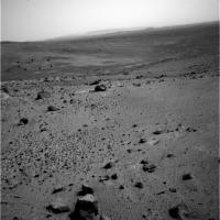
Since we're getting close to getting there, it's time for any of your uninformed speculations out there to be recorded for all posterity...  I posted the following in that thread, but it really belongs here, so I'm reposting it here and inviting discussion. I figure that a lot of us don't bother to read the boards we don't stay actively involved with, so for all of you, this is new. Otherwise, I apologize for the repetitiion! Look at the vertically-exaggerated image posted here. Home Plate seems very obviously, in this stretched image, to be the remnant of an impact crater. There are several impact crater remnants in the inner basin, here. Each seems to have been formed in a surface that was a good many meters higher than the present surface -- those missing several meters have been deflated from this terrain, by some process, leaving the shocked "pedestal" remnants of the deeper cratering forms. Remember, when you make an impact crater, you don't just affect the surface. The disruption caused by the cratering event goes well under the surface, consisting of impact melt (if the impact is energetic enough) and shocked, brecciated rocks. The crater remnants we're seeing on the surface look like the brecciated and shocked rocks that were originally created in a bowl-shaped lining beneath this cluster of impact craters. I can see traces of at least five different craters within the inner basin, here. (The ridge of rock Spirit is passing right now is, in fact, a small crater remnant.) As for Home Plate, it sits within the largest and most well-defined of these crater remnants. Maybe such layers were exhumed in *all* of the craters here, and have since been completely eroded away -- but that doesn't seem right. We have traces of several craters, and in only one of them do we see any trace of this lighter-colored material. I'd have to think that either the impact target composition was different where the Home Plate impact occurred -- which seems a little unlikely when you consider some of these impacts are only a few tens of meters apart -- or that some other substance was deposited in Home Plate crater that wasn't deposited in the other craters. (Or that has been completely deflated from the other craters, if it ever existed there.) So, logic *seems* to point towards post-cratering material deposition accounting for the light-rock ring. Personally, I think it could have been water deposition. Home Plate could have been a puddle that was filled and dried thousands of times (maybe with an internal artesian spring) that resulted in aqueous transport and deposition. Or, it could have just been a good wind trap and it trapped a lot of light-colored dust. Hard to say. I'm not only interested in the light-rock ring's composition, I'm getting very curious about the erosion process that deflated the original surface. Could aeolian erosion have deflated *that* much surface, even over a few billion years? Do we need to postulate aqueous erosion, or even glacial erosion? Maybe the specific composition and erosion patterns we see on the light-rock ring will help us puzzle that out. -the other Doug -------------------- The trouble ain't that there is too many fools, but that the lightning ain't distributed right. -Mark Twain
|
 |
 
|
|
Jan 25 2006, 04:38 PM
Post
#2
|
|
|
Member Group: Members Posts: 236 Joined: 21-June 05 Member No.: 417 |
Eroded core of a volcano
|
|
|
|
|
Jan 25 2006, 04:45 PM
Post
#3
|
|
|
Member Group: Members Posts: 311 Joined: 31-August 05 From: Florida & Texas, USA Member No.: 482 |
QUOTE (dvandorn @ Jan 25 2006, 10:10 AM) So, logic *seems* to point towards post-cratering material deposition accounting for the light-rock ring. Personally, I think it could have been water deposition. Home Plate could have been a puddle that was filled and dried thousands of times (maybe with an internal artesian spring) that resulted in aqueous transport and deposition. Or, it could have just been a good wind trap and it trapped a lot of light-colored dust. Hard to say. -the other Doug  I'd agree that Homeplate most resembles the exumed floor of an impact basin, but there are a few inconsistencies: 1. why is the SE "rim" sheared off in a straight line? 2. why isn't there more craters in Gusev that show homeplate-like features? It seems too enigmatic. 3. Bonneville was an excellent sand trap, but it's floor didn't look like this, so I think the sand-trap theory is not as likely, but maybe a crater floor with a puddle... but again, why would this be the only crater to form evaporites? Thanks for opening the speculation flood gates! |
|
|
|
|
Jan 25 2006, 04:52 PM
Post
#4
|
|
|
Senior Member Group: Members Posts: 3008 Joined: 30-October 04 Member No.: 105 |
Good question, but we won't know for sure until we can thwack Homeplate.
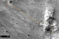
My thoughts are that Homeplate and the several light "layered deposits" are erosional remnants of a widespread unit that has been deflated or eroded. I have a map on this board, adapted from Alan's route map, that ties the Homeplate to the scattered layered unit outcrops. I can't find it on the board right now, but I have it on my home 'puter and will post it later tonight. I think that Homeplate might be the bowl of a paleocrater, but we need to find impact breccia, shattercones, etc first. Put me down for a definite maybe... --Bill -------------------- |
|
|
|
|
Jan 25 2006, 04:53 PM
Post
#5
|
|
|
Solar System Cartographer Group: Members Posts: 10229 Joined: 5-April 05 From: Canada Member No.: 227 |
Very interesting topic - and a good idea to move it here.
It's not so clear to me that HP is a crater remnant. Admittedly it looks a bit like it in the image Doug linked to. But what about all the other light material on the way, especially just before Comanche? In fact, Comanche seemed to be superimposed on bright stuff, stratigraphically higher. Is HP part of a much wider layer? If so, what is it? Just as a working hypothesis I'll throw out this possibility. The hills are a composite of multiple layers of ejecta, volcanic ash from Apollinaris or elsewhere, and maybe wind-deposited material, stacked up over hundreds of millions of years after Gusev formed. They were sculpted by small impacts (Inner Basin, East Basin etc.). A brief flood - more like a mudflow - from Ma'adim Vallis soaked the area, but never really formed a lake. Later the basalts of the actual landing area flooded part of the Gusev floor. Since then small impacts like Castril and Bonneville have scattered ejecta over everything. Deflation acting over 3 Gy has gradually eaten away at the hills, which were never consolidated and deflate faster than the basalt plains. HP would be part of one such layer. I don't know what it is, but let's say for sake of argument it's a layer of fine volcanic ash deposited over an irregular surface within the stack of ejecta etc comprising the hills. Other parts of the same formation are visible around (under) Comanche. It will be altered by exposure to water. Now it's being exhumed by aeolian action in several places. Maybe HP itself is a place where the layer was deposited in an old depression and has been preserved better than elsewhere. Just a guess! To my mind one of the most interesting things about this will be looking for stratigraphic contacts. Can we see where the HP material sits right on top of the underlying stuff? I have a hunch that the NW corner of it exposes a section at least a meter or two high. That would be my first priority. Phil -------------------- ... because the Solar System ain't gonna map itself.
Also to be found posting similar content on https://mastodon.social/@PhilStooke Maps for download (free PDF: https://upload.wikimedia.org/wikipedia/comm...Cartography.pdf NOTE: everything created by me which I post on UMSF is considered to be in the public domain (NOT CC, public domain) |
|
|
|
|
Jan 25 2006, 06:03 PM
Post
#6
|
|
 Member Group: Members Posts: 706 Joined: 3-December 04 From: Boulder, Colorado, USA Member No.: 117 |
QUOTE (Phil Stooke @ Jan 25 2006, 04:53 PM) HP would be part of one such layer. I don't know what it is, but let's say for sake of argument it's a layer of fine volcanic ash deposited over an irregular surface within the stack of ejecta etc comprising the hills. Other parts of the same formation are visible around (under) Comanche. It will be altered by exposure to water. Now it's being exhumed by aeolian action in several places. Maybe HP itself is a place where the layer was deposited in an old depression and has been preserved better than elsewhere. I suspect Phil is exactly right. Homeplate is probably an unusually symmetrical remnant of one of the light-colored layers like the ones we've been traversing on the way down from Husband Hill, maybe preserved because it's at a low point in the undulations that are apparent in the layers throughout the Columbia Hills. I still don't understand all these undulations though- most deposition mechanisms would form fairly horizontal layers initially (draping over existing topography is possible, but usually the deposited stuff just collects in the depressions, and doesn't form a uniformly thick mantle over everything). It's not clear to me how impacts could warp the layers in the broad, coherent way that we see. |
|
|
|
|
Jan 25 2006, 07:26 PM
Post
#7
|
|
|
Member Group: Members Posts: 624 Joined: 10-August 05 Member No.: 460 |
Given the clean lines on the rim, I would go with a snapped off fossilized Sequia - notice the proturding serpentine root structure
 Seriously, I vote for a volcanic origin for this very reason: The serpentine hills surrounding homeplate could be volcanic in nature...either that or the grounds keeper left the hose out and running, and it sunk into the mud. Very curious feature. |
|
|
|
|
Jan 25 2006, 07:33 PM
Post
#8
|
|
|
Newbie Group: Members Posts: 1 Joined: 20-April 05 Member No.: 308 |
Just to throw out an alternate hypothesis, perhaps Home Plate is a megablock excavated by some large impact event. As for composition, it can certainly end up being volcanic ash, but a far more exciting possibility would be lacustrine deposits from the ancient lake in Gusev crater, which is what Spirit was originally sent to find.
|
|
|
|
|
Jan 25 2006, 07:39 PM
Post
#9
|
|
|
Member Group: Members Posts: 236 Joined: 21-June 05 Member No.: 417 |
Could these strange 'sandwich'rocks be an indication of what HP might be? They look like layers of pumice and petrified ash (?)
http://qt.exploratorium.edu/mars/spirit/pa...00P2555L7M1.JPG |
|
|
|
|
Jan 25 2006, 07:40 PM
Post
#10
|
|
|
Senior Member Group: Members Posts: 3008 Joined: 30-October 04 Member No.: 105 |
I wouldn't be suprised if, just as the Homeplate formation is draped over a wide area of the Inner Basin, the unit now typified by Comanche is present as erosional remants overlying that lower Homeplate unit, visible as the "Pitcher's Mound", the hill just south of the Ultreya dunes, and other spots in the Inner Basin. Look at Alan's vertically exaggerated Route Map of the Inner Basin.
--Bill -------------------- |
|
|
|
|
Jan 25 2006, 09:09 PM
Post
#11
|
|
|
XYL Code Genius Group: Members Posts: 138 Joined: 23-November 05 Member No.: 566 |
I think Home Plate is very salty.
|
|
|
|
|
Jan 25 2006, 09:50 PM
Post
#12
|
|
 Member Group: Members Posts: 656 Joined: 20-April 05 From: League City, Texas Member No.: 285 |
Odds are that it is evaporite, with volcanic ash blended-in. However, have we ruled-out water ice with any confidence? That is, has the remote sensing from on top of the hill (and orbit) been sufficient to look for H20 and determine it was absent? If not, the structure and geography might suggest an ice plug above a spring (I believe a spring would be required to maintain an exposure of ice at this latitude). Not likely, but just at the moment I wouldn't rule it out.
|
|
|
|
|
Jan 26 2006, 04:09 AM
Post
#13
|
|||
|
Senior Member Group: Members Posts: 1636 Joined: 9-May 05 From: Lima, Peru Member No.: 385 |
I put my toughts on the following.
The Home Plate is not a good oval or circle in as an impact factor. I am not considering this as an impact origin. On the other hand, the HP has light color surface and it is not only one but there is another similar but smaller and it is located in the North Basin (see the pictures from August 23, 2005)
The other reasoning is that the water from Gusev must not have filled into these holes (North and Inner Basin). I discard that the light color is a product of mixing of condensed water wapor with volcanic ash from atmosphere. Mars might have undergone severe glacial periods due to its high tilt. The most probable hypothesis that I think might be from hot water coming out from subsurface as a spring of warm water or steam caused by some kinetic energy originated by impact meteors around Hills (McCool, Columbia, Husband). Then I think that these plates were formed by the action of spring and not by an impact. Below is the Spirit landing zone and I have circled two blue circles showing the alike light color circles
Rodolfo |
||
|
|
|
||
|
Jan 26 2006, 05:38 AM
Post
#14
|
|
 Senior Member Group: Members Posts: 2228 Joined: 1-December 04 From: Marble Falls, Texas, USA Member No.: 116 |
I have to get in on this crapshoot. Although I have no idea what Home Plate actually is, as far as the rock type, minerals, or actual mode of origin, I do have some hypotheses based on what we have seen so far. It sure would help if someone would leak some spectral information that was likely collected with the mini-TES, or reflectance spectra based on the filtered imagery. (hint)
I think my first speculations on the nature of this area were mentioned here, and here. At this point, I still pretty much hold those views, though I suppose I could expand on them a bit, but it will be mostly be another way of describing what some others have already said. This whole valley seems to be filled with erosional remnants of layered rock units. Some appear as decent-looking mesas, and others are more degraded and less defined. I'm not sure that all of the "remnants" are the same unit as the Home Plate layers. I doubt they are, but they are probably pretty close, stratigraphically. I'll admit that I am not absolutely certain, but what little is left of the more resistant of the layers suggests to me a scenario where the original layers of fill were draped over a pre-existant topography. Alternatively, I can't rule out the possibility that some post-depositional, structural deformation has occurred. I think I see some slight concavity in HP. That could easily be from a draping effect, or the expression of an eroded syncline. While the rocks themselves may have originated from volcanic or impact events elsewhere, I don't see HP as the center of such events, only the place where the clasts settled, and were later eroded. Oh, and before I forget to ask again, will the person who originally proposed the name "Pitcher's Mound" for the curious mesa across from Home Plate please stand up and take a bow? That label has obviously become an icon that all here in the UMSF community have come to know and love. -------------------- ...Tom
I'm not a Space Fan, I'm a Space Exploration Enthusiast. |
|
|
|
|
Jan 26 2006, 06:18 AM
Post
#15
|
|
 Senior Member Group: Members Posts: 1229 Joined: 24-December 05 From: The blue one in between the yellow and red ones. Member No.: 618 |
QUOTE (CosmicRocker @ Jan 25 2006, 07:38 PM) Oh, and before I forget to ask again, will the person who originally proposed the name "Pitcher's Mound" for the curious mesa across from Home Plate please stand up and take a bow? That label has obviously become an icon that all here in the UMSF community have come to know and love. Sir, You will have to speak to the General, Sir! I believe this term originated at oh eight twenty six hundred hours on two zero September, 2005. Sir. The post was number one seven within the subject designated as "Stereo Home Plate!". -------------------- My Grandpa goes to Mars every day and all I get are these lousy T-shirts!
|
|
|
|
|

|
Lo-Fi Version | Time is now: 26th September 2024 - 08:54 AM |
|
RULES AND GUIDELINES Please read the Forum Rules and Guidelines before posting. IMAGE COPYRIGHT |
OPINIONS AND MODERATION Opinions expressed on UnmannedSpaceflight.com are those of the individual posters and do not necessarily reflect the opinions of UnmannedSpaceflight.com or The Planetary Society. The all-volunteer UnmannedSpaceflight.com moderation team is wholly independent of The Planetary Society. The Planetary Society has no influence over decisions made by the UnmannedSpaceflight.com moderators. |
SUPPORT THE FORUM Unmannedspaceflight.com is funded by the Planetary Society. Please consider supporting our work and many other projects by donating to the Society or becoming a member. |
|