Journey to Mt Sharp - Part 1: Site 7 to Waypoint 1, Sol324 [Jul4,'13] to Sol391 [Sep12,'13] |

  |
Journey to Mt Sharp - Part 1: Site 7 to Waypoint 1, Sol324 [Jul4,'13] to Sol391 [Sep12,'13] |
 Aug 12 2013, 09:57 AM Aug 12 2013, 09:57 AM
Post
#273
|
|
 Senior Member  Group: Members Posts: 1619 Joined: 12-February 06 From: Bergerac - FR Member No.: 678 |
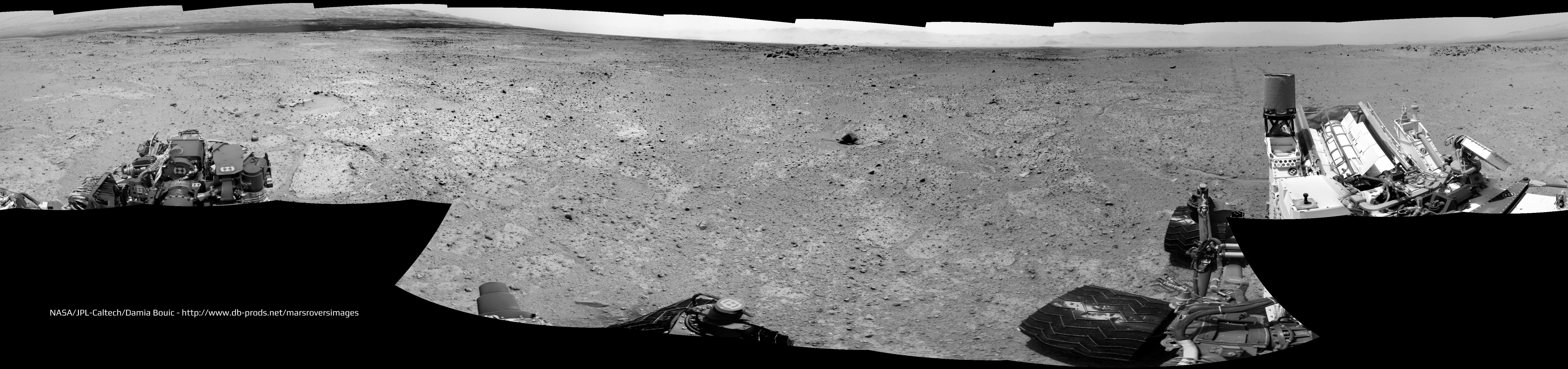
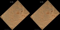
Sol 361 Navcam pan :
-------------------- |
 |
 
|
| Guest_Actionman_* |
Aug 12 2013, 11:47 AM
Post
#274
|
|
Guests |
QUOTE (jmknapp @ Aug 11 2013, 02:44 PM)  A couple more anaglyphs from the current position: The dark dune does indeed look to be in the lowest elevation, I call this one; Acheron.  The opposite bank looks very steep!  
|
|
|
|
|
Aug 12 2013, 12:02 PM
Post
#275
|
|
|
Senior Member Group: Members Posts: 2346 Joined: 7-December 12 Member No.: 6780 |
Sol 360/361 FLB sequence consisting of APXS, MAHLI, APXS (overnight), new location:
 Link to animated gif. |
|
|
|
|
Aug 12 2013, 01:39 PM
Post
#276
|
||
|
Solar System Cartographer Group: Members Posts: 10146 Joined: 5-April 05 From: Canada Member No.: 227 |
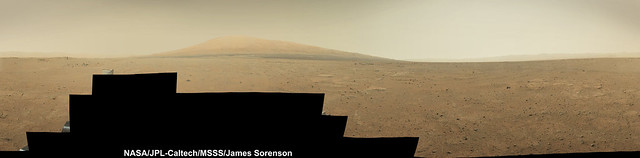
This is Damia's new Navcam pan in circular form. There's a relatively fresh impact crater a few drive distances ahead to the south, a possible target as it might excavate something from under this current surface.
Phil
-------------------- ... because the Solar System ain't gonna map itself.
Also to be found posting similar content on https://mastodon.social/@PhilStooke NOTE: everything created by me which I post on UMSF is considered to be in the public domain (NOT CC, public domain) |
|
|
|
|
|
|
Aug 12 2013, 02:09 PM
Post
#277
|
||
|
Senior Member Group: Members Posts: 2346 Joined: 7-December 12 Member No.: 6780 |
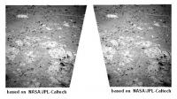
Sol 360 MAHLI stereo as cross-eye
 and as blink gif. Images are rotated 43 degrees to get displacement (almost) horizontal. Edit: A little cross-eye stereo from two Sol 361 Navcam Right B traverse images (not the usual left/right stereo) :
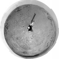
To be complete, a second edit: Sol 360 Mastcam Right APXS mark enhancement (close to the center of the image) : 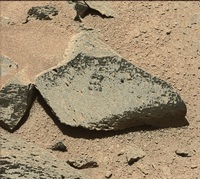 Link to blink gif raw/enhanced. It was obtained by a series of appropriate white balancing, color stretching, channel splitting and combining operations. |
|
|
|
|
|
|
Aug 12 2013, 04:25 PM
Post
#278
|
|
|
Member Group: Members Posts: 507 Joined: 10-September 08 Member No.: 4338 |
QUOTE (Actionman @ Aug 12 2013, 03:47 AM) The dark dune does indeed look to be in the lowest elevation, ... The apparent gulch containing the dark dunes: is that the remains of a paleo-river or stream? Would that be an area of special interest, even if potentially hazardous? |
|
|
|
|
Aug 12 2013, 04:41 PM
Post
#279
|
|
|
Solar System Cartographer Group: Members Posts: 10146 Joined: 5-April 05 From: Canada Member No.: 227 |
The area of greatest interest is in that valley, but of course not in a place where the dunes are covering the good stuff. It's a bit further to the southwest than we can easily see right now, but our view of it will improve over time. I'd say a lake was a better suggestion than a stream at that location. Streams flowed into this area from the north and southwest, but here we are more likely in an area of deposition, possibly in lakes.
Phil -------------------- ... because the Solar System ain't gonna map itself.
Also to be found posting similar content on https://mastodon.social/@PhilStooke NOTE: everything created by me which I post on UMSF is considered to be in the public domain (NOT CC, public domain) |
|
|
|
|
Aug 12 2013, 08:44 PM
Post
#280
|
|
 Member Group: Members Posts: 222 Joined: 7-August 12 From: Garberville, CA Member No.: 6500 |
SOL 361 - Navcam 360 Anaglyph. Some interesting terrain around here for sure. That circular formation a bit to the left of the UHF antenna is a rather curious feature...

-------------------- "We shall not cease from exploration, and the end of all our exploring will be to arrive where we started and know the place for the first time." -T.S. Eliot
|
|
|
|
| Guest_Actionman_* |
Aug 12 2013, 11:35 PM
Post
#281
|
|
Guests |
The dark dune could be stream bed silt made up of heavy grains of a variety of iron oxides complete with ripples.
|
|
|
|
|
Aug 13 2013, 12:07 AM
Post
#282
|
|
|
Solar System Cartographer Group: Members Posts: 10146 Joined: 5-April 05 From: Canada Member No.: 227 |
No. They are dark basaltic sand transported and sculpted by the wind.
Remember the Martian environment is very dry now. The water which flowed in those streams coming off the crater walls flowed long ago, maybe 3 billion years or more. If water ever flows now it will be in tiny amounts in some of the gullies we've seen elsewhere. Ripples could have formed in an ancient streambed, but they would have been eroded away in the intervening billions of years. If we see those things now, only the wind can have formed them. And these features have been observed to move from year to year in HiRISE images. We know they are active right now. Also - if a stream, where did it flow from, and where to? The geography doesn't support it. There's lots of information on Gale crater out there (check the FAQs in the MSL section) - check it out. Phil -------------------- ... because the Solar System ain't gonna map itself.
Also to be found posting similar content on https://mastodon.social/@PhilStooke NOTE: everything created by me which I post on UMSF is considered to be in the public domain (NOT CC, public domain) |
|
|
|
|
Aug 13 2013, 01:44 AM
Post
#283
|
|
|
Senior Member Group: Members Posts: 1043 Joined: 17-February 09 Member No.: 4605 |
Too true. We don't have much of a clue as to how much material was deposited over the existing surface and then eroded, but the inverted channels on the fan and elsewhere indicate that the current surface was beneath the level where those streams flowed. The current topography does not necessarily reflect the topography of that time. The thing that niggles is that the southern crater rim is almost eroded away, unlike the northern rim. One possible (though right out there) explanation given the huge difference in elevation is that the northern rim was actually submerged and thus protected during the high energy aeolian environments of the Noachian and early Hesperian.
|
|
|
|
| Guest_Actionman_* |
Aug 13 2013, 02:17 AM
Post
#284
|
|
Guests |
QUOTE (Gerald @ Aug 12 2013, 09:09 AM) To be complete, a second edit: Sol 360 Mastcam Right APXS mark enhancement (close to the center of the image) : It was obtained by a series of appropriate white balancing, color stretching, channel splitting and combining operations. Now that looks like granite. |
|
|
|
|
Aug 13 2013, 03:16 AM
Post
#285
|
|
 Senior Member Group: Members Posts: 3419 Joined: 9-February 04 From: Minneapolis, MN, USA Member No.: 15 |
QUOTE (Actionman @ Aug 12 2013, 08:17 PM) Now that looks like granite. I'm not sure how likely it would be to find granitic rocks on Mars -- my understanding is that most all terrestrial granites are a product of plate tectonics, formed by the interaction of the water in subducted sea floor materials interacting with the hot crust/mantle interface and enriching the basaltic mantle with the quartz and aluminous feldspathic grains found in granites. The theory I heard was that this melt would be significantly lighter than the basaltic mantle and would push up through cracks in the crust to form a granitic "basement" to the continental landmasses below which the sea floor is being subducted. (Of course, when I try to look up information about this theory, Wikipedia seems to think it's an outdated opinion and not in vogue these days...) Now, if significant granite *were* to be found anywhere on Mars, it would be interesting to speculate on the process of its formation. -the other Doug -------------------- The trouble ain't that there is too many fools, but that the lightning ain't distributed right. -Mark Twain
|
|
|
|
|
Aug 13 2013, 03:51 AM
Post
#286
|
|
 Administrator Group: Admin Posts: 5172 Joined: 4-August 05 From: Pasadena, CA, USA, Earth Member No.: 454 |
No. It is not granite. It is almost certainly a Mars basalt, on which the contrast has been turned up to 11 to make it look bright. Granites happen on Earth because the rocks have been partially melted and recycled and partially melted and recycled a million times. They are refined through huge amounts of geologic processing. Nobody expects to find them on Mars. Maybe Venus (where there are dome volcanoes that could mean silica-rich granite-like melts) but not Mars.
Early in the mission I wrote a blog entry explaining the APXS and ChemCam results on Jake M. The petrologists were super excited that they had found a basalt that was marginally more evolved than the basalts that have been found everywhere else on Mars. It was still basalt. If anybody even finds an andesite, the petrologists will be over the Moon. Granites/rhyolites are really not at all likely. And nobody can identify a rock's specific composition from a Mastcam photo. You need something that can tell you elemental and/or mineralogical makeup: APXS, ChemCam, or Chemin. If it's a dark-colored rock and you call it "basalt," you'll be right most of the time; and if you're saying it's not basalt you'll need analytical instrumental results to back up that extraordinary claim. -------------------- My website - My Patreon - @elakdawalla on Twitter - Please support unmannedspaceflight.com by donating here.
|
|
|
|
|
Aug 13 2013, 04:00 AM
Post
#287
|
|
 Member Group: Members Posts: 691 Joined: 21-December 07 From: Clatskanie, Oregon Member No.: 3988 |
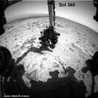
The Finished Sol-352 Full Resolution Panorama.
   |
|
|
|
|

|
Lo-Fi Version | Time is now: 20th April 2024 - 02:43 AM |
|
RULES AND GUIDELINES Please read the Forum Rules and Guidelines before posting. IMAGE COPYRIGHT |
OPINIONS AND MODERATION Opinions expressed on UnmannedSpaceflight.com are those of the individual posters and do not necessarily reflect the opinions of UnmannedSpaceflight.com or The Planetary Society. The all-volunteer UnmannedSpaceflight.com moderation team is wholly independent of The Planetary Society. The Planetary Society has no influence over decisions made by the UnmannedSpaceflight.com moderators. |
SUPPORT THE FORUM Unmannedspaceflight.com is funded by the Planetary Society. Please consider supporting our work and many other projects by donating to the Society or becoming a member. |
|