Jezero Delta Campaign, Sols 414-1000, 21 Apr 2022- 23 Dec 2023 |

  |
Jezero Delta Campaign, Sols 414-1000, 21 Apr 2022- 23 Dec 2023 |
 Feb 4 2023, 02:08 AM Feb 4 2023, 02:08 AM
Post
#616
|
|
|
Senior Member  Group: Members Posts: 1043 Joined: 17-February 09 Member No.: 4605 |
Given the 90 degree cleavage my somewhat wet fingered guess would be a fragment of plagioclase feldspar. A reasonably high probability actually given that the Jezero catchment encompasses part of the highest concentration of plagioclase identified by TES.
|
 |
 
|
|
Feb 4 2023, 08:38 PM
Post
#617
|
|
 Senior Member Group: Members Posts: 1624 Joined: 5-March 05 From: Boulder, CO Member No.: 184 |
-------------------- Steve [ my home page and planetary maps page ]
|
|
|
|
|
Feb 4 2023, 11:16 PM
Post
#618
|
|||
|
Senior Member Group: Members Posts: 1624 Joined: 5-March 05 From: Boulder, CO Member No.: 184 |
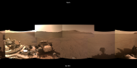
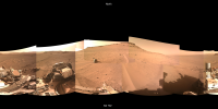
Sol 694 panorama, along with a large version derived from Paul's tiled NavCams and pointing info.
Sol 695 panorama and large version.
We can watch the changing landscape in this extended drive animation from Sol 394 to the present. -------------------- Steve [ my home page and planetary maps page ]
|
||
|
|
|
||
|
Feb 5 2023, 06:50 AM
Post
#619
|
|
 Member Group: Members Posts: 800 Joined: 9-September 17 From: UK Member No.: 8241 |
-------------------- |
|
|
|
|
Feb 5 2023, 06:56 AM
Post
#620
|
|
|
Member Group: Members Posts: 800 Joined: 9-September 17 From: UK Member No.: 8241 |
-------------------- |
|
|
|
|
Feb 5 2023, 10:56 AM
Post
#621
|
|
|
Member Group: Members Posts: 800 Joined: 9-September 17 From: UK Member No.: 8241 |
-------------------- |
|
|
|
|
Feb 6 2023, 07:46 AM
Post
#622
|
|||
|
Solar System Cartographer Group: Members Posts: 10145 Joined: 5-April 05 From: Canada Member No.: 227 |
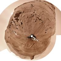
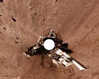
I thought I would experiment with something different for the sol 695 drive. Steve Albers has been making panoramas from Paul's images. The first step in my circular image production is to make a panorama as well, but they are not very aesthetic so I have not been posting them. This time I thought I would experiment with Steve's panorama for sol 695, and this is the result:
It works well, so if Steve will allow it I will use his panoramas again when they are available. It saves me some time (and time is something I don't have enough of). I did do some work to reduce the visibility of image seams - some brightness and colour changes, and a few small geometry adjustments, but it's still quicker than my usual process. And the image is sharper near the horizon. Phil -------------------- ... because the Solar System ain't gonna map itself.
Also to be found posting similar content on https://mastodon.social/@PhilStooke NOTE: everything created by me which I post on UMSF is considered to be in the public domain (NOT CC, public domain) |
||
|
|
|
||
|
Feb 6 2023, 11:25 AM
Post
#623
|
|
|
Member Group: Members Posts: 800 Joined: 9-September 17 From: UK Member No.: 8241 |
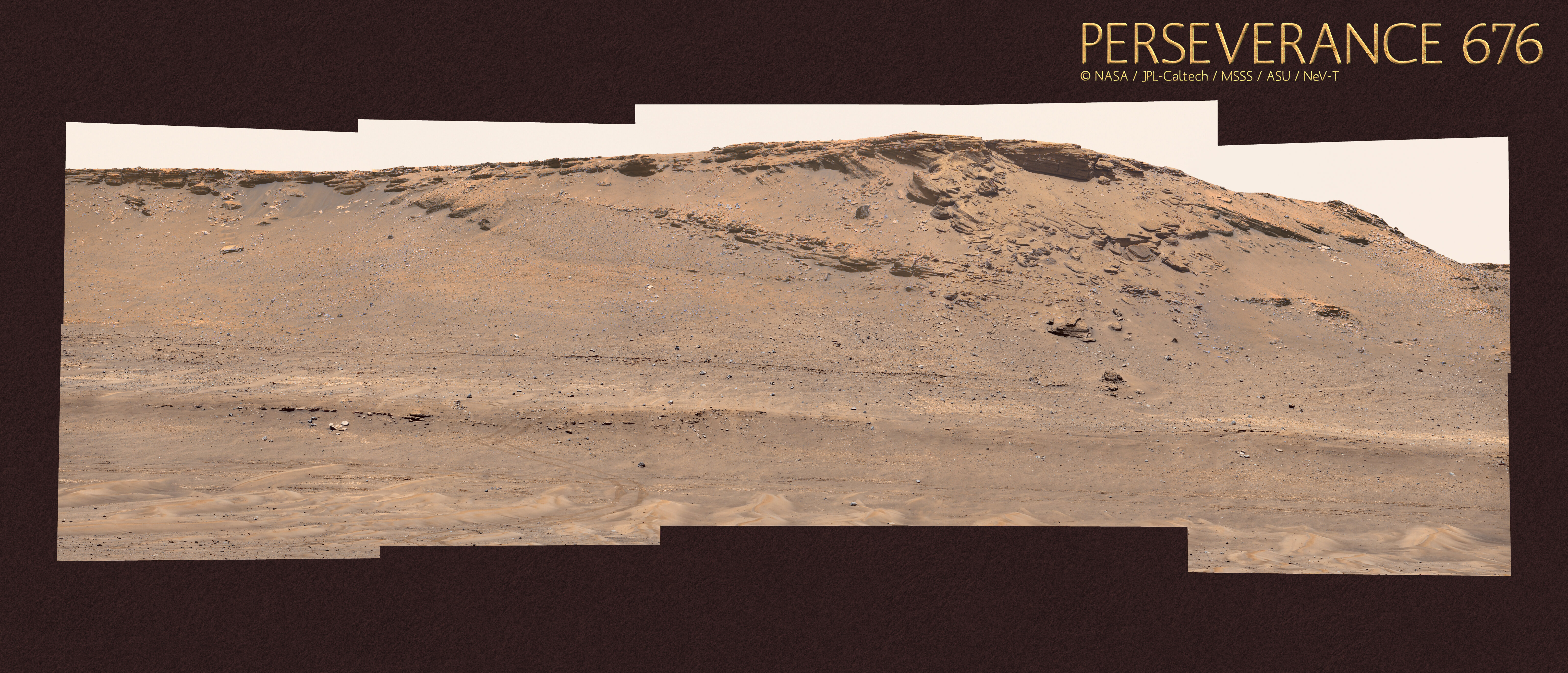
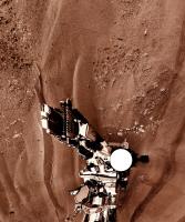
 Gigapan - PERSEVERANCE 693 © NASA/JPL-Caltech/MSSS/ASU/NeV-T Full size Image Download Gigapan Website My Website -------------------- |
|
|
|
|
Feb 7 2023, 06:21 PM
Post
#624
|
||
|
Senior Member Group: Members Posts: 1624 Joined: 5-March 05 From: Boulder, CO Member No.: 184 |
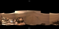
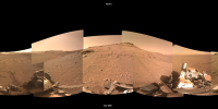
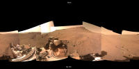
Sol 698 panorama, along with a large version derived from Paul's tiled NavCams and pointing info.
We can watch the changing landscape in this extended drive animation from Sol 394 to the present. -------------------- Steve [ my home page and planetary maps page ]
|
|
|
|
|
|
|
Feb 8 2023, 11:37 PM
Post
#625
|
|||
|
Solar System Cartographer Group: Members Posts: 10145 Joined: 5-April 05 From: Canada Member No.: 227 |
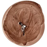
This is Steve's panorama (based on Paul's images) in circular form. Some seams tweaked a bit and the contrast enhanced. The very steep slope in front of the rover makes for a distorted view.
Phil
-------------------- ... because the Solar System ain't gonna map itself.
Also to be found posting similar content on https://mastodon.social/@PhilStooke NOTE: everything created by me which I post on UMSF is considered to be in the public domain (NOT CC, public domain) |
||
|
|
|
||
|
Feb 9 2023, 08:32 PM
Post
#626
|
|
|
Member Group: Members Posts: 800 Joined: 9-September 17 From: UK Member No.: 8241 |
-------------------- |
|
|
|
|
Feb 9 2023, 10:48 PM
Post
#627
|
|
|
Senior Member Group: Members Posts: 1043 Joined: 17-February 09 Member No.: 4605 |
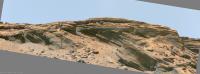
Is that tilt on the left of Neville's image gravity driven collapse or erosion followed by a later deposition from right to left?
|
|
|
|
|
Feb 11 2023, 12:03 PM
Post
#628
|
|||
 Member Group: Members Posts: 661 Joined: 9-May 21 From: Germany Member No.: 9017 |
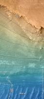
The actual tilt of Mastcam-Z around the optical axis with respect to the horizon on the left side of Neville's panorama was about 4° clockwise,
while this part of the panorama is slightly tilted about 2° counterclockwise. Therefore, this part should be rotated 6° clockwise. Additionally, there is a perspectivic effect. The top of the cliff is 60 m higher than the rover position. The distance to the rover is about 180 m. The cliff edge is on its left side farther away from the rover, which reduces the apparent height there due to perspective and results in an additional apparent tilt of the cliff edge to the left by a few degrees. Therefore, the cliff will look more like the image below, where the apparent tilt is reduced, and only a slight apparent dip of the layers above the erosional unconformity to the left remains. The elevation map shows that the top of the cliff is quite flat within a few meters.
|
||
|
|
|
||
|
Feb 11 2023, 08:21 PM
Post
#629
|
|||
|
Senior Member Group: Members Posts: 1624 Joined: 5-March 05 From: Boulder, CO Member No.: 184 |
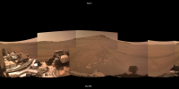
Sol 700 panorama, along with a large version derived from Paul's tiled NavCams and pointing info.
Sol 702 panorama, along with a large version.
We can watch the changing landscape in this extended drive animation from Sol 394 to the present. -------------------- Steve [ my home page and planetary maps page ]
|
||
|
|
|
||
|
Feb 11 2023, 10:27 PM
Post
#630
|
|
|
Senior Member Group: Members Posts: 1043 Joined: 17-February 09 Member No.: 4605 |
Thanks Tau. I hadn't considered panorama tilt and thought the lower ridge provided a reasonable horizontal reference. But even with that correction I still see a rising gradient in the topset to foreset rollover points, evident in localised segments to preclude perspective errors. For example under the round basaltic boulder in the centre of your image. Probably another correction lurking but there is evidence of faulting with potential for localised tilting due to compression.
|
|
|
|
|

|
Lo-Fi Version | Time is now: 16th April 2024 - 06:21 AM |
|
RULES AND GUIDELINES Please read the Forum Rules and Guidelines before posting. IMAGE COPYRIGHT |
OPINIONS AND MODERATION Opinions expressed on UnmannedSpaceflight.com are those of the individual posters and do not necessarily reflect the opinions of UnmannedSpaceflight.com or The Planetary Society. The all-volunteer UnmannedSpaceflight.com moderation team is wholly independent of The Planetary Society. The Planetary Society has no influence over decisions made by the UnmannedSpaceflight.com moderators. |
SUPPORT THE FORUM Unmannedspaceflight.com is funded by the Planetary Society. Please consider supporting our work and many other projects by donating to the Society or becoming a member. |
|