Spirit route on Earth, How Ive followed Spirit since the begining |

Spirit route on Earth, How Ive followed Spirit since the begining |
 Apr 11 2006, 06:12 PM Apr 11 2006, 06:12 PM
Post
#1
|
||||
|
Senior Member  Group: Members Posts: 2920 Joined: 14-February 06 From: Very close to the Pyrénées Mountains (France) Member No.: 682 |
I can read here how people are intimely associated with Spirit and Oppy exploration. Some of us dream about them, dream that they are on Mars with them, some say the importance of following them each day or even each weel turn they ride.
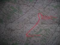
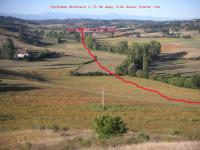
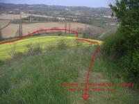
I was lucky enough myself to be in Pasadena with the Planetary Society for Spirit landing. It was such a event! Now, that we've all seen those wonderfully-exceptional maps from Phil, that give more broad view and feeling about what Spirit has accomplished so far, I want to share with you how I've followed Spirit progress myself by just looking at the scenary in front of where I live. I'm (also) lucky enough to live in the country, South west of France, on the top of a hill some +60 meters above the plain, with Pyrénées mountains lying about 70 km in the back-ground. I guess, you've already understood what Im going to show you. You'll find here 3 pictures. One is the general context using an IGN map that show Spirit track from "landing site to my house", the second one is a real picture that show were Spirit has landed, then her weel track up to the base of the hill, and finaly the third one show the final approch to Husband Hill summit were I live. This is for REAL! I've realy mentaly imagined this all the way from landing to the Summit and Phil's map decided me to draw the path on the map (ok, it's very very rought). I realise that each of us need to have some spatial references to figure out how it is on Mars and, for exemple, putting a Rover on a pictures near HP is a real need to figure out the scale. As you can see the Mountains/Gusev crater rim lay some 70 km away. Even if you know that the horizon on Mars is closer than on Earth, it still give you a good spatial reference. I cannot show you the descent from Husband Hill to Home Plate because of a forest on the other side of my house, but still, I can imagine were Spirit is by now. So, Tesheiner and All, if you need help, just ask : I can make a "ground trust" if needed! Im going now to put the real path the best I can on my map and try to follow it from landing to summit. My idea is to respect the scale of time by travelling in, say, 4 hours, that will be represent the 620 sols it realy took Spirit to do it. All UMSFers are very welcomed to come to my place and have a try. I also hope Im not the only one to had such an idea and I also hope you can do it from where you live. Enjoy the ride ! Climber
-------------------- |
|||
 |
 
|
|||
 |
| Guest_Richard Trigaux_* |
Apr 11 2006, 08:38 PM
Post
#2
|
|
Guests |
Héhé le coin des français. Lavaur...
Nice Mars dream... To be noted that, from this distance, the Pyrenees mountains can be easily seen as soon as the weather is fair. That gives an idea of the transparency of martian air, where Gussev wall is not alway visible. |
|
|
|
 climber Spirit route on Earth Apr 11 2006, 06:12 PM
 climber QUOTE (Richard Trigaux @ Apr 11 2006, 10... Apr 11 2006, 09:45 PM helvick QUOTE (climber @ Apr 11 2006, 09:45 PM) I... Apr 11 2006, 10:06 PM AndyG Your map has a place called MOLAS on it: so there ... Apr 12 2006, 08:20 AM climber QUOTE (AndyG @ Apr 12 2006, 10:20 AM) You... Apr 12 2006, 08:49 AM
 |

|
Lo-Fi Version | Time is now: 26th April 2024 - 07:21 PM |
|
RULES AND GUIDELINES Please read the Forum Rules and Guidelines before posting. IMAGE COPYRIGHT |
OPINIONS AND MODERATION Opinions expressed on UnmannedSpaceflight.com are those of the individual posters and do not necessarily reflect the opinions of UnmannedSpaceflight.com or The Planetary Society. The all-volunteer UnmannedSpaceflight.com moderation team is wholly independent of The Planetary Society. The Planetary Society has no influence over decisions made by the UnmannedSpaceflight.com moderators. |
SUPPORT THE FORUM Unmannedspaceflight.com is funded by the Planetary Society. Please consider supporting our work and many other projects by donating to the Society or becoming a member. |
|