Printable Version of Topic
Click here to view this topic in its original format
Unmanned Spaceflight.com _ Opportunity _ Bay of Toil
Posted by: Tesheiner Jan 12 2007, 08:46 AM
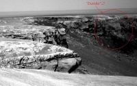
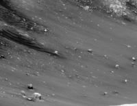
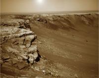
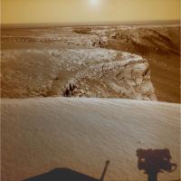
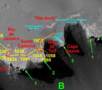
Bay of Toil is on sight after sol 1055 drive.
http://nasa.exploratorium.edu/mars/opportunity/navcam/2007-01-12/1N221847687EFF78AZP0645L0M1.JPG
|
|
Posted by: Stu Jan 12 2007, 09:33 AM
Now THIS looks like an interesting spot for a picnic... 
Leaving aside the wisdom of poking Fate in the eye with a big sharp stick by naming a crumbling crater rim bay "The Bay of Toil" ...  ... here's a quick feature nickname suggestion that kinda jumped out at me...
|
Posted by: djellison Jan 12 2007, 11:56 AM
What might make a very interesting target for a weekend (next weekend perhaps ) is what I've started calling the 'dock' of the Bay of Toil - just north of the bay a sort of 'echo' of the rim set back 10m or so. A few 10's of CM's of material.
Doug
Posted by: Tesheiner Jan 12 2007, 12:05 PM
"The dock", I like this name.
I'm curious about that outcrop since two weeks ago. I was wondering if those are remnants of an upper rock layer or perhaps Cape Desire is "cracking" at that point and becoming a sort of "Soup Dragon" in a couple of hundred million years.
Posted by: Stu Jan 12 2007, 06:49 PM
Wow... 
|
Posted by: climber Jan 12 2007, 06:58 PM

A Bay, The dock, a week-end, a Picnic ?
Can we just Sit on the Dock of The Bay for the week-end?
Sitting On The Dock Of The Bay
by Otis Redding/Steve Cropper... and some changes by Climber...

Sitting in the morning sun
I'll sitting till the evening comes
Watching Oppy roll in
Then I watch her roll away again, yeah.
Sitting on the dock of the bay
Watching the time roll away
Oh, sitting on the dock of the bay
Wasting time, ah ha ha
I left my home in California
And headed for Toil Bay
Coz I have nothing to live for
And look's like nothing will come my way
So, I'm sitting on the dock of the bay
Watching the tide go away
I'm sitting on the dock of the bay
Wasting time
Look's like nothing's gonna change
Everything still remains the same
I can do what people tell me to do
So, I guess I'll remains the same
Sitting here west in East born
And this loneliness won't leave me alone
It's 200 Millions miles I roll
Just to make this dock my home
Sitting on the dock of the bay
Watch the tide go away, ooohh ooohh
Sitting on the dock of the bay
Wasting time
Posted by: jvandriel Jan 12 2007, 09:05 PM
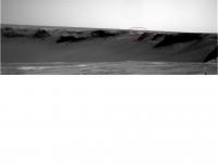
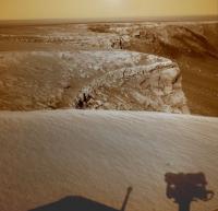
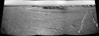
Here is the Pancam L2 view of the Bay of Toil.
Taken on Sol 1055.
jvandriel
|
Posted by: Marz Jan 12 2007, 09:17 PM
Leaving aside the wisdom of poking Fate in the eye with a big sharp stick by naming a crumbling crater rim bay "The Bay of Toil" ...
... here's a quick feature nickname suggestion that kinda jumped out at me...Stu, your posts are always such a joy to read! It looks like a great spot to picnic is the small escarpment of rock north of the Bay of Toil. Could it be a top layer of rock exposed by slumping, and therefore relatively unaltered and easily approached?
Posted by: ElkGroveDan Jan 12 2007, 09:22 PM
Climber you are going to make Stu jealous.
Posted by: Stu Jan 12 2007, 09:53 PM
Jealous? Hmmm, let's see... my prattling "stuff" vs Otis Reading's lyrics... only one winner there I think!
Posted by: Stu Jan 12 2007, 10:23 PM
Like I said, nice place for a picnic...
|
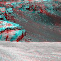
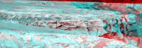
Posted by: fredk Jan 12 2007, 10:51 PM
Great new view today!
The slopes of Victoria are sure messy inside the N-NE rim. Here's a crop from the latest pancams showing more rolling boulder trails, and the corresponding region from a hirise image:
|

|
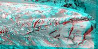
Posted by: alan Jan 12 2007, 11:24 PM
There are a couple of streaks that appear to originate from a 'hole' in a large chunk of ejecta.
|
Posted by: Bob Shaw Jan 12 2007, 11:43 PM
Alan:
I don't see that, I see simply a dustfall beneath an overhang - look to the right and there are many similar overhangs. It's just a series of slightly less eroded lumps.
Bob Shaw
Posted by: MarkL Jan 13 2007, 02:17 AM
Thanks for that comparison fredk. The chevron dunes (very dark in your top image) are interesting. I did not realize they would be on such strongly sloping ground. The material on the surface of these dunes seems to be the same stuff that has blown out of the crater into the dark plumes to the north and nne. (Some say underlying material that's been scraped off, I know)
Posted by: CosmicRocker Jan 13 2007, 07:52 AM
Hehe, MarklL. It will be interesting to pass one of the dark streaks and hopefully see what the story is. For some of us, the removal of the ubiquitous bright dust seems to be the simplest explanation, but I will concede that the opposite has been observed. An interesting Martian location is El Dorado, on the other side of the planet, where dark, olivine-rich sediment has accumulated and later has been covered by the light dust...only to be exposed as dark again by local wind events.
Climber! I can't believe that I missed that association of words. I guess it took Doug to name the outcrop behind B3 as the dock. "Sitting on the dock of the bay..." That's so appropriate.
Posted by: MarsIsImportant Jan 13 2007, 07:22 PM
|
|
That dark spot appearing to be a hole (the one you labeled as such) is really part of a crack across that particular rock. The streaks below, however, do appear to originate with it. We need a much closer look to establish a good interpretation of it. I hope we can do so without endangering the rover.
I cannot help but think of the water flow streaks spotted by MGS on other crater slopes. Such an interpretation is premature, but I just cannot help thinking about it.
Posted by: climber Jan 13 2007, 08:42 PM
Thanks Cosmic...and with your permission Asto,
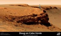
Here is the "Doug of the Bay"

|
Posted by: djellison Jan 13 2007, 09:09 PM
Wahghg
I'm sat here wearing jeans and a shirt, looking at me in the same jeans and shirt, looking at Mars.
Wierd.
Doug
Posted by: marsbug Jan 13 2007, 09:35 PM
While you're there do you think you could drop by home plate and give spirits solar panels a wipe?
Posted by: climber Jan 14 2007, 05:57 AM
I'm sat here wearing jeans and a shirt, looking at me in the same jeans and shirt, looking at Mars.
Wierd.
Doug
You may want to visit there : http://www.unmannedspaceflight.com/index.php?showtopic=3691&hl=
They've got nice T-shirt and other stuff...
Posted by: CosmicRocker Jan 14 2007, 08:54 AM
Nice one, climber. Hehe, poor Doug, standing there dessicated and frozen in-place, trying to snap a pic of Cape Saint Mary to send back to the forum. Talk about dedication...
Posted by: kenny Jan 14 2007, 10:25 AM
Here is the "Doug of the Bay"
|
|
That is brilliant ! Makes FredK look like a mere shadow..... Kenny
Posted by: Astro0 Jan 14 2007, 10:12 PM
It has been such a long time since a I last posted a message and even longer since I have done any SFX images of the Rovers or UMSF members on Mars.
We must be nearing the time for another BBQ. A nice beach (annulus) by a Bay somewhere or on an appropriate Cape perhaps?
Don't go crazy yet UMSF'ers. I think that an announcement in the Community Chat thread will appear soon.
Let me take a look around for a good location first.
Cheers
Astro0
Posted by: climber Jan 15 2007, 01:00 AM
We must be nearing the time for another BBQ. A nice beach (annulus) by a Bay somewhere or on an appropriate Cape perhaps?
Don't go crazy yet UMSF'ers. I think that an announcement in the Community Chat thread will appear soon.
Let me take a look around for a good location first.
Cheers
Astro0
Good to hear about you again AstroO, may be my post of your work kinda wake you up
What about a Sitting on the duck of the Bay as the next one?
Posted by: Astro0 Jan 15 2007, 03:29 AM
Climber said: "...What about a Sitting on the duck of the Bay as the next one?"
OK. I couldn't let the "...duck of the Bay" typo-quote go by...there was no resisting the image it conjured up in my warped little mind.

|
Enjoy
Astro0
Posted by: Tesheiner Jan 15 2007, 11:45 AM
Fresh navcams from sol 1058 at the exploratorium: http://nasa.exploratorium.edu/mars/opportunity/navcam/2007-01-15/
|
Posted by: edstrick Jan 15 2007, 11:55 AM
What we need is a Burroughsian Green Martian, 4 arms and all, standing on the promontory... The riding-thoat and red martian slave girl is optional.
Posted by: Stu Jan 15 2007, 01:09 PM
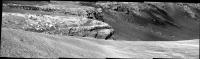
|
Loving this view as it opens up...
Posted by: Airbag Jan 15 2007, 04:18 PM
|
|
That big layered rock at the bottom of the nearby cliff looks accessible to the IDD as the ground below it is not sloping as much as just upslope of it. Certainly no more "roll" slope there than Opportunity already encountered in Endurance crater. Of course, Opportunity would have to get there via some other bay I think and then climb back up to this point. All speculation of course.
Airbag.
PS Doug - you need buy some more clothes
Posted by: MarsIsImportant Jan 15 2007, 04:55 PM
It looks like we possibly found a way OUT of Victory! Take a look and tell me what you think?
|
Posted by: diane Jan 15 2007, 07:10 PM
If we go in through one bay and plan to come out through another, what's the sanity level for navigating around the base of the capes? Considering slope, sand, rock hazards, and so forth.
Posted by: jvandriel Jan 15 2007, 09:11 PM
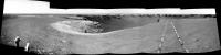
Here is the complete 360 degree panoramic view from Sol 1058.
Taken with the L0 Navcam.
jvandriel
|
|
Posted by: climber Jan 15 2007, 11:24 PM
The choice of the place to enter the crater could be dictated by what you point out here BUT anylising a fallen "rock" will only benefit if you know for sure where it come from. This is hard from where we are so, the option will be to get it anyway so you'll have more infos of where the rock come from by comparing the veiw from the outside with the view from the inside. Now, I wonder of the interest of anylising felt rock because you must have the same info on the way down throught a bay. Benefict could may be to compare the same layer within a Bay and within a Cape...
Posted by: Bob Shaw Jan 15 2007, 11:57 PM
The benefit of rocks in the scree slope below the bluffs is that they are right in front of you, instead of halfway up a vertical wall. You can RAT the dust off, and get a good, long look...
Bob Shaw
Posted by: climber Jan 16 2007, 12:32 AM
Bob Shaw
I agree on this Bob, I just says that if you don't know exactely where they come from, interest is less.
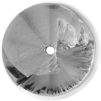
Posted by: Phil Stooke Jan 16 2007, 01:17 AM
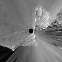
Here is jvandriel's 1058 pan in polar form.
Replying to Diane - we have to go in, but I'm not sure if there is a sanity level for driving round one of the capes!
And regarding scree - outcrops are better than scree because you know where a sample came from - as was said - but on the other hand the multispectral and miniTES can help resolve those issues as well.
Phil
|
Posted by: Airbag Jan 16 2007, 03:05 AM
No, that is not the rock I was refering to. I was refering to one of the larger pieces that make up the cliff itself; one of the presumed aeolian deposit ones. Its origin is quite clear - it is holding up the cliff and has not gone anywhere (yet).
You can see the slope is markedly less right in front of that one; that was my point. All the other "lower cliff" units we have seen so far have had steep slopes next to them.
Airbag
Posted by: mhoward Jan 16 2007, 03:45 AM
Sol 1058
http://flickr.com/photos/marscat/358965910/
Posted by: CosmicRocker Jan 16 2007, 06:19 AM
Thanks for the updates. Some of us were eagerly awaiting them.
MarsIsImportant: Regarding the exit ramp, I think I can see it, as long as that is also the entrance ramp. Like others, I would still be concerned about negotiating any of the major capes adjacent to it. Still, It does appear to be a place entry and exit might be possible.
Posted by: ronatu Jan 16 2007, 04:46 PM
And why is that?
Posted by: Tesheiner Jan 16 2007, 05:38 PM
Few activities (if any) tosol at VC, isn't it? 
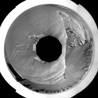
Posted by: dilo Jan 16 2007, 09:37 PM
Thanks, Michael. I know Phil already produced the polar projection, here I add also vertical one (2.5cm/pixel):
|
|
Posted by: Astro0 Jan 17 2007, 12:37 AM
I really love those polar projections from Dilo and others.
Here's my take on it.
"Opportunity on a Fractured World"
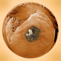
|
Enjoy
Astro0
PS: The rover image came from another UMSF'ers rendering. Sorry I can't remember who.
Posted by: Tesheiner Jan 17 2007, 07:19 AM
These are the planned sequences for sol 1060 and 1061:
- Color/stereo (L257R2) mosaic of Cape Desire
- Drive to a new position
- 180º navcam mosaic centered at 45º
Posted by: Tesheiner Jan 17 2007, 10:54 AM
...
- Drive to a new position
- 180º navcam mosaic centered at 45º
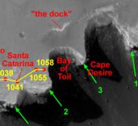
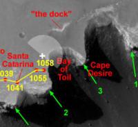
To which point in this area (see below) would you drive and then take a picture centered at 45º (North is 0º)?
|
Hint: It remindes me of a song...
Posted by: djellison Jan 17 2007, 11:42 AM
Due north of current position - imaging toward the dock and the edge of the bay.
|
Posted by: Tesheiner Jan 17 2007, 01:46 PM
Bingo!
That was my guess. However, I have to say that there is another "point with an interesting feature at 45º"; if they drive due south towards the tip of the current cape (*), Cape Desire would be centered right at that angle.
(*) BTW, I can't find any official name to the cape we are currently located (B1-B2).
Posted by: Nix Jan 17 2007, 01:58 PM
I think it was from Vikingmars(ODG). Nice view!
Nico
Posted by: Stu Jan 17 2007, 02:35 PM
Lovely layers...
|
Posted by: Tesheiner Jan 17 2007, 02:53 PM
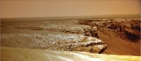
Nice view, indeed. I'm wondering if they plan to drive to the *tip* of Cape Desire.
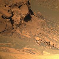
This is a 2x2 pancam mosaic of Cape Desire (L2 channel only, half-res):
|
Two pointings, probably covering the left part of the cape, are still missing.
Posted by: Stu Jan 17 2007, 04:05 PM
Epic rock at the base here...
|
Posted by: Tesheiner Jan 17 2007, 08:58 PM
FWIW, the plan for sol 1061 includes a similar pancam mosaic (6 pointings, L257R2) as this one taken on sol 1060. Then, driving again.
Color stitchers and anaglyph wizards, prepare your tools. 
Posted by: jamescanvin Jan 17 2007, 11:09 PM
Here is what we have so far:
http://www.physics.usyd.edu.au/~jcanvin/mer/index.html#B1060
James
Posted by: OWW Jan 17 2007, 11:10 PM
Color stitchers and anaglyph wizards, prepare your tools.
Looks like L2 only to me...
Sol Seq.Ver ETH ESF EDN EFF ERP Tot Description
----- -------- --- --- --- --- --- ---- -----------
01061 p1151.04 2 0 0 2 0 4 front_hazcam_idd_unstow_doc
01061 p1154.01 2 0 0 2 0 4 front_hazcam_idd_unstow_doc
01061 p1201.07 2 0 0 2 0 4 front_haz_penultimate_1bpp_pri17
01061 p1212.09 2 0 0 2 0 4 front_haz_ultimate_2_bpp_pri15
01061 p1301.06 2 0 0 2 0 4 rear_haz_penultimate_1bpp_pri17
01061 p1311.07 2 0 0 2 0 4 rear_haz_ultimate_1_bpp_crit15
01061 p1585.00 4 0 4 0 0 8 navcam_cloud_4x1_dwnsmp_RVRAz_calstart
01061 p1962.02 10 0 0 10 0 20 navcam_5x1_az_45_3_bpp
01061 p2137.06 1 1 0 0 1 3 pancam_cal_targ_L2
01061 p2351.09 6 0 0 6 1 13 pancam_cape_desire_longbaseline_6pos_L2
01061 p2352.09 8 0 0 8 2 18 pancam_drive_dir_4cx1r_L2R2
01061 p2600.10 2 2 0 0 2 6 pancam_tau
01061 p2633.01 4 2 0 0 2 8 pancam_late_tau_L58R48
01061 Total 47 5 4 36 8 100
Posted by: jamescanvin Jan 17 2007, 11:30 PM
Yeah, which is annoying as the second mosaic is the right eye of the long baseline and L5&7 are needed for a colour anaglyph to be possible. 'L2 only' should be on the left, JB!
James
Posted by: Tesheiner Jan 18 2007, 08:37 AM
Yup. I stand corrected.
Posted by: alan Jan 18 2007, 01:26 PM
James
Couldn't it be done anyway if you viewed the result with the glasses reversed?
Posted by: Tesheiner Jan 18 2007, 02:13 PM
Meanwhile, Oppy moved due north (11m) on sol 1061.

... as expected. 
Navcam pics: http://nasa.exploratorium.edu/mars/opportunity/navcam/2007-01-18/
Posted by: climber Jan 18 2007, 02:26 PM
... as expected.
Navcam pics: http://nasa.exploratorium.edu/mars/opportunity/navcam/2007-01-18/
Would ne nice to test the new software and try to get to the Dock for the week-end
. It seams too far actualy. Did you note this darker ("wet") part in front of us?
Posted by: Tesheiner Jan 18 2007, 02:55 PM
> Would ne nice to test the new software and try to get to the Dock for the week-end.
That was exactly what I thought while waiting for the "drive-direction" pancam images. It would be a 30-40m drive, perhaps too much to be exactly at a nice rock in a single drive for IDD work except if using "go & touch".
But it seems to be out of the plans. This is tosol pancam mosaic; the focus is on Cape Desire, meaning that they are planning to drive on that direction tomorrow sol:
|
BTW, the panorama is a blast! What a view!
> Did you note this darker ("wet") part in front of us?
Yup. It might be dark sand accumulated there in a similar fashion as Eldorado.
Posted by: Ant103 Jan 18 2007, 04:49 PM
Very impressive images there. You're very nice
This my own version of Cape Desire :
http://www.astrosurf.com/merimages/Images_opportunity-2007.html#Sol1060
I can't waiting anymore for the complete imagery set...
Posted by: Stu Jan 18 2007, 06:14 PM
Looking forward to seeing all your true-colour versions of this...
|
This is "Stu-colour"
Posted by: jvandriel Jan 18 2007, 08:34 PM
Stu,
how is it possible ?
Looking in the direction of the sun and see the shadow
of the cam in front of you.
jvandriel
Posted by: jamescanvin Jan 18 2007, 08:49 PM
I did try this once (for a normal anaglyph as most of the blue/green filters are on the left pancam) but for some reason the result wasn't very satisfactory. Maybe I'll have another go with this.
Posted by: Stu Jan 18 2007, 09:22 PM
how is it possible ?
Looking in the direction of the sun and see the shadow
of the cam in front of you.
jvandriel
sigh... well, obviously the Sun is at the top there, and the sunlight is reflecting off Beacon behind Oppy, casting its shadow onto the ground...
(Can't believe I missed that... stoopid stoopid stoopid!!!
blame it on a ten hr shift at work...! )Better?
|
Posted by: jvandriel Jan 18 2007, 09:43 PM
Very nice Stu.
jvandriel
Enjoy your work.
Posted by: jamescanvin Jan 18 2007, 11:25 PM
I see now that I was getting confused. I was thinking the about the 1058 and 1060 positions as being the long baseline positions not 1060/1, so colour should be possible with the glasses the right way around. Greyscale for now though...
The baseline is very long, it works well for C1/2 (Hoy) area:
|
But takes quite a bit of distortion to get Cape Desire viewable:
|
James
Posted by: Greg Hullender Jan 19 2007, 04:53 AM
I keep wanting to use some of these beautiful Victoria pics as my Windows Desktop, but I never see anything that's 1600x1200. Are the actual Rover images smaller than that?
--Greg
Posted by: jamescanvin Jan 19 2007, 05:19 AM
Well all the raw images are 1024x1024 but the pans can be huge. For example my version of the Cape Verde pan (the biggest at Victoria so far) is 17039x3000. I'm sure you could resize and crop a whole load of stunning 1600x1200 images out of the mosaics produced so far.
Posted by: CosmicRocker Jan 19 2007, 06:11 AM
That one popped right into view for me, and it was amazing. I compared it side-by-side with the standard short baseline stereo. The vertical exaggeration (for lack of a better term), really added a tactile dimension to that outcrop. I felt as if I could reach in and gauge the depth of erosion between the laminations with my fingernails, or reach into a crevice, feeling for a loose fossil.Thanks.
Posted by: jamescanvin Jan 19 2007, 06:24 AM
That one popped right into view for me, and it was amazing.I probably should have been clearer. What I meant was *I* had to distort the images quite a bit to make a working anaglyph, removing the need for all of you lot to distort your minds too much.
Glad you enjoyed it.
James
Posted by: Tesheiner Jan 19 2007, 09:53 AM
Now I'm confused.
Wasn't the images for the long baseline those from the positions as of sols 1058 and 1060? Perhaps the confusion is because they were actually taken on sols 1060 and 1061 but *before* driving?
-----------
On a different topic, tosol activities (1062) seems to be devoted to pancam imaging only. I won't expect another move until sunday/monday (sols 1064/1065).
Posted by: Floyd Jan 19 2007, 06:00 PM
No data down from Opportunity today?
Posted by: Tesheiner Jan 19 2007, 08:44 PM
Can't find any at the exploratorium or the pancam web.
Anyway, it's not the first time. Don't panic.
Posted by: jamescanvin Jan 20 2007, 12:18 AM
Wasn't the images for the long baseline those from the positions as of sols 1058 and 1060? Perhaps the confusion is because they were actually taken on sols 1060 and 1061 but *before* driving?
Ah sorry about that, it seems I was even more confused than I realized! I assumed that the images that came down were from the long baseline sequence - and they are clearly from after the drive. But those are in fact the "drive direction" images (I hope they don't!). Still, they made for a good *very* long baseline image.
James
Posted by: fredk Jan 20 2007, 12:37 AM
From the http://marsrovers.jpl.nasa.gov/mission/status_opportunityAll.html#sol1057
How cool can it get?!
Also two new names: Cabo Anonimo = Cape B2, and Guam = Dock of the bay.
Posted by: Stu Jan 20 2007, 01:08 AM
Hmmmm...  I doubt the comet will look very impressive from Mars, what with a) Mars being a lot farther away from it than Earth, and the comet appearing much closer to the Sun in the sky as seen from Mars than from Earth, but hey, you never know...
Posted by: jamescanvin Jan 20 2007, 01:29 AM
Maybe it won't *look* very impressive, but the *idea* of seeing a comet at all from the surface of Mars is VERY impressive (to me anyway).

Posted by: jamescanvin Jan 20 2007, 01:39 AM
1064 it is.
Posted by: CosmicRocker Jan 20 2007, 06:24 AM
How cool can it get?!
Also two new names: Cabo Anonimo = Cape B2, and Guam = Dock of the bay.
I simply find it amazing that our robotic proxies on another planet, originally designed to be remotely controlled geologists have learned new skills, and are now astronomers as well. Surely it's not just not cosmetic. Having a longer baseline for astronomic observations should add to our knowledge of the orbits, or at least help to better calibrate our instruments.As for Guam, it just doesn't have the same ring as "sitting on the dock of the bay." I think I'll always remember it with our name.
Posted by: nprev Jan 20 2007, 07:03 AM
I seem to recall an old painting that showed a major comet from the surface of Mars (Bonestell, Ludek Pesek, or William Hartmann?)...selfishly hoping here that the pics of McNaught include some Martian horizon, but I have no idea what the viewing geometry will be.
Posted by: Stu Jan 20 2007, 08:26 AM
ABSOLUTELY!
Couldn't agree more. I was just commenting on the practicalities, that's all. I had a go simulating it on STARRY NIGHT and to Oppy the comet will be very close to the Sun in a very bright dawn sky...

|
but the comet doesn't actually "pop out" until you turn the sky colour off. I suspect it might not be visible, but with that long tail who knows... No-one would love to see an image of a comet blazing in Mars' dusk sky more than me.
Posted by: Stu Jan 20 2007, 08:49 AM
This one?
http://www.novaspace.com/CARDS/PIX/comet_mars.jpg
Posted by: Bob Shaw Jan 20 2007, 01:56 PM
I doubt the comet will look very impressive from Mars, what with a) Mars being a lot farther away from it than Earth, and the comet appearing much closer to the Sun in the sky as seen from Mars than from Earth, but hey, you never know...Stu:
Mars is Heaven!
o No wet windy weather
o No bloody dew on your optics
o No light pollution (OK, two moons, but they're not that big)
o No midgies (a Scottish version of Black Fly, hell in the summer)
o No nosy neighbours
OK, there are some disadvantages:
o Dust Devils (whoops, er, 'cleaning events')
o No atmosphere
Bob Shaw
Posted by: Sunspot Jan 20 2007, 03:35 PM
Images from Opportunity are down, nothing obvious in them... BUT remember the images we get are contrast stretched considerably, so it might be there in the original.
http://qt.exploratorium.edu/mars/opportunity/pancam/2007-01-20/
Posted by: Phil Stooke Jan 20 2007, 04:51 PM
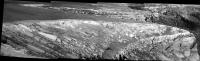
I used those new images to look instead at the distant hills. This is a composite of all six frames, enlarged 200% and merged. The real data might show some proper detail on the hills.
Phil
|
|
Posted by: nprev Jan 20 2007, 07:10 PM
http://www.novaspace.com/CARDS/PIX/comet_mars.jpg
That's the one; thanks, Stu!
It's actually by Kim Poor, then.
Posted by: diane Jan 20 2007, 10:49 PM
To be geographically, historically, and pedantically accurate, Magellan landed at Guam in Umatac Bay, his first landfall after crossing the Pacific. Fort Soledad was the Spanish fort built on the point that overlooks the bay.
I think "Umatac Bay" has a nice ring to it, but then I have my own prejudice on this.
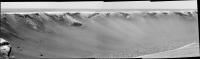
Posted by: jvandriel Jan 21 2007, 02:52 PM
Here is the L0 Navcam panoramic view from Sol 1061.
jvandriel
|
|
Posted by: hortonheardawho Jan 21 2007, 07:37 PM
http://www.flickr.com/photos/hortonheardawho/364818159/
This is three of the 9 L4/R1 pairs shot just before sunrise on sol 1063.
I tried a number of processing tricks, but didn't see a hint of McNaught. Looks like the 12 bit data will be required -- if in fact the 2665 observation was an attempt to image the comet.
Posted by: fredk Jan 22 2007, 12:53 AM
Yeah, I can see nothing in Spirit's attempt as well. Lost in the dusty haze of twilight. But the good news is McNaught's elongation from the sun is increasing rapidly now (for Mars too) and if it doesn't dim too rapidly and if the rover team decides so, we may get another chance.
Posted by: Tesheiner Jan 22 2007, 09:03 AM
Oppy drove again on sol 1064 (http://nasa.exploratorium.edu/mars/opportunity/navcam/2007-01-21/, http://nasa.exploratorium.edu/mars/opportunity/pancam/2007-01-21/).
It was a very short drive (~4m) northwards and looks like it was prematurely aborted.
Both the navcam and pancam mosaics which are taken *after* the drive is finished are centered at 126º but if you look the pancams there is obviously no further driving path on that direction. My opinion is that the initial plan was to drive by the bay and stop right at Cape Desire.
|
Posted by: antoniseb Jan 22 2007, 08:14 PM
Hmmm. I'd expected that they'd make a close inspection of 'the Dock'. My assumption was that it is there because of slippage into the crater, and there might well be some interesting strata there.
Posted by: Marz Jan 22 2007, 08:23 PM
I expected the same thing; if the "dock" is exposed from slumpage, then it's mostly unaltered from the impact and would be an easy first sample of upper layer rock that we can be sure wasn't part of the debris apron.
I wonder if the drive aborted because Oppy got nervous so near the edge?
Posted by: Tesheiner Jan 22 2007, 08:38 PM
I wouldn't rule out the dock yet. It could be the next target after Cape Desire.
Let's see what happens (tomorrow?).
Posted by: jvandriel Jan 22 2007, 08:49 PM
Here is the panoramic view from Sol 1064.
Taken with the L0 Navcam.
Great driving. Very close to the rim.
jvandriel
|
|
Posted by: mhoward Jan 23 2007, 03:30 AM
Look at this http://nasa.exploratorium.edu/mars/opportunity/pancam/2007-01-22/1P222642688EFF78ESP2355R2M1.JPG! I hadn't noticed it in the Navcam. Wonderful!
Posted by: CosmicRocker Jan 23 2007, 06:22 AM
Let's see what happens (tomorrow?).
Posted by: climber Jan 23 2007, 08:50 AM
Probably one of the most unweathered rocks lie...inside
Posted by: ustrax Jan 23 2007, 12:01 PM
Tesheiner, could you point me out where are these?:
"Sol 1062 (Jan. 18, 2007): Opportunity acquired panoramic camera images of a rock outcrop known as "Guam," exposed on the plains above the rim of Victoria Crater. The camera also photographed cobbles "Gallego," "Vasco" and "Gomes" along the rim. Opportunity acquired miniature thermal emission spectrometer data on Gallego, the soil next to Gallego, and Vasco. Plans called for Opportunity to take snapshots of comet McNaught the next morning."
That was one of the survivors, the http://www.mariner.org/exploration/index.php?type=explorersection&id=10.
I REALLY want to see where does a seaman memory lays on Mars...
Posted by: Tesheiner Jan 23 2007, 01:16 PM
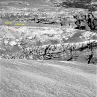
The images were not yet downlinked, only the tiny thumbnails.
Anyway, it's enough to identify those cobbles on the navcam mosaic for sol 1061. Here you have it.
|
|
Posted by: ustrax Jan 23 2007, 01:58 PM
again (see http://www.unmannedspaceflight.com/index.php?showtopic=3792&hl=If we once have a real-life UMSF BBQ you buy all beer

Thanks Tesheiner!
According to Bergreen http://209.85.135.104/search?q=cache:F5Sn6IAOfVsJ:mcgoodwin.net/pages/otherbooks/lb_overedgeworld.html+vasco+gomes+gallego+pilot+victoria&hl=pt-PT&gl=pt&ct=clnk&cd=1...
I just love this kind of fusion between History and actual Exploration...
Posted by: Tesheiner Jan 23 2007, 04:52 PM
Here you have the answer, Tom.
Fresh images from sol 1066: http://nasa.exploratorium.edu/mars/opportunity/navcam/2007-01-23/
And a navcam mosaic (3x1). The dock is on the first frame.
|
Posted by: Floyd Jan 23 2007, 04:55 PM
Is there a drive issue with Opportunity?
Posted by: Tesheiner Jan 23 2007, 05:06 PM
Due to http://nasa.exploratorium.edu/mars/opportunity/navcam/2007-01-23/1N222825995EFF78JRP1920L0M1.JPG driving pattern?
It looks something related to the front wheel steering mechanism which is no longer working.
Or maybe Oppy is a bit drunk and already celebrating its 3rd anniversary.
Posted by: Marz Jan 23 2007, 05:06 PM
Apparently something aborted the sol-1065 before it completed. They'd planned a new course, but strange that they would overshoot the dock, unless they want to start at the top layer and work down?
Posted by: fredk Jan 23 2007, 05:38 PM
Perhaps they're heading into the open and safe plains to do some drive software testing?
Or perhaps they're taking an easier route to the Cape C1-2 area, bypassing Cape Desire?
Posted by: ustrax Jan 23 2007, 05:45 PM
I gladly would...
Posted by: Tesheiner Jan 23 2007, 05:57 PM
On another topic, in http://nasa.exploratorium.edu/mars/opportunity/navcam/2007-01-23/1N222825922EFF78JRP1920L0M1.JPG we can easily see the famous dark bands at the bays C5 and D2.
Posted by: djellison Jan 23 2007, 06:11 PM
It'll be interesting to see if we get a jump in Whr's when we hit those dark streaks - my initial thought is faster winds clearing all but the fine dust leaving just dark basaltic sand + concretions behind.
Doug
Posted by: jvandriel Jan 23 2007, 07:40 PM
Added 1 image.
The panoramic view from Sol 1064.
Taken with the L0 Navcam.
jvandriel
|
Posted by: jvandriel Jan 23 2007, 08:10 PM
The other side of Victoria crater.
A panoramic view taken on Sol 1064
with the L2 Pancam.
jvandriel
|
Posted by: fredk Jan 24 2007, 03:54 AM
From http://athena1.cornell.edu/news/mubss/ the explanation of the curious tracks:
Our rover drivers, however, are nothing if not creative. If Mars doesn't give us features to look at, they figured, we'll make our own features. So recently, we've done a drive where the rover did a strange little dance as it moved along, scuffing the soil and weaving from side to side, making some of the strangest-looking rover tracks you've ever seen. (One of the maneuvers they came up with they called the "drunken sailor walk".) It looks weird, but it works. We did 40 visodom tests on that drive, and 39 of them worked. So next time you see some strange-looking wheel tracks, it's just the rover scuffing up the terrain so it can figure out where it is.
Posted by: climber Jan 24 2007, 06:32 AM
I'm amazed how creative these guys are. Looks evident now when you know it, but well.
Will be nice to see if somebody here could come up with another bright idea to help visodom. Come on guys, be creative!
Posted by: helvick Jan 24 2007, 07:23 AM
That is a fantastic bit of creative problem solving, absolutely love it.
They should start "writing" out messages in morse using this drunken sailor track - they could start with:
-- . .-. .-. ..- .-.. . ...
Posted by: Steve G Jan 24 2007, 08:08 AM
A panoramic view taken on Sol 1064
with the L2 Pancam.
jvandriel
I like the minature "Chimney Rock" feature on the far left.
Posted by: Pertinax Jan 24 2007, 01:01 PM
or maybe if Oppy is feeling a bit more poetical and ironically spry...
.. / --. .-. --- .-- / --- .-.. -.. / .-.-.- .-.-.- .-.-.- / .. / --. .-. --- .-- / --- .-.. -.. / .-.-.- .-.-.- .-.-.- / .. / ... .... .- .-.. .-.. / .-- . .- .-. / - .... . / -... --- - - --- -- ... / --- ..-. / -- -.-- / - .-. --- ..- ... . .-. ... / .-. --- .-.. .-.. . -.. .-.-.-
-- Pertinax
Posted by: RobertEB Jan 24 2007, 01:47 PM
I hope they take a look at Guam (the dock). Might be interesting.
Posted by: Tesheiner Jan 24 2007, 04:46 PM
Another "drunky" move on sol 1067: http://nasa.exploratorium.edu/mars/opportunity/rear_hazcam/2007-01-24/1R222913636EFF78PAP1312L0M1.JPG
The dock/Guam can be seen on the rhaz pic too; we just left it behind. 
There is a http://nasa.exploratorium.edu/mars/opportunity/navcam/2007-01-24/1N222914281EFF78PAP0685L0M1.JPG right now but IMO the rover is facing Cape Desire.
Posted by: RobertEB Jan 24 2007, 06:19 PM
I am curious if Guam is an uplift feature from the impact that created Victoria, or rock being exposed by material slumping down into the crater. If the latter, that would be one large slump Opportunity is driving on.
Posted by: Floyd Jan 24 2007, 06:31 PM
Pancams and additional navcams in at http://qt.exploratorium.edu/mars/opportunity/
Posted by: climber Jan 24 2007, 08:19 PM
We're a few meters below the Beacon now :

|
Did you already notice this

|
Posted by: jvandriel Jan 24 2007, 09:09 PM
Drunken Sailor track.
The panoramic view from Sol 1066.
Taken with the L0 Navcam.
jvandriel
|
|
Posted by: Phil Stooke Jan 24 2007, 09:41 PM
The latest drive reminds me of the time I put too much Irish Cream on my cornflakes.
Phil
Posted by: Pando Jan 25 2007, 01:36 AM
or maybe if Oppy is feeling a bit more poetical and ironically spry...
.. / --. .-. --- .-- / --- .-.. -.. / .-.-.- .-.-.- .-.-.- / .. / --. .-. --- .-- / --- .-.. -.. / .-.-.- .-.-.- .-.-.- / .. / ... .... .- .-.. .-.. / .-- . .- .-. / - .... . / -... --- - - --- -- ... / --- ..-. / -- -.-- / - .-. --- ..- ... . .-. ... / .-. --- .-.. .-.. . -.. .-.-.-
-- Pertinax
http://www.usask.ca/english/prufrock/prufrock15.wav
Posted by: Tesheiner Jan 25 2007, 10:03 AM
It was imaged yestersol (1067) but not yet downlinked.
01067::p2570::17::2::2::0::0::2::6::pancam_guam_LOCO_L7R1
It can be barely seen on http://marsrovers.jpl.nasa.gov/gallery/all/1/p/953/1P212789163EFF76EVP2390L2M1.JPG part of the Duck Bay panorama.
And on Cape Verde http://marsrovers.jpl.nasa.gov/gallery/all/1/p/986/1P215722175EFF76POP2416L2M1.JPG too.
Posted by: jamescanvin Jan 29 2007, 03:42 AM
As we move out onto Cape Desire it looks like the focus is on the next bay, Bahia Blanca. Posts from the last few sols moved to a http://www.unmannedspaceflight.com/index.php?showtopic=3827 for this bay.
Posted by: CosmicRocker Jan 31 2007, 06:41 AM
Yipee! The http://en.wikipedia.org/wiki/(Sittin'_On)_the_Dock_of_the_Bay came down today, and there we were, (Sittin' on) the Dock of the Bay.
I have been praying for these pancams for a while, and I think it's a very nice scene. I was hoping for more, but I'll take an L7R1 pair any day. The Dock seems to be one of the several ejecta layers which has been eroded back. For some time I have been wondering why the ejecta seemed to be layered, but it makes sense that stuff was thrown out of the crater by processes that created overlapping layers.
Anyway, that's what it looks like to me. Here is the anaglyph of the feature otherwise known as Guam.

|
I couldn't help but wonder what the rubble pile in the distance was, so I will also include a HiRise image with my best guess as to where that is.

|
Posted by: Tesheiner Jan 31 2007, 09:31 AM
I was doing my usual early morning (GMT+1) lookup at the exploratorium looking for "fresh" yestersol images of Opportunity and just found old ones. I simply forgot about those missing (and long waiting) "LOCO" images of the dock. Thanks Tom for the reminder.
I agree with your guess for the rubble pile position. About our current position, it's well out of the fov to the right and more on the foreground then at the background. Here are two navcams on that same heading (a much bigger fov, of course!) for reference. I think that the cape visible on the background at a lower elevation on the "loco" pancam is C3.
http://marsrovers.jpl.nasa.gov/gallery/all/1/n/1066/1N222825922EFF78JRP1920L0M1.JPG http://marsrovers.jpl.nasa.gov/gallery/all/1/n/1066/1N222825958EFF78JRP1920L0M1.JPG
Posted by: ngunn Jan 31 2007, 01:58 PM
I hope somebody does a nice (perspective?) merge of those two navcam shots. I've just had a go with scissors and sticky tape and the result is a highly satisfying landscape composition. The whole scene is very clearly laid out before the eye all the way from Dock to Soup Dragon. The downcurving profile of the apron off to the left is striking too.
Posted by: Tesheiner Jan 31 2007, 02:31 PM
You have not only two but five navcams in Jvandriel's mosaic (post #124 above).
Posted by: CosmicRocker Jan 31 2007, 03:21 PM
Yes, Tesheiner...C3. I jumped to a conclusion when I saw that pointed cape, even though the current location couldn't possiblly be along that line of site.
Posted by: ngunn Jan 31 2007, 03:49 PM
So we do!!!!! Thanks. However for some reason the relevant part of that looks a lot less compelling that what I've just printed off and stuck together. I don't know if its the scale, the contrast or what. In case anybody wants to try it here is the very simple recipe:
I printed the 2 images in your post on A4 in landscape format, which had the effect of cropping off the bottom third of each. I then trimmed off only the right white margin of the left hand image and stuck them together to give a straight horizon with the middle distance matched as well as possible. The result is a picture, 47cm by17cm with ready-made white margin, which is going on my wall!
Posted by: jamescanvin Feb 5 2007, 12:42 PM
Other versions were posted in the Bahia Blanca thread but this really belongs here.
My version of the stunning 5pm view from Cabo Anonimo.
http://www.physics.usyd.edu.au/~jcanvin/mer/index.html#B1063
I can't wait for one of you colouring in folks to attack this view.
James.
And that brings up the big 1000 posts. Still, can't keep up with Spirit or Oppy sols though.
Posted by: ustrax Feb 5 2007, 01:40 PM
Stunning is truly the word!
This is the vista that for me provided the best sense of Victoria's dimensions!
Thanks James!
Posted by: Nirgal Feb 5 2007, 02:33 PM
My version of the stunning 5pm view from Cabo Anonimo.
James.
OMG Seems that I'm missing quite a bit here
How often have I said "this must be the greatest of Oppy's image yet" ... but this one is now definitiely
my NUMBER ONE most fascinating view taken by the Opportunity Rover, if not from the surface of mars at all to date (perhaps only rivaled by Spirit's famous "multi-dust-devil movie")
I especially like the late-afternoon-shadows and the bizarre overall look of the scenery, even with rover tracks to add that sense of scale ... WOW again...
Can't wait to try a colorization at this one
Posted by: Tesheiner Feb 5 2007, 02:34 PM
Welcome to the "Part of the furniture" group, James.
Ooops, that's only for the 5000+ posts.
Posted by: Floyd Feb 5 2007, 04:57 PM
James, that is a fantastic image. In looking at the dark material, it doesn't look like it could possibly be due to wind action removing a lighter cover--it almost looks as if the darker material is leaking out of the rocks above. For example, see the Soup Dragon, or Cape E1-E2. Anyone want to speculate on this?
Thanks,
Floyd
Posted by: ngunn Feb 5 2007, 05:12 PM
Floyd
I agree, that is how it looks. Wasn't there once mention of a possible igneous dike somewhere around here?
Posted by: Tesheiner Feb 5 2007, 05:31 PM
My take is for a similar mechanism as the one maintaining El Dorado.
Posted by: Steve Feb 5 2007, 08:46 PM
James
The rover tracks, on both the near and far side of the Bay of Toil, really give a sense of perspective -- and of having been there. Nicely done.
Steve
Posted by: jamescanvin Feb 6 2007, 03:47 AM
Thanks all.
The Cape Desire images from Cabo Anonimo have now been downlinked.
http://www.physics.usyd.edu.au/~jcanvin/mer/index.html#B1060
James
Posted by: Ant103 Feb 6 2007, 04:48 PM
Superb James
My own version
http://www.astrosurf.com/merimages/Images_opportunity-2007.html#Sol1060
The images are too deform by Autostitch sadly
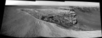
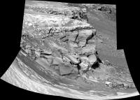
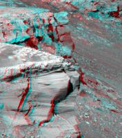
Posted by: fredk Feb 8 2007, 07:08 PM
Here's a long-baseline anaglyph of the tip of Cape Desire and Hoy behind it from across the Bay of Toil. Pancam L2 and R2. Taken sols 1060 and 1061, but before the drives both sols, so positions are marked 1058 and 1060 on the route map:
|
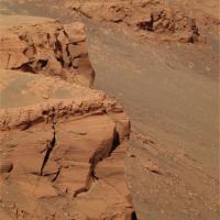
Posted by: fredk Feb 8 2007, 10:42 PM
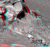
Here's the adjoining view just below the previous one. Stunning wind-sculpted hunks of rock.
|
Powered by Invision Power Board (http://www.invisionboard.com)
© Invision Power Services (http://www.invisionpower.com)