Opportunity Route Map |

  |
Opportunity Route Map |
 Nov 15 2016, 07:20 PM Nov 15 2016, 07:20 PM
Post
#3451
|
||
|
Solar System Cartographer  Group: Members Posts: 10160 Joined: 5-April 05 From: Canada Member No.: 227 |
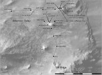
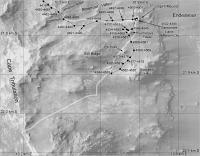
And another drive, sol 4554.
Phil
-------------------- ... because the Solar System ain't gonna map itself.
Also to be found posting similar content on https://mastodon.social/@PhilStooke Maps for download (free PD: https://upload.wikimedia.org/wikipedia/comm...Cartography.pdf NOTE: everything created by me which I post on UMSF is considered to be in the public domain (NOT CC, public domain) |
|
 |
 
|
|
|
Nov 17 2016, 09:25 PM
Post
#3452
|
||
|
Solar System Cartographer Group: Members Posts: 10160 Joined: 5-April 05 From: Canada Member No.: 227 |
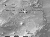
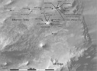
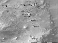
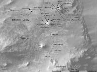
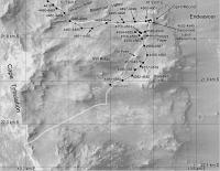
Opportunity drove back towards Pompy's Tower on sol 4556, as shown approximately here. When we have more images I may get a better position.
Phil
-------------------- ... because the Solar System ain't gonna map itself.
Also to be found posting similar content on https://mastodon.social/@PhilStooke Maps for download (free PD: https://upload.wikimedia.org/wikipedia/comm...Cartography.pdf NOTE: everything created by me which I post on UMSF is considered to be in the public domain (NOT CC, public domain) |
|
|
|
|
|
|
Nov 18 2016, 11:22 PM
Post
#3453
|
||
|
Member Group: Members Posts: 808 Joined: 10-October 06 From: Maynard Mass USA Member No.: 1241 |
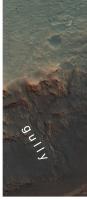
*** didn't quite know where to put this ***
Following up on the gully target coming up in a few months... Here is the gully from a slightly different perspective (90 rotation makes it look scary steep!) from: PIA20854
-------------------- CLA CLL
|
|
|
|
|
|
|
Nov 18 2016, 11:34 PM
Post
#3454
|
|
 Administrator Group: Admin Posts: 5172 Joined: 4-August 05 From: Pasadena, CA, USA, Earth Member No.: 454 |
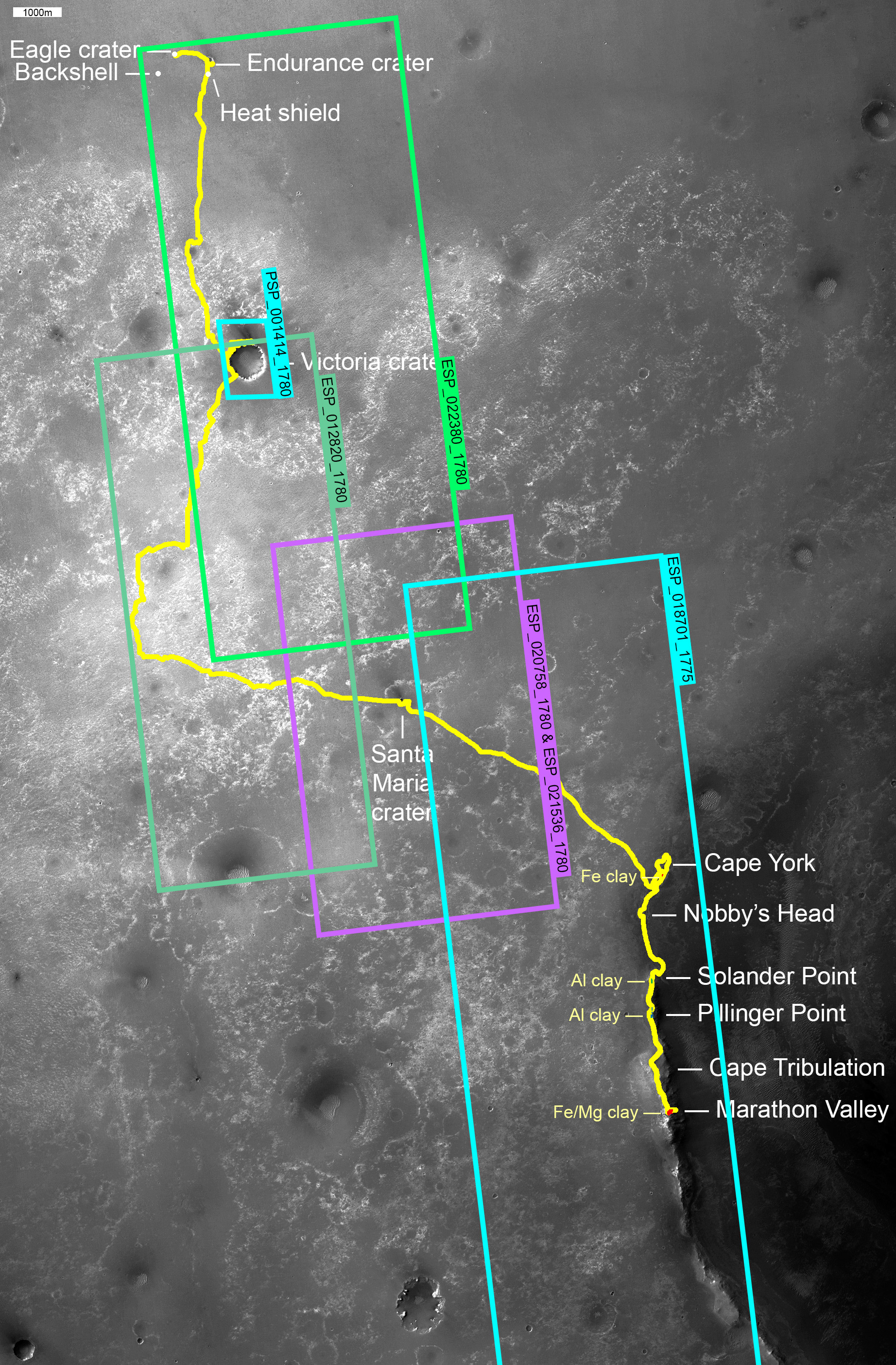
A wider take on the route map -- I finally finished doing for Opportunity what I did for Curiosity a while ago, organizing the collection of HiRISE images covering the traverse.
-------------------- My website - My Patreon - @elakdawalla on Twitter - Please support unmannedspaceflight.com by donating here.
|
|
|
|
|
Nov 20 2016, 07:49 PM
Post
#3455
|
||
|
Solar System Cartographer Group: Members Posts: 10160 Joined: 5-April 05 From: Canada Member No.: 227 |
Very nice, Emily.
Here is an update to sol 4559, driving past Pompy's Tower. Phil
PS Watch this space for a big route map announcement coming soon. Fear not, it's a good announcement, if I can get it to work. -------------------- ... because the Solar System ain't gonna map itself.
Also to be found posting similar content on https://mastodon.social/@PhilStooke Maps for download (free PD: https://upload.wikimedia.org/wikipedia/comm...Cartography.pdf NOTE: everything created by me which I post on UMSF is considered to be in the public domain (NOT CC, public domain) |
|
|
|
|
|
|
Nov 27 2016, 10:34 PM
Post
#3456
|
||
|
Solar System Cartographer Group: Members Posts: 10160 Joined: 5-April 05 From: Canada Member No.: 227 |
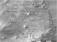
Sol 4566, a nice drive about 17 m SSE - the location is only approximate until I see more images.
Phil
-------------------- ... because the Solar System ain't gonna map itself.
Also to be found posting similar content on https://mastodon.social/@PhilStooke Maps for download (free PD: https://upload.wikimedia.org/wikipedia/comm...Cartography.pdf NOTE: everything created by me which I post on UMSF is considered to be in the public domain (NOT CC, public domain) |
|
|
|
|
|
|
Nov 30 2016, 05:52 PM
Post
#3457
|
|
|
Newbie Group: Members Posts: 14 Joined: 25-August 09 Member No.: 4913 |
QUOTE (elakdawalla @ Nov 18 2016, 03:34 PM)  A wider take on the route map -- I finally finished doing for Opportunity what I did for Curiosity a while ago, organizing the collection of HiRISE images covering the traverse. Great work and excellent article. |
|
|
|
|
Nov 30 2016, 11:36 PM
Post
#3458
|
||
|
Solar System Cartographer Group: Members Posts: 10160 Joined: 5-April 05 From: Canada Member No.: 227 |
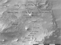
Another drive on sol 4568 - moving below the third mound in this area. Very soon it will be possible to drive up the hill between it and the big ridge to the south.
Phil
-------------------- ... because the Solar System ain't gonna map itself.
Also to be found posting similar content on https://mastodon.social/@PhilStooke Maps for download (free PD: https://upload.wikimedia.org/wikipedia/comm...Cartography.pdf NOTE: everything created by me which I post on UMSF is considered to be in the public domain (NOT CC, public domain) |
|
|
|
|
|
|
Dec 2 2016, 01:06 PM
Post
#3459
|
||
|
Solar System Cartographer Group: Members Posts: 10160 Joined: 5-April 05 From: Canada Member No.: 227 |
Sol 4570 - and we are going round the bend. So to speak. Turning towards the uphill path. My placename 'SW Ridge' is an imaging target from the time at Spirit Mound, but I'm not sure it is really in the right place.
Phil
-------------------- ... because the Solar System ain't gonna map itself.
Also to be found posting similar content on https://mastodon.social/@PhilStooke Maps for download (free PD: https://upload.wikimedia.org/wikipedia/comm...Cartography.pdf NOTE: everything created by me which I post on UMSF is considered to be in the public domain (NOT CC, public domain) |
|
|
|
|
|
|
Dec 9 2016, 01:15 PM
Post
#3460
|
||
|
Solar System Cartographer Group: Members Posts: 10160 Joined: 5-April 05 From: Canada Member No.: 227 |
Another drive uphill on sol 4577, a bit over 11 m.
Phil
PS I think the name SW Ridge fits better where I have it now, looking back at when it was used. But if anyone can correct me... -------------------- ... because the Solar System ain't gonna map itself.
Also to be found posting similar content on https://mastodon.social/@PhilStooke Maps for download (free PD: https://upload.wikimedia.org/wikipedia/comm...Cartography.pdf NOTE: everything created by me which I post on UMSF is considered to be in the public domain (NOT CC, public domain) |
|
|
|
|
|
|
Dec 12 2016, 03:02 PM
Post
#3461
|
||
|
Solar System Cartographer Group: Members Posts: 10160 Joined: 5-April 05 From: Canada Member No.: 227 |
A 15 m drive on sol 4580, taking us up the valley. I might be a few metres NW of our actual location, need more images to check it. Also a feature name, Elwood - I don't yet know what it refers to.
Phil
-------------------- ... because the Solar System ain't gonna map itself.
Also to be found posting similar content on https://mastodon.social/@PhilStooke Maps for download (free PD: https://upload.wikimedia.org/wikipedia/comm...Cartography.pdf NOTE: everything created by me which I post on UMSF is considered to be in the public domain (NOT CC, public domain) |
|
|
|
|
|
|
Dec 14 2016, 05:39 PM
Post
#3462
|
||
|
Solar System Cartographer Group: Members Posts: 10160 Joined: 5-April 05 From: Canada Member No.: 227 |
Another drive on sol 4582 (plus a correction to the previous drive). Time for a new map base.
Phil
-------------------- ... because the Solar System ain't gonna map itself.
Also to be found posting similar content on https://mastodon.social/@PhilStooke Maps for download (free PD: https://upload.wikimedia.org/wikipedia/comm...Cartography.pdf NOTE: everything created by me which I post on UMSF is considered to be in the public domain (NOT CC, public domain) |
|
|
|
|
|
|
Dec 17 2016, 11:49 PM
Post
#3463
|
||
|
Solar System Cartographer Group: Members Posts: 10160 Joined: 5-April 05 From: Canada Member No.: 227 |
Another drive uphill on sol 4584, just fitting on to this map before I change the base. I made several small corrections to match the latest map on the MER website.
Phil
-------------------- ... because the Solar System ain't gonna map itself.
Also to be found posting similar content on https://mastodon.social/@PhilStooke Maps for download (free PD: https://upload.wikimedia.org/wikipedia/comm...Cartography.pdf NOTE: everything created by me which I post on UMSF is considered to be in the public domain (NOT CC, public domain) |
|
|
|
|
|
|
Dec 18 2016, 12:08 AM
Post
#3464
|
||
|
Solar System Cartographer Group: Members Posts: 10160 Joined: 5-April 05 From: Canada Member No.: 227 |
This is just a bit of a wider view of the current area, showing also the route shown in the extended mission plan (white line).
Phil
-------------------- ... because the Solar System ain't gonna map itself.
Also to be found posting similar content on https://mastodon.social/@PhilStooke Maps for download (free PD: https://upload.wikimedia.org/wikipedia/comm...Cartography.pdf NOTE: everything created by me which I post on UMSF is considered to be in the public domain (NOT CC, public domain) |
|
|
|
|
|
|
Dec 18 2016, 06:35 PM
Post
#3465
|
||
|
Solar System Cartographer Group: Members Posts: 10160 Joined: 5-April 05 From: Canada Member No.: 227 |
Another 30 m on sol 4586, getting up to some nice outcrops of brighter material. There's a rocky bluff just above us, so do we go to the left or right of it? Right is straight up the hill, pretty steep, maybe too steep at one particular spot. Left is south, across a field of small blocks which is probably a recent rockfall deposit, but not as blocky as the one below SW Ridge.
Phil
-------------------- ... because the Solar System ain't gonna map itself.
Also to be found posting similar content on https://mastodon.social/@PhilStooke Maps for download (free PD: https://upload.wikimedia.org/wikipedia/comm...Cartography.pdf NOTE: everything created by me which I post on UMSF is considered to be in the public domain (NOT CC, public domain) |
|
|
|
|
|
|

|
Lo-Fi Version | Time is now: 11th May 2024 - 08:50 AM |
|
RULES AND GUIDELINES Please read the Forum Rules and Guidelines before posting. IMAGE COPYRIGHT |
OPINIONS AND MODERATION Opinions expressed on UnmannedSpaceflight.com are those of the individual posters and do not necessarily reflect the opinions of UnmannedSpaceflight.com or The Planetary Society. The all-volunteer UnmannedSpaceflight.com moderation team is wholly independent of The Planetary Society. The Planetary Society has no influence over decisions made by the UnmannedSpaceflight.com moderators. |
SUPPORT THE FORUM Unmannedspaceflight.com is funded by the Planetary Society. Please consider supporting our work and many other projects by donating to the Society or becoming a member. |
|