Printable Version of Topic
Click here to view this topic in its original format
Unmanned Spaceflight.com _ MSL _ MSL landing site ephemeris
Posted by: Tom O'Reilly Aug 6 2012, 03:57 PM
Does anyone know where I can access a daily ephemeris for the Curiosity landing site? E.g. Sun rise/set, Earth rise/set, MRO/Odyssey/Mars Express transits, etc?
Thanks,
Tom
Posted by: Adam Hurcewicz Aug 6 2012, 05:20 PM

Thanks,
Tom
Hi, i use Guide software to calculate sunrise/sunset on Mars
Sunrise at 20:10 UTC - Transit (Alt 74°) at 02:15 UTC - Sunset at 08:20 CET
Earth rise at 17:45 UTC - Transit (Alt 62°) at 23:45 UTC - set at 05:45 CET
MRO/Odyssey/Mars Express I don't know, I don't have good orbital data of this.
Adam
Posted by: jmknapp Aug 6 2012, 05:39 PM
It can be calculated with the http://naif.jpl.nasa.gov/naif/data_mars.html. If such a facility is not already available maybe I'll set up a web page.
Posted by: Tom O'Reilly Aug 6 2012, 05:58 PM
Sunrise at 20:10 UTC - Transit (Alt 74°) at 02:15 UTC - Sunset at 08:20 CET
Earth rise at 17:45 UTC - Transit (Alt 62°) at 23:45 UTC - set at 05:45 CET
MRO/Odyssey/Mars Express I don't know, I don't have good orbital data of this.
Very cool Adam - what is "Guide" software? (LOTS of google results searching for that!)
Does anyone know of a publicly-accessible MSL surface operations page or other resource that would include this information?
Thanks,
Tom
Posted by: Adam Hurcewicz Aug 7 2012, 07:44 AM
It's here http://www.projectpluto.com
Very good soft.
Adam
Posted by: jmknapp Aug 8 2012, 11:50 AM
I made an almanac up through Sept. 30 showing the MRO, ODY and MEX passes along with sun/earth rise and set:
http://mslfan.com/2012/08/08/msl-almanac/
Times are UT. If you click on the google calendar button on the lower right you can add it to your own google calendar & display times in other time zones.
The data are based on the most current SPICE kernels published on http://naif.jpl.nasa.gov/naif/data_mars.html and are predictions subject to change.
Posted by: Reckless Aug 8 2012, 12:35 PM
Very good and very useful.
Thanks Joe
Roy F
Posted by: Tom O'Reilly Aug 8 2012, 03:07 PM
Fantastic - thank you!
Posted by: Adam Hurcewicz Aug 8 2012, 03:34 PM
Very good job, Joe! Thank you !
Posted by: lyford Aug 8 2012, 04:41 PM
Thanks Joe!
Posted by: elakdawalla Aug 8 2012, 04:45 PM
Super!
Posted by: jmknapp Aug 9 2012, 12:52 AM
Hopefully there aren't any bugs--open to suggestions for V2. Emily asked for a basic table showing the UTC for sunrise, sunset, etc. Here it is for the first 1000 sols (see attached zip file): msl_sundata.zip ( 29.41K )
: 704
msl_sundata.zip ( 29.41K )
: 704
Posted by: elakdawalla Aug 9 2012, 02:10 AM
Marvelous. Thank you!
Posted by: jmknapp Aug 9 2012, 11:45 AM
I should point out that that table reckons the start of each sol from midnight LTST (local true solar time), i.e., when the sun actually crosses the meridian. I since gather that the landed missions use LMST (local mean solar time).
From http://www.giss.nasa.gov/tools/mars24/credits.html
LMST diverges from LTST over the year as Mars speeds up and slows down in its eccentric orbit. The difference can be as much as 51 minutes.
Also, as I understand the practice, the local time reference is not adjusted as the rover moves, but is fixed at some "http://en.wikipedia.org/wiki/Timekeeping_on_Mars" so to speak, e.g., AMT+11:00:04 for Spirit.
Maybe that table needs to be redone, as soon as I can find out for sure how JPL defines the start of each MSL sol. At least, the sunrise and sunset UTC times are accurate
Posted by: mcaplinger Aug 9 2012, 01:20 PM
See ftp://naif.jpl.nasa.gov/pub/naif/MSL/kernels/sclk/msl_lmst_gc120806_v3.tsc
Posted by: jmknapp Aug 10 2012, 01:34 PM
Thanks!--didn't know that file existed.
So here's the MSL sol ephemeris recomputed using LMST:
msl_sundataV2.zip ( 33.04K )
: 765Posted by: jmknapp Aug 21 2012, 10:50 AM
It's probably more convenient to have the sun ephemeris as a web page:
http://curiositymsl.com/sundata
That table covers the nominal mission of one Mars year (668 sols).
Posted by: Oersted Aug 27 2012, 10:56 AM
I´ll be the one to say it: Thanks a 1,000,000 jmknapp! The raw-image addicts in this forum will find this most helpful!
Posted by: scalbers Aug 17 2016, 06:00 PM
Greetings,
I wonder if there's any simple way to obtain the Sun's elevation and azimuth angle as seen from Curiosity? This would help in filling in the sky in some of the panoramas. Some of the earlier tables in this thread are helpful, though it seems they would need to be extended.
Thanks,
Steve
Posted by: nogal Aug 17 2016, 06:36 PM
Hello scalbers.
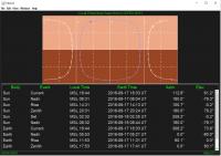
A search on the web turned up this simple BASIC program [http://www.spaceacademy.net.au/spacelab/projects/marsclok/marsclok.htm] by the Australian Space Academy.
Also check The Mars Clock by NASA/GISS. Install it, in case you do not have already.
- On the "Settings" windows select the "Plot" tab
- Enter or select the following values for the variables:
- Plot: Local Panorama
- Type: Lander Mission
- Lander Site: MSL Curiosity
- Plot Elements: Graphic and Data
- From the major menu bar select "View" then "Panorama" from the pull down menu
- From the major menu bar select "Window" then "Plot" from the pull down menu
Fernando
|
Posted by: fredk Aug 17 2016, 07:28 PM
There's also the http://www.greuti.ch/msl/clock_and_filenames.htm website from a member of this forum. It has the advantage that you just enter the navcam filename and it gives you the solar el/az etc.
Posted by: verfkwast Jan 20 2017, 06:33 PM
thanks
Powered by Invision Power Board (http://www.invisionboard.com)
© Invision Power Services (http://www.invisionpower.com)