Endeavour Drive - Drivability analysis |

  |
Endeavour Drive - Drivability analysis |
 Oct 6 2008, 08:47 PM Oct 6 2008, 08:47 PM
Post
#496
|
|
 Senior Member  Group: Members Posts: 1229 Joined: 24-December 05 From: The blue one in between the yellow and red ones. Member No.: 618 |
Cool, the way the image color scheme matches your avatar, JM!
You must have seen this task coming long ago.  What is your avatar BTW? -------------------- My Grandpa goes to Mars every day and all I get are these lousy T-shirts!
|
 |
 
|
|
Oct 6 2008, 08:57 PM
Post
#497
|
|
|
Senior Member Group: Members Posts: 2918 Joined: 14-February 06 From: Very close to the Pyrénées Mountains (France) Member No.: 682 |
QUOTE (Shaka @ Oct 6 2008, 10:47 PM)  What is your avatar BTW? Research Triangle (Park) of some sort I guess -------------------- |
|
|
|
|
Oct 6 2008, 09:49 PM
Post
#498
|
|
 Senior Member Group: Moderator Posts: 2785 Joined: 10-November 06 From: Pasadena, CA Member No.: 1345 |
QUOTE (Shaka @ Oct 6 2008, 04:47 PM) What is your avatar BTW? Pretty nerdly. It is a set of five elements: (from clockwise upper right) Air, Fire, Earth, Wind, and (center) Gaia (lifeforce). -Mike (Actually, at this point in my career I'm pretty pleased that I've used 45 of the elements of the Periodic table. Scoring Lanthanide points was tough .)
-------------------- Some higher resolution images available at my photostream: http://www.flickr.com/photos/31678681@N07/
|
|
|
|
|
Oct 6 2008, 09:50 PM
Post
#499
|
||
|
Senior Member Group: Moderator Posts: 2785 Joined: 10-November 06 From: Pasadena, CA Member No.: 1345 |
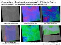
Comparison images of UMSF terrain maps to date of area S of Victoria:
-Mike -------------------- Some higher resolution images available at my photostream: http://www.flickr.com/photos/31678681@N07/
|
|
|
|
|
|
|
Oct 6 2008, 09:52 PM
Post
#500
|
|
 Senior Member Group: Members Posts: 1887 Joined: 20-November 04 From: Iowa Member No.: 110 |
I think overlaying two HiRES images taken during different seasons could help identify terrain where the ground has a modest slope to the north-south. The areas where the elevation increases to the south should be brighter during the northern summer than during the norther winter.
|
|
|
|
|
Oct 6 2008, 11:16 PM
Post
#501
|
|
 Member Group: Members Posts: 524 Joined: 24-November 04 From: Heraklion, GR. Member No.: 112 |
QUOTE (Juramike @ Oct 7 2008, 12:49 AM) Pretty nerdly. It is a set of five elements: (from clockwise upper right) Air, Fire, Earth, Wind, and (center) Gaia (lifeforce). Gaia ? I thought Milla Jovovich was the 5th element ! 
|
|
|
|
|
Oct 7 2008, 01:01 AM
Post
#502
|
||
|
Senior Member Group: Moderator Posts: 2785 Joined: 10-November 06 From: Pasadena, CA Member No.: 1345 |
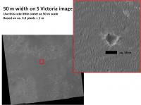
Pixel counts of the (full?) res HiRise version that have been linked in this thread:
Endurance = 634 pixels across = 200 m = 3.2 pixels/m I'll use 3.3 pixels/m as an estimate for the full res HiRise images we've been dealing with. (This makes the big scary dune wavelength = 22 pixels = 6.6 m wavelength = 3 Oppy lengths) In the S Victoria HiRise region there is a very cute crater that is about 180 pixels diameter = ca. 55 m. We can use this as a measuring stick for the 50 m corridor. (Does this little guy have a name?)
-Mike -------------------- Some higher resolution images available at my photostream: http://www.flickr.com/photos/31678681@N07/
|
|
|
|
|
|
|
Oct 7 2008, 01:12 AM
Post
#503
|
|
|
Senior Member Group: Members Posts: 1229 Joined: 24-December 05 From: The blue one in between the yellow and red ones. Member No.: 618 |
That crater's not only cute, it looks like a classic cluster impact. Good place to look for pieces of impactor!
I'd give it a gold star. -------------------- My Grandpa goes to Mars every day and all I get are these lousy T-shirts!
|
|
|
|
|
Oct 7 2008, 03:32 AM
Post
#504
|
|
|
Junior Member Group: Members Posts: 27 Joined: 22-September 08 Member No.: 4349 |
QUOTE (Shaka @ Oct 6 2008, 07:12 PM) That crater's not only cute, it looks like a classic cluster impact. Good place to look for pieces of impactor! I'd give it a gold star. Yes, I agree that this "bad boy" deserves a closer look if it can be reached without excessive risk. (See posts #143, #209, and #222.) If someone were to provide me with a nice image directly to the south of the one shown in post #222, I can show you how one person believes we can get there. |
|
|
|
|
Oct 7 2008, 04:33 AM
Post
#505
|
|
 Senior Member Group: Members Posts: 2228 Joined: 1-December 04 From: Marble Falls, Texas, USA Member No.: 116 |
QUOTE (TheChemist @ Oct 6 2008, 06:16 PM) Gaia ? I thought Milla Jovovich was the 5th element ! While Sagan's Contact remains my all time favorite science fiction story; Leeloo, Bruce Willis, and the 5th Element are also on my favorites list. -------------------- ...Tom
I'm not a Space Fan, I'm a Space Exploration Enthusiast. |
|
|
|
|
Oct 7 2008, 04:49 AM
Post
#506
|
||
|
Senior Member Group: Moderator Posts: 2785 Joined: 10-November 06 From: Pasadena, CA Member No.: 1345 |
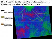
Trying to minimize the red/blue areas and maximize the green (smooth low-ripple sand), I whipped up some possible routes that have the longest corridors of "green" smooth sand. These are very risk averse. (Even minimizing pavement with possible dune ripples or cracks)
The boxes are ca. 50 m on a side. (4 boxes would be a good day of driving). Black boxes show a preferred route, yellow acceptable routes, orange routes are still risk-averse but may cross a few tougher areas or be longer.
These were all checked by myself in the hi-res imagery. (Yup, smooth sand). I also uploaded higher-resolution images and overlays on the speedyshare server (the colored boxes on the hi-res maps didnt transfer over very well):: Proposed routes overlaid on HiRise imagery at 12.5% resolution (30.2 Mb .tif file): http://www.speedyshare.com/569973455.html Proposed routes overlaid on colorized differential shift graphic with terrain overlay at 12.5% resolution (30.2 Mb .tif file): http://www.speedyshare.com/378217128.html Proposed routes overlaid on colorized differential-shift terrain map with no overlay at 12.5% resolution (30.2 Mb .tif file): http://www.speedyshare.com/125370328.html -Mike -------------------- Some higher resolution images available at my photostream: http://www.flickr.com/photos/31678681@N07/
|
|
|
|
|
|
|
Oct 7 2008, 07:46 AM
Post
#507
|
|
|
Senior Member Group: Moderator Posts: 4279 Joined: 19-April 05 From: .br at .es Member No.: 253 |
QUOTE (Juramike @ Oct 7 2008, 03:01 AM) Pixel counts of the (full?) res HiRise version that have been linked in this thread: Endurance = 634 pixels across = 200 m = 3.2 pixels/m I'll use 3.3 pixels/m as an estimate for the full res HiRise images we've been dealing with. (This makes the big scary dune wavelength = 22 pixels = 6.6 m wavelength = 3 Oppy lengths) AFAIK, these map projected HiRISE pictures have a resolution of 25cm/pix (4 pix/m). Check the "observation toolbox" for e.g. PSP_001414_1780 and PSP_009141_1780. |
|
|
|
|
Oct 7 2008, 01:37 PM
Post
#508
|
|
 Senior Member Group: Members Posts: 4246 Joined: 17-January 05 Member No.: 152 |
QUOTE (Juramike @ Oct 7 2008, 05:49 AM) I whipped up some possible routes that have the longest corridors of "green" smooth sand. Did you take into account that driving directly north-south between larger ripples may be easier than driving diagonally across smaller ripples? I might have chosen a route that goes directly south where ripples are questionable and goes southeastish where the driving is good. But I guess the question of how small do ripples need to be before we can safely cross them diagonally is something a rover driver knows best... |
|
|
|
|
Oct 7 2008, 01:42 PM
Post
#509
|
|
|
Solar System Cartographer Group: Members Posts: 10146 Joined: 5-April 05 From: Canada Member No.: 227 |
Mike - as soon as you get off the green areas, you are limited in the direction you can move, with due south being preferred, and absolutely essential as the terrain gets rougher. I think your preferred route would actually be very difficult where you head eastwards off the Victoria ejecta.
There are three south-pointing extensions of the smooth ejecta, south of the crater. Any one will give you a good start, but I think the western one gives a shorter route through the worst area. Phil -------------------- ... because the Solar System ain't gonna map itself.
Also to be found posting similar content on https://mastodon.social/@PhilStooke NOTE: everything created by me which I post on UMSF is considered to be in the public domain (NOT CC, public domain) |
|
|
|
|
Oct 7 2008, 02:12 PM
Post
#510
|
|
|
Senior Member Group: Moderator Posts: 2785 Joined: 10-November 06 From: Pasadena, CA Member No.: 1345 |
The proposed routes were designed to allow maximum drive direction flexibility and safety within the 50 m box. I tried my best to avoid any dune crests. My goal was to find the most "parking lot"-like terrain possible. (....must...avoid...red...zones....)
While a straight S course through a bad section (red zone) might be easier (and faster), extra-careful planning will be necessary. And Oppy won't be able to deviate easily from inside a deep trough. However one gets through the Victoria S debris apron, the intersection point of all the proposed paths looks like the natural "drain" leading towards the green parking lot terrain in the SE section of the image. -Mike -------------------- Some higher resolution images available at my photostream: http://www.flickr.com/photos/31678681@N07/
|
|
|
|
|

|
Lo-Fi Version | Time is now: 20th April 2024 - 12:39 AM |
|
RULES AND GUIDELINES Please read the Forum Rules and Guidelines before posting. IMAGE COPYRIGHT |
OPINIONS AND MODERATION Opinions expressed on UnmannedSpaceflight.com are those of the individual posters and do not necessarily reflect the opinions of UnmannedSpaceflight.com or The Planetary Society. The all-volunteer UnmannedSpaceflight.com moderation team is wholly independent of The Planetary Society. The Planetary Society has no influence over decisions made by the UnmannedSpaceflight.com moderators. |
SUPPORT THE FORUM Unmannedspaceflight.com is funded by the Planetary Society. Please consider supporting our work and many other projects by donating to the Society or becoming a member. |
|