Post Conjunction: Santa Maria to Cape York, The Journey to 'Spirit Point' |

  |
Post Conjunction: Santa Maria to Cape York, The Journey to 'Spirit Point' |
 Jul 21 2011, 07:16 PM Jul 21 2011, 07:16 PM
Post
#991
|
|
 Senior Member  Group: Members Posts: 4247 Joined: 17-January 05 Member No.: 152 |
A bit of info (and a nod to our Stu!) explaining the recent short drive over at the new insider's blog:
QUOTE For sol 2662, it was a combination of the science team wanting to stop short for the next crater set [Stu: it's named Mariner 9! They have a name!] and being limited by the data that had been downlinked by the time the drive needed to be planned.
|
 |
 
|
|
Jul 21 2011, 11:28 PM
Post
#992
|
||
 Member Group: Members Posts: 404 Joined: 5-January 10 Member No.: 5161 |
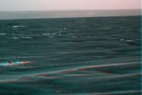
Managed to tease out this pan-cam 3D from today's downlink (R-hand image had very poor contrast).
One big hole coming up! (Though probably more a dusty and dune-rippled plain, flat and wide. With a touch of terraforming, perhaps one day a prairie  ). ).
|
|
|
|
|
|
|
Jul 21 2011, 11:37 PM
Post
#993
|
||
 Senior Member Group: Members Posts: 1619 Joined: 12-February 06 From: Bergerac - FR Member No.: 678 |
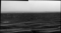
A part of the upcomming pan (I think).
Isn't it a part of Iazu Crater we can see at the right part of the pan, behind the hills of the south rim of Endeavour ?
Attached thumbnail(s)
-------------------- |
|
|
|
|
|
|
Jul 22 2011, 01:05 AM
Post
#994
|
|||
 Senior Member Group: Admin Posts: 3108 Joined: 21-December 05 From: Canberra, Australia Member No.: 615 |
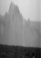
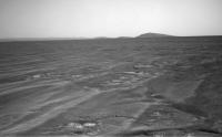
If those headings are correct then I think I'm ready to call....LAND HO!!
 Super stretched animated gif:
The wider view animated gif:
|
||
|
|
|
||
|
Jul 22 2011, 01:55 AM
Post
#995
|
|
|
Solar System Cartographer Group: Members Posts: 10161 Joined: 5-April 05 From: Canada Member No.: 227 |
Right - that can't be anything but Cape York now!
Phil -------------------- ... because the Solar System ain't gonna map itself.
Also to be found posting similar content on https://mastodon.social/@PhilStooke Maps for download (free PD: https://upload.wikimedia.org/wikipedia/comm...Cartography.pdf NOTE: everything created by me which I post on UMSF is considered to be in the public domain (NOT CC, public domain) |
|
|
|
|
Jul 22 2011, 05:45 AM
Post
#996
|
||
 Administrator Group: Admin Posts: 5172 Joined: 4-August 05 From: Pasadena, CA, USA, Earth Member No.: 454 |
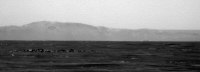
Wow, those triangular peaks to the south are really popping up too. Are they all part of Cape Tribulation?
Attached thumbnail(s)
-------------------- My website - My Patreon - @elakdawalla on Twitter - Please support unmannedspaceflight.com by donating here.
|
|
|
|
|
|
|
Jul 22 2011, 07:35 AM
Post
#997
|
|
 Senior Member Group: Moderator Posts: 2262 Joined: 9-February 04 From: Melbourne - Oz Member No.: 16 |
I haven't had the time to do a proper feature comparison (yet) but I would guess that those are part to the south-west rim quite a way beyond Cape Trib.
EDIT: Actually looking again, I'm inclined to change my mind. They probably are the very nearest peaks of the Cape Trib range that point toward Cape York. -------------------- |
|
|
|
| Guest_Sunspot_* |
Jul 22 2011, 07:41 AM
Post
#998
|
|
Guests |
QUOTE (Astro0 @ Jul 22 2011, 02:05 AM)  If those headings are correct then I think I'm ready to call....LAND HO!! Shouldn't it appear darker than that though? The further away features are, the lighter they appear because of the atmosphere. It looks lighter than the peaks around Cape Tribulation. |
|
|
|
|
Jul 22 2011, 08:12 AM
Post
#999
|
|
|
Senior Member Group: Moderator Posts: 4279 Joined: 19-April 05 From: .br at .es Member No.: 253 |
The colors are not absolute and may (and actually do) change from one image to another; remember that these are JPEGs where the brightness / contrast may be completely different from the original IMG pictures, so I would not compare the exact darkness of CY on that picture with CT on another one. If they were on the same pancam picture that would be a different story.
Besides, can you point a different feature on that (or similar) heading between CY and the far rim? There's no one.
|
|
|
|
|
Jul 22 2011, 08:31 AM
Post
#1000
|
||
 The Poet Dude Group: Moderator Posts: 5551 Joined: 15-March 04 From: Kendal, Cumbria, UK Member No.: 60 |
Overview...
Nope, nuttin obvious either between us and where CY should appear, or between CY and the far rim... there is a rise on the crater floor in that direction, but pretty sure it's not high enough to obscure the crater visible above what we're thinking is CY... -------------------- |
|
|
|
|
|
|
Jul 22 2011, 09:02 AM
Post
#1001
|
|
|
Senior Member Group: Moderator Posts: 4279 Joined: 19-April 05 From: .br at .es Member No.: 253 |
FWIW, there's another drive planned for today and, actually, Opportunity should be on the move right now. Let's see what the next batch of images show to us; there are no pancams on today's plan but maybe tomorrow.
|
|
|
|
| Guest_Sunspot_* |
Jul 22 2011, 10:04 AM
Post
#1002
|
|
Guests |
Do you know how far?
|
|
|
|
|
Jul 22 2011, 10:34 AM
Post
#1003
|
||
|
Senior Member Group: Moderator Posts: 4279 Joined: 19-April 05 From: .br at .es Member No.: 253 |
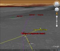
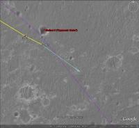
Not yet, but looking to the planned imaging sequences (see below) I think the plan includes a "mid-drive" navcam mosaic, probably of the little crater 90+ meters SE from the sol 2662 position, so I bet for a long 100+ meters drive.
02663::p0025::01::0::0::0::0::0::0::mer_b_sunfind_parms_left_eye_525_exp 02663::p0693::03::6::0::0::6::0::12::navcam_3x1_az_162_3_bpp <--- "post-drive" mosaic 02663::p1201::07::2::0::0::2::0::4::front_haz_penultimate_1bpp_pri17 02663::p1211::03::2::0::0::2::0::4::ultimate_front_haz_1_bpp_pri_15 02663::p1254::02::2::0::0::2::0::4::front_haz_fault_pri15_4bpp 02663::p1301::06::2::0::0::2::0::4::rear_haz_penultimate_1bpp_pri17 02663::p1312::07::2::0::0::2::0::4::rear_haz_ultimate_2_bpp_pri15 02663::p1354::01::2::0::0::2::0::4::rear_haz_fault_pri15_4bpp 02663::p1916::06::4::0::0::4::0::8::navcam_2x1_az_75_3_bpp <--- "mid-drive" mosaic? 02663::p2601::05::4::2::0::0::2::8::pancam_tau_L78R48 02663::p2627::02::36::0::0::0::0::36::pancam_sky_radiance_thumbs_L457R247
|
|
|
|
|
|
|
Jul 22 2011, 11:21 AM
Post
#1004
|
|
|
The Poet Dude Group: Moderator Posts: 5551 Joined: 15-March 04 From: Kendal, Cumbria, UK Member No.: 60 |
Why no pancams? I'd have thought they'd want as many as poss in the home run to CY.
Oh well, sure the navcams will be great!
-------------------- |
|
|
|
|
Jul 22 2011, 01:16 PM
Post
#1005
|
|
|
Solar System Cartographer Group: Members Posts: 10161 Joined: 5-April 05 From: Canada Member No.: 227 |
Emily: "Wow, those triangular peaks to the south are really popping up too. Are they all part of Cape Tribulation? "
James: " They probably are the very nearest peaks of the Cape Trib range that point toward Cape York. " If you check out Tesheiner's map in post 976 above, you can see that Solander Point (the smaller hills north of Cape Tribulation) must be directly in line with the Cape, in front of it. The hills appearing to the left are the more distant ones, where the rim curves eastwards. Phil -------------------- ... because the Solar System ain't gonna map itself.
Also to be found posting similar content on https://mastodon.social/@PhilStooke Maps for download (free PD: https://upload.wikimedia.org/wikipedia/comm...Cartography.pdf NOTE: everything created by me which I post on UMSF is considered to be in the public domain (NOT CC, public domain) |
|
|
|
|

|
Lo-Fi Version | Time is now: 14th May 2024 - 07:45 PM |
|
RULES AND GUIDELINES Please read the Forum Rules and Guidelines before posting. IMAGE COPYRIGHT |
OPINIONS AND MODERATION Opinions expressed on UnmannedSpaceflight.com are those of the individual posters and do not necessarily reflect the opinions of UnmannedSpaceflight.com or The Planetary Society. The all-volunteer UnmannedSpaceflight.com moderation team is wholly independent of The Planetary Society. The Planetary Society has no influence over decisions made by the UnmannedSpaceflight.com moderators. |
SUPPORT THE FORUM Unmannedspaceflight.com is funded by the Planetary Society. Please consider supporting our work and many other projects by donating to the Society or becoming a member. |
|