Cape Tribulation, Sol 3744 (6Aug'14) - Sol 4077 (15Jul'15) |

  |
Cape Tribulation, Sol 3744 (6Aug'14) - Sol 4077 (15Jul'15) |
 Aug 6 2014, 09:30 PM Aug 6 2014, 09:30 PM
Post
#1
|
||||
 Senior Member  Group: Moderator Posts: 2262 Joined: 9-February 04 From: Melbourne - Oz Member No.: 16 |
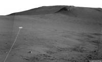
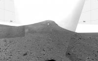
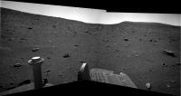
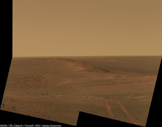
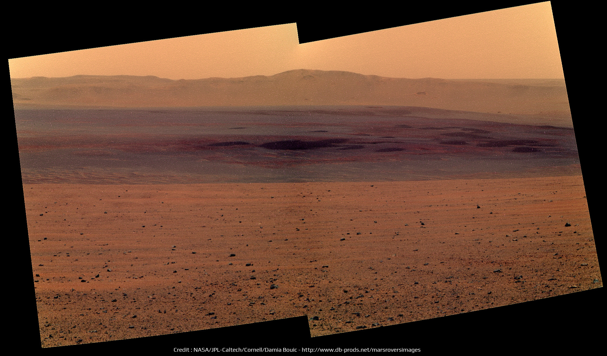
The ~85m drive on sol 3744 was uphill, starting the long climb of Cape Tribulation.
 The sol 3744 Drive:
Puts Opportunity about here on a plot with colour for elevation:
The view ahead:

-------------------- |
|||
 |
 
|
|||
|
Aug 6 2014, 10:29 PM
Post
#2
|
|||
|
Solar System Cartographer Group: Members Posts: 10162 Joined: 5-April 05 From: Canada Member No.: 227 |
Right! This is where I have it. (proper map update later)
Phil
-------------------- ... because the Solar System ain't gonna map itself.
Also to be found posting similar content on https://mastodon.social/@PhilStooke Maps for download (free PD: https://upload.wikimedia.org/wikipedia/comm...Cartography.pdf NOTE: everything created by me which I post on UMSF is considered to be in the public domain (NOT CC, public domain) |
||
|
|
|
||
|
Aug 9 2014, 03:29 PM
Post
#3
|
||
|
Solar System Cartographer Group: Members Posts: 10162 Joined: 5-April 05 From: Canada Member No.: 227 |
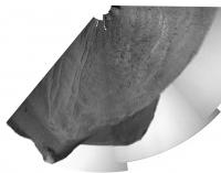
A circular view of a partial panorama from sol 3746.
Phil
-------------------- ... because the Solar System ain't gonna map itself.
Also to be found posting similar content on https://mastodon.social/@PhilStooke Maps for download (free PD: https://upload.wikimedia.org/wikipedia/comm...Cartography.pdf NOTE: everything created by me which I post on UMSF is considered to be in the public domain (NOT CC, public domain) |
|
|
|
|
|
|
Aug 9 2014, 11:18 PM
Post
#4
|
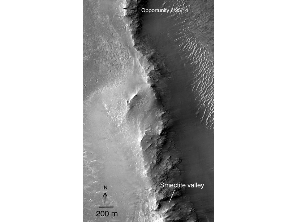
|
|
Member Group: Members Posts: 910 Joined: 4-September 06 From: Boston Member No.: 1102 |
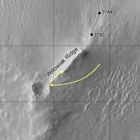
Do we know if Opportunity will be traveling east or west around Wdowiak Ridge [name corrected]?
-------------------- |
|
|
|
|
Aug 9 2014, 11:32 PM
Post
#5
|
|
|
Senior Member Group: Members Posts: 3516 Joined: 4-November 05 From: North Wales Member No.: 542 |
It won't be east. The slopes on the inside of the crater are too steep. I don't know if they want to visit that outcrop but if they do I'd expect they'd sneak up on it from the right (west) where the gradients are less severe
|
|
|
|
|
Aug 10 2014, 12:03 AM
Post
#6
|
|
|
Member Group: Members Posts: 910 Joined: 4-September 06 From: Boston Member No.: 1102 |
I'm not sure as the Eastern side is actually 200 m from the drop into the crater.
 -------------------- |
|
|
|
|
Aug 10 2014, 01:13 AM
Post
#7
|
|
 Senior Member Group: Members Posts: 4247 Joined: 17-January 05 Member No.: 152 |
I'd say the east side is doable. Remember this image in a recent Crumpler blog that has a dashed green line following the eastern ridgeline up and then turning west to get behind Cape Stevens. There was no description of that dashed line, but we've also heard that several options were being considered.
|
|
|
|
|
Aug 10 2014, 01:45 PM
Post
#8
|
||
|
Senior Member Group: Members Posts: 2830 Joined: 22-April 05 From: Ridderkerk, Netherlands Member No.: 353 |
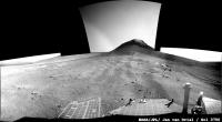
The Pancam L7 view on Sol 3746.
Jan van Driel
|
|
|
|
|
|
|
Aug 10 2014, 03:21 PM
Post
#9
|
|
|
Solar System Cartographer Group: Members Posts: 10162 Joined: 5-April 05 From: Canada Member No.: 227 |
OK... I was wrong. I saw the observation name cape Stevens and assumed it might be the rocky ridge south of us. Not so - it was a bit of outcrop near the rover. The big ridge is called Wdowiak Ridge. I will correct the map soon.
Phil -------------------- ... because the Solar System ain't gonna map itself.
Also to be found posting similar content on https://mastodon.social/@PhilStooke Maps for download (free PD: https://upload.wikimedia.org/wikipedia/comm...Cartography.pdf NOTE: everything created by me which I post on UMSF is considered to be in the public domain (NOT CC, public domain) |
|
|
|
|
Aug 11 2014, 03:10 PM
Post
#10
|
|
|
Senior Member Group: Members Posts: 3516 Joined: 4-November 05 From: North Wales Member No.: 542 |
What a picture!
http://qt.exploratorium.edu/mars/opportuni...__P1955L0M1.JPG |
|
|
|
|
Aug 11 2014, 03:35 PM
Post
#11
|
||
|
Senior Member Group: Members Posts: 4247 Joined: 17-January 05 Member No.: 152 |
Yeah!
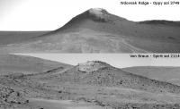
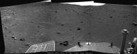
And with this last drive we've really climbed - we're getting back up towards the elevation of Broken Hills, as you can see from these hazcam views:
|
|
|
|
|
|
|
Aug 11 2014, 04:41 PM
Post
#12
|
||
|
Solar System Cartographer Group: Members Posts: 10162 Joined: 5-April 05 From: Canada Member No.: 227 |
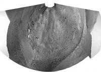
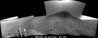
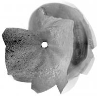
A quick circular view of sol 3749. The foreground features give a pretty good location.
Phil
-------------------- ... because the Solar System ain't gonna map itself.
Also to be found posting similar content on https://mastodon.social/@PhilStooke Maps for download (free PD: https://upload.wikimedia.org/wikipedia/comm...Cartography.pdf NOTE: everything created by me which I post on UMSF is considered to be in the public domain (NOT CC, public domain) |
|
|
|
|
|
|
Aug 11 2014, 06:10 PM
Post
#13
|
||
|
Senior Member Group: Members Posts: 2830 Joined: 22-April 05 From: Ridderkerk, Netherlands Member No.: 353 |
The Sol 3749 L0 Navcam view.
Jan van Driel
|
|
|
|
|
|
|
Aug 12 2014, 07:53 AM
Post
#14
|
||
|
Senior Member Group: Moderator Posts: 2262 Joined: 9-February 04 From: Melbourne - Oz Member No.: 16 |
Did anyone else get a feeling of deja-vu when seeing the navcams yesterday?

-------------------- |
|
|
|
|
|
|
Aug 12 2014, 12:59 PM
Post
#15
|
||
|
Senior Member Group: Moderator Posts: 2262 Joined: 9-February 04 From: Melbourne - Oz Member No.: 16 |
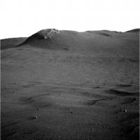
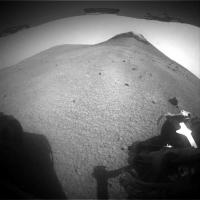
Closing in on Wdowiak Ridge!
Attached thumbnail(s)
-------------------- |
|
|
|
|
|
|
Aug 12 2014, 03:13 PM
Post
#16
|
||
|
Solar System Cartographer Group: Members Posts: 10162 Joined: 5-April 05 From: Canada Member No.: 227 |
A quick circular view of the sol 3750 images to help locate us.
Phil
-------------------- ... because the Solar System ain't gonna map itself.
Also to be found posting similar content on https://mastodon.social/@PhilStooke Maps for download (free PD: https://upload.wikimedia.org/wikipedia/comm...Cartography.pdf NOTE: everything created by me which I post on UMSF is considered to be in the public domain (NOT CC, public domain) |
|
|
|
|
|
|
Aug 12 2014, 07:14 PM
Post
#17
|
||
|
Senior Member Group: Members Posts: 2830 Joined: 22-April 05 From: Ridderkerk, Netherlands Member No.: 353 |
The Navcam panoramic view on Sol 3750.
Jan van Driel
|
|
|
|
|
|
|
Aug 12 2014, 08:55 PM
Post
#18
|
||
|
Member Group: Members Posts: 866 Joined: 15-March 05 From: Santa Cruz, CA Member No.: 196 |
QUOTE (ngunn @ Aug 11 2014, 07:10 AM)  What a picture! http://qt.exploratorium.edu/mars/opportuni...__P1955L0M1.JPG indeed that is a great view in crosseye too!
|
|
|
|
|
|
|
Aug 13 2014, 12:25 PM
Post
#19
|
||
 Senior Member Group: Moderator Posts: 3431 Joined: 11-August 04 From: USA Member No.: 98 |
Another drive on Sol 3751, and she's passing by.
Attached thumbnail(s)
|
|
|
|
|
|
|
Aug 13 2014, 01:18 PM
Post
#20
|
|
|
Senior Member Group: Members Posts: 2920 Joined: 14-February 06 From: Very close to the Pyrénées Mountains (France) Member No.: 682 |
Still possible to investigate from the top and less risky. We'll see.
-------------------- |
|
|
|
|
Aug 13 2014, 03:03 PM
Post
#21
|
|
|
Solar System Cartographer Group: Members Posts: 10162 Joined: 5-April 05 From: Canada Member No.: 227 |
That is what i would expect to see.
Phil -------------------- ... because the Solar System ain't gonna map itself.
Also to be found posting similar content on https://mastodon.social/@PhilStooke Maps for download (free PD: https://upload.wikimedia.org/wikipedia/comm...Cartography.pdf NOTE: everything created by me which I post on UMSF is considered to be in the public domain (NOT CC, public domain) |
|
|
|
|
Aug 13 2014, 03:13 PM
Post
#22
|
||
|
Senior Member Group: Members Posts: 2830 Joined: 22-April 05 From: Ridderkerk, Netherlands Member No.: 353 |
Sol 3750
Added 1 image. Jan van Driel
|
|
|
|
|
|
|
Aug 13 2014, 04:41 PM
Post
#23
|
|
|
Senior Member Group: Moderator Posts: 3431 Joined: 11-August 04 From: USA Member No.: 98 |
I didn't mean that she won't check out Wdowiak Ridge (I don't know); just that she's literally passing alongside the thing at the moment.
|
|
|
|
|
Aug 14 2014, 01:34 AM
Post
#24
|
||
|
Member Group: Members Posts: 866 Joined: 15-March 05 From: Santa Cruz, CA Member No.: 196 |
really pleasing sky exposure in these sol3751 pics, i can just relax in a beach chair with the cool radiation pleasantly peppering my molecules
heres a stitch with a little shadow fill for Wdowiak
|
|
|
|
|
|
|
Aug 14 2014, 07:29 AM
Post
#25
|
||
 Senior Member Group: Members Posts: 1088 Joined: 19-February 05 From: Close to Meudon Observatory in France Member No.: 172 |
QUOTE (climber @ Aug 13 2014, 03:18 PM) Still possible to investigate from the top and less risky. We'll see. A panoramic view would be gorgeous to see from the Wdowiak Ridge : if it cannot reach its summit, Oppy should rove at least a few tens of meters on it and/or take panoramic pictures from the rim of the crater standing at the beginning of the ridge itself (that may be also interesting to see on a scientific point of view for its geological layers). Spectacular views help us a lot doing our Mars EPO campaigns in France...
|
|
|
|
|
|
|
Aug 14 2014, 09:44 AM
Post
#26
|
||
|
Senior Member Group: Members Posts: 2830 Joined: 22-April 05 From: Ridderkerk, Netherlands Member No.: 353 |
The Navcam L0 view on Sol 3751.
Jan van Driel
|
|
|
|
|
|
|
Aug 14 2014, 02:07 PM
Post
#27
|
|
|
Senior Member Group: Members Posts: 4247 Joined: 17-January 05 Member No.: 152 |
Incredible view now looking back - we can see that we're higher than Solander Point/Murray Ridge now, and so at our highest point yet at Endeavour:
http://qt.exploratorium.edu/mars/opportuni...0M1.JPG?sol3752 A reminder of the early views we had of Wdowiak Ridge - I think this was the first ID of it: http://www.unmannedspaceflight.com/index.p...st&p=176029 |
|
|
|
|
Aug 14 2014, 06:51 PM
Post
#28
|
||
|
Senior Member Group: Members Posts: 2830 Joined: 22-April 05 From: Ridderkerk, Netherlands Member No.: 353 |
The Navcam panoramic view on Sol 3752.
Jan van Driel
|
|
|
|
|
|
|
Aug 14 2014, 07:09 PM
Post
#29
|
||
|
Senior Member Group: Members Posts: 2830 Joined: 22-April 05 From: Ridderkerk, Netherlands Member No.: 353 |
and another view on Sol 3752.
Jan van Driel
|
|
|
|
|
|
|
Aug 14 2014, 07:33 PM
Post
#30
|
||
|
Solar System Cartographer Group: Members Posts: 10162 Joined: 5-April 05 From: Canada Member No.: 227 |
Nice panoramas, as usual! Here is a circular projection.
Phil
-------------------- ... because the Solar System ain't gonna map itself.
Also to be found posting similar content on https://mastodon.social/@PhilStooke Maps for download (free PD: https://upload.wikimedia.org/wikipedia/comm...Cartography.pdf NOTE: everything created by me which I post on UMSF is considered to be in the public domain (NOT CC, public domain) |
|
|
|
|
|
|
Aug 14 2014, 08:41 PM
Post
#31
|
||
|
Member Group: Members Posts: 866 Joined: 15-March 05 From: Santa Cruz, CA Member No.: 196 |
Fredk, many thanks for the retrospectacle of early views of Solander, love seeing those..
nice look back sol3752 (perhaps this view even includes the spot where that photo was taken) and below in xeye, movin' on up!
|
|
|
|
|
|
|
Aug 15 2014, 01:18 PM
Post
#32
|
|
 Member Group: Members Posts: 810 Joined: 3-June 04 From: Brittany, France Member No.: 79 |
Wow, really nice crossed-eyes, thanks atomoid !
-------------------- |
|
|
|
|
Aug 15 2014, 08:14 PM
Post
#33
|
||
|
Senior Member Group: Members Posts: 2830 Joined: 22-April 05 From: Ridderkerk, Netherlands Member No.: 353 |
Sol 3752-3753
Added 2 images for the complete view. Jan van Driel
|
|
|
|
|
|
|
Aug 15 2014, 09:10 PM
Post
#34
|
|
|
Member Group: Members Posts: 866 Joined: 15-March 05 From: Santa Cruz, CA Member No.: 196 |
|
|
|
|
|
Aug 16 2014, 02:37 PM
Post
#35
|
|
|
Senior Member Group: Members Posts: 4247 Joined: 17-January 05 Member No.: 152 |
Some interesting information in the latest Crumpler blog.
The plan is to inspect the rocks that have come down the scree slope where we are now. After that there's a nice proposed route map taking us along the south side of Wdowiak to Ulysses crater and then on to Marathon valley. QUOTE We have two options: (1) take our time and pull into Marathon Valley just before winter shuts everything down, or (2) make rapid progress and arrive at Marathon Valley early enough in the season that we can do some sight-seeing before weather shuts things down. That's clearly being very conservative - this past winter certainly didn't shut us down!
|
|
|
|
|
Aug 16 2014, 03:35 PM
Post
#36
|
|
 Senior Member Group: Members Posts: 2173 Joined: 28-December 04 From: Florida, USA Member No.: 132 |
QUOTE (fredk @ Aug 16 2014, 10:37 AM) ...this past winter certainly didn't shut us down! Perhaps Marathon Valley itself will be off limits during the winter and that is what he is refering to. I really like those Crumpler posts! |
|
|
|
|
Aug 16 2014, 11:25 PM
Post
#37
|
|
|
Senior Member Group: Members Posts: 1044 Joined: 17-February 09 Member No.: 4605 |
Anyone have any information on the Marathon valley contours? I guess that they cannot assume that Marathon Valley and approaches will have the same superb cleaning environment as was the case last winter and Opportunity could well have a stationary mid winter sojourn as was the case on Cape York. Plan for the worst case and be pleasantly surprised if things are better. Couldn't agree more with respect to Larry Crumpler's blog.
|
|
|
|
|
Aug 18 2014, 04:32 PM
Post
#38
|
||
|
Senior Member Group: Members Posts: 4247 Joined: 17-January 05 Member No.: 152 |
The winter at CY was the only one out of six Oppy needed to hunker down, so even without the intense gusts we've had this winter there's good reason to be optimistic for next winter. But of course they must plan for the possibility.
Finally some new images - here's our first real closeup of the rock face in front of us:
|
|
|
|
|
|
|
Aug 18 2014, 05:10 PM
Post
#39
|
|
 Member Group: Members Posts: 691 Joined: 21-December 07 From: Clatskanie, Oregon Member No.: 3988 |
CODE 03756 11:59:36 189 164 469 p2380.34 4 pancam_Wdowiak_Ridge_pt1_4x1_L257R2 Looks like that image is for the first part of a color panorama. This shall be a scenic one!
|
|
|
|
|
Aug 19 2014, 09:09 PM
Post
#40
|
|
|
Senior Member Group: Members Posts: 4247 Joined: 17-January 05 Member No.: 152 |
The view keeps getting better and better!
 http://qt.exploratorium.edu/mars/opportuni...5M1.JPG?sol3754 http://qt.exploratorium.edu/mars/opportuni...5M1.JPG?sol3754 See how far you can follow our tracks back to Broken Hills... |
|
|
|
|
Aug 19 2014, 10:00 PM
Post
#41
|
|
|
Member Group: Members Posts: 910 Joined: 4-September 06 From: Boston Member No.: 1102 |
This is nice--fun to follow those tracks... Great images...
-------------------- |
|
|
|
|
Aug 19 2014, 10:46 PM
Post
#42
|
||
 Member Group: Members Posts: 404 Joined: 5-January 10 Member No.: 5161 |
QUOTE (fredk @ Aug 19 2014, 01:09 PM) The view keeps getting better and better! http://qt.exploratorium.edu/mars/opportuni...5M1.JPG?sol3754 http://qt.exploratorium.edu/mars/opportuni...5M1.JPG?sol3754 See how far you can follow our tracks back to Broken Hills... Really nice shots! Here's one in 3D from the NavCam a few sols earlier:
Looking forward to more shots from these heights. |
|
|
|
|
|
|
Aug 20 2014, 12:56 AM
Post
#43
|
||
 Senior Member Group: Admin Posts: 3108 Joined: 21-December 05 From: Canberra, Australia Member No.: 615 |
Making tracks - sol3754
|
|
|
|
|
|
|
Aug 20 2014, 01:37 AM
Post
#44
|
|
|
Member Group: Members Posts: 866 Joined: 15-March 05 From: Santa Cruz, CA Member No.: 196 |
Nice stitch, i've been waiting YEARS to see a view like this with an intervening mountain lower than the horizon. but thought we'd have to be higher up Cape Tribulation, pleasant surprise!
would be great to get a super-res of this overlaid with map tracks and SOLs all the way back to the location of Crumplers traverse map Cape York vanatage point. |
|
|
|
|
Aug 20 2014, 02:18 AM
Post
#45
|
|
|
Senior Member Group: Members Posts: 4247 Joined: 17-January 05 Member No.: 152 |
Thanks, Astro0! Stunning stitch - this is one of the best views of the mission.
Sketching our path would be very cool - not only would it extend to Cape York, but also back across the great Dune Sea, since we could see Wdowiak Ridge from quite a ways back. |
|
|
|
|
Aug 20 2014, 03:38 AM
Post
#46
|
|
|
Member Group: Members Posts: 691 Joined: 21-December 07 From: Clatskanie, Oregon Member No.: 3988 |
My take.
 And a false color to better show the tracks. 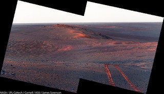
|
|
|
|
|
Aug 20 2014, 04:23 AM
Post
#47
|
|
|
Senior Member Group: Admin Posts: 3108 Joined: 21-December 05 From: Canberra, Australia Member No.: 615 |
We bow to your genius. Beautiful!
|
|
|
|
|
Aug 20 2014, 04:29 AM
Post
#48
|
|
|
Solar System Cartographer Group: Members Posts: 10162 Joined: 5-April 05 From: Canada Member No.: 227 |
I bow too.
Phil -------------------- ... because the Solar System ain't gonna map itself.
Also to be found posting similar content on https://mastodon.social/@PhilStooke Maps for download (free PD: https://upload.wikimedia.org/wikipedia/comm...Cartography.pdf NOTE: everything created by me which I post on UMSF is considered to be in the public domain (NOT CC, public domain) |
|
|
|
|
Aug 20 2014, 09:07 AM
Post
#49
|
|
|
Senior Member Group: Members Posts: 1088 Joined: 19-February 05 From: Close to Meudon Observatory in France Member No.: 172 |
QUOTE (James Sorenson @ Aug 20 2014, 05:38 AM) My take. Thanks so much James : how nice !
|
|
|
|
|
Aug 20 2014, 10:23 AM
Post
#50
|
|
 Senior Member Group: Members Posts: 1619 Joined: 12-February 06 From: Bergerac - FR Member No.: 678 |
Very good James
My take, in Poscard format 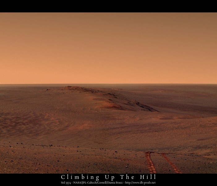
-------------------- |
|
|
|
|
Aug 20 2014, 02:27 PM
Post
#51
|
|
|
Member Group: Members Posts: 204 Joined: 14-April 06 From: Seattle, WA Member No.: 745 |
Oh, thank you Damia. I was looking forward to seeing a postcard. This will be a part of my next Mars presentation.
I can really imagine what it would be like to walk up this hill with Opportunity. What a ride!
|
|
|
|
|
Aug 20 2014, 02:33 PM
Post
#52
|
|
|
Member Group: Members Posts: 204 Joined: 14-April 06 From: Seattle, WA Member No.: 745 |
Oh, and let me also bow to James.
|
|
|
|
|
Aug 20 2014, 02:55 PM
Post
#53
|
|
|
Member Group: Members Posts: 691 Joined: 21-December 07 From: Clatskanie, Oregon Member No.: 3988 |
Damia, your's is now my new desktop background
. Great work, and thank you everyone. What a great place we are at.
|
|
|
|
|
Aug 21 2014, 06:40 AM
Post
#54
|
|||
|
Senior Member Group: Admin Posts: 3108 Joined: 21-December 05 From: Canberra, Australia Member No.: 615 |
So while we wait for much better colour views from James and Damia,
 here's a quick view across Endeavour Crater here's a quick view across Endeavour Crater Sort of freaks me out that view because I made a fanciful sketch of it over 4 years ago. Called it HOAV!
|
||
|
|
|
||
|
Aug 21 2014, 08:44 AM
Post
#55
|
|
|
Senior Member Group: Members Posts: 2920 Joined: 14-February 06 From: Very close to the Pyrénées Mountains (France) Member No.: 682 |
So, which one is the real one?
 I'm wondering how you'll call the view once we'll be a bit higher. HofHOAV? We definitely need a JAR emoticon.Thank you all for taking time to create those beautiful artistic pans I'm wondering how you'll call the view once we'll be a bit higher. HofHOAV? We definitely need a JAR emoticon.Thank you all for taking time to create those beautiful artistic pans
-------------------- |
|
|
|
|
Aug 21 2014, 09:16 AM
Post
#56
|
|
|
Senior Member Group: Members Posts: 1619 Joined: 12-February 06 From: Bergerac - FR Member No.: 678 |
As you wish
-------------------- |
|
|
|
|
Aug 21 2014, 11:01 AM
Post
#57
|
|
|
Member Group: Members Posts: 910 Joined: 4-September 06 From: Boston Member No.: 1102 |
James--any chance you have a wider version of the color elevation map for the region between Wdowiak Ridge and Smectite valley?
-------------------- |
|
|
|
|
Aug 21 2014, 05:12 PM
Post
#58
|
|
|
Member Group: Admin Posts: 976 Joined: 29-September 06 From: Pasadena, CA - USA Member No.: 1200 |
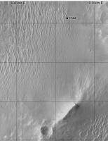
The DTM is publicly available:
http://www.uahirise.org/dtm/dtm.php?ID=ESP_018701_1775 in particular, here's the color coded altimetry: http://hirise-pds.lpl.arizona.edu/PDS/EXTR...1775_U01.ca.jpg Paolo -------------------- Disclaimer: all opinions, ideas and information included here are my own,and should not be intended to represent opinion or policy of my employer.
|
|
|
|
|
Aug 21 2014, 06:39 PM
Post
#59
|
|
|
Member Group: Members Posts: 910 Joined: 4-September 06 From: Boston Member No.: 1102 |
Thank you Paolo for pointing me to the links! Will Opportunity climb any higher than the brown elevation on its way to Smectite valley, or just follow the brown contour around. The ridge of the white peaks would have a great view...
-------------------- |
|
|
|
|
Aug 21 2014, 08:37 PM
Post
#60
|
|
|
Member Group: Members Posts: 691 Joined: 21-December 07 From: Clatskanie, Oregon Member No.: 3988 |
And the 1x2 mosaic looking East.

|
|
|
|
|
Aug 21 2014, 11:21 PM
Post
#61
|
|
|
Senior Member Group: Members Posts: 4247 Joined: 17-January 05 Member No.: 152 |
QUOTE (Floyd @ Aug 21 2014, 06:39 PM) Will Opportunity climb any higher than the brown elevation All we've heard is the proposed route map on Crumpler's blog. It shows the route climbing pretty much to the highest point ("summit lithology"). I seriously hope we make it there... 
|
|
|
|
|
Aug 22 2014, 12:32 PM
Post
#62
|
|
|
Senior Member Group: Members Posts: 1088 Joined: 19-February 05 From: Close to Meudon Observatory in France Member No.: 172 |
Totally agree with you Fredk.
People and EPO people like me would not understand if a 360° pan is not made from the very summit of Endeavour Crater's rim. This would mark a big step and will be seen as a major event in the history of the exploration of Mars !
|
|
|
|
|
Aug 27 2014, 02:03 PM
Post
#63
|
|
|
Senior Member Group: Members Posts: 4247 Joined: 17-January 05 Member No.: 152 |
It's now a week since we've received new pictures - the last were from 3758. It's not just that jpl/exploratorium aren't updating, since Lemmon's tau page also hasn't been updated since 3758.
We have been seeing previously unseen old images appear, though, which sounds like a good sign. |
|
|
|
|
Aug 27 2014, 02:10 PM
Post
#64
|
|
|
Solar System Cartographer Group: Members Posts: 10162 Joined: 5-April 05 From: Canada Member No.: 227 |
The JPL status report says there have been several flash memory faults in a row - typically these result from trying to write data to a bad area. Spirit went through this as well. The long-term fix is a reformatting, but that carries its own risks so it's only done when really necessary. That point might be approaching.
Phil -------------------- ... because the Solar System ain't gonna map itself.
Also to be found posting similar content on https://mastodon.social/@PhilStooke Maps for download (free PD: https://upload.wikimedia.org/wikipedia/comm...Cartography.pdf NOTE: everything created by me which I post on UMSF is considered to be in the public domain (NOT CC, public domain) |
|
|
|
|
Aug 27 2014, 04:29 PM
Post
#65
|
|
|
Member Group: Members Posts: 507 Joined: 10-September 08 Member No.: 4338 |
Is there risk in waiting too long to reformat flash? That is, could continuing flash anomalies prevent reformatting falsh? Or is the reformatting process itself independent of flash?
|
|
|
|
|
Aug 27 2014, 04:37 PM
Post
#66
|
|
|
Forum Contributor Group: Members Posts: 1372 Joined: 8-February 04 From: North East Florida, USA. Member No.: 11 |
QUOTE (marsophile @ Aug 27 2014, 04:29 PM) Or is the reformatting process itself independent of flash? The Rover also has 128 MB of DRAM, which is where the formatting program would run from, so it's independent. |
|
|
|
|
Aug 28 2014, 01:04 AM
Post
#67
|
|
 Member Group: Members Posts: 219 Joined: 14-November 11 From: Washington, DC Member No.: 6237 |
It is a ground problem, not a rover issue causing delay in images: https://twitter.com/nivnac/status/504757927954362368
|
|
|
|
|
Aug 28 2014, 02:31 AM
Post
#68
|
|
|
Senior Member Group: Members Posts: 4247 Joined: 17-January 05 Member No.: 152 |
I'm curious how James has learnt this - has the tracking database provided clues?
|
|
|
|
|
Aug 28 2014, 04:24 AM
Post
#69
|
||
|
Senior Member Group: Admin Posts: 3108 Joined: 21-December 05 From: Canberra, Australia Member No.: 615 |
I guess while we wait for news and images, here's a pan from Sol 3749 using images that appeared on Exploratorium in the last few days.
Uses both left and right hand pancam images, plus some artificial sky. |
|
|
|
|
|
|
Aug 28 2014, 07:53 AM
Post
#70
|
|
|
Senior Member Group: Moderator Posts: 2262 Joined: 9-February 04 From: Melbourne - Oz Member No.: 16 |
QUOTE (fredk @ Aug 28 2014, 03:31 AM) I'm curious how James has learnt this - has the tracking database provided clues? I don't know for sure. If I comment that there is no data on Twitter I get a bunch of worried replies, so i was really heading that off as there is no reason to be concerned. Circumstantial evidence that Oppy is OK: 1) We've seen data/images drop out many times before. 2) Recent comments on Twitter from insiders have sounded routine and unconcerned. 3) There are old images/data downlinked on recent sols. 4) New sequences are appearing in the tracking database (all be it just tau obs) 5) There are a bunch of 'Unexpected sequences' in the on board data list (which implies that the rover has sent data that the database had not been told about, i.e. ground data is missing, rover data fine) -------------------- |
|
|
|
|
Aug 29 2014, 09:04 PM
Post
#71
|
|
|
Founder Group: Chairman Posts: 14432 Joined: 8-February 04 Member No.: 1 |
QUOTE (Greenish @ Aug 27 2014, 05:04 PM) It is a ground problem, not a rover issue It's a rover issue. http://www.jpl.nasa.gov/news/news.php?release=2014-292 An increasing frequency of computer resets on NASA's Mars Exploration Rover Opportunity has prompted the rover team to make plans to reformat the rover's flash memory. The resets, including a dozen this month, interfere with the rover's planned science activities, even though recovery from each incident is completed within a day or two. |
|
|
|
|
Aug 29 2014, 10:40 PM
Post
#72
|
|
|
Member Group: Members Posts: 206 Joined: 15-August 07 From: Shrewsbury, Shropshire Member No.: 3233 |
When Spirit first landed its software crashed when its flash became more than 50% full. While this bug was being fixed, Spirit was switched to a mode where it did not use flash memory to store data. The picture in the link below was taken during this time:
http://mars.jpl.nasa.gov/mer/gallery/press.../20040128a.html This shows that Opportunity would be perfectly usable with flash memory disabled, although it would be able to do far less work each day. |
|
|
|
|
Aug 30 2014, 06:30 AM
Post
#73
|
|
 Member Group: Members Posts: 399 Joined: 28-August 07 From: San Francisco Member No.: 3511 |
With flash memory disabled, is driving possible?
I recall those tense Spirit flash days when Peter Theisinger was calming us all down...quite rightly... -------------------- 'She drove until the wheels fell off...'
|
|
|
|
|
Aug 30 2014, 09:19 AM
Post
#74
|
|
|
Member Group: Members Posts: 206 Joined: 15-August 07 From: Shrewsbury, Shropshire Member No.: 3233 |
QUOTE (eoincampbell @ Aug 30 2014, 06:30 AM) With flash memory disabled, is driving possible? I recall those tense Spirit flash days when Peter Theisinger was calming us all down...quite rightly... If command sequences are stored in different flash memory to that used to store data then I suppose that a 20m blind drive would be possible each day followed by each camera taking one picture at the end of the drive. These 8 pictures could then be transmitted to Earth at the end of the day's 20m drive without ever being stored in data flash memory. I imagine that it is also possible to instruct Opportunity to do something immediately over its direct Earth link without sending this instruction as part of a command sequence. It therefore might be possible to tell Opportunity to drive a few meters without making this command part of a sequence. |
|
|
|
|
Aug 30 2014, 10:23 AM
Post
#75
|
|
|
Senior Member Group: Members Posts: 2920 Joined: 14-February 06 From: Very close to the Pyrénées Mountains (France) Member No.: 682 |
I never heard that Spirit flash memory has been disabled, And I understand they are re formatting Oppy's not disabling
-------------------- |
|
|
|
|
Aug 30 2014, 10:38 AM
Post
#76
|
|
|
Member Group: Members Posts: 252 Joined: 27-April 05 Member No.: 365 |
QUOTE (climber @ Aug 30 2014, 04:23 AM) I never heard that Spirit flash memory has been disabled, And I understand they are re formatting Oppy's not disabling That was temporary: "While this bug was being fixed, Spirit was switched to a mode where it did not use flash memory to store data." |
|
|
|
|
Aug 30 2014, 01:15 PM
Post
#77
|
|
|
Member Group: Admin Posts: 976 Joined: 29-September 06 From: Pasadena, CA - USA Member No.: 1200 |
QUOTE (PaulM @ Aug 30 2014, 01:19 AM) If command sequences are stored in different flash memory to that used to store data then I suppose that a 20m blind drive would be possible each day followed by each camera taking one picture at the end of the drive. These 8 pictures could then be transmitted to Earth at the end of the day's 20m drive without ever being stored in data flash memory. I imagine that it is also possible to instruct Opportunity to do something immediately over its direct Earth link without sending this instruction as part of a command sequence. It therefore might be possible to tell Opportunity to drive a few meters without making this command part of a sequence. When the rover is in crippled mode we use part of the RAM as a file system and am not sure that the remaining RAM would support driving with the additional buffers we need for imaging and all that. And driving in real time? No way! The OWLT (One Way Light Time) varies from 5 to 20 minutes, communications take a LOT of power and takes time to switch between driving and communicating. We sometimes have very lengthy discussions on where to drive, how, what safety parameters to set. Just think yourself driving in a foreign country, no maps, with your mother-in-law providing "suggestions". How long would you last at the wheel? Paolo -------------------- Disclaimer: all opinions, ideas and information included here are my own,and should not be intended to represent opinion or policy of my employer.
|
|
|
|
|
Aug 30 2014, 03:15 PM
Post
#78
|
|
|
Member Group: Members Posts: 148 Joined: 9-August 11 From: Mason, TX Member No.: 6108 |
QUOTE (RoverDriver @ Aug 30 2014, 07:15 AM) Just think yourself driving in a foreign country, no maps, with your mother-in-law providing "suggestions". How long would you last at the wheel? You, sir, are a driver of great patience and a master of diplomacy.
-------------------- --
Don |
|
|
|
|
Sep 4 2014, 04:39 AM
Post
#79
|
|
|
Senior Member Group: Members Posts: 4247 Joined: 17-January 05 Member No.: 152 |
From the new PS update:
QUOTE The team will present its plan to a review board, scheduled for Wednesday, September 3rd, at JPL. If the plan passes the board's review general consensus is it will the reformatting could begin as early as the next day, September 4th, confirmed Callas. Let's hope for the best... |
|
|
|
|
Sep 5 2014, 01:56 PM
Post
#80
|
|
|
Solar System Cartographer Group: Members Posts: 10162 Joined: 5-April 05 From: Canada Member No.: 227 |
Just a thought... should we rename this place Cape Defibrillation?
Phil -------------------- ... because the Solar System ain't gonna map itself.
Also to be found posting similar content on https://mastodon.social/@PhilStooke Maps for download (free PD: https://upload.wikimedia.org/wikipedia/comm...Cartography.pdf NOTE: everything created by me which I post on UMSF is considered to be in the public domain (NOT CC, public domain) |
|
|
|
|
Sep 5 2014, 02:43 PM
Post
#81
|
|
|
Senior Member Group: Members Posts: 2920 Joined: 14-February 06 From: Very close to the Pyrénées Mountains (France) Member No.: 682 |
No no no, I'm sure they know how to do it... by heart
-------------------- |
|
|
|
|
Sep 5 2014, 03:33 PM
Post
#82
|
|
|
Member Group: Members Posts: 252 Joined: 27-April 05 Member No.: 365 |
I would image that after this procedure the formatting process will identify and mark off some bad sectors in the flash memory but is there any information yet on how many flash memory cells have already been marked as bad (both before launch, and as well since arriving at Mars). Also, how much got marked bad when Spirit did the procedure?
|
|
|
|
|
Sep 5 2014, 05:29 PM
Post
#83
|
|
|
Senior Member Group: Members Posts: 2920 Joined: 14-February 06 From: Very close to the Pyrénées Mountains (France) Member No.: 682 |
QUOTE (Burmese @ Sep 5 2014, 05:33 PM) Follow Fred's link... -------------------- |
|
|
|
|
Sep 5 2014, 08:18 PM
Post
#84
|
|
|
Member Group: Members Posts: 252 Joined: 27-April 05 Member No.: 365 |
Ok, so Spirit lost 7% of total flash capacity when it reformatted, amounting to about 1/2 a bank. Worst case for Oppy could be about double that if they have to stop accessing bank 7 altogether.
|
|
|
|
|
Sep 5 2014, 10:09 PM
Post
#85
|
|
|
Senior Member Group: Members Posts: 2346 Joined: 7-December 12 Member No.: 6780 |
If I understood the article correctly, the flash memory consists of 8 banks, each bank of 4 packages, each package of 32 sectors of 64 kBytes. The finest granularity for marking as bad is a sector. Total number of sectors is 8 * 4 * 32 = 1024. Hence the memory is marked in 1/1024 steps as bad.
The actual number of bad sectors of these 1024 sectors is known after reformatting. One bank (128 sectors) is excluded from the reformatting, since it contains the operating system, and is not exposed to frequent rewriting cycles. Whether the reformatting resolves the root cause of the reboots, is known afterwards, too. |
|
|
|
|
Sep 7 2014, 07:57 AM
Post
#86
|
||
|
Senior Member Group: Admin Posts: 3108 Joined: 21-December 05 From: Canberra, Australia Member No.: 615 |
Today on Mars
Sol 3775 - Navcam
NB: Two LH images with partial RH image stitched in to cover a data drop. Artificial sky added for effect.
|
|
|
|
|
|
|
Sep 7 2014, 08:58 AM
Post
#87
|
||||
|
Senior Member Group: Admin Posts: 3108 Joined: 21-December 05 From: Canberra, Australia Member No.: 615 |
A few more quick stitches.
Pancam
Navcam
Wider pan of the post above using RH Navcams but with the drop-out image from the LH Navcam, so the reason for the mismatch.
|
|||
|
|
|
|||
|
Sep 7 2014, 08:49 PM
Post
#88
|
|
|
Member Group: Members Posts: 691 Joined: 21-December 07 From: Clatskanie, Oregon Member No.: 3988 |
QUOTE (Astro0 @ Sep 7 2014, 12:57 AM) Today on Mars Sol 3775 - Navcam Great work! And my take to. 
|
|
|
|
|
Sep 8 2014, 09:59 AM
Post
#89
|
||
|
Senior Member Group: Members Posts: 2830 Joined: 22-April 05 From: Ridderkerk, Netherlands Member No.: 353 |
Here is the complete Navcam panoramic view on Sol 3775.
Jan van Driel
|
|
|
|
|
|
|
Sep 8 2014, 09:32 PM
Post
#90
|
|||
|
Member Group: Members Posts: 866 Joined: 15-March 05 From: Santa Cruz, CA Member No.: 196 |
thanks for the great stitches! its great to be Oppy-rational again. greats sights on sol3775 from the parting view going up around the bend and look up to Wdowiak with Klingon face etched atop the rock garden variety slab.
|
||
|
|
|
||
|
Sep 8 2014, 09:54 PM
Post
#91
|
|
|
Member Group: Members Posts: 910 Joined: 4-September 06 From: Boston Member No.: 1102 |
So can anyone give us an updated on the flash reformatting? Images are arriving, but from where in the pipeline? I'm assuming all went well.
-------------------- |
|
|
|
|
Sep 8 2014, 10:30 PM
Post
#92
|
|
|
Senior Member Group: Members Posts: 3516 Joined: 4-November 05 From: North Wales Member No.: 542 |
QUOTE (Floyd @ Sep 8 2014, 10:54 PM) I'm assuming all went well. Me too. These are new post-format images as Astro0's celebratory post implies . Only time will tell if the problems are completely fixed, though.
|
|
|
|
|
Sep 9 2014, 12:12 AM
Post
#93
|
|
|
Senior Member Group: Members Posts: 4247 Joined: 17-January 05 Member No.: 152 |
QUOTE (ngunn @ Sep 8 2014, 10:30 PM) post-format images We heard that the formatting was probably going to go ahead last week but I haven't heard if it actually went ahead... |
|
|
|
|
Sep 9 2014, 12:14 AM
Post
#94
|
|
 Senior Member Group: Members Posts: 2428 Joined: 30-January 13 From: Penang, Malaysia. Member No.: 6853 |
QUOTE (fredk @ Sep 9 2014, 08:12 AM) We heard that the formatting was probably going to go ahead last week but I haven't heard if it actually went ahead... NASA's Mars Exploration Rover Opportunity has successfully reformatted its flash memory. Telemetry downlinked from Mars' most seasoned rover indicates the reformat completed successfully on Sol 3773 (Thursday 2014-09-04). LINK to full report : http://www.jpl.nasa.gov/news/news.php?release=2014-292 |
|
|
|
|
Sep 9 2014, 01:37 AM
Post
#95
|
|
|
Senior Member Group: Members Posts: 4247 Joined: 17-January 05 Member No.: 152 |
Thanks for pointing that out - I never thought to look for an update in the old press release!
|
|
|
|
|
Sep 10 2014, 08:07 AM
Post
#96
|
||
|
Senior Member Group: Members Posts: 2830 Joined: 22-April 05 From: Ridderkerk, Netherlands Member No.: 353 |
The Navcam L0 view on Sol 3778.
Jan van Driel
|
|
|
|
|
|
|
Sep 10 2014, 11:28 AM
Post
#97
|
||
|
Senior Member Group: Admin Posts: 3108 Joined: 21-December 05 From: Canberra, Australia Member No.: 615 |
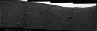
Land of the Long Shadows
|
|
|
|
|
|
|
Sep 10 2014, 04:20 PM
Post
#98
|
||
|
Solar System Cartographer Group: Members Posts: 10162 Joined: 5-April 05 From: Canada Member No.: 227 |
This is a circular view of Jan's full panorama from sol 3775. Opportunity shows Rosetta how to land on a double-lobed object. Simples!
Phil
-------------------- ... because the Solar System ain't gonna map itself.
Also to be found posting similar content on https://mastodon.social/@PhilStooke Maps for download (free PD: https://upload.wikimedia.org/wikipedia/comm...Cartography.pdf NOTE: everything created by me which I post on UMSF is considered to be in the public domain (NOT CC, public domain) |
|
|
|
|
|
|
Sep 10 2014, 08:10 PM
Post
#99
|
|
|
Member Group: Members Posts: 866 Joined: 15-March 05 From: Santa Cruz, CA Member No.: 196 |
|
|
|
|
|
Sep 11 2014, 09:33 AM
Post
#100
|
||
|
Senior Member Group: Members Posts: 2830 Joined: 22-April 05 From: Ridderkerk, Netherlands Member No.: 353 |
The L7 Pancam view on Sol 3778
Jan van Driel
|
|
|
|
|
|
|

|
Lo-Fi Version | Time is now: 16th May 2024 - 04:30 PM |
|
RULES AND GUIDELINES Please read the Forum Rules and Guidelines before posting. IMAGE COPYRIGHT |
OPINIONS AND MODERATION Opinions expressed on UnmannedSpaceflight.com are those of the individual posters and do not necessarily reflect the opinions of UnmannedSpaceflight.com or The Planetary Society. The all-volunteer UnmannedSpaceflight.com moderation team is wholly independent of The Planetary Society. The Planetary Society has no influence over decisions made by the UnmannedSpaceflight.com moderators. |
SUPPORT THE FORUM Unmannedspaceflight.com is funded by the Planetary Society. Please consider supporting our work and many other projects by donating to the Society or becoming a member. |
|