Printable Version of Topic
Click here to view this topic in its original format
Unmanned Spaceflight.com _ Perseverance- Mars 2020 Rover _ South from the landing site, sols 72-237
Posted by: Phil Stooke May 3 2021, 11:35 PM
It's not easy to figure out where to divide threads, but we just had a drive on sol 72 which I think we could say signifies the beginning of the traverse to the south and the start of regular science operations. Originally I expected a clean break with helicopter operations but we are not getting such an obvious dividing point.
So I am taking it on myself to start a new thread for the exploration mission. If the timing seems wrong people can let me know.
Phil
Posted by: Phil Stooke May 4 2021, 12:15 AM
This is the new location after the sol 72 drive. Map update follows!
Phil
|
Posted by: James Sorenson May 4 2021, 05:11 AM
Here is my version for the Sol-72 Post-drive panorama. I kind of went your way Phil in projecting the polar, or what you say is called 'Circular'. Let me know if you want me to do these in the future over the previous polar projection that I used.
https://flic.kr/p/2kWyZnz
https://flic.kr/p/2kWBNgG
Posted by: Phil Stooke May 4 2021, 06:25 AM
That's very nice, James. If you feel like doing that I would be happy to see it.
It looks to me like there is a nice path to the SSW from here to a smooth area which would be the next helicopter landing zone.
Phil
Posted by: xflare May 4 2021, 08:33 AM

So I am taking it on myself to start a new thread for the exploration mission. If the timing seems wrong people can let me know.
Phil
I think by SOL would be best :
Sol 0 - 100
Sol 101 - 200
etc
Posted by: nprev May 4 2021, 08:47 AM
Good call, Phil. The shift to a new phase of the journey has definitely happened.
Onward!
Posted by: fredk May 4 2021, 01:47 PM
Phobos (I think) imaged by skycam twice a few minutes apart overnight on sol 73:
https://mars.nasa.gov/mars2020-raw-images/pub/ods/surface/sol/00073/ids/edr/browse/meda/WSM_0073_0673379021_000ECM_N0032346MEDA03445_0000LUJ01.png
https://mars.nasa.gov/mars2020-raw-images/pub/ods/surface/sol/00073/ids/edr/browse/meda/WSM_0073_0673379207_000ECM_N0032346MEDA03445_0000LUJ01.png
Posted by: fredk May 4 2021, 07:09 PM
No sign of any skyglow in those images - the ND mask should make that easy if it was there. Insight ICC, which is optically identical to skycam, was able to see some skyglow at night back at http://www.unmannedspaceflight.com/index.php?showtopic=8432&st=780&p=246294&#entry246294 which we speculated was due to Phobos-shine. Perhaps it's just a matter of exposure time.
ICC also http://www.unmannedspaceflight.com/index.php?showtopic=8432&st=720&p=245855&#entry245855 on several occasions, so skycam should be able to too, and the https://www.hou.usra.edu/meetings/lpsc2020/pdf/2282.pdf was to measure stellar fluxes at night.
Posted by: PaulH51 May 4 2021, 11:38 PM
Another drive on sol 73, looks to be SSE
|
Posted by: Andreas Plesch May 4 2021, 11:46 PM
Two large boulders, cracked vertically on sol 73, next to each other. Coincidence ? Perhaps the same material, and similar shape, responding to thermal stresses ? With a preexisting weakness in similarly oriented planes ?
|
https://mars.nasa.gov/mars2020-raw-images/pub/ods/surface/sol/00073/ids/edr/browse/ncam/NLF_0073_0673426662_691ECM_N0032394NCAM00301_01_295J01.png
https://mars.nasa.gov/mars2020-raw-images/pub/ods/surface/sol/00073/ids/edr/browse/fcam/FLF_0073_0673429272_074ECM_N0032430FHAZ02008_13_195J01.png
Posted by: James Sorenson May 5 2021, 03:29 AM
The Sol-73 Post-drive Navcam pan's. I'm now aligning the circular/polar image to North-top which I'm using the terrific Marslife.org website to quickly determine that. I'm not aligning the regular panorama yet. 
https://flic.kr/p/2kWHD1T
Circular/Polar
https://flic.kr/p/2kWEgmx
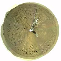
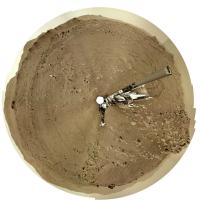
Posted by: Phil Stooke May 5 2021, 03:55 AM
Thanks, James, very useful. Looking for new science targets or looking for a path to the south? I wish we were getting more reports on activity, as we do with Curiosity. Maybe later...
Phil
Posted by: James Sorenson May 5 2021, 05:53 AM
My attempt at the Sol-73 Navcam sky pan. There was some lovely clouds visible in the raws, I might have butchered the heck out of them during blending.
Ah well, I tried...
Looking forward to Damia's version. Her last one was cleaner.
https://flic.kr/p/2kWKFKP
Posted by: Ant103 May 5 2021, 07:35 AM
Yes, hard pictures.
Her.
My version of this spectacular panoramic
https://db-prods.net/marsroversimages/Perseverance/2021/Sol73_pano.jpg
Postcard maybe ?
https://www.db-prods.net/blog/2021/05/05/cloudy-sunset/
Posted by: ngunn May 5 2021, 11:36 AM
It's wonderful to see a full sky colour panorama from Mars. Congratulations to all concerned. It would be great for projecting on a planetarium (or other) dome.
Posted by: James Sorenson May 5 2021, 03:17 PM
My apologies, Damia.
Posted by: alan May 5 2021, 06:34 PM
Have they announced that they have chosen the southern route rather than the north route?
Posted by: Phil Stooke May 5 2021, 08:40 PM
Yes, in a press conference a few days ago.
Phil
Posted by: centsworth_II May 5 2021, 10:08 PM
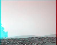
The discussion of the route south starts at 28:30 of the video: https://www.youtube.com/watch?v=BAlXe-U0ws4
Here is a screen shot. I added the 1 mile long bar. The length of the red-marked zone was said to be a little more than a mile. Also stated was that the science campaign in this area, including sample collection, would last several hundred sols. So a year or more before the rover heads toward the delta.

|
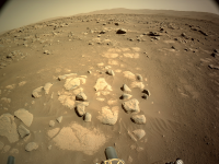
Posted by: MahFL May 6 2021, 05:02 AM
Here is a screen shot. I added the 1 mile long bar. The length of the red-marked zone was said to be a little more than a mile. Also stated was that the science campaign in this area, including sample collection, would last several hundred sols. So a year or more before the rover heads toward the delta.
That kind of implies a much longer mission is anticipated than 2 Earth years.
Posted by: centsworth_II May 6 2021, 07:53 AM
Posted by: Andreas Plesch May 6 2021, 09:46 PM
Sol 74 saw a large 116 image mosaic of the local rock assembly by MCZ. The great Marslife.org does a great job of merging, and I took the liberty to post the result here for quick reference to help locate individual frames from the raw images which is otherwise quite difficult:
https://captainvideo.nl/marslife/index.html
I hope that is ok. It may be one of the largest outcrop mosaics for Perseverance sofar, so perhaps this patch will be studied in some detail ?
Posted by: Andreas Plesch May 6 2021, 10:11 PM
I do think it is a good idea to spend extended time out here since two years seemed very conservative, and chances are that once the rover leaves the area it will never come back. The location is very interesting due to a quieter depositional environment in the possibly shallow lake, proximity to a contact between mappable geological units, and the early observations of a diversity of rock types.
There are also groups which are very interested to visit the area just west outside of the crater which was scheduled for the second year, I believe. So it will be interesting to see if the several hundred days here in the outer delta, lake bottom area, will affect the time available at the actual delta remnants. I cannot really imagine it would but perhaps some kind of agreement between groups was necessary.
Posted by: PaulH51 May 7 2021, 04:48 AM
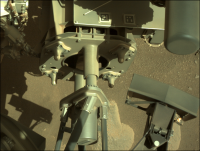
Hardware check-out on sol 75
WATSON image

|
Posted by: neo56 May 7 2021, 07:08 AM
Nice piece of hardware! This is a part of the sampling and caching system I guess? The entry of the carousel?
Posted by: PaulH51 May 7 2021, 09:46 AM
It appears so
Posted by: PaulH51 May 7 2021, 02:39 PM
Another engineering checkout?
This time close to midnight using the white LED banks on WATSON? Imaging the external interface of the 'Bit carousel.
Note the raw image page for these images does not provide the focus count or which LED banks were on / off like we get on MSL. That will probably have to wait until they set up formal JSON pages as the image pipeline matures?

|
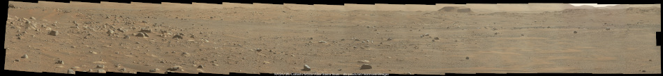
Posted by: Ant103 May 9 2021, 10:48 AM
Sol 77, an other all-sky panoramic. This time at midsol.
https://db-prods.net/marsroversimages/Perseverance/2021/Sol77_pano.jpg
Posted by: phase4 May 9 2021, 11:24 AM
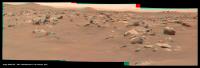
Supercam laser scratches the surface? Sol 74/75.

|
Posted by: neo56 May 9 2021, 08:16 PM
Nice work Damia! Here is my version. That's not easy to stitch the zenith picture without evident control points.
Your vignetting correction is really good, I've still adjustements to provide.
https://flic.kr/p/2kXvLPx
https://flic.kr/p/2kXvUtL
Posted by: vikingmars May 10 2021, 04:23 PM
When the Ingenuity helicopter made its 5th flight last Friday, two faint dust devils were recorded in the same field of view !
They were located well behind Ingenuity. Enjoy

|
Posted by: Andreas Plesch May 11 2021, 04:53 AM
ZCAM has captured on sol 78 what looks like the most holey rock sofar:
https://mars.nasa.gov/mars2020/multimedia/raw-images/ZR0_0078_0673871108_053ECM_N0032430ZCAM08041_110085J

|
Posted by: charborob May 11 2021, 01:40 PM
Sol 78 LMastcam-Z panorama:
|
|
Posted by: vikingmars May 12 2021, 10:30 AM
The MastCam-Z panorama taken Sol 78 is gorgeous.
Here is a section processed in 3D.
Look at all those rolling ridges with rocks perched on top of sand dunes.
This is the very romantic view of Mars "a la Bradbury " we all love to see!
What a great camera the MastCam-Z is !
=>> I hope, they will soon take a similar panoramic picture, but at sunrise and/or at sunset with looooooong shadows which makes the landscape even more beautiful and the relief come out even better 
CONGRATULATIONS to the MastCam-Z team
Enjoy

|
|
Posted by: vikingmars May 12 2021, 05:15 PM
Congratulations Thomas for this nice work of yours

Posted by: PaulH51 May 13 2021, 06:32 AM
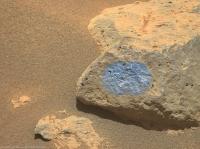
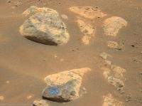
I'm assuming that this was a 'characterization test' of the rover's arm at a 'teach-point' in front of the rover, with what appears very similar to the canned bricks of organic check material carried by Curiosity (but sadly not used so far)
If that assumption is correct I guess they could puncture the can and return a sample to earth in a sealed sample tube to ensure there were no earthly organics in it as a cross check, if so it could be the first sample acquired / cached?
Or it could be like MSL, only to be used in the event PIXL detects organics?
Does anyone know if either of those assumption are correct?
Google search using organic check material etc has failed to provide an answer for this rover.
|
Posted by: vikingmars May 13 2021, 08:36 AM
Larger panorama to show the above section in a larger context 3D. Enjoy
|
|
Posted by: neo56 May 14 2021, 10:01 AM
Nice anaglyph Olivier!
Here is a photomontage of SuperCam/RMI and MCZ-L pictures taken on sol 80.
https://flic.kr/p/2kYuMxp
Posted by: erwan May 15 2021, 05:31 PM
sherloc context imager return some curious pictures of a somewhat textured stone, like a fabric, see sol 83
|
|
Posted by: Deimos May 15 2021, 05:36 PM
I don't see it https://mars.nasa.gov/mars2020/multimedia/raw-images/SC3_0083_0674309226_660ECM_N0032430SRLC11320_0000LUJ. Maybe something happened.
Posted by: djellison May 15 2021, 05:53 PM
It's just possible something happened....
https://www.hou.usra.edu/meetings/lpsc2017/pdf/2839.pdf
"Survey mode. Initial observations will be performed on an abraded patch in survey mode. The laser will fire raster over a 7x7 mm area with 200μm spacing to gen- erate 1225 spectra arranged in a 35x35 point grid. A Raman/fluorescence spectrum is acquired within 1 sec at each point. These spectra can be averaged together to get bulk organic/mineral abundances over the entire scanned area."
Posted by: erwan May 15 2021, 06:01 PM
Thank you Deimos, you are right. Maybe some turret's hardware foot print ? (from sherloc ACI itself ? ; by the way, I presume we see three laser holes on the right of larges pictures).
Posted by: erwan May 15 2021, 06:11 PM
https://www.hou.usra.edu/meetings/lpsc2017/pdf/2839.pdf
"Survey mode. Initial observations will be performed on an abraded patch in survey mode. The laser will fire raster over a 7x7 mm area with 200μm spacing to gen- erate 1225 spectra arranged in a 35x35 point grid. A Raman/fluorescence spectrum is acquired within 1 sec at each point. These spectra can be averaged together to get bulk organic/mineral abundances over the entire scanned area."
A 35 x 35 point grid ! Doug thank you. that is certainly the 'fabric', and on the right it's probably 3 laser holes from chemcam...
Posted by: PaulH51 May 16 2021, 05:48 AM
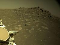
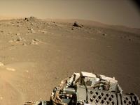
Sol 84: L-NavCam looking back after a short drive (West) to site number 4
|
Edit (drive direction corrected, thanks Phil)
Posted by: vikingmars May 16 2021, 06:40 AM
Sol 82 early morning MastCam-Z pictures in 3D.
I wish that a sunrise or a sunset panorama will be taken soon in color and in 3D : this would be gorgeous to see !
|
Posted by: vikingmars May 16 2021, 07:03 AM
I like very much those 'sky dynamics' pictures taken early morning. Enjoy !

|
Posted by: Phil Stooke May 16 2021, 07:18 AM
This is the partial pan from sol 84 which gave me the location for the map.
Phil

|
Posted by: James Sorenson May 16 2021, 08:07 AM
I'm awaiting all of the Navcam images to come down for the latest drive for the 360. While waiting, I assembled the binned 2x2 tiled mosaic looking over the deck-to the horizon from Sol-84.
https://flic.kr/p/2kYRcgg
Posted by: PaulH51 May 16 2021, 08:08 AM
Sol 82 Hazcam animation of drill stabilization test (push-up)

|
Posted by: tau May 16 2021, 03:24 PM
Colorful multispectral Mars on Sol 77
A
B

C


A) Mastcam-Z left eye, filter 0, original RGB
B) Mastcam-Z left eye, filter 0 (RGB channels) and filters 1 to 6 converted to RGB using principal component analysis and color space transformation.
The sky was excluded from the principal component calculation, but the resulting coefficients were applied to it, too (no manual coloring).
C) Mastcam-Z right eye, infrared filters 1 to 6, without filter 0.
Because of the only slight differences in the infrared reflectances of the Martian landscape, the calculated principal components are strongly influenced by inhomogeneities in the filter flat fields, slight pixel shifts (less than one pixel), and probably chromatic aberration. Only the first and second components were used here. The unique blue color of the cliff face and rock fragments on the talus below the cliff in this image suggests a mineralogical composition distinct from that of the dunes and boulders in the foreground and the crater wall in the background.
Posted by: neo56 May 16 2021, 04:54 PM
Very interesting work! It reminds me PCA I used to do during my PhD thesis when I was working on martian seasonal ices. We did PCA on OMEGA hyperspectral images to identify different kinds of mixing between CO2 ice, H2O ice and dust.
Posted by: James Sorenson May 17 2021, 06:56 PM
The Sol-84 post-drive Navcam pan.
https://flic.kr/p/2kZarVq
Polar
https://flic.kr/p/2kZ2UHH
Posted by: PaulH51 May 18 2021, 01:59 PM
Drive on sol 86 (Site 4, Drive 0048) end-of-drive FL-Hazcam

|
Posted by: Phil Stooke May 19 2021, 03:51 AM
A circular panorama from sol 86.
Phil

|
Posted by: James Sorenson May 19 2021, 06:23 AM
The post-drive Navcam pan from Sol-86.
https://flic.kr/p/2kZtn5Z
Polar
https://flic.kr/p/2kZrR4s
Posted by: PaulH51 May 19 2021, 11:34 AM
Engineering Check-out, or bit exchange?
Sol 87 Navcam's

|
Posted by: tau May 19 2021, 01:00 PM
Sol 87 Mastcam-Z filter 0 slightly processed and combined to 3D

|

|
Posted by: James Sorenson May 19 2021, 11:52 PM
A 3D model of the large rock that is now in-front of the rover. This is using the Sol-87 images. I had to reduce the resolution of the model for upload to SketchFab. Hopefully Perseverance can drive around to the opposite side of it to image it so i can fill in some of the large holes with real data.
Anyone know what the name of this rock is?
https://sketchfab.com/3d-models/perseverance-sol-87-mastcam-z-large-rock-57d1e821181046d38cd9d572823ee334?fbclid=IwAR3T1J03oEC8fOcsSOPFcnwM4KL3XtnbiJLbLCGQBbzTsnCuV3CP_MizXOA
Posted by: Phil Stooke May 20 2021, 02:39 AM
"Anyone know what the name of this rock is?"
Sorry, James - no. I wish we had more target names. The first data will show up in PDS in August and if the Analyst's notebook is available then a whole lot of names will probably show up. There will be some re-mapping going on with those names attached.
Phil
Posted by: Steve5304 May 21 2021, 02:43 AM
Is this damage?
sol 82 hazcam btw
Posted by: PaulH51 May 21 2021, 02:52 PM
sol 82 hazcam btw
I think that may not be damage, it looks like it's the 'SLI' (single layer insulation) which is part of the gDRT system. It's purpose is described in this PDF as a blanket of insulation covered in black Kapton tape https://ttu-ir.tdl.org/bitstream/handle/2346/84462/ICES-2019-249.pdf?sequence=1&isAllowed=n, there are some sketches etc in the PDF but they're not that detailed. However, I've not managed to find an image of it before launch.
Posted by: PDP8E May 21 2021, 10:00 PM
ohhh MEDA SkyCam!
I have looked at all your images -- and have not discerned a single cloud! (probably my skills)
But, I have seen a few nighttime moon pictures and those night shots are helping me to identify persistent HOT pixels to subtract from future astrophotography.
Is there a known cloudy season/time here?
After going in "circles", this is the only thing I have... sorry...

|
Posted by: Steve5304 May 21 2021, 10:50 PM
Oh its an odd looking fabrication...the angle is nuts...tonight I'm gong to look through older images to see if i can find more. I would just be curious if it *was* damage...literally how did it happen
Posted by: mcaplinger May 21 2021, 11:30 PM
https://mars.nasa.gov/resources/22700/attaching-mars-2020s-turret/?site=msl
Posted by: Ant103 May 22 2021, 10:33 AM
Sol 89, a very nice MastcamZ panoramic !
https://db-prods.net/marsroversimages/perseverance2021.php#21
Posted by: vikingmars May 22 2021, 05:16 PM
=>> Here is the Sol 89 pan in its 3D version : a gorgeous perspective indeed ! Enjoy
|
|
Posted by: tau May 23 2021, 04:00 PM
At least two laser shots on sol 91.
A
B

C


A) Stitched SuperCam photo with laser holes (green crosses).
B) Context photo from Mastcam-Z left eye, filter 0, slightly enhanced, with outline of image A.
C) Multispectral image, Mastcam-Z left eye, filters 0 to 6, principal components 1, 3, and 2, with outline of image A.
Posted by: James Sorenson May 24 2021, 01:15 AM
The post-drive Sol-91 Navcam panorama's.
https://flic.kr/p/2m1cytt
Polar
https://flic.kr/p/2m1kbxR
Posted by: PaulH51 May 24 2021, 09:59 AM
Sol 91: left side Mastcam-Z, Arm-workspace mosaic (zoom set at 34mm)
Roughly assembled in MS-ICE, with added 50 cm scalebar.

|
Posted by: tau May 24 2021, 08:47 PM
SuperCam sighted a layered outcrop on sol 92.
A
B

C


A) Layered outcrop of the lower etched unit as seen by SuperCam
B) The same as seen in the distance by Mastcam-Z on sol 89
C) Location of the outcrop about 550 m southwest from Perseverance
Edit: Wrong position of the outcrop seen by SuperCam in image C (about 100 m off). Correction of the error in my next post.
Posted by: vikingmars May 25 2021, 08:34 AM
Roughly assembled in MS-ICE, with added 50 cm scalebar.
Thanks to you, PaulH51, we can see the rocks up-close.
Now, you can grab them !

|
Posted by: PaulH51 May 25 2021, 09:18 AM
Nice Anaglyph
I'll have the one closest to the rover
Posted by: HSchirmer May 25 2021, 10:31 AM
Quick question - what is the usable range of the sampling laser?
Kinda curious whether nuclear powered lasers on the rover could take a sample at distance, then send the chopper over to see what material lies beneath the 'desert varnish'.
Posted by: djellison May 25 2021, 01:16 PM
7m per https://www.hou.usra.edu/meetings/lpsc2016/pdf/1322.pdf
Posted by: Phil Stooke May 25 2021, 02:38 PM
You also got a nice glimpse of Ingenuity, about 70% of the way from left to right.
Phil
Posted by: Steve G May 25 2021, 06:49 PM
I'm really perplexed at the lack of interest in examining the landing hardware up close. Opportunity inspected the heat shield, but none of the Mars rovers have checked out the parachutes (I'd love to see the wind dynamics in them), the heatshields, or the MSL landers. Does anyone have any feedback as to why?
Posted by: nprev May 25 2021, 08:07 PM
Short answers (my opinion but also from what I've heard from time to time from experts):
1. Chutes- risk of entanglement far outweighs any potential benefits.
2. MSL/Percy landing stages- risk of residual hazmat fouling chem sensors, again outweighs benefits.
3. Heatshield- Oppy's was very conveniently located with respect to the science traverse which was the only reason it was examined. The others not so much.
4. Overarching- The rovers are there to do Mars science, not to acquire engineering data on flown hardware. When they're down safely the science team is calling the shots...as they should be.
Posted by: tau May 25 2021, 08:32 PM
Due to an wrong baseline and the resulting incorrect triangulation, I incorrectly located the layered outcrop seen by SuperCam on sol 92 in my last post.
The correct position should be as shown in this HiRISE map here. Now some features in the HiRISE image and in the Mastcam Z images of Sol 92 match better:
A) Remnant of an outcrop or large boulder
B) Large dune
C) Layered outcrop photographed by SuperCam on sol 92
D) Another layered outcrop


Posted by: Tom Tamlyn May 25 2021, 08:46 PM
ISTR some chatter to the effect that there may have been residual chemicals from Oppy's heatshield that were later thought to have damaged the Mini-TES instrument. Or something like that.
Hard to establish or rule out definitively, perhaps, but I can imagine that even a slight indication that it had occurred might have an outsized influence on the risk/reward calculation for similar future proposals.
Posted by: Phil Stooke May 25 2021, 09:16 PM
Backing up nprev's comment on the science - you don't send a 2 billion dollar rover to watch a parachute flap in the breeze.
Phil
Posted by: James Sorenson May 26 2021, 05:27 AM
I can't validate that, But I can tell you that Oppy's rear-hazcam lenses received some contamination as wind blew heat shield particulate debris into them from a small chunk of debris that was in the field of view behind the rover.
This kind of thing MUST be avoided with any of Perseverance's EDL hardware. This is a mission that will cache samples for Earth return and it is very important that those tubes are kept as pristine as possible from any kind of contamination like that.
Posted by: HSchirmer May 26 2021, 10:37 AM
Posted by: Holder of the Two Leashes May 26 2021, 01:55 PM
Hey, don't they have a helicopter that can examine some of the EDL hardware from the air?
Posted by: Explorer1 May 26 2021, 03:22 PM
Yes, but it is staying near the rover's traverse to image future drive sites for the next few months. And since they are not planning to drive near the EDL hardware, ipso facto, they will probably not fly near the EDL hardware either.
Though to be fair, I also said it would be tough to image Perseverance itself during a flight, and I was glad to be proven wrong!
Posted by: James Sorenson May 27 2021, 01:59 AM

Now I can't as well...
Here is a 16 tile Navcam image from Sol-92.
https://flic.kr/p/2m1PjvL
Posted by: Phil Stooke May 27 2021, 07:01 AM
-----
See my note in the Ingenuity thread - Ingenuity had moved before this panorama was taken. Flight 6!
Phil
Posted by: James Sorenson May 27 2021, 04:00 PM
The early morning Navcam view on Sol-93. Shadow selfie!
https://flic.kr/p/2m22rMZ
Posted by: neo56 May 27 2021, 07:02 PM
Panorama taken on sol 92 with MCZ-Right, with a dust devil on the upper left corner and Ingenuity on the right.
https://flic.kr/p/2m1ZaXf
Posted by: Saturns Moon Titan May 28 2021, 07:56 PM

|
Jim Bell's LPI talk, which was uploaded to the LPI YouTube channel yesterday, provided a few new details about Perseverance's science campaign which will commence as soon as instrument checkouts are complete (which will be quite soon, if all goes well roughly sol ~100). The video is titled "Delta Bound: Early Exploits of the Perseverance Rover in Jezero Crater"
1) Perseverance's first science campaign will be a loop to the south and back again to the landing site. I always thought that red line was marking a corridor the rover might explore, but he said its actually a (preliminary, non-finalised) plan for a walkabout. I attended a talk on the benefits of walkabouts with regards to Mars rovers in 2019, it's a relatively new strategy of rover exploration that Curiosity trialled at Pahrump Hills. In traditional exploration, a rover basically just drives in a straight line, documenting geological contacts as it goes, whereas in contrast walkabouts involve a reconaissance traverse followed by returning along your route and revisiting certain sites in more detail. It's been demonstrated to boost scientific output in some situations; a major advantage is that the initial reconaissance traverse gives you days/weeks to analyse data and find scientifically interesting sites that you otherwise might have driven past without realising.
2) This campaign might last until the end of 2021
3) They hope to drill 3 or 4 samples in this time, before heading to the delta scarp
4) The lithology at Seitah is inaccessible from the current landing site due to hazardous ripples, however its of scientific importance to collect a sample here because of layering visible in orbital images which could indicate a sedimentary origin. They believe there could be spots along this walkabout where the rover may be able to cross the boundary and take a drill sample
Posted by: Phil Stooke May 28 2021, 08:50 PM
I had the impression from this talk that the return journey would only be taken if no way through the rough area was found at the south end. Could be wrong! Alternatively, it could be a rapid walkabout south and back to the landing area to better assess where sampling might be undertaken. I was hoping to snag a few extra placenames from the talk but there were no new ones.
Phil
Posted by: Andreas Plesch May 29 2021, 01:45 AM
I will watch the talk. It now makes a lot of sense that Perseverance was sent to the edge of the dune dominated "Seitah" . From there it could gather reconnaissance of the area from a 10m vantage point, including of where layered sediments were spotted. The aerial images should help determine if there is potentially a path to rover access, and improve on relying on just the remote sensing data from orbiters. One could even imagine sending Perseverance further into Seitah, first on a return trip and then perhaps one way if it makes sense. It just needs a small flat area as an air field. Such a trip would demonstrate that such drones can be useful to explore inaccessible areas.
Posted by: tau May 29 2021, 09:43 AM
Another layered outcrop in "Seitah" taken by SuperCam on sol 96. It allows to complement the context image from sol 92. The outcrop is that one labeled "D" in the HiRISE photo in this previous post. The distance from the rover to the outcrop is about 600 m.


Posted by: Phil Stooke May 29 2021, 07:36 PM
Thanks, Tau - I am really enjoying these Supercam RMI images.
Phil
Posted by: Shan May 30 2021, 06:43 AM
Noticed something on Sol95 images.. is this dust on camera?
The image was take by Navigation cameras on Sol95.. There are 4 such images similar to this one & it's noticeable on all those images - https://mars.nasa.gov/mars2020/multimedia/raw-images/NLF_0095_0675372031_943ECM_N0040136NCAM00501_01_295J
ADMIN: Post moved to appropriate thread.

|
Posted by: Ant103 May 30 2021, 10:30 AM
Sol 96 Postcard of a very nice scenery.
https://www.db-prods.net/blog/2021/05/30/morning-at-jezero/
Posted by: Sean May 30 2021, 05:52 PM
Sol 00096ML
https://flic.kr/p/2m2AN5X
https://flic.kr/p/2m2CrKv
https://flic.kr/p/2m2y5Qa
https://flic.kr/p/2m2AUFx
Posted by: Nix May 30 2021, 06:05 PM
Oh my! We get a peek further inside the crater in the foreground and a better view of the foot of the delta and the dunes there

Posted by: neo56 May 30 2021, 08:35 PM
My take on this dramatic landscape captured on sol 96. What a beautiful light!
https://flic.kr/p/2m2zSDT
Posted by: nprev May 31 2021, 01:39 AM
Astonishing. Looks like a Don Davis or Rick Sternbach painting at first glance.
Posted by: Gladstoner May 31 2021, 06:36 AM
Magnificent. The foreground is like a zen garden.
Posted by: Phil Stooke May 31 2021, 06:46 AM
Very nice - and over to the right the rover bellypan and helicopter debris shield are visible among the rocks.
Phil
Posted by: charborob May 31 2021, 10:58 AM
Sol 96 anaglyph:
|
|
Posted by: Sean May 31 2021, 01:29 PM
This Is MARS / Perseverance Rover / Sol 00096 / 4k
Youtube...
https://youtu.be/gL6rVpKniyY
Posted by: neo56 May 31 2021, 09:37 PM
Mastcam-Z panorama in anaglyph and selected x-eyed pairs.
https://flic.kr/p/2m2Pk8t
https://flic.kr/p/2m2JZzH
https://flic.kr/p/2m2U9e1
https://flic.kr/p/2m2NFre
Posted by: Phil Stooke Jun 1 2021, 03:03 AM
This is the sol 99 location. I chose the images to maximize viewing of the surface, which cuts out parts of the rover.
Phil

|
Posted by: Explorer1 Jun 1 2021, 04:09 PM
Someone spotted EDL hardware a few days ago : https://youtu.be/dYZOThUXVmE?t=144
He says it's the skycrane, and though it seems to be the right direction, with the delta in the background, it seems too intact to me; possible the chute and backshell?
Posted by: Andreas Plesch Jun 1 2021, 08:37 PM
The Navcam (top) and the Hazcam(bottom) spotted dust devils 6 minutes apart on sol 99:

|
Extreme color stretching of the air may show hints of the dust devils as well.
It could be the same one travelling south but we have seen dust devils mostly migrate north in this area. They can also occur in quick succession when the conditions are favorable. Perhaps there is a weather report documenting wind direction at the rover.
Posted by: HSchirmer Jun 1 2021, 09:30 PM
|
|
It could be the same one travelling south but we have seen dust devils mostly migrate north in this area. They can also occur in quick succession when the conditions are favorable. Perhaps there is a weather report documenting wind direction at the rover.
We've all read old myths about "the golden fleece" and the "genie in the desert making you rich"- but IIRC, both of those turn out to have a germ of truth based on density based fractionation and concentration. Hear me out-
There's some interesting evidence that placer gold deposits in sand were mined for tiny flakes by laying down a sheep's fleece, stomping around on the creek bed, and relying on density to trap those placer gold flakes in the fleece.
https://www.sciencedirect.com/science/article/abs/pii/S1040618214005515#
In a similar vein, desert "dust devils" running for miles across desert can sort small pebbles by density, (looking for the citation) which suggests you could follow a dust devil that picked up placer gold and rough gemstones (denser than local sand) and dropped them as the dust-devil dissipated.
Second, bootstrapping from above, curious if the Gusev dust devils might actually accumulate and concentrate denser material as they traverse Gusev- making the final "deposit" point where the dust devil dissipates a VERY interesting sample target?
Posted by: Phil Stooke Jun 1 2021, 09:57 PM
Explorer1: "possible the chute and backshell?"
I looked at this in the sol 57 panorama - it is too close to the nearby crater to be the backshell and parachute. The direction is better for the remains of the 'skycrane' descent stage but I think it's much more likely to be a few rocks that are a bit brighter than usual or happen to have faces oriented to reflect light better - we had a case like that near Kodiak very early in the mission which turned out to be an ordinary rock.
Phil
Posted by: fredk Jun 1 2021, 11:12 PM
Sol 99 skycam night views showed some skyglow. Here's a smoothed stretch of one of the frames:

|
Perhaps this is due to the moon visible in the image at around 5:00? The image was acquired at about 4:05 LMST.
Posted by: vikingmars Jun 2 2021, 05:40 AM
Thanks so much Ant103, Sean and Neo56 for those superb panoramas (and in 3D): I would not dare add mine
Sol 94. Rocks embedded within dunes. Also in 3D (here below). Enjoy

|
Posted by: vikingmars Jun 2 2021, 05:42 AM

|
Posted by: vikingmars Jun 2 2021, 08:53 AM
He says it's the skycrane, and though it seems to be the right direction, with the delta in the background, it seems too intact to me; possible the chute and backshell?
Thank you Explorer1 for your findings
Here are some well processed images (context panorama + zoomed image + 3D). The 'SkyCrane' looks like 'shiny' rocks. Other ideas ?

|

|

|
Posted by: tau Jun 2 2021, 12:27 PM
Sol 96 Mastcam-Z left eye multispectral principal components false color images


Posted by: tau Jun 2 2021, 12:54 PM
Sol 96 Mastcam-Z right eye multispectral (infrared channels only) first and second principal components false color images, still struggling with flatfield inhomogeneities. The white filled circle in the lower half of the image hides an impurity in filter R6.
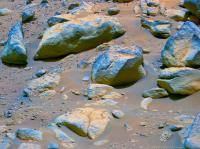
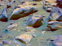
Judging by the false colors, at least two different rock types are visible. Rocks from the lower etched unit (Seitah) appear yellow-brown on the illuminated side, rocks from the Jezero floor unit have a blue tint.


Posted by: tau Jun 3 2021, 06:28 PM
Sol 101 SuperCam with laser shots

Posted by: tau Jun 3 2021, 08:23 PM
A second SuperCam on sol 101: A rock with an imaginative surface, and a small part of it in stereo


Posted by: tau Jun 4 2021, 12:15 PM
Sol 102 Mastcam-Z context image with sol 101 SuperCam image inserted, two stereo images, and a right eye multispectral (filters 0 to 6) PCA image


Posted by: PaulH51 Jun 4 2021, 08:58 PM
Another drive on Sol 103
Looking back at the tracks in this R-Navcam

|
Posted by: Phil Stooke Jun 4 2021, 10:14 PM
I accidentally posted this first in the helicopter thread and am moving it here.
This is the sol 103 parking area. We are a bit to the north of the fifth flight landing point.

|
Phil
Posted by: Ant103 Jun 5 2021, 10:51 AM
Sol 103 Navcam panoramic
https://db-prods.net/marsroversimages/Perseverance/2021/Sol103_pano.jpg
Posted by: tau Jun 5 2021, 01:49 PM
Two SuperCam image series on Sol 103, one with at least 10 laser shots, four of them into the sand, six on the rock to the left.


Posted by: tau Jun 5 2021, 01:57 PM
Sol 103 Mastcam-Z context image with the two Supercam images inserted, a corresponding Mastcam-Z right eye multispectral (filters 0 to 6) PCA image, and a stereo image of the same place.


Posted by: xflare Jun 5 2021, 08:52 PM
Nice view of those shiny rocks seen in the first few sols.
https://mars.nasa.gov/mars2020-raw-images/pub/ods/surface/sol/00104/ids/edr/browse/zcam/ZL0_0104_0676173243_456ECM_N0040430ZCAM08065_110085J01.png
Posted by: Phil Stooke Jun 5 2021, 10:29 PM
Sol 104, another drive. Here's a circular view of the new location:

|
Phil
Posted by: charborob Jun 6 2021, 03:40 AM
Sol 104 LMastcam-Z:
|
|
Posted by: Ant103 Jun 6 2021, 09:31 AM
An other, an other panoramic. Sol 104.
https://db-prods.net/marsroversimages/Perseverance/2021/Sol104_pano.jpg
Posted by: tau Jun 6 2021, 10:24 AM
Kodiak in PCA colors on sol 104.
Note: The colors have been adjusted for a monitor with sRGB color space. On a monitor with an extended color space (e.g. Adobe RGB), some colors may appear too intense. If possible, switch to sRGB.

Posted by: tau Jun 6 2021, 06:52 PM
Sol 104 SuperCam plus context image


Posted by: Phil Stooke Jun 6 2021, 07:25 PM
Thanks for that, it's a very nice thing to see. I wish we had names for some of the things we are seeing. Early in Curiosity's mission most targets only had numbers, but now they all get names. I wonder what the situation is with Perseverance. We will know as soon as the Analysts Notebook gets going at PDS, maybe as soon as August when the first release is due.
Phil
Posted by: PaulH51 Jun 6 2021, 09:26 PM
Another drive on Sol 105, brings us closer to the ejecta? on the edge of a small crater

|
Posted by: vikingmars Jun 7 2021, 06:22 AM
Sol 105 : a faint DD seems to have been captured by the MastCam on two adjacent pictures... or is it a reflection on the lenses ?

|

|
Posted by: vikingmars Jun 7 2021, 07:15 AM
Sol 105 : a nice view of the crater rim taken by the NavCams. Also in 3D. Enjoy

|

|
Posted by: tau Jun 7 2021, 01:18 PM
Sol 105 SuperCam with some laser shots, Mastcam-Z context, and the Mastcam-Z image with enhanced colors


Posted by: tau Jun 7 2021, 02:15 PM
Sol 105: An impressive Martian landscape in stereo. There should be some layered rock fragments, which were excavated out of the underground by the impact.

Posted by: tau Jun 7 2021, 04:34 PM
Another scenic view on sol 105 in stereo.
By the way: Wide-gamut monitors are advantageous when viewing anaglyphs with red-blue or red-green glasses; there is less "ghosting" (show-through of the right image) in the left eye.

Posted by: fredk Jun 7 2021, 08:58 PM
How good filters your 3D glasses use, and whether the images (if jpegs) are stored without chroma subsampling also make a big difference.
Posted by: Phil Stooke Jun 8 2021, 03:25 AM
This is the sol 105 Navcam panorama in circular form. In that nice little field of drifts by the crater rim.
Phil

|
Posted by: tau Jun 8 2021, 12:48 PM
Sol 106 SuperCam (still without context). Does the matrix consist of small elongated crystals?

Posted by: PaulH51 Jun 8 2021, 01:01 PM
Context...

|
Posted by: tau Jun 8 2021, 02:33 PM
Thank you, PaulH51. Here are two Mastcam-Z context images (sol 105 and 106) with the SuperCam image inserted. I expected the rock to be near the rover. Obviously, the structures (crystals?) are not as small as I thought before.


Posted by: charborob Jun 8 2021, 03:51 PM
Sol 106 Mastcam-Z anaglyph:
|
|
Posted by: nprev Jun 8 2021, 03:56 PM
Looks like a fairly typical boulder to me. The vesicles are a bit interesting, but what I think you're interpreting as 'crystals' on the right side appears much more like aeolian weathering.
Posted by: tau Jun 8 2021, 07:06 PM
Meanwhile I prepared a stereo image with this rock. Behind the rocks in the foreground a depression is visible, the crater interior. The rock mentioned above is behind the crater. It is probably the big one in the center of the white circle on the HiRISE map. The distance from the rover to this point is about 100 m.


Posted by: john_s Jun 8 2021, 07:21 PM
I agree with tau that there's something intriguingly geometrical about the surface texture between the obvious pits on that rock. Also agree that it's a marginal detection, but it would be great if we could get a closer look.
John
Posted by: PaulH51 Jun 8 2021, 09:27 PM
A very short drive on sol 107 as seem rear HazCam view of the tracks (Site 4 drive 644)

|
Posted by: Bill Harris Jun 9 2021, 01:17 AM
I tend to agree with John's agreement.
This rock has an interesting texture. It does "seem" basaltic. But without a close up look and determination of the minerology we can't be sure. The 'vesicles' could be aeolian erosion of softer clasts in a conglomerate. Millennia of aeolian erosion in a thin atmosphere can produce alien-looking forms. And remember, this area has experienced many episodes of deposition and erosion of several types for many millions of years. This area will end up being complex beyond comprehension.
I'm interested in mineralogy and provenance of the flat light-toned rocks that we see emplaced like paving stones.
Posted by: tau Jun 9 2021, 09:23 AM
Sol 107 Mastcam-Z left eye and right eye multispectral PCA images, and an anaglyph


Posted by: tau Jun 9 2021, 10:26 AM
A few moments ago new raw images were published. Here again two multispectral images and one anaglyph.


Posted by: tau Jun 9 2021, 03:09 PM
A "Supercamorama" from sol 107 and its context
![]()

Posted by: tau Jun 9 2021, 03:30 PM
A SuperCam photo from sol 106 with context, less panoramic, more grainy, with laser shots into a dune crest.
Posted by: tau Jun 9 2021, 06:42 PM
The previously missing right side of the sol 107 SuperCam context has just arrived. Here now a context panorama with twice the size.

Posted by: Phil Stooke Jun 9 2021, 09:27 PM
https://mars.nasa.gov/news/8963/nasas-perseverance-rover-begins-its-first-science-campaign-on-mars/
This links to the science plan for the next few months - in fact probably the next year. South to study and sample this crater floor material, then north again to circle around and reach the delta.
Phil
Posted by: PaulH51 Jun 10 2021, 01:52 AM
Another drive on Sol 108. end-of-drive R-Navcam (site 4, drive index 738)
|
Posted by: Phil Stooke Jun 10 2021, 03:07 AM
This is a composite of the various plans we have seen for exploration.
Phil

|
Posted by: vikingmars Jun 10 2021, 05:07 AM
Phil
How useful
Thank you Phil
Posted by: Ant103 Jun 10 2021, 08:29 AM
A bunch of new panoramics.
Sol 105, MastcamZ at 110mm.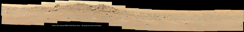
Sol 106, the crater rim, with its rocks.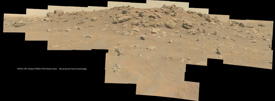
This one, at 34mm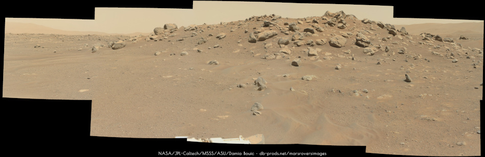
All resolutions available here (just swipe across the timeline) :
https://db-prods.net/marsroversimages/perseverance2021.php#28
Posted by: Phil Stooke Jun 10 2021, 09:40 PM
Excellent work, Damia.
Here is a circular view for sol 108. It took a while to get all the pieces for it - I preferred the single frame Navcams for making a quick panorama but most frames are now coming down as 4 quadrants, better resolution but more work.
Phil
|
Posted by: PaulH51 Jun 10 2021, 10:38 PM
Just when you're catching up... Another drive on Sol 109. Looks like they could be beginning a traverse around the crater.
|
Posted by: Art Martin Jun 10 2021, 11:09 PM
and I think that's the first look at Ingenuity since the last flight. She was hidden behind the crater until now.
Posted by: tau Jun 11 2021, 01:04 PM
Sol 108 Mastcam-Z left eye and right eye filters 0 to 6 multispectral color images and an anaglyph.
Here you will find a full-color stereo image for viewing on a 3D TV.
Posted by: tau Jun 11 2021, 02:36 PM
Sol 109 SuperCam with context and context of the context
Posted by: charborob Jun 11 2021, 07:07 PM
Sol 109 anaglyph:
|
|
Posted by: Phil Stooke Jun 11 2021, 08:55 PM
Sol 109, circular view. There's a nice little crater just to the west.
Phil
|
Posted by: Julius Jun 11 2021, 09:50 PM
To me the southern route that would have the rover pass by Kodiak on its way to the Delta looks more scientifically compelling. Any reason given for a change in direction heading North?
Posted by: Phil Stooke Jun 11 2021, 10:32 PM
It avoids having to cross Seitah. Maybe after detailed study of that region they decided not to risk it.
Meanwhile, catching up a bit (panoramas are coming in a bit at a time, not very convenient for mapping) - here is a circular view for sol 107.

|
Phil
Posted by: PaulH51 Jun 12 2021, 12:31 AM
Yet another drive on Sol 110, brings us further around the small crater, and closer to Ingenuity. As seen in this post drive R-Navcam (Site 4 drive 922)

|
Posted by: Phil Stooke Jun 12 2021, 03:14 AM
Here is the new circular view for sol 110. Easy driving! But much more difficult terrain lies ahead.
Phil

|
Posted by: tau Jun 12 2021, 04:53 PM
Sol 110 SuperCam with context and associated Mastcam-Z left eye multispectral image


Posted by: tau Jun 12 2021, 04:56 PM
Another SuperCam with context on sol 110


Posted by: tau Jun 12 2021, 07:44 PM
Sol 108 SuperCam with context


Posted by: charborob Jun 12 2021, 07:58 PM
Sol 110: anaglyph of the large boulder:

|
Posted by: Toma B Jun 13 2021, 11:14 AM
Beautiful view of Kodiak hill taken on sol 111.
https://flic.kr/p/2m5ghnKhttps://flic.kr/p/2m5ghnK
by https://www.flickr.com/photos/tomabandin/, on Flickr
Posted by: tau Jun 13 2021, 08:10 PM
Sol 111 Mastcam-Z images. Details of the hazy, distant parts of the landscape come out better with some careful transformations of the RGB values.
Here are two raw images and their processed variants. Compression artifacts are starting to become visible.


Posted by: tau Jun 13 2021, 08:23 PM
Same procedure with the Jezero crater wall behind Kodiak hill, raw and processed


Posted by: serpens Jun 13 2021, 11:10 PM
Really nice work tau.
Posted by: Bill Harris Jun 14 2021, 12:22 AM
Here are two raw images and their processed variants. Compression artifacts are starting to become visible.
[attachment=48331:ZL0_0111...4_pc123_.jpg]
Let's see if I can get this Quote to come out right.
On the last processed image of the four, there appears to be a bluish ground haze. I presume that it is some sort of processing artifact. What do you think of it?
Posted by: tau Jun 14 2021, 07:39 AM
My intention was to make small differences in hue and brightness more clearly visible by numerical transformations of the RGB values in the color space, not to reconstruct the true Martian colors. Although these processed images show very Mars-like red-brown colors, they are rather false-color images (blue sky). When the color space is stretched, an orange that is less orange (less saturated) than others may move across the gray axis into the bluish region.
As to what causes the haze - I can only guess. I presume that there is a higher concentration of dust in the air near the ground in some places, and that this dust is less orange-red (more grayish) than the dusty Martian surface. Or is it a material difference on the surface itself? But it is indeed interesting to see this haze (or whatever it is).
Posted by: charborob Jun 14 2021, 11:04 AM
Sol 112 LMastcam-Z:
|
|
Posted by: tau Jun 14 2021, 01:54 PM
Sol 112 SuperCam with context, false-color image, and anaglyph (only the part with overlapping left and right eye images)


Posted by: tau Jun 14 2021, 03:27 PM
The same rock as before, now with "multispectral colors" from filters 0 to 6 in left eye and right eye of Mastcam-Z on sol 112


Posted by: Bill Harris Jun 14 2021, 04:54 PM
Tau--
Indeed.
Posted by: tau Jun 14 2021, 05:12 PM
Sol 112, Mastcam-Z left eye all nine spectral channels (0=RGB and 1 to 6) processed, from right eye only the six infrared channels, and an anaglyph. The processed image of the right eye looks quite alien, or like a surrealistic painting, or both.


Posted by: PaulH51 Jun 15 2021, 04:54 AM
A drive on sol 113, with what appears to be two nice Dust Devils across in 'DD Alley' in the mid-drive L-Navcam tile (timestamp 13:49:50, site 4 - drive 1034)
The second L-Navcam tile acquired at the end of the drive shows us that the DD's have dissipated (timestamp 15:19:20, site 4 - drive 1062)

|
Posted by: tau Jun 15 2021, 09:03 AM
Sol 112 Mastcam-Z panorama

Posted by: tau Jun 15 2021, 09:06 AM
... and Sol 112 panorama anaglyph

Posted by: charborob Jun 15 2021, 01:07 PM
Another sol 112 anaglyph:
|
|
Posted by: tau Jun 15 2021, 05:34 PM
Sol 112 landscape with crater in crater. Regarding the "bluish haze": If it really is dust in the air, then this dust must be much finer (more like smoke) than the dust swirled up in the dust devils, as a comparison with enhanced colors shows (Navcam sol 113, Mastcam-Z sol 112).


Posted by: tau Jun 15 2021, 05:59 PM
Sol 113 SuperCam no. 1

Posted by: tau Jun 15 2021, 06:08 PM
Sol 113 SuperCam no. 2

Posted by: tau Jun 15 2021, 06:10 PM
Sol 113 SuperCam no. 3

Posted by: neo56 Jun 15 2021, 08:01 PM
The two nice dust devils identified by Paul on sol 113. This is a mosaic of two Navcam Left pictures.
https://flic.kr/p/2m5Qdbj
Contrast increased:
https://flic.kr/p/2m5NGSF
Another one in the west direction, between the azimuth of Kodiak and Neretva Vallis.
https://flic.kr/p/2m5FwD6
Posted by: Phil Stooke Jun 15 2021, 10:41 PM
Here is a circular view of the sol 113 location. The dust devil on the delta (EDIT: on the crater wall beyond the delta) is visible in the west (north at the top as usual).
Phil

|
Posted by: charborob Jun 16 2021, 02:17 AM
Sol 113 late afternoon LMastcam-Z panorama:
|
|
Posted by: charborob Jun 16 2021, 02:40 AM
Another sol 113 LMastcam panorama:
|
|
Posted by: Andreas Plesch Jun 16 2021, 02:42 AM
combined sol 114 DD reconnaissance:
|
|
contrast enhanced and sharpened. Animated with 1s frame to frame speed, in reality about 14s.
The N (frames 0-2) and W (frames 12-14) views have broader dust devils. To the N in front of the delta, and to the W pretty much in the same spot where the sol 113 swirl was. There may be another one to the N, on top of the delta.
The SE (frames 6-8) view may also have a very faint swirl left (east) of the center. Perhaps worth detecting with more sensitive methods.
Posted by: Toma B Jun 16 2021, 10:35 PM
Nice view of Ingenuity on sol 114. Hoping to see some more flights.
https://flic.kr/p/2m5SZ4ohttps://flic.kr/p/2m5SZ4o
by https://www.flickr.com/photos/tomabandin/, on Flickr
Posted by: PDP8E Jun 16 2021, 11:37 PM
Sol 114 Dust Devil Watch
360 degree DD quick peek sequence (3 frames per 5 stances)
|
|
Posted by: Andreas Plesch Jun 17 2021, 12:43 AM
360 degree DD quick peek sequence (3 frames per 5 stances)
I think there are several more DD detections. For example, I believe the E view (frames 3-5 above) has one left of center in front of the dark, distant hill, moving left.
Posted by: Andreas Plesch Jun 17 2021, 01:24 AM
Sol114 has the closest https://mars.nasa.gov/mars2020-raw-images/pub/ods/surface/sol/00114/ids/edr/browse/zcam/ZL0_0114_0677061225_832EBY_N0041062ZCAM08094_0630LMJ01.png of Ingenuity after the selfie before the first flight. For easy reference here a slightly gmic enhanced enlargement:

|
Some dust on the wings, but the (carbon fiber?) texture still gets through. The solar panel roof seems pretty shiny. No obvious wear at all.
Posted by: vikingmars Jun 17 2021, 04:15 AM
Two interesting segments of Sol 114 panorama duly processed and also in 3D. Enjoy
Sol 114 segment with Ingenuity
|
|
Posted by: vikingmars Jun 17 2021, 04:17 AM
(Cont.: 3D version)
|
|
Posted by: vikingmars Jun 17 2021, 04:19 AM
Sol 114 segment with the DD
|
|
Posted by: vikingmars Jun 17 2021, 04:22 AM
(Cont.: 3D version)
|
|
Posted by: tau Jun 17 2021, 10:08 AM
Sol 115 SuperCam

Posted by: tau Jun 17 2021, 12:23 PM
Another SuperCam on sol 115 with 10 laser shots

Posted by: tau Jun 17 2021, 12:56 PM
Sol 115 Sherloc Watson camera anaglyph

Posted by: tau Jun 17 2021, 03:05 PM
A very slender dust devil on sol 114. Mastcam-Z left eye and right eye, contrast and colors enhanced.


Posted by: tau Jun 17 2021, 05:20 PM
Sol 114 Mastcam-Z context for sol 115 SuperCam plus anaglyph


Posted by: neo56 Jun 17 2021, 08:51 PM
Nice rocks and ripples imaged by Mastcam-Z Right on sol 113, at 4:29 pm.
https://flic.kr/p/2m6bAw5
And the larger panorama:
https://flic.kr/p/2m6fPtP
Posted by: Phil Stooke Jun 18 2021, 12:51 AM
This link:
https://www.lpi.usra.edu/pac/presentations/0621/03-Meyer-Gramling-MEP-MSR-061421.pdf
goes to a presentation on Mars Sample Return at the recent PAC meeting. It includes a sightly different view of the plan for the next few months, notably saying that the drive south will be a quick survey and the return trip will include the sampling: 4 samples and 4 duplicates plus a witness tube to check contamination.
Phil

|
(PP = Pilot Pinnacle - it was called Pinnacle Point earlier. RR = raised ridges)
Posted by: PaulH51 Jun 18 2021, 02:31 AM
Driving again on sol 116: L-Navcam from the end-of-drive location (site 4 drive 1250)

|
Posted by: tau Jun 18 2021, 11:28 AM
On sol 116 SuperCam photographed a layered outcrop. The SuperCam inset in the context image had to be deformed and cropped due to the parallax between the two takes. As an addition, an anaglyph of the context.


Posted by: charborob Jun 18 2021, 02:14 PM
Sol 116 LMastcam-Z:
|
|
Posted by: Phil Stooke Jun 18 2021, 03:37 PM
The sol 116 location in a circular view.
Phil

|
Posted by: neo56 Jun 18 2021, 06:23 PM
Complete 360° panorama taken on sol 114 with Mastcam-Z Right.
https://flic.kr/p/2m6d3xj
http://gigapan.com/gigapans/226285
Posted by: neo56 Jun 18 2021, 08:20 PM
Sunset on sol 114 captured, as usual, by Navcam Left.
https://flic.kr/p/2m6dW1Q
Posted by: charborob Jun 19 2021, 02:45 AM
Sol 116 anaglyph:

|
Posted by: nprev Jun 19 2021, 03:06 AM
ADMIN NOTE: At the suggestion of PDP8E, there's a new dedicated http://www.unmannedspaceflight.com/index.php?showtopic=8638&st=0#entry253179. 15 posts from this thread were just moved over there. Please post all future observations, animations, etc. over there. Hopefully this will become a very convenient single-point resource.
Posted by: vikingmars Jun 19 2021, 04:11 PM
Sol 116 panorama showing the plains with the crater rim at the background: a very romantic view of Mars indeed.
(Reduced size to fit in the Forum, and in 3D). Enjoy

|
Posted by: vikingmars Jun 19 2021, 04:13 PM
(Cont.: Sol 116 panorama 3D version)

|
Posted by: vikingmars Jun 19 2021, 05:29 PM
Thanks a lot Charborob for your nice 3D processing
I noticed also this round rock that looks like an hamburger
Here it is sitting in a broader 3D context along a small ridge.
Bon Appetit and enjoy
|
|
Posted by: tau Jun 19 2021, 08:46 PM
This round rock seems to be different from the others we have seen so far.
1) Sol 116 Mastcam-Z raw image .
2) Left camera, multispectral PCA image of filters 0 to 6 (mostly visible spectrum). The round rock is as blue as the angular stones in the foreground.
3) Right camera, multispectral PCA image of filters 0 to 6 (mainly infrared spectrum). The round rock is slightly more violet than the angular stones. A small stone in the foreground is clearly different (orange color).
4) Right camera, multispectral PCA image of filters 1 to 6 (infrared spectrum only). The round rock has a distinctly different reflectance in the infrared, an indication of a different rock type.
1
. . 2

. . 3

. . 4


Posted by: charborob Jun 19 2021, 08:59 PM
Sol 117 LMasctam-Z:
|
|
Posted by: Julius Jun 20 2021, 12:37 AM
It's a pity that Percy seems to be unable to traverse Seitah to examine layered rock from up close particularly where it seems to be overlain by volcanic deposits.
Posted by: vikingmars Jun 20 2021, 01:04 AM
1) Sol 116 Mastcam-Z raw image .
2) Left camera, multispectral PCA image of filters 0 to 6 (mostly visible spectrum). The round rock is as blue as the angular stones in the foreground.
3) Right camera, multispectral PCA image of filters 0 to 6 (mainly infrared spectrum). The round rock is slightly more violet than the angular stones. A small stone in the foreground is clearly different (orange color).
4) Right camera, multispectral PCA image of filters 1 to 6 (infrared spectrum only). The round rock has a distinctly different reflectance in the infrared, an indication of a different rock type.
Thank you very much Tau for sharing this great work of yours.
Those reconstructed multispectral images are very nice to see and very interesting indeed
Posted by: Bill Harris Jun 20 2021, 01:56 AM
1) Sol 116 Mastcam-Z raw image .
2) Left camera, multispectral PCA image of filters 0 to 6 (mostly visible spectrum). The round rock is as blue as the angular stones in the foreground.
3) Right camera, multispectral PCA image of filters 0 to 6 (mainly infrared spectrum). The round rock is slightly more violet than the angular stones. A small stone in the foreground is clearly different (orange color).
4) Right camera, multispectral PCA image of filters 1 to 6 (infrared spectrum only). The round rock has a distinctly different reflectance in the infrared, an indication of a different rock type.
1
|
|
|
|
|
|
|
|
Interesting series of lithologies there.
I'm hoping to get a close look at that light-toned unit, which is apparently a bedrock to the overlying residual and aeolian units.
Posted by: tau Jun 20 2021, 12:32 PM
Sol 118 SuperCam no. 1 with Mastcam-Z sol 117 context


Posted by: tau Jun 20 2021, 12:34 PM
Sol 118 SuperCam no. 2 with Mastcam-Z sol 117 context


Posted by: tau Jun 20 2021, 02:01 PM
Sol 118 SuperCam no. 3 with context


Posted by: tau Jun 20 2021, 05:36 PM
Some more multispectral images. A piece of rock with a strikingly different spectral reflectance is encircled.
1) Sol 115 Mastcam-Z raw image .
2) Right camera, multispectral PCA image of filters 0 to 6 (mainly infrared spectrum).
3) Right camera, multispectral PCA image of filters 1 to 6 (infrared spectrum only). A significant portion of the second and third principal components is due to flatfield inhomogeneities and image noise. The yellow spot in the upper right quadrangle is caused by an impurity in filter R6.
1
. . 2

. . 3


Posted by: tau Jun 20 2021, 05:42 PM
Sol 115, another target, same method as above.
1
. . 2

. . 3


Posted by: tau Jun 21 2021, 02:45 PM
Sol 119 SuperCam with Mastcam-Z context from sol 117


Posted by: tau Jun 21 2021, 05:20 PM
Wide-baseline stereo images of Kodiak hill using Mastcam-Z raw images from different sols
1) Red channel: sol 114 12:13:29 and 12:13:41 local mean solar time, blue/green channels: sol 94 12:14:01
Daytime difference less than minute, nearly identical shadows at the cliffs of Kodiak and a stronger stereo effect due to a wider baseline then 2)
2) Red channel: sol 114 12:13:29 and 12:13:41, blue/green channels: sol 111 10:49:27
Daytime difference about 84 minutes, therefore somewhat disturbing different shadows at the cliffs, but with the Jezero crater wall in stereo as background
1
. . 2
![]()

Posted by: vikingmars Jun 22 2021, 08:14 AM
What a nice work Tau. Congratulations
Here is the Sol 115 mosaic, showing the "Hamburger Rock" at right.
Also in 3D to help understand the local topography and put your nice work in context. Enjoy

|

|
Posted by: PaulH51 Jun 22 2021, 09:50 AM
Drive on Sol 120?: Site #4, Drive #1231

|
Posted by: tau Jun 22 2021, 12:21 PM
And here is sol 120 with a new SuperCam take and its context. I considered waiting for photos that continue to the right, where there is a very small layered cliff.
But usually the centers of the SuperCam photos in a series are on a straight line, and then the cliff would not be included. Hopefully it will be included in an extra series.

|

|
Posted by: tau Jun 23 2021, 01:10 PM
Sol 120 SuperCam panorama, consisting of 10 individual photos
|
|
Posted by: tau Jun 23 2021, 01:21 PM
Context of some SuperCam photos from Sol 116 to 120

|
Could this be a reconnaissance for a possible short excursion of Perseverance to Séítah?
Posted by: Phil Stooke Jun 24 2021, 06:54 AM
Possibly! - we have just 2 images (as I write this) from sol 122, but it looks to me as if Perseverance has moved north to a place near the sol 113 position (a short distance SW of it). That may be an access point for a look at the bright rocks.
Phil
Posted by: tau Jun 24 2021, 12:46 PM
Because these vesicular rocks from sol 119 are so three-dimensional, I couldn't resist making a color anaglyph, and a color-enhanced image if there are no red-blue/green glasses for viewing.

|

|
Posted by: tau Jun 24 2021, 01:27 PM
Sol 122 SuperCam no. 1 with Mastcam-Z context from sol 117

|

|
Posted by: tau Jun 24 2021, 01:33 PM
Sol 122 SuperCam no. 2 with extended Mastcam-Z context

|

|
Posted by: Phil Stooke Jun 24 2021, 06:57 PM
I really like these context images, tau - very useful.
This is the sol 122 end of drive circular view - one frame barely touched the horizon. We might get the missing bit later. The tracks show the path very clearly.
Phil

|
Posted by: Phil Stooke Jun 25 2021, 03:54 AM
Here's an updated version of the circular image.
Phil

|
Posted by: Andreas Plesch Jun 25 2021, 05:21 PM
Just a heads up that sol 123 saw a 73m drive to the south, passing the sol 116 location.
Posted by: Phil Stooke Jun 25 2021, 06:59 PM
Yes! Here's a circular view of the new location.
Phil

|
Posted by: tau Jun 25 2021, 08:04 PM
A look back, and here is a rather experimental anaglyph of a Kodiak cliff, composed of two SuperCam image series.
Left eye (red): Sol 77, 08:24:49 and 08:37:27 local mean solar time.
Right eye (blue/green): Sol 63, 08:11:26, 08:12:49, and 08:14:12
Somewhat distracting are the different shadows due to the different sun angles.
Different distances to Kodiak, an additional vertical parallax, and axial distortion of the raw images required manual adjustment of various parts of this anaglyph.
Nevertheless, a stereoscopic effect is visible, although two stereoscopic inconsistencies remained in the scree slope.

|
Posted by: charborob Jun 25 2021, 08:17 PM
Sol 122 anaglyph:

|
Posted by: PaulH51 Jun 26 2021, 11:20 AM
Another drive on Sol 124 takes the rover to a nice looking workspace (site 4: drive 1712)
L-Mastcam-Z - Zoom set at 34mm, raw images assembled in MS-ICE without additional processing

|
Posted by: Phil Stooke Jun 26 2021, 07:20 PM
It was a short drive to the SW on sol 124 to reach a nice outcrop.
Phil

|
Posted by: tau Jun 27 2021, 10:09 AM
A landscape from sol 123 in multispectral PCA colors
1) MastCam-Z left eye filters 0 to 6
2) Right eye filters 0 to 6
3) Anaglyph
1

|

|

|
Posted by: tau Jun 27 2021, 10:17 AM
Another multispectral take of Mastcam-Z from sol 123, left eye and right eye all filters

|

|

|
Posted by: tau Jun 27 2021, 10:52 AM
A multispectral close-up from sol 123
1) Mastcam-Z left eye all filters. The greater rock and the smaller one below are almost the same color.
2) Right eye only infrared filters 1 to 6. Both rocks show a quite different infrared reflectance. Notice the various infrared colors of the sand grains.
3) Anaglyph with colors
1

|

|

|
Posted by: tau Jun 27 2021, 03:20 PM
Sol 124 SuperCam with context and anaglyph

|

|

|
Posted by: tau Jun 27 2021, 08:17 PM
Sol 124 Mastcam-Z multispectral PCA images
1) Left eye, all filters 0 (=RGB) to 6
2) Right eye, all filters 0 (=RGB) to 6
1

|

|
Posted by: tau Jun 27 2021, 08:19 PM
Sol 124 Mastcam-Z anaglyph

|
Posted by: PaulH51 Jun 28 2021, 09:37 AM
Drive on sol 126 as seen in this rear Hazcam frame.

|
Posted by: charborob Jun 28 2021, 02:26 PM
Sol 124 anaglyph:

|
Posted by: Phil Stooke Jun 28 2021, 08:01 PM
sol 126, a circular view of the new location.
Phil

|
Posted by: PaulH51 Jun 29 2021, 02:03 PM
Another drive on sol 127: Keeping up the pace on the survey to the south
end-of-drive Navcam tile looking back at the freshly laid tracks

|
Posted by: Phil Stooke Jun 29 2021, 06:20 PM
Circular view on sol 127.
Phil

|
Posted by: tau Jun 29 2021, 07:28 PM
Sol 127 Supercam with Mastcam-Z context and color-enhanced context image with laser shots in the center

|

|

|
Posted by: tau Jun 30 2021, 09:04 AM
Sol 127: a color-enhanced landscape, and the same view as a wide-baseline stereoscopic image (for the left eye sol 127, for the right eye sol 114)

|

|
Posted by: PaulH51 Jun 30 2021, 11:53 AM
Reverse rock climbing exercise on sol 128 (site 4, drive index 1878)
Appears as though they reversed back over a rock they drove over at the end of the sol 127 drive?
Images (Hazcam & Navcam) from sol 128

|

|
Hazcam from sol 127:

|
Posted by: Bill Harris Jun 30 2021, 05:54 PM
Was running up over the boulder intentional or was it a mistake? It seems to be a risky maneuver.
Posted by: Phil Stooke Jun 30 2021, 06:56 PM
If you run over it with one wheel it might be better to back up than to go ahead, halving the number of other wheels having to climb the rock.
Here is a circular view and a close-up of the area.
Phil

|

|
Posted by: tau Jun 30 2021, 07:13 PM
Sol 128 Supercam panorama and its context in a sol 127 Mastcam-Z image
|
|

|
Posted by: serpens Jul 1 2021, 12:08 AM
The autonomous drive seemed comfortable with climbing the rock, but leery of the combination of the raised rock between the wheels and the configuration of the end of the sand drift.
Posted by: tau Jul 1 2021, 08:45 PM
Sol 129 SuperCam with context from sol 128.
Some remarkably bright rock fragments on the far right of the SuperCam image.
Distortion of the SuperCam inset in the Mastcam Z image due to parallax between the two takes.

|

|
Posted by: Phil Stooke Jul 1 2021, 08:52 PM
Sol 129, a circular view and a close-up.
Phil

|

|
Posted by: PaulH51 Jul 1 2021, 10:07 PM
Phil
Thanks Phil, really enjoy your circular views
Do you think the rover has crossed into the next map quadrangle at the Sol 129 drive?
It looks close on the map I have, but it's not really high enough resolution to be sure

|
Posted by: Phil Stooke Jul 1 2021, 10:53 PM
Right about on the boundary, I would say. I hope we start getting some more names of features soon. A map is naked without names!
Phil
Posted by: PaulH51 Jul 2 2021, 02:55 AM
Phil
Agreed fully re feature names, Now that the most of the hardware and the majority of the instruments have been fully commissioned, I hope that the team members will soon be in a position where they can share a few mission updates.
Posted by: tau Jul 2 2021, 12:38 PM
Sol 129 SuperCam no. 2 with Navcam context and Navcam anaglyph

|

|

|
Posted by: tau Jul 2 2021, 03:08 PM
Sol 129 SuperCam no. 3 with sol 128 Mastcam-Z context

|

|
Posted by: Phil Stooke Jul 2 2021, 05:51 PM
Sol 130, a circular view after a drive to the southeast. Over 100 m, the longest drive to date. The Autonav is getting a workout.
Phil

|
Posted by: tau Jul 2 2021, 09:15 PM
Sol 130 SuperCam image (still without context)

|
Posted by: Phil Stooke Jul 3 2021, 03:06 AM
Good news for us remote followers of the mission...
https://mars.nasa.gov/mars2020/mission/status/
"Blog Coming Soon
Mission team members are getting ready to share their stories with you as they explore Jezero crater with the help of the Mars Perseverance rover. "
Mission team - thank you for this. We understand how crazy everything must have been for the last 130 sols, but this will be greatly appreciated!
Phil
Posted by: tau Jul 3 2021, 10:26 AM
Here is the context for the SuperCam image from sol 130.
The purpose of the fierce action with the wheels on sol 129 was presumably to excavate parts of rocks which have not been subjected to weathering for millions of years.

|

|
Posted by: tau Jul 3 2021, 10:57 AM
Thorough photography of the partially excavated rock
1) Mastcam-Z right eye, original RGB colors
2) Left eye multispectral filters 0 to 6, colors transformed with PCA
3) Right eye multispectral filters 0 to 6, colors transformed with PCA
4) Anaglyph
1

|

|

|

|
Posted by: tau Jul 3 2021, 01:51 PM
Another possible reason for the wheel action on sol 129: the intention to get a fresh rock surface by driving over a rock with fractures like this one and breaking it (which apparently did not happen).

|

|
Posted by: tau Jul 3 2021, 06:44 PM
A multispectral landscape on sol 129, Mastcam-Z left eye and right eye, all filters 0 to 6

|

|
Posted by: tau Jul 3 2021, 06:46 PM
. . . and the sol 129 landscape in stereo

|

Posted by: Phil Stooke Jul 4 2021, 12:06 AM
Sol 131, a circular view of our new location.
Phil

|
Posted by: tau Jul 5 2021, 03:55 PM
Sol 132: The rock slabs over there remind me of Solnhofen slab limestone.

|

|
Posted by: tau Jul 5 2021, 04:01 PM
Sol 132 landscape

|

|
Posted by: PaulH51 Jul 6 2021, 02:43 PM
Driving on sol 134: Here's a pair of NavCam tiles looking back at the tracks and some of the extensive boulder field that the rover has picked its way through to continue it drive to the next major science waypoint close to the helicopters current location. The mosaic has been very roughly processed, but it should provide a taste of the terrain behind the rover at the end of the drive at site 5 / drive 894, and maybe help pinpoint its location.

|
Posted by: Phil Stooke Jul 6 2021, 04:25 PM
We came about 90 m south - map update coning soon.
Phil
Posted by: Phil Stooke Jul 6 2021, 07:07 PM
Here's a circular panorama of the site.
Phil

|
Posted by: PaulH51 Jul 7 2021, 02:51 PM
Another drive on Sol 135 as seen in this end-of drive Navcam looking across Seitah from site# 5 / drive# 1370.
Another long drive?

|
Posted by: Phil Stooke Jul 7 2021, 05:47 PM
80 or 90 m drive! We only have a partial panorama so far but it gives me a location - map will be posted ASAP.
Phil
Posted by: tau Jul 7 2021, 06:28 PM
Sol 134 vista with enhanced colors and a slightly enlarged anaglyph

|

|
Posted by: Steve G Jul 7 2021, 07:10 PM
Is it my imagination, or are all the big rocks angled in the same direction?
Posted by: djellison Jul 7 2021, 07:25 PM
A few billion years of prevailing wind erosion will do that.
Posted by: Bill Harris Jul 8 2021, 02:08 AM
Indeed, although I don't see them as nice lithographic limestone. I see them as fine clastics deposited in a lacustrine or lagoonal environment, before the serious deltaic sediments started in.
--Bill
Posted by: serpens Jul 8 2021, 06:13 AM
As with tau's image of the sol 134 vista, I suspect that we are seeing the eroded remnants of the extrusive lava flow.
Posted by: tau Jul 8 2021, 12:14 PM
Sol 133 SuperCam image (some laser shots are marked with crosses) and a sol 134 Mastcam-Z context image.
Are they using a time loop to take context photos tomorrow for selecting targets for the laser today?

|

|
Posted by: tau Jul 8 2021, 12:17 PM
The sol 133 SuperCam target rock in Mastcam-Z images from sol 134.
1) Filter 0 visible RGB colors contrast enhanced
2) Left eye filters 0 to 6 multispectral channels PCA transformed
3) Anaglyph
1

|

|

|
Powered by Invision Power Board (http://www.invisionboard.com)
© Invision Power Services (http://www.invisionpower.com)