Perseverance Route Map |

  |
Perseverance Route Map |
 Mar 16 2021, 07:07 PM Mar 16 2021, 07:07 PM
Post
#31
|
||
|
Solar System Cartographer  Group: Members Posts: 10147 Joined: 5-April 05 From: Canada Member No.: 227 |
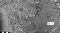
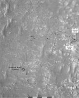
This map shows feature names around the landing area mentioned at LPSC today. There are some diacriticals which I have not figured out yet, but which will be added later.
Phil
-------------------- ... because the Solar System ain't gonna map itself.
Also to be found posting similar content on https://mastodon.social/@PhilStooke NOTE: everything created by me which I post on UMSF is considered to be in the public domain (NOT CC, public domain) |
|
 |
 
|
|
|
Mar 16 2021, 10:59 PM
Post
#32
|
||
 Member Group: Members Posts: 349 Joined: 20-June 07 From: Slovenia Member No.: 2461 |
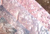
sol 23 update Only Rover Descent Camera images are used. |
|
|
|
|
|
|
Mar 17 2021, 09:19 PM
Post
#33
|
||
|
Solar System Cartographer Group: Members Posts: 10147 Joined: 5-April 05 From: Canada Member No.: 227 |
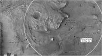
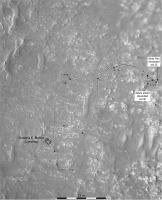
This is my previous map with the appropriate characters added.
Phil
-------------------- ... because the Solar System ain't gonna map itself.
Also to be found posting similar content on https://mastodon.social/@PhilStooke NOTE: everything created by me which I post on UMSF is considered to be in the public domain (NOT CC, public domain) |
|
|
|
|
|
|
Mar 21 2021, 09:40 PM
Post
#34
|
||
|
Solar System Cartographer Group: Members Posts: 10147 Joined: 5-April 05 From: Canada Member No.: 227 |
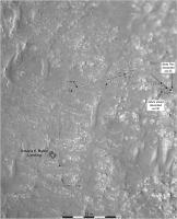
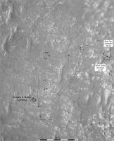
Sol 30 update:
Phil -------------------- ... because the Solar System ain't gonna map itself.
Also to be found posting similar content on https://mastodon.social/@PhilStooke NOTE: everything created by me which I post on UMSF is considered to be in the public domain (NOT CC, public domain) |
|
|
|
|
|
|
Mar 22 2021, 08:42 AM
Post
#35
|
||
|
Member Group: Members Posts: 349 Joined: 20-June 07 From: Slovenia Member No.: 2461 |
map update |
|
|
|
|
|
|
Mar 22 2021, 11:34 PM
Post
#36
|
||
|
Solar System Cartographer Group: Members Posts: 10147 Joined: 5-April 05 From: Canada Member No.: 227 |
Using Hazcams I have plotted the path to sol 31.
Phil
Attached thumbnail(s)
-------------------- ... because the Solar System ain't gonna map itself.
Also to be found posting similar content on https://mastodon.social/@PhilStooke NOTE: everything created by me which I post on UMSF is considered to be in the public domain (NOT CC, public domain) |
|
|
|
|
|
|
Mar 23 2021, 09:19 PM
Post
#37
|
||
|
Solar System Cartographer Group: Members Posts: 10147 Joined: 5-April 05 From: Canada Member No.: 227 |
The partial panorama in the early drives thread gives the path and location for sol 32.
Phil
-------------------- ... because the Solar System ain't gonna map itself.
Also to be found posting similar content on https://mastodon.social/@PhilStooke NOTE: everything created by me which I post on UMSF is considered to be in the public domain (NOT CC, public domain) |
|
|
|
|
|
|
Mar 24 2021, 01:07 AM
Post
#38
|
|
|
Member Group: Members Posts: 122 Joined: 19-June 07 Member No.: 2455 |
Phil, I took your route map and superimposed a photo from JPL of the flight zone of Ingenuity. You can see they got very close to the drop off point with the latest drive.
 location_sol_32 + flight zone location_sol_32 + flight zone
|
|
|
|
|
Mar 24 2021, 02:08 AM
Post
#39
|
|
|
Solar System Cartographer Group: Members Posts: 10147 Joined: 5-April 05 From: Canada Member No.: 227 |
Thanks! Very useful.
Phil -------------------- ... because the Solar System ain't gonna map itself.
Also to be found posting similar content on https://mastodon.social/@PhilStooke NOTE: everything created by me which I post on UMSF is considered to be in the public domain (NOT CC, public domain) |
|
|
|
|
Mar 24 2021, 02:45 AM
Post
#40
|
|
|
Member Group: Members Posts: 248 Joined: 25-February 21 From: Waltham, Massachussetts, U.S.A. Member No.: 8974 |
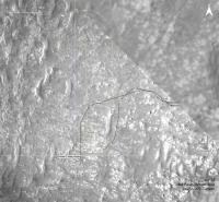
Another map based on the NASA geojson with simulated wheel tracks, 2.7m apart, pills from the traverse data, yaw arrows at way points, the airfield target and the overlook position:
 And a full map with more context: 
-------------------- --
Andreas Plesch, andreasplesch at gmail dot com |
|
|
|
|
Mar 24 2021, 10:18 AM
Post
#41
|
||
|
Member Group: Members Posts: 349 Joined: 20-June 07 From: Slovenia Member No.: 2461 |
Sol 32 update. |
|
|
|
|
|
|
Mar 25 2021, 03:15 AM
Post
#42
|
||
|
Solar System Cartographer Group: Members Posts: 10147 Joined: 5-April 05 From: Canada Member No.: 227 |
We have just 5 images from sol 33 down from Perseverance as I write this, but with one Navcam and one rear Hazcam there is enough information to approximate the drive:
Phil -------------------- ... because the Solar System ain't gonna map itself.
Also to be found posting similar content on https://mastodon.social/@PhilStooke NOTE: everything created by me which I post on UMSF is considered to be in the public domain (NOT CC, public domain) |
|
|
|
|
|
|
Mar 25 2021, 10:43 PM
Post
#43
|
|
|
Member Group: Members Posts: 248 Joined: 25-February 21 From: Waltham, Massachussetts, U.S.A. Member No.: 8974 |
sol 33 update: The flight zone is 30m wide in this map.
 full map 
-------------------- --
Andreas Plesch, andreasplesch at gmail dot com |
|
|
|
|
Mar 26 2021, 06:51 AM
Post
#44
|
||
|
Solar System Cartographer Group: Members Posts: 10147 Joined: 5-April 05 From: Canada Member No.: 227 |
Quick update for the drive to the airfield on sol 34.
Phil
-------------------- ... because the Solar System ain't gonna map itself.
Also to be found posting similar content on https://mastodon.social/@PhilStooke NOTE: everything created by me which I post on UMSF is considered to be in the public domain (NOT CC, public domain) |
|
|
|
|
|
|
Mar 26 2021, 09:00 AM
Post
#45
|
|
|
Member Group: Members Posts: 153 Joined: 4-May 11 From: Pardubice, CZ Member No.: 5979 |
QUOTE (Phil Stooke @ Mar 26 2021, 07:51 AM)  Quick update for the drive to the airfield on sol 34. Phil, could you please (at least for the Ingenuity test period) mark the Helipad (3x3 m) and Airfield (10x10 m) borders into your map for our better orientation? Thanks |
|
|
|
|

|
Lo-Fi Version | Time is now: 20th April 2024 - 03:40 PM |
|
RULES AND GUIDELINES Please read the Forum Rules and Guidelines before posting. IMAGE COPYRIGHT |
OPINIONS AND MODERATION Opinions expressed on UnmannedSpaceflight.com are those of the individual posters and do not necessarily reflect the opinions of UnmannedSpaceflight.com or The Planetary Society. The all-volunteer UnmannedSpaceflight.com moderation team is wholly independent of The Planetary Society. The Planetary Society has no influence over decisions made by the UnmannedSpaceflight.com moderators. |
SUPPORT THE FORUM Unmannedspaceflight.com is funded by the Planetary Society. Please consider supporting our work and many other projects by donating to the Society or becoming a member. |
|