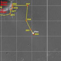
Opportunity Route Map |

  |
Opportunity Route Map |
 Mar 30 2011, 09:25 PM Mar 30 2011, 09:25 PM
Post
#2956
|
|
|
Senior Member  Group: Moderator Posts: 4279 Joined: 19-April 05 From: .br at .es Member No.: 253 |
|
 |
 
|
|
Mar 30 2011, 10:03 PM
Post
#2957
|
|
 Senior Member Group: Moderator Posts: 3232 Joined: 11-February 04 From: Tucson, AZ Member No.: 23 |
10 more kilometers and it can pass Lunokhod 2's record traverse

-------------------- &@^^!% Jim! I'm a geologist, not a physicist!
The Gish Bar Times - A Blog all about Jupiter's Moon Io |
|
|
|
|
Mar 30 2011, 10:24 PM
Post
#2958
|
|
|
Senior Member Group: Members Posts: 3516 Joined: 4-November 05 From: North Wales Member No.: 542 |
No doubt about it the Lunokhods are a significant outlier in the history of unmanned spaceflight. Your post prompts a question for posters here. Let's say Opportunity does cover another 10 kilometres. Is anyone willing to put a pin on the map suggesting its likely location?
|
|
|
|
|
Mar 31 2011, 01:36 AM
Post
#2959
|
|
|
Founder Group: Chairman Posts: 14432 Joined: 8-February 04 Member No.: 1 |
Not the right place for such a discussion ( I'll ban myself later ) - but basically, Cape York / Tribulation - spend a km or 2 there, then we'd end up 2km south following the rim, I'd guess.
|
|
|
|
|
Apr 1 2011, 05:37 PM
Post
#2960
|
|
|
Senior Member Group: Moderator Posts: 4279 Joined: 19-April 05 From: .br at .es Member No.: 253 |
|
|
|
|
|
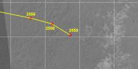
Apr 3 2011, 09:33 PM
Post
#2961
|
||
|
Senior Member Group: Moderator Posts: 4279 Joined: 19-April 05 From: .br at .es Member No.: 253 |
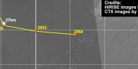
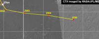
... and another one. You may note that we're moving to another picture.
 Route_Map_Sol2556.kml ( 76.72K )
Number of downloads: 510
Route_Map_Sol2556.kml ( 76.72K )
Number of downloads: 510 |
|
|
|
|
|
|
Apr 4 2011, 08:37 AM
Post
#2962
|
|
|
Member Group: Members Posts: 307 Joined: 16-March 05 Member No.: 198 |
QUOTE (Tesheiner @ Apr 4 2011, 08:33 AM)  You may note that we're moving to another picture. I notice that the grid in the latest map segment has shifted east and no longer matches the grid pattern of the previous segments. For example, the 27km point is now on the eastern (right-hand) side of its nearest longitude grid line rather than on the western (left-hand) side of that same line. Is that a consequence of moving to the new picture? (Or has there been an adjustment to the positions of the endpoints of the last few drives?) |
|
|
|
|
Apr 4 2011, 11:21 AM
Post
#2963
|
|
|
Solar System Cartographer Group: Members Posts: 10150 Joined: 5-April 05 From: Canada Member No.: 227 |
Endpoints moved - changing from estimates to observed locations as the pictures became available. The grid is pure geometry - that's what you line up with the previous view.
Phil -------------------- ... because the Solar System ain't gonna map itself.
Also to be found posting similar content on https://mastodon.social/@PhilStooke NOTE: everything created by me which I post on UMSF is considered to be in the public domain (NOT CC, public domain) |
|
|
|
|
Apr 5 2011, 06:19 PM
Post
#2964
|
|
|
Senior Member Group: Moderator Posts: 4279 Joined: 19-April 05 From: .br at .es Member No.: 253 |
|
|
|
|
|
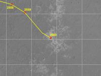
Apr 6 2011, 04:53 PM
Post
#2965
|
||
|
Senior Member Group: Moderator Posts: 4279 Joined: 19-April 05 From: .br at .es Member No.: 253 |
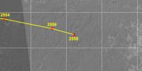
One more update; sol 2559.
Route_Map_Sol2559.kml ( 77.12K )
Number of downloads: 484(I know, I know I shouldn't be doing this kind of math.) 
|
|
|
|
|
|
|
Apr 7 2011, 10:43 AM
Post
#2966
|
|
|
Senior Member Group: Moderator Posts: 4279 Joined: 19-April 05 From: .br at .es Member No.: 253 |
Moved odometry related posts to the main thread.
|
|
|
|
|
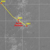
Apr 8 2011, 08:27 AM
Post
#2967
|
|
|
Senior Member Group: Moderator Posts: 4279 Joined: 19-April 05 From: .br at .es Member No.: 253 |
|
|
|
|
|
Apr 8 2011, 08:18 PM
Post
#2968
|
|
|
Senior Member Group: Moderator Posts: 4279 Joined: 19-April 05 From: .br at .es Member No.: 253 |
|
|
|
|
|
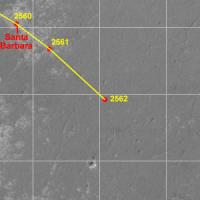
Apr 9 2011, 08:09 PM
Post
#2969
|
|
|
Senior Member Group: Moderator Posts: 4279 Joined: 19-April 05 From: .br at .es Member No.: 253 |
|
|
|
|
|
Apr 10 2011, 06:07 AM
Post
#2970
|
|
 Senior Member Group: Members Posts: 2228 Joined: 1-December 04 From: Marble Falls, Texas, USA Member No.: 116 |
I had made a comment in the other thread several sols ago that this dark terrain that Opportunity was crossing was fraught with fractures, and that it appeared to be a dangerous place to drive. I am relieved to see that our girl skipped right through it with nary a care.
In retrospect, most of the cracks were apparently filled with sediment and not of concern. Some of the scariest ruts were niftily avoided by Oppy's expert drivers, as we have all come to expect. I see more fractured terrain ahead. ...steady as she goes, Scotty, steady as she goes...  -------------------- ...Tom
I'm not a Space Fan, I'm a Space Exploration Enthusiast. |
|
|
|
|

|
Lo-Fi Version | Time is now: 24th April 2024 - 02:35 PM |
|
RULES AND GUIDELINES Please read the Forum Rules and Guidelines before posting. IMAGE COPYRIGHT |
OPINIONS AND MODERATION Opinions expressed on UnmannedSpaceflight.com are those of the individual posters and do not necessarily reflect the opinions of UnmannedSpaceflight.com or The Planetary Society. The all-volunteer UnmannedSpaceflight.com moderation team is wholly independent of The Planetary Society. The Planetary Society has no influence over decisions made by the UnmannedSpaceflight.com moderators. |
SUPPORT THE FORUM Unmannedspaceflight.com is funded by the Planetary Society. Please consider supporting our work and many other projects by donating to the Society or becoming a member. |
|