Exploring Mt Sharp north of the dunes - Part 1: Beyond Pahrump Hills, Site 45-50, Sol 923-1147, March 12-October 28, 2015 |

  |
Exploring Mt Sharp north of the dunes - Part 1: Beyond Pahrump Hills, Site 45-50, Sol 923-1147, March 12-October 28, 2015 |
 Jul 1 2015, 10:46 PM Jul 1 2015, 10:46 PM
Post
#511
|
||||
|
Member  Group: Members Posts: 866 Joined: 15-March 05 From: Santa Cruz, CA Member No.: 196 |
some interesting crosseyes from sol1031 MAHLI, sol1030 Navcams showing the 'mud pie' slice and poorly-debayered sol1003/1027 closeup
|
|||
 |
 
|
|||
|
Jul 2 2015, 06:07 AM
Post
#512
|
|
 Senior Member Group: Members Posts: 2428 Joined: 30-January 13 From: Penang, Malaysia. Member No.: 6853 |
USGS Curiosity Mission Update - Sol 1032: Lots of Contact Science, by Ryan Anderson LINK
|
|
|
|
|
Jul 2 2015, 06:44 AM
Post
#513
|
|
|
Senior Member Group: Members Posts: 2428 Joined: 30-January 13 From: Penang, Malaysia. Member No.: 6853 |
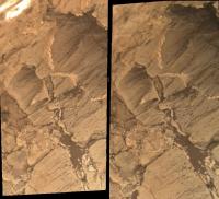
The geological contact zone at Missoula in this cropped MAHLI mosaic.
 It appears that the lower unit (mudstone?) is not as resistant to erosion, when compared with the upper unit (coarse sandstone) at this location |
|
|
|
|
Jul 2 2015, 07:20 AM
Post
#514
|
||
 Senior Member Group: Members Posts: 2173 Joined: 28-December 04 From: Florida, USA Member No.: 132 |
QUOTE (PaulH51 @ Jul 2 2015, 02:44 AM)  The geological contact zone at Missoula in this cropped MAHLI mosaic... There seems to be a duplication of features in the area circled.
|
|
|
|
|
|
|
Jul 2 2015, 08:32 AM
Post
#515
|
|
|
Senior Member Group: Members Posts: 2428 Joined: 30-January 13 From: Penang, Malaysia. Member No.: 6853 |
QUOTE (centsworth_II @ Jul 2 2015, 03:20 PM) There seems to be a duplication of features in the area circled. Thanks, I missed that...  I used MS ICE, will try again and see if I can get it to stitch correctly. I used MS ICE, will try again and see if I can get it to stitch correctly.EDIT I was saved by the focused merged images that have since been down-linked, I hope these have been better stitched. Clicking the image will open the 1024x573 version. 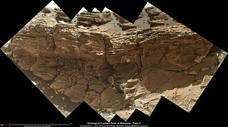 If I am interpreting the thumbnails correctly they used 16 separate images to create each the focus merged products. It's the most I have ever noticed, normally we see 8. Thanks to Gerald for the MAHLI Rule. Full size (3801 x 2126) LINK |
|
|
|
|
Jul 2 2015, 12:51 PM
Post
#516
|
|
|
Junior Member Group: Members Posts: 42 Joined: 19-October 12 Member No.: 6719 |
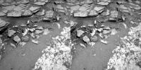
QUOTE (PaulH51 @ Jun 30 2015, 05:29 AM) A small mosaic using 3 focus stacked MAHLI images of "Big Arm" using white LED lighting on sol 1028 (June 28, 2015)  The target is mentioned in this USGS Mission Update from Lauren Edgar : Sol 1030: Bumping to Missoula I don't know about the rest of you, but I found this MAHLI set of images to be rather extraordinary. Would a geologist care to comment on this? To my untrained eye, it appears to be rounded (stream-borne?) gravels deposited in what appears to be in a loosely sorted out-wash area. Obviously these gravels have been seen earlier in the MSL trip to Mt Sharp, but this appears to be another example, or am I wrong? |
|
|
|
|
Jul 2 2015, 01:13 PM
Post
#517
|
||
 Member Group: Members Posts: 334 Joined: 11-December 12 From: The home of Corby Crater (Corby-England) Member No.: 6783 |
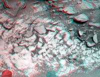
A NavCam anaglyph from sol 1030
Worth a zoom or two for the wafer thin overhanging rocks. It's like they're in competition to see who can overhang the furthest before breaking off.  "Just...a.....little.......further!" |
|
|
|
|
|
|
Jul 2 2015, 04:48 PM
Post
#518
|
|
|
Junior Member Group: Members Posts: 30 Joined: 6-September 12 From: Denver Member No.: 6641 |
QUOTE (PaulH51 @ Jul 2 2015, 02:32 AM) If I am interpreting the thumbnails correctly they used 16 separate images to create each the focus merged products. It's the most I have ever noticed, normally we see 8. Thanks to Gerald for the MAHLI Rule. Full size (3801 x 2126) LINK Beautiful contact! It does not look like an unconformity. It is not obvious to me that any erosion took place between the deposition of the different rock units. However, since the lower unit has substantial veining, and the upper unit does not, there would appear to be a significant change in deposition environment and probably a significant age difference. I love speculating geology from a 100 million kilometers away. |
|
|
|
|
Jul 3 2015, 01:15 AM
Post
#519
|
|
|
Senior Member Group: Members Posts: 2428 Joined: 30-January 13 From: Penang, Malaysia. Member No.: 6853 |
USGS Curiosity Mission Update, Sol 1033-1036 Independence Day Planning, from Ryan Anderson LINK
|
|
|
|
|
Jul 3 2015, 06:16 AM
Post
#520
|
||
|
Senior Member Group: Members Posts: 2824 Joined: 22-April 05 From: Ridderkerk, Netherlands Member No.: 353 |
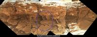
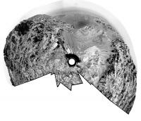
The Navcam L panoramic view stitched together from images taken on Sol 1030 and Sol 1032.
Jan van Driel
|
|
|
|
|
|
|
Jul 3 2015, 09:26 AM
Post
#521
|
|
|
Senior Member Group: Members Posts: 2428 Joined: 30-January 13 From: Penang, Malaysia. Member No.: 6853 |
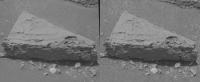
Rough and Ready anaglyph of "Steeley", a rock damaged by the rovers wheels, Sol 1032.
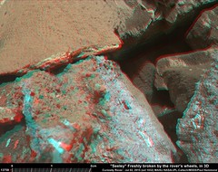 Full size: LINK |
|
|
|
|
Jul 3 2015, 10:33 AM
Post
#522
|
|
|
Senior Member Group: Members Posts: 1043 Joined: 17-February 09 Member No.: 4605 |
QUOTE (PaulH51 @ Jul 2 2015, 06:44 AM) ...It appears that the lower unit (mudstone?) is not as resistant to erosion, when compared with the upper unit (coarse sandstone) at this location That seems possible. If the veins are an indication of hydrofracturing then their termination could be due to a change in the lithology (mechanical properties) of the overlying layer. If so then there may have been no great time between the deposition of the two layers with the veining a product of a later event from a deeper reservoir. |
|
|
|
|
Jul 3 2015, 07:34 PM
Post
#523
|
||
|
Solar System Cartographer Group: Members Posts: 10159 Joined: 5-April 05 From: Canada Member No.: 227 |
Jan's panorama in circular format to show where we are.
Phil
-------------------- ... because the Solar System ain't gonna map itself.
Also to be found posting similar content on https://mastodon.social/@PhilStooke Maps for download (free PD: https://upload.wikimedia.org/wikipedia/comm...Cartography.pdf NOTE: everything created by me which I post on UMSF is considered to be in the public domain (NOT CC, public domain) |
|
|
|
|
|
|
Jul 4 2015, 08:18 AM
Post
#524
|
|
|
Senior Member Group: Members Posts: 2428 Joined: 30-January 13 From: Penang, Malaysia. Member No.: 6853 |
RMI of one of the heavily sculpted laminations, shown in context with its MastCam image, both acquired on sol 1032 (July 2, 2015)
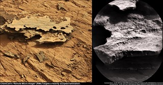 Edit: typo in image text corrected |
|
|
|
|
Jul 5 2015, 04:40 PM
Post
#525
|
|||
 Member Group: Members Posts: 215 Joined: 23-October 12 From: Russia Member No.: 6725 |
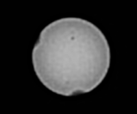
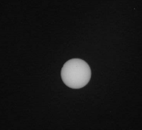
Solar eclipce and solar spots at Sol 1032. (Solar spots from SDO at June 20).
Attached thumbnail(s)
-------------------- My blog on Patreon
|
||
|
|
|
||
|

|
Lo-Fi Version | Time is now: 6th May 2024 - 10:22 PM |
|
RULES AND GUIDELINES Please read the Forum Rules and Guidelines before posting. IMAGE COPYRIGHT |
OPINIONS AND MODERATION Opinions expressed on UnmannedSpaceflight.com are those of the individual posters and do not necessarily reflect the opinions of UnmannedSpaceflight.com or The Planetary Society. The all-volunteer UnmannedSpaceflight.com moderation team is wholly independent of The Planetary Society. The Planetary Society has no influence over decisions made by the UnmannedSpaceflight.com moderators. |
SUPPORT THE FORUM Unmannedspaceflight.com is funded by the Planetary Society. Please consider supporting our work and many other projects by donating to the Society or becoming a member. |
|